Bridge Statistics for New Johnsonville, Tennessee (TN)
Condition, Traffic, Stress, Structural Evaluation, Project Costs
- National Bridge Inventory (NBI) Statistics
- 25Number of bridges
- 203ft / 62.0mTotal length
- $5,349,000Total costs
- 107,269Total average daily traffic
- 17,324Total average daily truck traffic
- National Bridge Inventory (NBI) Registered Bridges for New Johnsonville
- No street view available for this location
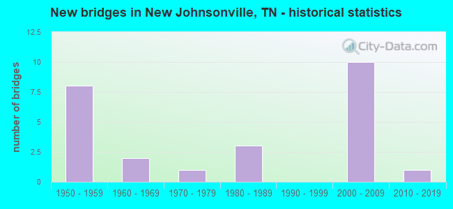
- New bridges - historical statistics
- 81950-1959
- 21960-1969
- 11970-1979
- 31980-1989
- 102000-2009
- 12010-2019


- Bridge Condition - Deck
- 20.0%Very good
- 30.0%Good
- 10.0%Satisfactory
- 20.0%Fair
- 10.0%Serious
- 10.0%Failed

- Bridge Condition - Superstructure
- 10.0%Excellent
- 20.0%Very good
- 30.0%Good
- 20.0%Fair
- 20.0%Failed

- Bridge Condition - Substructure
- 10.0%Excellent
- 20.0%Very good
- 10.0%Good
- 40.0%Fair
- 20.0%Failed

- Bridge Condition - Channel
- 17.6%Very good
- 35.3%Good
- 35.3%Satisfactory
- 11.8%Failed

- Bridge Condition - Culverts
- 30.0%Good
- 10.0%Satisfactory
- 60.0%Fair
Find on map >> Show street view
Structure Number: 30A3000001, Location: 4.1 MI SE JCT SR69&SR192 (Lat: 35.956083, Lng: -88.046167), Route carried "on" structure: County highway 300, Year Built: 1970, Status: Open, Structure Length: 0.76m (2.49ft), Average Daily Traffic: 120 (year 2022), Truck Traffic: 2%, Average Future Daily Traffic: 192 (year 2040), Design Load: H 10, Features Intersected: DALTON CREEK
Minimum Vertical Clearance: 30+ m (98+ ft), Kilometerpoint: 4.725, Lanes on structure: 2, Owner: County Highway Agency, Approaching Roadway Width: 8.8m (28.9ft), Skew: 3 degrees, Material/Design: Concrete continuous, Design/Construction: Culvert, Number Of Spans In Main Unit: 2, Length of Maximum Span: 3.7m (12.1ft), Curb-To-Curb Width: 8.5m (27.9ft), Out-to-Out Width: 9.0m (29.5ft)
Condition: Channel: Satisfactory, Culverts: Satisfactory, Operating Rating: 58.5 metric tons, Method Used To Determine Operating Rating: Load Factor (LF), Inventory Rating: 32.4 metric tons, Method Used To Determine Inventory Rating: Load Factor (LF), Structural Evaluation: Equal to present minimum criteria, Deck Geometry: Equal to present minimum criteria, Waterway Adequacy: Somewhat better than minimum adequacy, Approach Roadway Alignment: Equal to present desirable criteria, Designated Inspection Frequency: Every 24 months, Inspection Date: January 2022, Deck Structure Type: Concrete Cast-file-Place, Wearing Surface/Protective System: Wearing Surface: Bituminous
Find on map >> Show street view
Structure Number: 3S80420001, Location: 5.3 MI SE JCT SR1&SR191 (Lat: 35.986611, Lng: -88.052528), Route carried "on" structure: State highway 191, Year Built: 1965, Year Reconstructed: 1990, Status: Open, Structure Length: 5.21m (17.09ft), Average Daily Traffic: 992 (year 2020), Truck Traffic: 4%, Average Future Daily Traffic: 1,024 (year 2041), Design Load: HS 20, Features Intersected: BIRDSONG CREEK
Minimum Vertical Clearance: 30+ m (98+ ft), Kilometerpoint: 15.498, Lanes on structure: 2, Owner: State Highway Agency, Approaching Roadway Width: 10.4m (34.1ft), Material/Design: Steel continuous, Design/Construction: Stringer/Multi-beam, Number Of Spans In Main Unit: 3, Length of Maximum Span: 31.4m (103.0ft), Curb-To-Curb Width: 10.4m (34.1ft), Out-to-Out Width: 11.0m (36.1ft)
Condition: Deck: Satisfactory, Superstructure: Good, Substructure: Fair, Channel: Satisfactory, Operating Rating: 52.2 metric tons, Method Used To Determine Operating Rating: Load and Resistance Factor Rating (LRFR) rating reported by rating factor(RF) method using HL-93 loadings, Inventory Rating: 40.2 metric tons, Method Used To Determine Inventory Rating: Load and Resistance Factor Rating (LRFR) rating reported by rating factor(RF) method using HL-93 loadings, Structural Evaluation: Somewhat better than minimum adequacy, Deck Geometry: Equal to present minimum criteria, Waterway Adequacy: Equal to present desirable criteria, Approach Roadway Alignment: Equal to present desirable criteria, Designated Inspection Frequency: Every 24 months, Underwater Inspection Frequency: Every 60 months, Inspection Date: January 2022, Underwater Inspection Date: May 2017, Deck Structure Type: Concrete Precast Panels, Wearing Surface/Protective System: Wearing Surface: Monolithic Concrete, Deck Protection: Epoxy Coated Reinforcing
Find on map >> Show street view
Structure Number: 430A0720001, Location: 3 M NW SR 1 (Lat: 36.083336, Lng: -87.927050), Route carried "on" structure: County highway 72, Year Built: 1983, Status: Posted for load, Structure Length: 0.91m (2.99ft), Average Daily Traffic: 240 (year 2022), Truck Traffic: 6%, Average Future Daily Traffic: 384 (year 2042), Features Intersected: LITTLE DRY CREEK
Minimum Vertical Clearance: 30+ m (98+ ft), Kilometerpoint: 0.869, Lanes on structure: 2, Owner: County Highway Agency, Approaching Roadway Width: 6.1m (20.0ft), Skew: 1 degrees, Material/Design: Steel continuous, Design/Construction: Stringer/Multi-beam, Number Of Spans In Main Unit: 2, Length of Maximum Span: 4.6m (15.1ft), Curb-To-Curb Width: 6.7m (22.0ft), Out-to-Out Width: 7.1m (23.3ft)
Condition: Deck: Fair, Superstructure: Fair, Substructure: Fair, Channel: Satisfactory, Operating Rating: 46.8 metric tons, Method Used To Determine Operating Rating: Load Factor (LF), Inventory Rating: 27.9 metric tons, Method Used To Determine Inventory Rating: Load Factor (LF), Structural Evaluation: Somewhat better than minimum adequacy, Deck Geometry: Meets minimum limits, Waterway Adequacy: Equal to present desirable criteria, Approach Roadway Alignment: Equal to present desirable criteria, Length Of Structure Improvement: 0.91m (2.99ft), Designated Inspection Frequency: Every 24 months, Inspection Date: October 2021, Bridge Improvement Cost: $148,000, Roadway Improvement Cost: $15,000, Total Project Cost: $223,000 ( Estimate for 2022), Deck Structure Type: Wood or Timber, Wearing Surface/Protective System: Wearing Surface: Bituminous
Find on map >> Show street view
Structure Number: 430A3650001, Location: HARPER RD IN HICKMAN CO (Lat: 36.015617, Lng: -87.929633), Route carried "on" structure: County highway 365, Year Built: 2005, Status: Open, Structure Length: 0.92m (3.02ft), Average Daily Traffic: 70 (year 2022), Truck Traffic: 4%, Average Future Daily Traffic: 112 (year 2040), Design Load: HS 20, Features Intersected: HARMON CREEK
Minimum Vertical Clearance: 30+ m (98+ ft), Kilometerpoint: 0.108, Lanes on structure: 2, Owner: County Highway Agency, Approaching Roadway Width: 6.1m (20.0ft), Material/Design: Concrete continuous, Design/Construction: Culvert, Number Of Spans In Main Unit: 2, Length of Maximum Span: 3.7m (12.1ft), Curb-To-Curb Width: 6.8m (22.3ft), Out-to-Out Width: 8.5m (27.9ft)
Condition: Channel: Very good, Culverts: Good, Operating Rating: 44.1 metric tons, Method Used To Determine Operating Rating: Assigned rating based on Load Factor Design (LFD) reported in metric tons, Inventory Rating: 32.4 metric tons, Method Used To Determine Inventory Rating: Assigned rating based on Load Factor Design (LFD) reported in metric tons, Structural Evaluation: Better than present minimum criteria, Deck Geometry: Somewhat better than minimum adequacy, Waterway Adequacy: Equal to present desirable criteria, Approach Roadway Alignment: Equal to present desirable criteria, Designated Inspection Frequency: Every 24 months, Inspection Date: Febuary 2022, Deck Structure Type: Concrete Cast-file-Place, Wearing Surface/Protective System: Wearing Surface: Monolithic Concrete, Deck Protection: Epoxy Coated Reinforcing
Find on map >> Show street view
Structure Number: 430A3670001, Location: 2 M.SE. NEW JOHNSONVILLE (Lat: 36.001850, Lng: -87.914950), Route carried "on" structure: County highway 367, Year Built: 1984, Status: Open, Structure Length: 1.46m (4.79ft), Average Daily Traffic: 100 (year 2022), Truck Traffic: 2%, Average Future Daily Traffic: 160 (year 2040), Design Load: HS 20, Features Intersected: HARMAN BRANCH
Minimum Vertical Clearance: 30+ m (98+ ft), Kilometerpoint: 1.461, Lanes on structure: 2, Owner: County Highway Agency, Approaching Roadway Width: 7.6m (24.9ft), Material/Design: Concrete continuous, Design/Construction: Culvert, Number Of Spans In Main Unit: 3, Length of Maximum Span: 4.6m (15.1ft), Curb-To-Curb Width: 7.9m (25.9ft), Out-to-Out Width: 8.9m (29.2ft)
Condition: Channel: Good, Culverts: Fair, Operating Rating: 89.1 metric tons, Method Used To Determine Operating Rating: Load Factor (LF), Inventory Rating: 32.4 metric tons, Method Used To Determine Inventory Rating: Load Factor (LF), Structural Evaluation: Somewhat better than minimum adequacy, Deck Geometry: Equal to present minimum criteria, Waterway Adequacy: Equal to present desirable criteria, Approach Roadway Alignment: Equal to present desirable criteria, Designated Inspection Frequency: Every 24 months, Inspection Date: Febuary 2022, Deck Structure Type: Concrete Cast-file-Place, Wearing Surface/Protective System: Wearing Surface: Bituminous
Find on map >> Show street view
Structure Number: 430A3750001, Location: IN NEW JOHNSONVILLE @ SR1 (Lat: 36.030983, Lng: -87.946050), Route carried "on" structure: City street 375, Year Built: 1984, Status: Open, Structure Length: 0.79m (2.59ft), Average Daily Traffic: 160 (year 2022), Truck Traffic: 6%, Average Future Daily Traffic: 256 (year 2040), Design Load: HS 20, Features Intersected: INDIAN CREEK
Minimum Vertical Clearance: 30+ m (98+ ft), Kilometerpoint: 0.072, Lanes on structure: 2, Owner: City or Municipal Highway Agency, Approaching Roadway Width: 4.3m (14.1ft), Skew: 1 degrees, Material/Design: Concrete continuous, Design/Construction: Culvert, Number Of Spans In Main Unit: 2, Length of Maximum Span: 3.0m (9.8ft), Curb-To-Curb Width: 6.7m (22.0ft), Out-to-Out Width: 7.8m (25.6ft)
Condition: Channel: Good, Culverts: Fair, Operating Rating: 71.3 metric tons, Method Used To Determine Operating Rating: Load Factor (LF), Inventory Rating: 32.4 metric tons, Method Used To Determine Inventory Rating: Load Factor (LF), Structural Evaluation: Somewhat better than minimum adequacy, Deck Geometry: Meets minimum limits, Waterway Adequacy: Equal to present desirable criteria, Approach Roadway Alignment: Equal to present desirable criteria, Length Of Structure Improvement: 0.79m (2.59ft), Designated Inspection Frequency: Every 24 months, Inspection Date: Febuary 2022, Bridge Improvement Cost: $48,000, Roadway Improvement Cost: $5,000, Total Project Cost: $73,000 ( Estimate for 2020), Deck Structure Type: Concrete Cast-file-Place, Wearing Surface/Protective System: Wearing Surface: Monolithic Concrete
Find on map >> Show street view
Structure Number: 430A6330001, Location: INDUSTRIAL RD. -NEW JOHNS (Lat: 36.002933, Lng: -87.972283), Route carried "on" structure: City street 633, Year Built: 2001, Status: Open, Structure Length: 1.26m (4.13ft), Average Daily Traffic: 500 (year 2022), Truck Traffic: 6%, Average Future Daily Traffic: 800 (year 2040), Design Load: HS 20, Features Intersected: FOWKES BRANCH
Minimum Vertical Clearance: 30+ m (98+ ft), Kilometerpoint: 0.494, Lanes on structure: 2, Owner: City or Municipal Highway Agency, Approaching Roadway Width: 8.5m (27.9ft), Skew: 1 degrees, Material/Design: Concrete continuous, Design/Construction: Culvert, Number Of Spans In Main Unit: 3, Length of Maximum Span: 3.7m (12.1ft)
Condition: Channel: Very good, Culverts: Fair, Operating Rating: 54.0 metric tons, Method Used To Determine Operating Rating: Field evaluation and documented engineering judgment, Inventory Rating: 32.4 metric tons, Method Used To Determine Inventory Rating: Field evaluation and documented engineering judgment, Structural Evaluation: Somewhat better than minimum adequacy, Waterway Adequacy: Equal to present minimum criteria, Approach Roadway Alignment: Equal to present desirable criteria, Designated Inspection Frequency: Every 24 months, Inspection Date: Febuary 2022
Find on map >> Show street view
Structure Number: 430A6330003, Location: INDUSTRIAL RD. -NEW JOHNS (Lat: 36.014667, Lng: -87.972600), Route carried "on" structure: City street 633, Year Built: 2001, Status: Open, Structure Length: 6.40m (21.00ft), Average Daily Traffic: 500 (year 2022), Truck Traffic: 6%, Average Future Daily Traffic: 800 (year 2040), Design Load: HS 20, Features Intersected: INDIAN CREEK
Minimum Vertical Clearance: 30+ m (98+ ft), Kilometerpoint: 1.931, Lanes on structure: 2, Owner: City or Municipal Highway Agency, Approaching Roadway Width: 9.8m (32.2ft), Skew: 2 degrees, Material/Design: Prestressed concrete continuous, Design/Construction: Stringer/Multi-beam, Number Of Spans In Main Unit: 3, Length of Maximum Span: 24.4m (80.1ft), Curb-To-Curb Width: 9.8m (32.2ft), Out-to-Out Width: 10.4m (34.1ft)
Condition: Deck: Good, Superstructure: Good, Substructure: Very good, Channel: Very good, Operating Rating: 56.7 metric tons, Method Used To Determine Operating Rating: Load Factor (LF), Inventory Rating: 32.4 metric tons, Method Used To Determine Inventory Rating: Load Factor (LF), Structural Evaluation: Better than present minimum criteria, Deck Geometry: Equal to present minimum criteria, Waterway Adequacy: Better than present minimum criteria, Approach Roadway Alignment: Equal to present desirable criteria, Designated Inspection Frequency: Every 24 months, Inspection Date: Febuary 2022, Deck Structure Type: Concrete Cast-file-Place, Wearing Surface/Protective System: Wearing Surface: Monolithic Concrete, Deck Protection: Epoxy Coated Reinforcing
Find on map >> Show street view
Structure Number: 43S61700001, Location: LONG ST. IN-NEW JOHNSONVI (Lat: 36.015583, Lng: -87.962833), Route carried "on" structure: City street 927, Year Built: 1950, Status: Open, Structure Length: 1.19m (3.90ft), Average Daily Traffic: 3,434 (year 2020), Truck Traffic: 3%, Average Future Daily Traffic: 6,064 (year 2040), Design Load: HS 20, Features Intersected: INDIAN CREEK
Minimum Vertical Clearance: 30+ m (98+ ft), Kilometerpoint: 0.708, Lanes on structure: 2, Owner: City or Municipal Highway Agency, Approaching Roadway Width: 7.9m (25.9ft), Skew: 3 degrees, Material/Design: Concrete continuous, Design/Construction: Culvert, Number Of Spans In Main Unit: 3, Length of Maximum Span: 3.0m (9.8ft)
Condition: Channel: Good, Culverts: Fair, Operating Rating: 32.4 metric tons, Method Used To Determine Operating Rating: Load Factor (LF), Inventory Rating: 24.3 metric tons, Method Used To Determine Inventory Rating: Load Factor (LF), Structural Evaluation: Somewhat better than minimum adequacy, Waterway Adequacy: Equal to present desirable criteria, Approach Roadway Alignment: Equal to present desirable criteria, Length Of Structure Improvement: 1.19m (3.90ft), Designated Inspection Frequency: Every 24 months, Inspection Date: Febuary 2022, Bridge Improvement Cost: $243,000, Roadway Improvement Cost: $25,000, Total Project Cost: $365,000 ( Estimate for 2020)
Find on map >> Show street view
Structure Number: 43S61700003, Location: LONG ST. IN-NEW. JOHNSONV (Lat: 36.000983, Lng: -87.962083), Route carried "on" structure: City street 927, Year Built: 1950, Status: Open, Structure Length: 0.70m (2.30ft), Average Daily Traffic: 3,434 (year 2020), Truck Traffic: 3%, Average Future Daily Traffic: 6,064 (year 2040), Design Load: HS 20, Features Intersected: BRANCH
Minimum Vertical Clearance: 30+ m (98+ ft), Kilometerpoint: 0.853, Lanes on structure: 2, Owner: City or Municipal Highway Agency, Approaching Roadway Width: 7.9m (25.9ft), Material/Design: Concrete continuous, Design/Construction: Culvert, Number Of Spans In Main Unit: 2, Length of Maximum Span: 3.0m (9.8ft), Curb-To-Curb Width: 6.7m (22.0ft), Out-to-Out Width: 8.7m (28.5ft)
Condition: Channel: Good, Culverts: Good, Operating Rating: 35.6 metric tons, Method Used To Determine Operating Rating: Load Factor (LF), Inventory Rating: 24.3 metric tons, Method Used To Determine Inventory Rating: Load Factor (LF), Structural Evaluation: Equal to present minimum criteria, Deck Geometry: High priority of replacement, Waterway Adequacy: Equal to present desirable criteria, Approach Roadway Alignment: Equal to present desirable criteria, Length Of Structure Improvement: 0.70m (2.30ft), Designated Inspection Frequency: Every 24 months, Inspection Date: Febuary 2022, Bridge Improvement Cost: $87,000, Roadway Improvement Cost: $9,000, Total Project Cost: $131,000 ( Estimate for 2020), Deck Structure Type: Concrete Cast-file-Place, Wearing Surface/Protective System: Wearing Surface: Bituminous
Find on map >> Show street view
Structure Number: 43S61700005, Location: 6 M. SE NEW JOHNSONVILLE (Lat: 36.011833, Lng: -87.930000), Route carried "on" structure: County highway 927, Year Built: 1965, Status: Open, Structure Length: 1.01m (3.31ft), Average Daily Traffic: 400 (year 2020), Truck Traffic: 3%, Average Future Daily Traffic: 560 (year 2040), Design Load: HS 20, Features Intersected: HARMAN BRANCH
Minimum Vertical Clearance: 30+ m (98+ ft), Kilometerpoint: 9.737, Lanes on structure: 2, Owner: County Highway Agency, Approaching Roadway Width: 7.9m (25.9ft), Material/Design: Concrete continuous, Design/Construction: Culvert, Number Of Spans In Main Unit: 2, Length of Maximum Span: 4.6m (15.1ft)
Condition: Channel: Satisfactory, Culverts: Fair, Operating Rating: 89.1 metric tons, Method Used To Determine Operating Rating: Load Factor (LF), Inventory Rating: 24.3 metric tons, Method Used To Determine Inventory Rating: Load Factor (LF), Structural Evaluation: Somewhat better than minimum adequacy, Waterway Adequacy: Equal to present desirable criteria, Approach Roadway Alignment: Equal to present minimum criteria, Length Of Structure Improvement: 1.01m (3.31ft), Designated Inspection Frequency: Every 24 months, Inspection Date: Febuary 2022, Bridge Improvement Cost: $215,000, Roadway Improvement Cost: $22,000, Total Project Cost: $323,000 ( Estimate for 2020)
Find on map >> Show street view
Structure Number: 43S61700007, Location: LONG ST. IN NEW JOHNSONVI (Lat: 36.018567, Lng: -87.964533), Route carried "on" structure: City street 927, Year Built: 1950, Status: Open, Structure Length: 0.67m (2.20ft), Average Daily Traffic: 3,434 (year 2020), Truck Traffic: 3%, Average Future Daily Traffic: 6,064 (year 2040), Design Load: HS 20, Features Intersected: BRANCH
Minimum Vertical Clearance: 30+ m (98+ ft), Kilometerpoint: 0.338, Lanes on structure: 2, Owner: City or Municipal Highway Agency, Approaching Roadway Width: 7.9m (25.9ft), Skew: 3 degrees, Material/Design: Concrete continuous, Design/Construction: Culvert, Number Of Spans In Main Unit: 2, Length of Maximum Span: 2.4m (7.9ft)
Condition: Channel: Good, Culverts: Good, Operating Rating: 42.1 metric tons, Method Used To Determine Operating Rating: Load Factor (LF), Inventory Rating: 18.0 metric tons, Method Used To Determine Inventory Rating: Load Factor (LF), Structural Evaluation: Somewhat better than minimum adequacy, Waterway Adequacy: Meets minimum limits, Approach Roadway Alignment: Equal to present desirable criteria, Length Of Structure Improvement: 0.67m (2.20ft), Designated Inspection Frequency: Every 24 months, Inspection Date: Febuary 2022, Bridge Improvement Cost: $148,000, Roadway Improvement Cost: $15,000, Total Project Cost: $223,000 ( Estimate for 2020)
Find on map >> Show street view
Structure Number: 43S63270001, Location: AT SR 1-NEW JOHNSONVILLE (Lat: 36.023683, Lng: -87.962283), Route carried "on" structure: City street 658, Year Built: 2019, Status: Open, Structure Length: 4.30m (14.11ft), Average Daily Traffic: 1,990 (year 2018), Truck Traffic: 16%, Average Future Daily Traffic: 3,184 (year 2041), Design Load: HL 93, Features Intersected: CSX RAILROAD
Minimum Vertical Clearance: 30+ m (98+ ft), Kilometerpoint: 0.330, Lanes on structure: 4, Owner: State Highway Agency, Approaching Roadway Width: 18.7m (61.4ft), Material/Design: Prestressed concrete continuous, Design/Construction: Box Beam or Girders - Single/Spread, Number Of Spans In Main Unit: 3, Length of Maximum Span: 26.2m (86.0ft), Curb-To-Curb Width: 18.7m (61.4ft), Out-to-Out Width: 19.1m (62.7ft)
Condition: Deck: Good, Superstructure: Excellent, Substructure: Excellent, Operating Rating: 44.1 metric tons, Method Used To Determine Operating Rating: Assigned ratings based on Load and Resistance Factor Design (LRFD) reported by rating factor (RF) using HL93 loadings, Inventory Rating: 32.4 metric tons, Method Used To Determine Inventory Rating: Assigned ratings based on Load and Resistance Factor Design (LRFD) reported by rating factor (RF) using HL93 loadings, Structural Evaluation: Equal to present desirable criteria, Deck Geometry: Equal to present minimum criteria, Underclear: Equal to present desirable criteria, Approach Roadway Alignment: Equal to present desirable criteria, Designated Inspection Frequency: Every 24 months, Inspection Date: August 2021, Deck Structure Type: Concrete Precast Panels, Wearing Surface/Protective System: Wearing Surface: Monolithic Concrete, Deck Protection: Epoxy Coated Reinforcing
Find on map >> Show street view
Structure Number: 43SR0010001, Location: AT SR1 NEW JOHNSONVILLE (Lat: 36.023083, Lng: -87.961867), Route carried "on" structure: City street 658, Year Built: 2002, Status: Open, Structure Length: 4.97m (16.31ft), Average Daily Traffic: 1,990 (year 2018), Truck Traffic: 16%, Average Future Daily Traffic: 3,184 (year 2041), Design Load: HS 20, Features Intersected: NFA A658 / SR 1
Minimum Vertical Clearance: 30+ m (98+ ft), Kilometerpoint: 0.257, Lanes on structure: 2, Lanes under structure: 4, Owner: State Highway Agency, Approaching Roadway Width: 12.2m (40.0ft), Material/Design: Steel continuous, Design/Construction: Stringer/Multi-beam, Number Of Spans In Main Unit: 2, Length of Maximum Span: 26.1m (85.6ft), Curb-To-Curb Width: 12.2m (40.0ft), Out-to-Out Width: 12.8m (42.0ft)
Condition: Deck: Good, Superstructure: Very good, Substructure: Good, Operating Rating: 44.1 metric tons, Method Used To Determine Operating Rating: Assigned rating based on Load Factor Design (LFD) reported in metric tons, Inventory Rating: 32.4 metric tons, Method Used To Determine Inventory Rating: Assigned rating based on Load Factor Design (LFD) reported in metric tons, Structural Evaluation: Better than present minimum criteria, Deck Geometry: Better than present minimum criteria, Underclear: Equal to present minimum criteria, Approach Roadway Alignment: Equal to present desirable criteria, Designated Inspection Frequency: Every 24 months, Inspection Date: August 2021, Deck Structure Type: Concrete Cast-file-Place, Wearing Surface/Protective System: Wearing Surface: Monolithic Concrete, Deck Protection: Epoxy Coated Reinforcing
Find on map >> Show street view
Structure Number: 43SR0010003, Location: 2.8 MI E NEW JOHNSONVILLE (Lat: 36.047000, Lng: -87.916167), Route carried "on" structure: US 70, Year Built: 1959, Status: Open, Structure Length: 0.70m (2.30ft), Average Daily Traffic: 7,168 (year 2020), Truck Traffic: 7%, Average Future Daily Traffic: 12,592 (year 2039), Design Load: HS 20, Features Intersected: BRANCH, Facility Carried by Structure: FAP 1
Minimum Vertical Clearance: 30+ m (98+ ft), Kilometerpoint: 8.578, Lanes on structure: 4, Base Highway Network: Yes, Owner: State Highway Agency, Approaching Roadway Width: 21.0m (68.9ft), Skew: 1 degrees, Material/Design: Concrete continuous, Design/Construction: Culvert, Number Of Spans In Main Unit: 2, Length of Maximum Span: 3.0m (9.8ft)
Condition: Channel: Satisfactory, Culverts: Fair, Operating Rating: 37.3 metric tons, Method Used To Determine Operating Rating: Load Factor (LF), Inventory Rating: 24.3 metric tons, Method Used To Determine Inventory Rating: Load Factor (LF), Structural Evaluation: Somewhat better than minimum adequacy, Waterway Adequacy: Equal to present minimum criteria, Approach Roadway Alignment: Equal to present desirable criteria, Length Of Structure Improvement: 0.70m (2.30ft), Designated Inspection Frequency: Every 24 months, Inspection Date: August 2021, Bridge Improvement Cost: $215,000, Roadway Improvement Cost: $22,000, Total Project Cost: $323,000 ( Estimate for 2019)
Find on map >> Show street view
Structure Number: 43SR0010005, Location: 3.4 MI E OF JOHNSONVILLE (Lat: 36.052133, Lng: -87.907200), Route carried "on" structure: US 70, Year Built: 1959, Status: Closed, Structure Length: 4.54m (14.90ft), Average Daily Traffic: 7,168 (year 2020), Truck Traffic: 7%, Average Future Daily Traffic: 11,469 (year 2042), Design Load: HS 20, Features Intersected: TRACE CREEK, Facility Carried by Structure: FAP 1
Minimum Vertical Clearance: 30+ m (98+ ft), Kilometerpoint: 9.560, Lanes on structure: 2, Base Highway Network: Yes, Owner: State Highway Agency, Approaching Roadway Width: 10.4m (34.1ft), Skew: 10 degrees, Material/Design: Concrete, Design/Construction: Tee Beam, Number Of Spans In Main Unit: 3, Length of Maximum Span: 16.2m (53.1ft), Curb-To-Curb Width: 8.5m (27.9ft), Out-to-Out Width: 9.5m (31.2ft)
Condition: Deck: Failed, Superstructure: Failed, Substructure: Failed, Channel: Failed, Operating Rating: 39.6 metric tons, Method Used To Determine Operating Rating: Load Factor (LF), Inventory Rating: 23.4 metric tons, Method Used To Determine Inventory Rating: Load Factor (LF), Deck Geometry: High priority of corrective action, Length Of Structure Improvement: 4.54m (14.90ft), Designated Inspection Frequency: Every 24 months, Inspection Date: August 2021, Bridge Improvement Cost: $452,000, Roadway Improvement Cost: $46,000, Total Project Cost: $679,000 ( Estimate for 2022), Deck Structure Type: Concrete Cast-file-Place, Wearing Surface/Protective System: Wearing Surface: Bituminous, Membrane: Built-up, Deck Protection: Epoxy Coated Reinforcing
Find on map >> Show street view
Structure Number: 43SR0010006, Location: .7 M N OF BOX HOLLOW RD (Lat: 36.052033, Lng: -87.907183), Route carried "on" structure: US 70, Year Built: 1959, Status: Open, Structure Length: 4.54m (14.90ft), Average Daily Traffic: 7,168 (year 2020), Truck Traffic: 7%, Average Future Daily Traffic: 11,469 (year 2041), Design Load: HS 20, Features Intersected: TRACE CREEK, Facility Carried by Structure: FAP 1
Minimum Vertical Clearance: 30+ m (98+ ft), Kilometerpoint: 9.560, Lanes on structure: 2, Base Highway Network: Yes, Owner: State Highway Agency, Approaching Roadway Width: 10.4m (34.1ft), Material/Design: Concrete, Design/Construction: Tee Beam, Number Of Spans In Main Unit: 3, Length of Maximum Span: 16.2m (53.1ft), Curb-To-Curb Width: 8.5m (27.9ft), Out-to-Out Width: 9.5m (31.2ft)
Condition: Deck: Very good, Superstructure: Very good, Substructure: Very good, Channel: Satisfactory, Operating Rating: 39.6 metric tons, Method Used To Determine Operating Rating: Load Factor (LF), Inventory Rating: 23.4 metric tons, Method Used To Determine Inventory Rating: Load Factor (LF), Structural Evaluation: Somewhat better than minimum adequacy, Deck Geometry: High priority of corrective action, Waterway Adequacy: Equal to present desirable criteria, Approach Roadway Alignment: Equal to present desirable criteria, Length Of Structure Improvement: 4.54m (14.90ft), Designated Inspection Frequency: Every 24 months, Inspection Date: August 2021, Bridge Improvement Cost: $271,000, Roadway Improvement Cost: $28,000, Total Project Cost: $407,000 ( Estimate for 2021), Deck Structure Type: Concrete Cast-file-Place, Wearing Surface/Protective System: Wearing Surface: Bituminous, Membrane: Built-up, Deck Protection: Epoxy Coated Reinforcing
Find on map >> Show street view
Structure Number: 43SR0010007, Location: 1.5 MI.NE.OF DENVER STA. (Lat: 36.056783, Lng: -87.898367), Route carried "on" structure: State highway 1, Year Built: 1959, Year Reconstructed: 1999, Status: Open, Structure Length: 6.55m (21.49ft), Average Daily Traffic: 7,168 (year 2020), Truck Traffic: 7%, Average Future Daily Traffic: 11,469 (year 2041), Design Load: HS 20+Mod, Features Intersected: TRACE CREEK
Minimum Vertical Clearance: 30+ m (98+ ft), Kilometerpoint: 10.509, Lanes on structure: 2, Base Highway Network: Yes, Owner: State Highway Agency, Approaching Roadway Width: 10.4m (34.1ft), Skew: 4 degrees, Material/Design: Concrete continuous, Design/Construction: Tee Beam, Number Of Spans In Main Unit: 5, Length of Maximum Span: 13.1m (43.0ft), Curb-To-Curb Width: 9.9m (32.5ft), Out-to-Out Width: 10.5m (34.4ft)
Condition: Deck: Fair, Superstructure: Fair, Substructure: Fair, Channel: Good, Operating Rating: 49.6 metric tons, Method Used To Determine Operating Rating: Allowable Stress (AS) rating reported by rating factor (RF) method using MS18 loading, Inventory Rating: 32.4 metric tons, Method Used To Determine Inventory Rating: Allowable Stress (AS) rating reported by rating factor (RF) method using MS18 loading, Structural Evaluation: Somewhat better than minimum adequacy, Deck Geometry: Meets minimum limits, Waterway Adequacy: Equal to present desirable criteria, Approach Roadway Alignment: Equal to present desirable criteria, Designated Inspection Frequency: Every 24 months, Underwater Inspection Frequency: Every 60 months, Inspection Date: August 2021, Underwater Inspection Date: August 2021, Deck Structure Type: Concrete Cast-file-Place, Wearing Surface/Protective System: Wearing Surface: Monolithic Concrete, Deck Protection: Epoxy Coated Reinforcing
Find on map >> Show street view
Structure Number: 43SR0010008, Location: 1.5 MI.NE.OF DENVER STA. (Lat: 36.056983, Lng: -87.898333), Route carried "on" structure: State highway 1, Year Built: 1959, Year Reconstructed: 1999, Status: Closed, Structure Length: 6.55m (21.49ft), Average Daily Traffic: 7,168 (year 2020), Truck Traffic: 7%, Average Future Daily Traffic: 11,469 (year 2041), Design Load: HS 20, Features Intersected: TRACE CREEK
Minimum Vertical Clearance: 30+ m (98+ ft), Kilometerpoint: 10.509, Lanes on structure: 2, Base Highway Network: Yes, Owner: State Highway Agency, Approaching Roadway Width: 10.4m (34.1ft), Skew: 4 degrees, Material/Design: Concrete continuous, Design/Construction: Tee Beam, Number Of Spans In Main Unit: 5, Length of Maximum Span: 13.1m (43.0ft), Curb-To-Curb Width: 9.9m (32.5ft), Out-to-Out Width: 10.5m (34.4ft)
Condition: Deck: Serious, Superstructure: Failed, Substructure: Failed, Channel: Failed, Deck Geometry: Meets minimum limits, Bridge Posting: Required (Relationship of Operating Rating to Maximum Legal Load: > 39.9% below), Length Of Structure Improvement: 7.59m (24.90ft), Designated Inspection Frequency: Every 24 months, Inspection Date: August 2021, Bridge Improvement Cost: $1,734,000, Roadway Improvement Cost: $174,000, Total Project Cost: $2,602,000 ( Estimate for 2021), Deck Structure Type: Concrete Cast-file-Place, Wearing Surface/Protective System: Wearing Surface: Monolithic Concrete, Deck Protection: Epoxy Coated Reinforcing
Find on map >> Show street view
Structure Number: 43SR0010031, Location: AT SR1 NEW JOHNSONVILLE (Lat: 36.018533, Lng: -87.983083), Route carried "on" structure: Ramp City street 423, Year Built: 2001, Status: Open, Structure Length: 8.55m (28.05ft), Average Daily Traffic: 500 (year 2022), Truck Traffic: 16%, Average Future Daily Traffic: 800 (year 2039), Design Load: HS 20, Features Intersected: TVA LOOP RAMP / SR-1
Minimum Vertical Clearance: 30+ m (98+ ft), Kilometerpoint: 0.264, Lanes on structure: 2, Lanes under structure: 5, Owner: State Highway Agency, Approaching Roadway Width: 9.4m (30.8ft), Skew: 30 degrees, Material/Design: Prestressed concrete continuous, Design/Construction: Stringer/Multi-beam, Number Of Spans In Main Unit: 2, Length of Maximum Span: 44.8m (147.0ft), Curb-To-Curb Width: 18.9m (62.0ft), Out-to-Out Width: 19.5m (64.0ft)
Condition: Deck: Very good, Superstructure: Good, Substructure: Fair, Operating Rating: 63.0 metric tons, Method Used To Determine Operating Rating: Load Factor (LF), Inventory Rating: 32.4 metric tons, Method Used To Determine Inventory Rating: Load Factor (LF), Structural Evaluation: Somewhat better than minimum adequacy, Deck Geometry: Superior to present desirable criteria, Underclear: Equal to present minimum criteria, Approach Roadway Alignment: Equal to present desirable criteria, Designated Inspection Frequency: Every 24 months, Inspection Date: August 2021, Deck Structure Type: Concrete Precast Panels, Wearing Surface/Protective System: Wearing Surface: Monolithic Concrete, Deck Protection: Epoxy Coated Reinforcing
Find on map >> Show street view
Structure Number: 22SR8400003, Location: PORTER RD @ I840 (Lat: 36.021667, Lng: -87.963333), Route carried "under" structure: Interstate 840, Year Built: 2004, Structure Length: 0. m, Average Daily Traffic: 13,759 (year 2020), Truck Traffic: 31%, Features Intersected: PORTER RD / I-840, Facility Carried by Structure: NFA A330
Minimum Vertical Clearance: 5.21m (17.09ft), Kilometerpoint: 3.170, Lanes on structure: 2, Lanes under structure: 4, Material/Design: Prestressed concrete continuous, Design/Construction: Stringer/Multi-beam, Length of Maximum Span: 47.5m (155.8ft)
Find on map >> Show street view
Structure Number: 22SR8400011, Location: PARKER CR RD @ I840 (Lat: 36.021667, Lng: -87.963333), Route carried "under" structure: Interstate 840, Year Built: 2004, Structure Length: 0. m, Average Daily Traffic: 13,759 (year 2020), Truck Traffic: 31%, Features Intersected: PARKER CR. RD / I-840, Facility Carried by Structure: NFA A302
Minimum Vertical Clearance: 5.05m (16.57ft), Kilometerpoint: 6.164, Lanes on structure: 2, Lanes under structure: 4, Material/Design: Steel continuous, Design/Construction: Stringer/Multi-beam, Length of Maximum Span: 59.7m (195.9ft)
Find on map >> Show street view
Structure Number: 22SR8400013, Location: HICKMAN RD @ I840 (Lat: 36.021667, Lng: -87.963333), Route carried "under" structure: Interstate 840, Year Built: 2004, Structure Length: 0. m, Average Daily Traffic: 13,759 (year 2020), Truck Traffic: 31%, Features Intersected: HICKMAN RD / I-840, Facility Carried by Structure: NFA 1852
Minimum Vertical Clearance: 5.18m (16.99ft), Kilometerpoint: 7.623, Lanes on structure: 2, Lanes under structure: 4, Material/Design: Prestressed concrete continuous, Design/Construction: Stringer/Multi-beam, Length of Maximum Span: 45.4m (149.0ft)
Find on map >> Show street view
Structure Number: 43SR0010001, Location: NEAR JOHNSONVILLE TENN. (Lat: 36.023083, Lng: -87.961867), Route carried "under" structure: US 70, Year Built: 2002, Structure Length: 0. m, Average Daily Traffic: 7,168 (year 2020), Truck Traffic: 7%, Features Intersected: NFA A658 / SR 1, Facility Carried by Structure: NFA A658
Minimum Vertical Clearance: 5.01m (16.44ft), Kilometerpoint: 3.573, Lanes on structure: 2, Lanes under structure: 4, Material/Design: Steel continuous, Design/Construction: Stringer/Multi-beam, Length of Maximum Span: 26.1m (85.6ft)
Find on map >> Show street view
Structure Number: 43SR0010031, Location: NEAR JOHNSONVILLE TENN. (Lat: 36.018533, Lng: -87.983083), Route carried "under" structure: US 70, Year Built: 2001, Structure Length: 0. m, Average Daily Traffic: 5,120 (year 2020), Truck Traffic: 7%, Features Intersected: TVA LOOP RAMP / SR 1, Facility Carried by Structure: NFA A423
Minimum Vertical Clearance: 9.63m (31.59ft), Kilometerpoint: 1.561, Lanes on structure: 2, Lanes under structure: 5, Material/Design: Prestressed concrete continuous, Design/Construction: Stringer/Multi-beam, Length of Maximum Span: 44.8m (147.0ft)