Bridge Statistics for New Kent, Virginia (VA)
Condition, Traffic, Stress, Structural Evaluation, Project Costs
- National Bridge Inventory (NBI) Statistics
- 25Number of bridges
- 177ft / 53.7mTotal length
- $340,000Total costs
- 449,687Total average daily traffic
- 27,832Total average daily truck traffic
- National Bridge Inventory (NBI) Registered Bridges for New Kent
- No street view available for this location
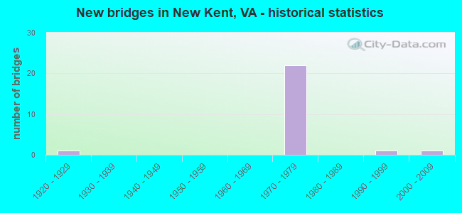
- New bridges - historical statistics
- 11920-1929
- 221970-1979
- 11990-1999
- 12000-2009


- Bridge Condition - Deck
- 8.3%Very good
- 25.0%Good
- 58.3%Satisfactory
- 8.3%Fair

- Bridge Condition - Superstructure
- 8.3%Very good
- 8.3%Good
- 16.7%Satisfactory
- 66.7%Fair

- Bridge Condition - Substructure
- 8.3%Very good
- 8.3%Good
- 50.0%Satisfactory
- 33.3%Fair

- Bridge Condition - Channel
- 14.3%Very good
- 14.3%Satisfactory
- 71.4%Fair
Find on map >> Show street view
Structure Number: 12635, Location: .5 Fr 64EBL & 0.62 To 632 (Lat: 37.477433, Lng: -76.918578), Route carried "on" structure: State highway 33, Year Built: 1971, Status: Open, Structure Length: 6.07m (19.91ft), Average Daily Traffic: 3,940 (year 2020), Truck Traffic: 15%, Average Future Daily Traffic: 5,516 (year 2040), Design Load: HS 20+Mod, Features Intersected: RTE I 64 EBL, Facility Carried by Structure: EBL ELTHAM ROAD
Minimum Vertical Clearance: 30+ m (98+ ft), Kilometerpoint: 51.198, Lanes on structure: 2, Lanes under structure: 2, Base Highway Network: Yes, Owner: State Highway Agency, Approaching Roadway Width: 15.2m (49.9ft), Skew: 2 degrees, Material/Design: Steel, Design/Construction: Stringer/Multi-beam, Number Of Spans In Main Unit: 3, Length of Maximum Span: 31.1m (102.0ft), Curb-To-Curb Width: 12.2m (40.0ft), Out-to-Out Width: 13.4m (44.0ft)
Condition: Deck: Good, Superstructure: Fair, Substructure: Satisfactory, Operating Rating: 60.8 metric tons, Method Used To Determine Operating Rating: Load and Resistance Factor (LRFR), Inventory Rating: 47.2 metric tons, Method Used To Determine Inventory Rating: Load and Resistance Factor (LRFR), Structural Evaluation: Somewhat better than minimum adequacy, Deck Geometry: Better than present minimum criteria, Underclear: Somewhat better than minimum adequacy, Approach Roadway Alignment: Equal to present minimum criteria, Designated Inspection Frequency: Every 24 months, Inspection Date: Febuary 2022, Deck Structure Type: Concrete Cast-file-Place
Find on map >> Show street view
Structure Number: 12661, Location: .5 FR I-64 (Lat: 37.479575, Lng: -76.917831), Route carried "on" structure: Ramp Interstate 33, Year Built: 1971, Status: Open, Structure Length: 5.75m (18.86ft), Average Daily Traffic: 866 (year 2020), Average Future Daily Traffic: 1,212 (year 2040), Design Load: HS 20+Mod, Features Intersected: RTE I 64 WBL
Minimum Vertical Clearance: 30+ m (98+ ft), Kilometerpoint: 0.290, Lanes on structure: 1, Lanes under structure: 2, Base Highway Network: Yes, Owner: State Highway Agency, Approaching Roadway Width: 9.8m (32.2ft), Skew: 2 degrees, Material/Design: Steel, Design/Construction: Stringer/Multi-beam, Number Of Spans In Main Unit: 3, Length of Maximum Span: 29.9m (98.1ft), Curb-To-Curb Width: 8.5m (27.9ft), Out-to-Out Width: 9.8m (32.2ft)
Condition: Deck: Satisfactory, Superstructure: Fair, Substructure: Satisfactory, Operating Rating: 65.3 metric tons, Method Used To Determine Operating Rating: Load and Resistance Factor (LRFR), Inventory Rating: 49.9 metric tons, Method Used To Determine Inventory Rating: Load and Resistance Factor (LRFR), Structural Evaluation: Somewhat better than minimum adequacy, Deck Geometry: Superior to present desirable criteria, Underclear: Somewhat better than minimum adequacy, Approach Roadway Alignment: Equal to present minimum criteria, Designated Inspection Frequency: Every 24 months, Inspection Date: Febuary 2022, Deck Structure Type: Concrete Cast-file-Place
Find on map >> Show street view
Structure Number: 12663, Location: 0.3 FR 64 & 0.3 TO 33 WBL (Lat: 37.478358, Lng: -76.919369), Route carried "on" structure: Ramp Interstate 33, Year Built: 1971, Status: Open, Structure Length: 6.24m (20.47ft), Average Daily Traffic: 866 (year 2020), Average Future Daily Traffic: 1,212 (year 2040), Design Load: HS 20+Mod, Features Intersected: I-64 EBL
Minimum Vertical Clearance: 30+ m (98+ ft), Kilometerpoint: 0.579, Lanes on structure: 1, Lanes under structure: 3, Base Highway Network: Yes, Owner: State Highway Agency, Approaching Roadway Width: 9.8m (32.2ft), Skew: 2 degrees, Material/Design: Steel, Design/Construction: Stringer/Multi-beam, Number Of Spans In Main Unit: 3, Length of Maximum Span: 34.1m (111.9ft), Curb-To-Curb Width: 8.5m (27.9ft), Out-to-Out Width: 9.8m (32.2ft)
Condition: Deck: Satisfactory, Superstructure: Fair, Substructure: Fair, Operating Rating: 62.6 metric tons, Method Used To Determine Operating Rating: Load and Resistance Factor (LRFR), Inventory Rating: 48.1 metric tons, Method Used To Determine Inventory Rating: Load and Resistance Factor (LRFR), Structural Evaluation: Somewhat better than minimum adequacy, Deck Geometry: Superior to present desirable criteria, Underclear: Somewhat better than minimum adequacy, Approach Roadway Alignment: Equal to present minimum criteria, Designated Inspection Frequency: Every 24 months, Inspection Date: Febuary 2022, Deck Structure Type: Concrete Cast-file-Place
Find on map >> Show street view
Structure Number: 12665, Location: 4.95 FR 155 & 0.51 TO 33 (Lat: 37.482189, Lng: -76.935106), Route carried "on" structure: Interstate 64, Year Built: 1971, Status: Open, Structure Length: 4.18m (13.71ft), Average Daily Traffic: 24,807 (year 2020), Truck Traffic: 9%, Average Future Daily Traffic: 34,730 (year 2040), Design Load: HS 20+Mod, Features Intersected: GOOD HOPE ROAD
Minimum Vertical Clearance: 30+ m (98+ ft), Kilometerpoint: 353.803, Lanes on structure: 2, Lanes under structure: 2, Base Highway Network: Yes, Owner: State Highway Agency, Approaching Roadway Width: 12.8m (42.0ft), Skew: 2 degrees, Material/Design: Steel, Design/Construction: Stringer/Multi-beam, Number Of Spans In Main Unit: 3, Length of Maximum Span: 16.5m (54.1ft), Curb-To-Curb Width: 12.2m (40.0ft), Out-to-Out Width: 13.4m (44.0ft)
Condition: Deck: Satisfactory, Superstructure: Fair, Substructure: Fair, Operating Rating: 51.6 metric tons, Method Used To Determine Operating Rating: Load and Resistance Factor (LRFR), Inventory Rating: 39.8 metric tons, Method Used To Determine Inventory Rating: Load and Resistance Factor (LRFR), Structural Evaluation: Somewhat better than minimum adequacy, Deck Geometry: Better than present minimum criteria, Underclear: Meets minimum limits, Approach Roadway Alignment: Equal to present desirable criteria, Length Of Structure Improvement: 4.11m (13.48ft), Designated Inspection Frequency: Every 24 months, Inspection Date: March 2021, Bridge Improvement Cost: $150,000, Roadway Improvement Cost: $15,000, Total Project Cost: $170,000 ( Estimate for 2014), Deck Structure Type: Concrete Cast-file-Place
Find on map >> Show street view
Structure Number: 12667, Location: 4.95 FR 155 & 0.71 TO 33 (Lat: 37.482986, Lng: -76.935197), Route carried "on" structure: Interstate 64, Year Built: 1971, Status: Open, Structure Length: 4.01m (13.16ft), Average Daily Traffic: 27,843 (year 2020), Truck Traffic: 9%, Average Future Daily Traffic: 38,980 (year 2040), Design Load: HS 20+Mod, Features Intersected: GOOD HOPE ROAD
Minimum Vertical Clearance: 30+ m (98+ ft), Kilometerpoint: 353.706, Lanes on structure: 2, Lanes under structure: 2, Base Highway Network: Yes, Owner: State Highway Agency, Approaching Roadway Width: 12.8m (42.0ft), Skew: 1 degrees, Material/Design: Steel, Design/Construction: Stringer/Multi-beam, Number Of Spans In Main Unit: 3, Length of Maximum Span: 16.0m (52.5ft), Curb-To-Curb Width: 12.2m (40.0ft), Out-to-Out Width: 13.4m (44.0ft)
Condition: Deck: Satisfactory, Superstructure: Fair, Substructure: Satisfactory, Operating Rating: 51.3 metric tons, Method Used To Determine Operating Rating: Load and Resistance Factor (LRFR), Inventory Rating: 39.6 metric tons, Method Used To Determine Inventory Rating: Load and Resistance Factor (LRFR), Structural Evaluation: Somewhat better than minimum adequacy, Deck Geometry: Better than present minimum criteria, Underclear: Meets minimum limits, Approach Roadway Alignment: Equal to present desirable criteria, Length Of Structure Improvement: 3.96m (12.99ft), Designated Inspection Frequency: Every 24 months, Inspection Date: March 2021, Bridge Improvement Cost: $150,000, Roadway Improvement Cost: $10,000, Total Project Cost: $170,000 ( Estimate for 2014), Deck Structure Type: Concrete Cast-file-Place
Find on map >> Show street view
Structure Number: 12669, Location: 3.44 TO 106 & 5.83 TO 33 (Lat: 37.495111, Lng: -77.023992), Route carried "on" structure: Interstate 64, Year Built: 1972, Status: Open, Structure Length: 4.48m (14.70ft), Average Daily Traffic: 28,404 (year 2020), Truck Traffic: 10%, Average Future Daily Traffic: 39,766 (year 2040), Design Load: HS 20+Mod, Features Intersected: RTE 155_(N. COURTHOUSE)
Minimum Vertical Clearance: 30+ m (98+ ft), Kilometerpoint: 345.806, Lanes on structure: 2, Lanes under structure: 2, Base Highway Network: Yes, Owner: State Highway Agency, Approaching Roadway Width: 16.5m (54.1ft), Skew: 1 degrees, Material/Design: Prestressed concrete, Design/Construction: Stringer/Multi-beam, Number Of Spans In Main Unit: 3, Length of Maximum Span: 19.9m (65.3ft), Curb-To-Curb Width: 12.2m (40.0ft), Out-to-Out Width: 13.4m (44.0ft)
Condition: Deck: Satisfactory, Superstructure: Fair, Substructure: Fair, Operating Rating: 79.4 metric tons, Method Used To Determine Operating Rating: Load and Resistance Factor (LRFR), Inventory Rating: 54.9 metric tons, Method Used To Determine Inventory Rating: Load and Resistance Factor (LRFR), Structural Evaluation: Somewhat better than minimum adequacy, Deck Geometry: Better than present minimum criteria, Underclear: Meets minimum limits, Approach Roadway Alignment: Equal to present desirable criteria, Designated Inspection Frequency: Every 24 months, Inspection Date: June 2021, Deck Structure Type: Concrete Cast-file-Place
Find on map >> Show street view
Structure Number: 12671, Location: 3.45 TO 106 & 5.76 TO 33 (Lat: 37.495775, Lng: -77.023572), Route carried "on" structure: Interstate 64, Year Built: 1972, Status: Open, Structure Length: 4.48m (14.70ft), Average Daily Traffic: 28,857 (year 2020), Truck Traffic: 10%, Average Future Daily Traffic: 40,400 (year 2040), Design Load: HS 20+Mod, Features Intersected: RTE 155_(N. COURTHOUSE)
Minimum Vertical Clearance: 30+ m (98+ ft), Kilometerpoint: 345.694, Lanes on structure: 2, Lanes under structure: 3, Base Highway Network: Yes, Owner: State Highway Agency, Approaching Roadway Width: 16.5m (54.1ft), Skew: 1 degrees, Material/Design: Prestressed concrete, Design/Construction: Stringer/Multi-beam, Number Of Spans In Main Unit: 3, Length of Maximum Span: 19.9m (65.3ft), Curb-To-Curb Width: 12.2m (40.0ft), Out-to-Out Width: 13.4m (44.0ft)
Condition: Deck: Satisfactory, Superstructure: Fair, Substructure: Fair, Operating Rating: 79.4 metric tons, Method Used To Determine Operating Rating: Load and Resistance Factor (LRFR), Inventory Rating: 54.9 metric tons, Method Used To Determine Inventory Rating: Load and Resistance Factor (LRFR), Structural Evaluation: Somewhat better than minimum adequacy, Deck Geometry: Better than present minimum criteria, Underclear: Meets minimum limits, Approach Roadway Alignment: Equal to present desirable criteria, Designated Inspection Frequency: Every 24 months, Inspection Date: June 2021, Deck Structure Type: Concrete Cast-file-Place
Find on map >> Show street view
Structure Number: 1269, Location: 1.47 fr 155 & 4.36 to 33 (Lat: 37.492211, Lng: -76.997047), Route carried "on" structure: Interstate 64, Year Built: 1972, Status: Open, Structure Length: 0.64m (2.10ft), Average Daily Traffic: 27,843 (year 2020), Truck Traffic: 9%, Average Future Daily Traffic: 38,980 (year 2040), Design Load: HS 20, Features Intersected: DIASCUND CREEK
Minimum Vertical Clearance: 30+ m (98+ ft), Kilometerpoint: 348.107, Lanes on structure: 2, Base Highway Network: Yes, Owner: State Highway Agency, Approaching Roadway Width: 11.9m (39.0ft), Skew: 1 degrees, Material/Design: Concrete, Design/Construction: Culvert, Number Of Spans In Main Unit: 2, Length of Maximum Span: 3.0m (9.8ft)
Condition: Channel: Fair, Culverts: Fair, Operating Rating: 89.8 metric tons, Method Used To Determine Operating Rating: Field evaluation and documented engineering judgment, Inventory Rating: 89.8 metric tons, Method Used To Determine Inventory Rating: Field evaluation and documented engineering judgment, Structural Evaluation: Somewhat better than minimum adequacy, Waterway Adequacy: Equal to present desirable criteria, Approach Roadway Alignment: Equal to present desirable criteria, Designated Inspection Frequency: Every 24 months, Inspection Date: January 2021
Find on map >> Show street view
Structure Number: 12691, Location: 1.47 fr 155 & 4.36 to 33 (Lat: 37.491669, Lng: -76.997094), Route carried "on" structure: Interstate 64, Year Built: 1972, Status: Open, Structure Length: 0.64m (2.10ft), Average Daily Traffic: 28,404 (year 2020), Truck Traffic: 9%, Average Future Daily Traffic: 39,766 (year 2040), Design Load: HS 20, Features Intersected: DIASCUND CREEK
Minimum Vertical Clearance: 30+ m (98+ ft), Kilometerpoint: 348.204, Lanes on structure: 2, Base Highway Network: Yes, Owner: State Highway Agency, Approaching Roadway Width: 11.9m (39.0ft), Skew: 1 degrees, Material/Design: Concrete, Design/Construction: Culvert, Number Of Spans In Main Unit: 2, Length of Maximum Span: 3.0m (9.8ft)
Condition: Channel: Fair, Culverts: Fair, Operating Rating: 89.8 metric tons, Method Used To Determine Operating Rating: Field evaluation and documented engineering judgment, Inventory Rating: 89.8 metric tons, Method Used To Determine Inventory Rating: Field evaluation and documented engineering judgment, Structural Evaluation: Somewhat better than minimum adequacy, Waterway Adequacy: Equal to present desirable criteria, Approach Roadway Alignment: Equal to present desirable criteria, Designated Inspection Frequency: Every 24 months, Inspection Date: January 2021
Find on map >> Show street view
Structure Number: 12696, Location: 2.51 fr 106 & 0.93 to 155 (Lat: 37.497986, Lng: -77.040189), Route carried "on" structure: Interstate 64, Year Built: 1972, Status: Open, Structure Length: 0.64m (2.10ft), Average Daily Traffic: 28,857 (year 2020), Truck Traffic: 9%, Average Future Daily Traffic: 40,400 (year 2040), Design Load: HS 20, Features Intersected: RUMLEY MARSH
Minimum Vertical Clearance: 30+ m (98+ ft), Kilometerpoint: 344.250, Lanes on structure: 2, Base Highway Network: Yes, Owner: State Highway Agency, Approaching Roadway Width: 11.9m (39.0ft), Material/Design: Concrete, Design/Construction: Culvert, Number Of Spans In Main Unit: 2, Length of Maximum Span: 3.0m (9.8ft)
Condition: Channel: Fair, Culverts: Fair, Operating Rating: 89.8 metric tons, Method Used To Determine Operating Rating: Field evaluation and documented engineering judgment, Inventory Rating: 89.8 metric tons, Method Used To Determine Inventory Rating: Field evaluation and documented engineering judgment, Structural Evaluation: Somewhat better than minimum adequacy, Waterway Adequacy: Equal to present desirable criteria, Approach Roadway Alignment: Equal to present desirable criteria, Designated Inspection Frequency: Every 24 months, Inspection Date: January 2021
Find on map >> Show street view
Structure Number: 12697, Location: 2.51 fr 106 & 0.93 to 155 (Lat: 37.497189, Lng: -77.040206), Route carried "on" structure: Interstate 64, Year Built: 1972, Status: Open, Structure Length: 0.64m (2.10ft), Average Daily Traffic: 29,009 (year 2020), Truck Traffic: 9%, Average Future Daily Traffic: 40,613 (year 2040), Design Load: HS 20, Features Intersected: RUMLEY MARSH
Minimum Vertical Clearance: 30+ m (98+ ft), Kilometerpoint: 344.347, Lanes on structure: 2, Base Highway Network: Yes, Owner: State Highway Agency, Approaching Roadway Width: 11.9m (39.0ft), Material/Design: Concrete, Design/Construction: Culvert, Number Of Spans In Main Unit: 2, Length of Maximum Span: 3.1m (10.2ft)
Condition: Channel: Fair, Culverts: Fair, Operating Rating: 89.8 metric tons, Method Used To Determine Operating Rating: Field evaluation and documented engineering judgment, Inventory Rating: 89.8 metric tons, Method Used To Determine Inventory Rating: Field evaluation and documented engineering judgment, Structural Evaluation: Somewhat better than minimum adequacy, Waterway Adequacy: Equal to present desirable criteria, Approach Roadway Alignment: Equal to present desirable criteria, Designated Inspection Frequency: Every 24 months, Inspection Date: January 2021
Find on map >> Show street view
Structure Number: 12708, Location: 2.42 TO 155 & 8.00 TO I64 (Lat: 37.524114, Lng: -77.051986), Route carried "on" structure: State highway 249, Year Built: 1924, Status: Open, Structure Length: 0.69m (2.26ft), Average Daily Traffic: 2,654 (year 2020), Truck Traffic: 5%, Average Future Daily Traffic: 3,017 (year 2040), Design Load: H 15, Features Intersected: PELHAM SWAMP, Facility Carried by Structure: NEW KENT HIGHWAY
Minimum Vertical Clearance: 30+ m (98+ ft), Kilometerpoint: 12.737, Lanes on structure: 2, Owner: State Highway Agency, Approaching Roadway Width: 7.9m (25.9ft), Material/Design: Concrete, Design/Construction: Slab, Number Of Spans In Main Unit: 1, Length of Maximum Span: 6.5m (21.3ft), Curb-To-Curb Width: 10.3m (33.8ft), Out-to-Out Width: 11.5m (37.7ft)
Condition: Deck: Fair, Superstructure: Fair, Substructure: Satisfactory, Channel: Satisfactory, Operating Rating: 53.1 metric tons, Method Used To Determine Operating Rating: Allowable Stress (AS), Inventory Rating: 27.9 metric tons, Method Used To Determine Inventory Rating: Allowable Stress (AS), Structural Evaluation: Somewhat better than minimum adequacy, Deck Geometry: Meets minimum limits, Waterway Adequacy: Equal to present desirable criteria, Approach Roadway Alignment: Equal to present desirable criteria, Designated Inspection Frequency: Every 24 months, Inspection Date: September 2020, Deck Structure Type: Concrete Cast-file-Place, Wearing Surface/Protective System: Wearing Surface: Bituminous
Find on map >> Show street view
Structure Number: 12723, Location: 0.25 TO 677 & 0.05 TO 617 (Lat: 37.499150, Lng: -77.057506), Route carried "on" structure: County highway 618, Year Built: 1972, Status: Open, Structure Length: 5.52m (18.11ft), Average Daily Traffic: 489 (year 2014), Average Future Daily Traffic: 743 (year 2040), Design Load: HS 20+Mod, Features Intersected: RTE I 64 & 33 EBL, Facility Carried by Structure: OLIVET CHURCH ROAD
Minimum Vertical Clearance: 30+ m (98+ ft), Kilometerpoint: 8.779, Lanes on structure: 2, Lanes under structure: 2, Owner: State Highway Agency, Approaching Roadway Width: 8.5m (27.9ft), Material/Design: Steel, Design/Construction: Stringer/Multi-beam, Number Of Spans In Main Unit: 3, Length of Maximum Span: 28.7m (94.2ft), Curb or Sidewalk Widths: Left: 0.2m (0.7ft), Right: 0.2m (0.7ft), Curb-To-Curb Width: 8.1m (26.6ft), Out-to-Out Width: 9.3m (30.5ft)
Condition: Deck: Good, Superstructure: Satisfactory, Substructure: Satisfactory, Operating Rating: 74.4 metric tons, Method Used To Determine Operating Rating: Load and Resistance Factor (LRFR), Inventory Rating: 57.2 metric tons, Method Used To Determine Inventory Rating: Load and Resistance Factor (LRFR), Structural Evaluation: Equal to present minimum criteria, Deck Geometry: Somewhat better than minimum adequacy, Underclear: Better than present minimum criteria, Approach Roadway Alignment: Equal to present desirable criteria, Designated Inspection Frequency: Every 24 months, Inspection Date: Febuary 2022, Deck Structure Type: Concrete Cast-file-Place
Find on map >> Show street view
Structure Number: 12725, Location: 0.25 TO 677 & 0.05 TO 617 (Lat: 37.499925, Lng: -77.057275), Route carried "on" structure: County highway 618, Year Built: 1972, Status: Open, Structure Length: 5.52m (18.11ft), Average Daily Traffic: 489 (year 2014), Average Future Daily Traffic: 743 (year 2040), Design Load: HS 20+Mod, Features Intersected: RTES I 64 & 33 WBL, Facility Carried by Structure: OLIVET CHURCH ROAD
Minimum Vertical Clearance: 30+ m (98+ ft), Kilometerpoint: 8.779, Lanes on structure: 2, Lanes under structure: 2, Owner: State Highway Agency, Approaching Roadway Width: 8.5m (27.9ft), Material/Design: Steel, Design/Construction: Stringer/Multi-beam, Number Of Spans In Main Unit: 3, Length of Maximum Span: 28.0m (91.9ft), Curb or Sidewalk Widths: Left: 0.2m (0.7ft), Right: 0.2m (0.7ft), Curb-To-Curb Width: 8.1m (26.6ft), Out-to-Out Width: 9.3m (30.5ft)
Condition: Deck: Good, Superstructure: Satisfactory, Substructure: Satisfactory, Operating Rating: 75.3 metric tons, Method Used To Determine Operating Rating: Load and Resistance Factor (LRFR), Inventory Rating: 58.1 metric tons, Method Used To Determine Inventory Rating: Load and Resistance Factor (LRFR), Structural Evaluation: Equal to present minimum criteria, Deck Geometry: Somewhat better than minimum adequacy, Underclear: Better than present minimum criteria, Approach Roadway Alignment: Equal to present desirable criteria, Designated Inspection Frequency: Every 24 months, Inspection Date: Febuary 2022, Deck Structure Type: Concrete Cast-file-Place
Find on map >> Show street view
Structure Number: 25675, Location: 1.5M RTE 651-0.5M RTE 630 (Lat: 37.581569, Lng: -76.948064), Route carried "on" structure: County highway 632, Year Built: 1999, Status: Open, Structure Length: 2.56m (8.40ft), Average Daily Traffic: 153 (year 2019), Average Future Daily Traffic: 169 (year 2040), Design Load: HS 20+Mod, Features Intersected: COHOKE MILL PD SPILLWAY, Facility Carried by Structure: MT. OLIVE/COHOKE R
Minimum Vertical Clearance: 30+ m (98+ ft), Kilometerpoint: 4.988, Lanes on structure: 2, Owner: State Highway Agency, Approaching Roadway Width: 7.0m (23.0ft), Material/Design: Steel, Design/Construction: Stringer/Multi-beam, Number Of Spans In Main Unit: 1, Length of Maximum Span: 25.0m (82.0ft), Curb-To-Curb Width: 7.2m (23.6ft), Out-to-Out Width: 7.8m (25.6ft)
Condition: Deck: Very good, Superstructure: Very good, Substructure: Very good, Channel: Very good, Operating Rating: 78.4 metric tons, Method Used To Determine Operating Rating: Load and Resistance Factor (LRFR), Inventory Rating: 60.4 metric tons, Method Used To Determine Inventory Rating: Load and Resistance Factor (LRFR), Structural Evaluation: Equal to present desirable criteria, Deck Geometry: Meets minimum limits, Waterway Adequacy: Equal to present desirable criteria, Approach Roadway Alignment: Equal to present desirable criteria, Designated Inspection Frequency: Every 24 months, Inspection Date: March 2021, Deck Structure Type: Concrete Cast-file-Place
Find on map >> Show street view
Structure Number: 26852, Location: 4.40 FR 60 & 2.20 TO 627 (Lat: 37.483814, Lng: -76.946261), Route carried "on" structure: County highway 628, Year Built: 2001, Status: Open, Structure Length: 1.62m (5.31ft), Average Daily Traffic: 100 (year 2020), Average Future Daily Traffic: 110 (year 2040), Design Load: HS 20+Mod, Features Intersected: DIASCUND CREEK, Facility Carried by Structure: MT. PLEASANT ROAD
Minimum Vertical Clearance: 30+ m (98+ ft), Kilometerpoint: 9.294, Lanes on structure: 2, Owner: State Highway Agency, Approaching Roadway Width: 6.7m (22.0ft), Material/Design: Steel, Design/Construction: Stringer/Multi-beam, Number Of Spans In Main Unit: 1, Length of Maximum Span: 15.2m (49.9ft), Curb-To-Curb Width: 7.3m (24.0ft), Out-to-Out Width: 7.3m (24.0ft)
Condition: Deck: Satisfactory, Superstructure: Good, Substructure: Good, Channel: Fair, Operating Rating: 58.1 metric tons, Method Used To Determine Operating Rating: Load and Resistance Factor (LRFR), Inventory Rating: 45.4 metric tons, Method Used To Determine Inventory Rating: Load and Resistance Factor (LRFR), Structural Evaluation: Better than present minimum criteria, Deck Geometry: Equal to present minimum criteria, Waterway Adequacy: Better than present minimum criteria, Approach Roadway Alignment: Equal to present minimum criteria, Designated Inspection Frequency: Every 24 months, Inspection Date: July 2021, Deck Structure Type: Corrugated Steel, Wearing Surface/Protective System: Wearing Surface: Bituminous
Find on map >> Show street view
Structure Number: 12635, Location: .5 Fr 64EBL & 0.62 To 632 (Lat: 37.477433, Lng: -76.918578), Route carried "under" structure: Interstate 64, Year Built: 1971, Structure Length: 0. m, Average Daily Traffic: 46,751 (year 2008), Truck Traffic: 4%, Features Intersected: RTE I 64 EBL, Facility Carried by Structure: EBL ELTHAM ROAD
Minimum Vertical Clearance: 4.93m (16.17ft), Kilometerpoint: 355.348, Lanes on structure: 2, Lanes under structure: 2, Material/Design: Steel, Design/Construction: Stringer/Multi-beam, Length of Maximum Span: 31.1m (102.0ft)
Find on map >> Show street view
Structure Number: 12661, Location: .5 FR I-64 (Lat: 37.479575, Lng: -76.917831), Route carried "under" structure: Interstate 64, Year Built: 1971, Structure Length: 0. m, Average Daily Traffic: 15,053 (year 1994), Features Intersected: RTE I 64 WBL, Facility Carried by Structure: RAMP RTE 33 WBL
Minimum Vertical Clearance: 5.05m (16.57ft), Kilometerpoint: 355.106, Lanes on structure: 1, Lanes under structure: 2, Material/Design: Steel, Design/Construction: Stringer/Multi-beam, Length of Maximum Span: 29.9m (98.1ft)
Find on map >> Show street view
Structure Number: 12663, Location: 0.3 FR 64 & 0.3 TO 33 WBL (Lat: 37.478358, Lng: -76.919369), Route carried "under" structure: Interstate 64, Year Built: 1971, Structure Length: 0. m, Average Daily Traffic: 46,751 (year 2008), Truck Traffic: 4%, Features Intersected: I-64 EBL, Facility Carried by Structure: RAMP FR 33 WBL
Minimum Vertical Clearance: 4.95m (16.24ft), Kilometerpoint: 355.203, Lanes on structure: 1, Lanes under structure: 3, Material/Design: Steel, Design/Construction: Stringer/Multi-beam, Length of Maximum Span: 34.1m (111.9ft)
Find on map >> Show street view
Structure Number: 12665, Location: 4.95 FR 155 & 0.51 TO 33 (Lat: 37.482189, Lng: -76.935106), Route carried "under" structure: County highway 627, Year Built: 1971, Structure Length: 0. m, Average Daily Traffic: 784 (year 2008), Features Intersected: GOOD HOPE ROAD, Facility Carried by Structure: EBL I-64
Minimum Vertical Clearance: 5.08m (16.67ft), Kilometerpoint: 13.612, Lanes on structure: 2, Lanes under structure: 2, Material/Design: Steel, Design/Construction: Stringer/Multi-beam, Length of Maximum Span: 16.5m (54.1ft)
Find on map >> Show street view
Structure Number: 12667, Location: 4.95 FR 155 & 0.71 TO 33 (Lat: 37.482986, Lng: -76.935197), Route carried "under" structure: County highway 627, Year Built: 1971, Structure Length: 0. m, Average Daily Traffic: 784 (year 2008), Features Intersected: GOOD HOPE ROAD, Facility Carried by Structure: WBL I-64
Minimum Vertical Clearance: 4.90m (16.08ft), Kilometerpoint: 13.644, Lanes on structure: 2, Lanes under structure: 2, Material/Design: Steel, Design/Construction: Stringer/Multi-beam, Length of Maximum Span: 16.0m (52.5ft)
Find on map >> Show street view
Structure Number: 12669, Location: 3.44 TO 106 & 5.83 TO 33 (Lat: 37.495111, Lng: -77.023992), Route carried "under" structure: State highway 155, Year Built: 1972, Structure Length: 0. m, Average Daily Traffic: 3,300 (year 2020), Truck Traffic: 4%, Features Intersected: RTE 155_(N. COURTHOUSE), Facility Carried by Structure: EBL ROUTE 0064
Minimum Vertical Clearance: 5.05m (16.57ft), Kilometerpoint: 18.343, Lanes on structure: 2, Lanes under structure: 2, Material/Design: Prestressed concrete, Design/Construction: Stringer/Multi-beam, Length of Maximum Span: 19.9m (65.3ft)
Find on map >> Show street view
Structure Number: 12671, Location: 3.45 TO 106 & 5.76 TO 33 (Lat: 37.495775, Lng: -77.023572), Route carried "under" structure: State highway 155, Year Built: 1972, Structure Length: 0. m, Average Daily Traffic: 3,300 (year 2020), Truck Traffic: 4%, Features Intersected: RTE 155_(N. COURTHOUSE), Facility Carried by Structure: WBL ROUTE 0064
Minimum Vertical Clearance: 5.08m (16.67ft), Kilometerpoint: 18.423, Lanes on structure: 2, Lanes under structure: 3, Material/Design: Prestressed concrete, Design/Construction: Stringer/Multi-beam, Length of Maximum Span: 19.9m (65.3ft)
Find on map >> Show street view
Structure Number: 12723, Location: 0.25 TO 677 & 0.05 TO 617 (Lat: 37.499150, Lng: -77.057506), Route carried "under" structure: Interstate 64, Year Built: 1972, Structure Length: 0. m, Average Daily Traffic: 59,383 (year 2008), Truck Traffic: 4%, Features Intersected: RTE I 64 & 33 EBL, Facility Carried by Structure: OLIVET CHURCH ROAD
Minimum Vertical Clearance: 5.36m (17.59ft), Kilometerpoint: 342.814, Lanes on structure: 2, Lanes under structure: 2, Material/Design: Steel, Design/Construction: Stringer/Multi-beam, Length of Maximum Span: 28.7m (94.2ft)
Find on map >> Show street view
Structure Number: 12725, Location: 0.25 TO 677 & 0.05 TO 617 (Lat: 37.499925, Lng: -77.057275), Route carried "under" structure: Interstate 64, Year Built: 1972, Structure Length: 0. m, Average Daily Traffic: 40,000 (year 1994), Features Intersected: RTES I 64 & 33 WBL, Facility Carried by Structure: OLIVET CHURCH ROAD
Minimum Vertical Clearance: 5.31m (17.42ft), Kilometerpoint: 342.733, Lanes on structure: 2, Lanes under structure: 2, Material/Design: Steel, Design/Construction: Stringer/Multi-beam, Length of Maximum Span: 28.0m (91.9ft)