Bridge Statistics for New Paris, Pennsylvania (PA)
Condition, Traffic, Stress, Structural Evaluation, Project Costs
- National Bridge Inventory (NBI) Statistics
- 11Number of bridges
- 59ft / 18.1mTotal length
- $4,142,000Total costs
- 4,277Total average daily traffic
- 366Total average daily truck traffic
- 6,131Total future (year 2032) average daily traffic
- National Bridge Inventory (NBI) Registered Bridges for New Paris
- No street view available for this location
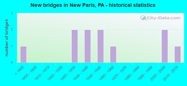
- New bridges - historical statistics
- 1Before 1900
- 21930-1939
- 21940-1949
- 21950-1959
- 11960-1969
- 22000-2009
- 12010-2019

- Reconstructed bridges - Historical Statistics
- 21990-1999
- 32000-2009
- 12010-2019

- Bridge Condition - Deck
- 9.1%Very good
- 63.6%Good
- 9.1%Satisfactory
- 18.2%Fair

- Bridge Condition - Superstructure
- 18.2%Very good
- 27.3%Good
- 27.3%Satisfactory
- 27.3%Fair

- Bridge Condition - Substructure
- 18.2%Very good
- 45.5%Good
- 18.2%Satisfactory
- 18.2%Fair

- Bridge Condition - Channel
- 27.3%Good
- 18.2%Satisfactory
- 36.4%Fair
- 18.2%Poor
Find on map >> Show street view
Structure Number: 4054, Location: 0.8 MI.S.OF NEW PARIS (Lat: 40.097603, Lng: -78.652161), Route carried "on" structure: State highway 96, Year Built: 1956, Year Reconstructed: 2007, Status: Open, Structure Length: 0.98m (3.22ft), Average Daily Traffic: 1,489 (year 2020), Truck Traffic: 9%, Average Future Daily Traffic: 2,093 (year 2032), Design Load: HS 20, Features Intersected: BETHEL HOLLOW RUN
Minimum Vertical Clearance: 30+ m (98+ ft), Kilometerpoint: 47.101, Lanes on structure: 2, Owner: State Highway Agency, Approaching Roadway Width: 8.2m (26.9ft), Skew: 4 degrees, Material/Design: Prestressed concrete, Design/Construction: Box Beam or Girders - Multiple, Number Of Spans In Main Unit: 1, Length of Maximum Span: 8.8m (28.9ft), Curb or Sidewalk Widths: Left: 0.1m (0.3ft), Right: 0.1m (0.3ft), Curb-To-Curb Width: 9.6m (31.5ft), Out-to-Out Width: 10.5m (34.4ft)
Condition: Deck: Good, Superstructure: Satisfactory, Substructure: Satisfactory, Channel: Fair, Inventory Rating: 69.9 metric tons, Method Used To Determine Inventory Rating: Load Factor (LF), Structural Evaluation: Equal to present minimum criteria, Deck Geometry: Somewhat better than minimum adequacy, Waterway Adequacy: Equal to present minimum criteria, Approach Roadway Alignment: Equal to present desirable criteria, Length Of Structure Improvement: 1.60m (5.25ft), Designated Inspection Frequency: Every 48 months, Inspection Date: March 2020, Deck Structure Type: Concrete Cast-file-Place, Wearing Surface/Protective System: Wearing Surface: Monolithic Concrete, Deck Protection: Epoxy Coated Reinforcing
Find on map >> Show street view
Structure Number: 4055, Location: 0.5 MI.N.OF NEW PARIS (Lat: 40.115681, Lng: -78.639847), Route carried "on" structure: State highway 96, Year Built: 1938, Year Reconstructed: 2007, Status: Open, Structure Length: 3.54m (11.61ft), Average Daily Traffic: 1,489 (year 2020), Truck Traffic: 9%, Average Future Daily Traffic: 2,093 (year 2032), Design Load: HS 20, Features Intersected: DUNNING CREEK
Minimum Vertical Clearance: 30+ m (98+ ft), Kilometerpoint: 49.032, Lanes on structure: 2, Owner: State Highway Agency, Approaching Roadway Width: 8.8m (28.9ft), Skew: 4 degrees, Material/Design: Prestressed concrete, Design/Construction: Box Beam or Girders - Multiple, Number Of Spans In Main Unit: 2, Length of Maximum Span: 17.1m (56.1ft), Curb-To-Curb Width: 10.2m (33.5ft), Out-to-Out Width: 11.1m (36.4ft)
Condition: Deck: Good, Superstructure: Fair, Substructure: Fair, Channel: Poor, Operating Rating: 91.6 metric tons, Method Used To Determine Operating Rating: Load Factor (LF), Inventory Rating: 29.0 metric tons, Method Used To Determine Inventory Rating: Load Factor (LF), Structural Evaluation: Somewhat better than minimum adequacy, Deck Geometry: Somewhat better than minimum adequacy, Waterway Adequacy: Equal to present desirable criteria, Approach Roadway Alignment: Better than present minimum criteria, Length Of Structure Improvement: 4.30m (14.11ft), Designated Inspection Frequency: Every 24 months, Inspection Date: March 2020, Deck Structure Type: Concrete Cast-file-Place, Wearing Surface/Protective System: Wearing Surface: Monolithic Concrete, Deck Protection: Epoxy Coated Reinforcing
Find on map >> Show street view
Structure Number: 4363, Location: 0.29 MILE WEST FROM PA 96 (Lat: 40.108858, Lng: -78.649333), Route carried "on" structure: State highway , Year Built: 1939, Year Reconstructed: 2009, Status: Open, Structure Length: 1.74m (5.71ft), Average Daily Traffic: 214 (year 2022), Truck Traffic: 9%, Average Future Daily Traffic: 285 (year 2032), Design Load: HL 93, Features Intersected: ROCKLICK CREEK, Facility Carried by Structure: SR 4018
Minimum Vertical Clearance: 30+ m (98+ ft), Kilometerpoint: 8.045, Lanes on structure: 2, Owner: State Highway Agency, Approaching Roadway Width: 6.4m (21.0ft), Skew: 4 degrees, Material/Design: Steel, Design/Construction: Stringer/Multi-beam, Number Of Spans In Main Unit: 1, Length of Maximum Span: 16.2m (53.1ft), Curb-To-Curb Width: 7.3m (24.0ft), Out-to-Out Width: 7.9m (25.9ft)
Condition: Deck: Good, Superstructure: Very good, Substructure: Very good, Channel: Satisfactory, Operating Rating: 70.8 metric tons, Method Used To Determine Operating Rating: Load and Resistance Factor (LRFR), Inventory Rating: 54.4 metric tons, Method Used To Determine Inventory Rating: Load and Resistance Factor (LRFR), Structural Evaluation: Equal to present desirable criteria, Deck Geometry: Somewhat better than minimum adequacy, Waterway Adequacy: Equal to present desirable criteria, Approach Roadway Alignment: Better than present minimum criteria, Length Of Structure Improvement: 2.00m (6.56ft), Designated Inspection Frequency: Every 24 months, Inspection Date: October 2021, Bridge Improvement Cost: $61,000, Roadway Improvement Cost: $264,000, Total Project Cost: $821,000, Deck Structure Type: Concrete Cast-file-Place, Wearing Surface/Protective System: Wearing Surface: Monolithic Concrete, Deck Protection: Epoxy Coated Reinforcing
Find on map >> Show street view
Structure Number: 4364, Location: NEW PARIS BORO (Lat: 40.106706, Lng: -78.646094), Route carried "on" structure: State highway , Year Built: 1948, Status: Open, Structure Length: 1.34m (4.40ft), Average Daily Traffic: 214 (year 2022), Truck Traffic: 9%, Average Future Daily Traffic: 285 (year 2032), Design Load: H 20, Features Intersected: DUNNINGS CREEK, Facility Carried by Structure: SR 4018
Minimum Vertical Clearance: 30+ m (98+ ft), Kilometerpoint: 8.045, Lanes on structure: 2, Owner: State Highway Agency, Approaching Roadway Width: 5.2m (17.1ft), Skew: 1 degrees, Material/Design: Concrete, Design/Construction: Tee Beam, Number Of Spans In Main Unit: 1, Length of Maximum Span: 12.8m (42.0ft), Curb or Sidewalk Widths: Left: 0.2m (0.7ft), Right: 0.2m (0.7ft), Curb-To-Curb Width: 7.5m (24.6ft), Out-to-Out Width: 8.4m (27.6ft)
Condition: Deck: Satisfactory, Superstructure: Fair, Substructure: Satisfactory, Channel: Poor, Operating Rating: 60.8 metric tons, Method Used To Determine Operating Rating: Load Factor (LF), Inventory Rating: 36.3 metric tons, Method Used To Determine Inventory Rating: Load Factor (LF), Structural Evaluation: Somewhat better than minimum adequacy, Deck Geometry: Somewhat better than minimum adequacy, Waterway Adequacy: Equal to present desirable criteria, Approach Roadway Alignment: Better than present minimum criteria, Length Of Structure Improvement: 1.70m (5.58ft), Designated Inspection Frequency: Every 24 months, Inspection Date: October 2021, Bridge Improvement Cost: $55,000, Roadway Improvement Cost: $264,000, Total Project Cost: $743,000, Deck Structure Type: Concrete Cast-file-Place, Wearing Surface/Protective System: Wearing Surface: Bituminous, Membrane: Preformed Fabric
Find on map >> Show street view
Structure Number: 4371, Location: 0.06 MILE WEST FROM PA 96 (Lat: 40.109517, Lng: -78.643406), Route carried "on" structure: State highway , Year Built: 1957, Year Reconstructed: 2010, Status: Open, Structure Length: 2.04m (6.69ft), Average Daily Traffic: 11 (year 2016), Truck Traffic: 9%, Average Future Daily Traffic: 46 (year 2040), Design Load: HS 20, Features Intersected: DUNNING CREEK, Facility Carried by Structure: SR 4020
Minimum Vertical Clearance: 30+ m (98+ ft), Kilometerpoint: 1.405, Lanes on structure: 2, Owner: State Highway Agency, Approaching Roadway Width: 8.2m (26.9ft), Material/Design: Prestressed concrete, Design/Construction: Box Beam or Girders - Multiple, Number Of Spans In Main Unit: 1, Length of Maximum Span: 20.1m (65.9ft), Curb-To-Curb Width: 8.6m (28.2ft), Out-to-Out Width: 9.2m (30.2ft)
Condition: Deck: Good, Superstructure: Satisfactory, Substructure: Good, Channel: Fair, Operating Rating: 94.3 metric tons, Method Used To Determine Operating Rating: Load Factor (LF), Inventory Rating: 38.1 metric tons, Method Used To Determine Inventory Rating: Load Factor (LF), Structural Evaluation: Equal to present minimum criteria, Deck Geometry: Better than present minimum criteria, Waterway Adequacy: Equal to present desirable criteria, Approach Roadway Alignment: Equal to present desirable criteria, Length Of Structure Improvement: 2.60m (8.53ft), Designated Inspection Frequency: Every 48 months, Inspection Date: January 2020, Bridge Improvement Cost: $70,000, Roadway Improvement Cost: $264,000, Total Project Cost: $947,000, Deck Structure Type: Concrete Cast-file-Place, Wearing Surface/Protective System: Wearing Surface: Monolithic Concrete, Deck Protection: Epoxy Coated Reinforcing
Find on map >> Show street view
Structure Number: 4372, Location: VILLAGE OF POINT (Lat: 40.086242, Lng: -78.603008), Route carried "on" structure: State highway , Year Built: 1965, Status: Open, Structure Length: 1.62m (5.31ft), Average Daily Traffic: 264 (year 2020), Truck Traffic: 10%, Average Future Daily Traffic: 455 (year 2040), Design Load: HS 20, Features Intersected: ADAMS RUN, Facility Carried by Structure: SR 4022
Minimum Vertical Clearance: 30+ m (98+ ft), Kilometerpoint: 0.893, Lanes on structure: 2, Owner: State Highway Agency, Approaching Roadway Width: 6.4m (21.0ft), Skew: 5 degrees, Material/Design: Prestressed concrete, Design/Construction: Box Beam or Girders - Single/Spread, Number Of Spans In Main Unit: 1, Length of Maximum Span: 15.8m (51.8ft), Curb or Sidewalk Widths: Left: 0.5m (1.6ft), Right: 0.5m (1.6ft), Curb-To-Curb Width: 9.1m (29.9ft), Out-to-Out Width: 10.8m (35.4ft)
Condition: Deck: Fair, Superstructure: Satisfactory, Substructure: Good, Channel: Fair, Operating Rating: 66.2 metric tons, Method Used To Determine Operating Rating: Load Factor (LF), Inventory Rating: 25.4 metric tons, Method Used To Determine Inventory Rating: Load Factor (LF), Structural Evaluation: Equal to present minimum criteria, Deck Geometry: Equal to present minimum criteria, Waterway Adequacy: Better than present minimum criteria, Approach Roadway Alignment: Equal to present desirable criteria, Length Of Structure Improvement: 2.30m (7.55ft), Designated Inspection Frequency: Every 24 months, Inspection Date: December 2021, Deck Structure Type: Concrete Cast-file-Place, Wearing Surface/Protective System: Wearing Surface: Monolithic Concrete
Find on map >> Show street view
Structure Number: 4487, Location: 2 MI.S.OF FISHERTOWN (Lat: 40.102653, Lng: -78.585839), Route carried "on" structure: City street , Year Built: 2003, Status: Open, Structure Length: 0.98m (3.22ft), Average Daily Traffic: 51 (year 2021), Average Future Daily Traffic: 66 (year 2041), Design Load: HS 25 or greater, Features Intersected: ADAMS RUN, Facility Carried by Structure: T-518,ADAMS RUN RD
Minimum Vertical Clearance: 30+ m (98+ ft), Kilometerpoint: 0.000, Lanes on structure: 2, Owner: Town or Township Highway Agency, Approaching Roadway Width: 7.6m (24.9ft), Material/Design: Prestressed concrete, Design/Construction: Slab, Number Of Spans In Main Unit: 1, Length of Maximum Span: 9.1m (29.9ft), Curb or Sidewalk Widths: Left: 0.2m (0.7ft), Right: 0.2m (0.7ft), Curb-To-Curb Width: 7.7m (25.3ft), Out-to-Out Width: 8.6m (28.2ft)
Condition: Deck: Good, Superstructure: Good, Substructure: Good, Channel: Satisfactory, Inventory Rating: 51.7 metric tons, Method Used To Determine Inventory Rating: Load Factor (LF), Structural Evaluation: Better than present minimum criteria, Deck Geometry: Equal to present minimum criteria, Waterway Adequacy: Equal to present minimum criteria, Approach Roadway Alignment: Better than present minimum criteria, Length Of Structure Improvement: 1.60m (5.25ft), Designated Inspection Frequency: Every 24 months, Inspection Date: April 2021, Deck Structure Type: Concrete Cast-file-Place, Wearing Surface/Protective System: Wearing Surface: Monolithic Concrete, Deck Protection: Epoxy Coated Reinforcing
Find on map >> Show street view
Structure Number: 4542, Location: 1 MI.E.OF RYOT (Lat: 40.142256, Lng: -78.624431), Route carried "on" structure: City street , Year Built: 1867, Year Reconstructed: 2004, Status: Posted for load, Structure Length: 2.62m (8.60ft), Average Daily Traffic: 60 (year 2021), Truck Traffic: 1%, Average Future Daily Traffic: 51 (year 2041), Design Load: H 10, Features Intersected: DUNNING CREEK, Facility Carried by Structure: T-549, Bowser Road
Minimum Vertical Clearance: 3.40m (11.15ft), Kilometerpoint: 0.000, Lanes on structure: 1, Owner: County Highway Agency, Approaching Roadway Width: 3.4m (11.2ft), Material/Design: Steel, Design/Construction: Stringer/Multi-beam, Number Of Spans In Main Unit: 1, Length of Maximum Span: 24.4m (80.1ft), Curb or Sidewalk Widths: Left: 0.1m (0.3ft), Right: 0.1m (0.3ft), Curb-To-Curb Width: 3.3m (10.8ft), Out-to-Out Width: 3.7m (12.1ft)
Condition: Deck: Good, Superstructure: Good, Substructure: Good, Channel: Good, Operating Rating: 44.5 metric tons, Method Used To Determine Operating Rating: Load Factor (LF), Inventory Rating: 29.0 metric tons, Method Used To Determine Inventory Rating: Load Factor (LF), Structural Evaluation: Better than present minimum criteria, Deck Geometry: High priority of replacement, Waterway Adequacy: Superior to present desirable criteria, Approach Roadway Alignment: Meets minimum limits, Length Of Structure Improvement: 3.30m (10.83ft), Designated Inspection Frequency: Every 24 months, Other Special Inspection Frequency: Every 12 months, Inspection Date: June 2021, Other Special Inspection Date: June 2021, Bridge Improvement Cost: $83,000, Roadway Improvement Cost: $264,000, Total Project Cost: $1,117,000, Deck Structure Type: Wood or Timber, Wearing Surface/Protective System: Wearing Surface: Wood or Timber
Find on map >> Show street view
Structure Number: 4548, Location: 1.5 MI.W.OF RYOT (Lat: 40.148800, Lng: -78.656700), Route carried "on" structure: City street , Year Built: 1942, Year Reconstructed: 2003, Status: Posted for load, Structure Length: 0.76m (2.49ft), Average Daily Traffic: 27 (year 2021), Average Future Daily Traffic: 33 (year 2041), Design Load: HS 25 or greater, Features Intersected: RYOT RUN, Facility Carried by Structure: T-664, CLAAR RD.
Minimum Vertical Clearance: 30+ m (98+ ft), Kilometerpoint: 0.000, Lanes on structure: 1, Owner: Town or Township Highway Agency, Approaching Roadway Width: 4.3m (14.1ft), Material/Design: Steel, Design/Construction: Stringer/Multi-beam, Number Of Spans In Main Unit: 1, Length of Maximum Span: 7.0m (23.0ft), Curb-To-Curb Width: 4.8m (15.7ft), Out-to-Out Width: 5.3m (17.4ft)
Condition: Deck: Fair, Superstructure: Fair, Substructure: Fair, Channel: Fair, Operating Rating: 36.3 metric tons, Method Used To Determine Operating Rating: Load Factor (LF), Inventory Rating: 21.8 metric tons, Method Used To Determine Inventory Rating: Load Factor (LF), Structural Evaluation: Somewhat better than minimum adequacy, Deck Geometry: Equal to present desirable criteria, Waterway Adequacy: Better than present minimum criteria, Approach Roadway Alignment: Somewhat better than minimum adequacy, Bridge Posting: Required (Relationship of Operating Rating to Maximum Legal Load: 20.0 - 29.9% below), Length Of Structure Improvement: 1.00m (3.28ft), Designated Inspection Frequency: Every 24 months, Other Special Inspection Frequency: Every 12 months, Inspection Date: March 2021, Other Special Inspection Date: March 2021, Bridge Improvement Cost: $38,000, Roadway Improvement Cost: $214,000, Total Project Cost: $514,000, Deck Structure Type: Open Grating
Find on map >> Show street view
Structure Number: 45584, Location: JUST SOUTH OF RYOT (Lat: 40.145311, Lng: -78.635983), Route carried "on" structure: City street , Year Built: 2009, Status: Open, Structure Length: 1.28m (4.20ft), Average Daily Traffic: 38 (year 2021), Truck Traffic: 5%, Average Future Daily Traffic: 49 (year 2041), Design Load: HL 93, Features Intersected: RYOT RUN, Facility Carried by Structure: T564,MILLER FARM R
Minimum Vertical Clearance: 30+ m (98+ ft), Kilometerpoint: 0.000, Lanes on structure: 1, Owner: Town or Township Highway Agency, Approaching Roadway Width: 3.4m (11.2ft), Skew: 4 degrees, Material/Design: Prestressed concrete, Design/Construction: Box Beam or Girders - Single/Spread, Number Of Spans In Main Unit: 1, Length of Maximum Span: 12.2m (40.0ft), Curb or Sidewalk Widths: Left: 0.2m (0.7ft), Right: 0.2m (0.7ft), Curb-To-Curb Width: 4.6m (15.1ft), Out-to-Out Width: 5.6m (18.4ft)
Condition: Deck: Good, Superstructure: Good, Substructure: Good, Channel: Good, Operating Rating: 81.6 metric tons, Method Used To Determine Operating Rating: Load and Resistance Factor (LRFR), Inventory Rating: 45.4 metric tons, Method Used To Determine Inventory Rating: Load and Resistance Factor (LRFR), Structural Evaluation: Better than present minimum criteria, Deck Geometry: Better than present minimum criteria, Waterway Adequacy: Equal to present desirable criteria, Approach Roadway Alignment: Equal to present desirable criteria, Designated Inspection Frequency: Every 24 months, Inspection Date: August 2021, Deck Structure Type: Concrete Cast-file-Place, Wearing Surface/Protective System: Wearing Surface: Monolithic Concrete, Deck Protection: Epoxy Coated Reinforcing
Find on map >> Show street view
Structure Number: 54631, Location: 2 MI N OF NEW PARIS (Lat: 40.133178, Lng: -78.632733), Route carried "on" structure: State highway , Year Built: 2017, Status: Open, Structure Length: 1.16m (3.81ft), Average Daily Traffic: 420 (year 2022), Truck Traffic: 8%, Average Future Daily Traffic: 675 (year 2032), Design Load: HL 93, Features Intersected: DUNNINGS CREEK, Facility Carried by Structure: SR 4013
Minimum Vertical Clearance: 30+ m (98+ ft), Kilometerpoint: 0.000, Lanes on structure: 2, Owner: State Highway Agency, Approaching Roadway Width: 8.8m (28.9ft), Skew: 1 degrees, Material/Design: Prestressed concrete, Design/Construction: Box Beam or Girders - Multiple, Number Of Spans In Main Unit: 1, Length of Maximum Span: 11.3m (37.1ft), Curb-To-Curb Width: 8.9m (29.2ft), Out-to-Out Width: 9.8m (32.2ft)
Condition: Deck: Very good, Superstructure: Very good, Substructure: Very good, Channel: Good, Operating Rating: 51.2 metric tons, Method Used To Determine Operating Rating: Assigned ratings based on Load and Resistance Factor Design (LRFD) reported by rating factor (RF) using HL93 loadings, Inventory Rating: 35.6 metric tons, Method Used To Determine Inventory Rating: Assigned ratings based on Load and Resistance Factor Design (LRFD) reported by rating factor (RF) using HL93 loadings, Structural Evaluation: Equal to present desirable criteria, Deck Geometry: Somewhat better than minimum adequacy, Waterway Adequacy: Equal to present desirable criteria, Approach Roadway Alignment: Somewhat better than minimum adequacy, Length Of Structure Improvement: 1.20m (3.94ft), Designated Inspection Frequency: Every 24 months, Inspection Date: August 2021, Deck Structure Type: Concrete Cast-file-Place, Wearing Surface/Protective System: Wearing Surface: Bituminous, Membrane: Preformed Fabric, Deck Protection: Epoxy Coated Reinforcing