Bridge Statistics for New Territory, Texas (TX)
Condition, Traffic, Stress, Structural Evaluation, Project Costs
- National Bridge Inventory (NBI) Statistics
- 26Number of bridges
- 725ft / 221mTotal length
- $24,000Total costs
- 464,180Total average daily traffic
- 20,322Total average daily truck traffic
- National Bridge Inventory (NBI) Registered Bridges for New Territory
- No street view available for this location
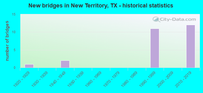
- New bridges - historical statistics
- 11920-1929
- 21940-1949
- 111990-1999
- 122010-2019

- Reconstructed bridges - Historical Statistics
- 11950-1959
- 01960-1969
- 01970-1979
- 01980-1989
- 11990-1999
- 02000-2009
- 12010-2019


- Bridge Condition - Deck
- 15.0%Very good
- 75.0%Good
- 10.0%Satisfactory

- Bridge Condition - Superstructure
- 50.0%Very good
- 45.0%Good
- 5.0%Satisfactory

- Bridge Condition - Substructure
- 25.0%Very good
- 65.0%Good
- 10.0%Satisfactory

- Bridge Condition - Channel
- 22.2%Very good
- 55.6%Good
- 22.2%Satisfactory
Find on map >> Show street view
Structure Number: 120800002708022, Location: 1.50 MI W OF SH 99 (Lat: 29.599344, Lng: -95.708575), Route carried "on" structure: Alternate US 90, Year Built: 1925, Year Reconstructed: 1956, Status: Open, Structure Length: 1.25m (4.10ft), Average Daily Traffic: 7,270 (year 2013), Truck Traffic: 4%, Average Future Daily Traffic: 10,180 (year 2033), Design Load: H 15, Features Intersected: DRAINAGE DITCH
Minimum Vertical Clearance: 30+ m (98+ ft), Kilometerpoint: 35.608, Lanes on structure: 2, Owner: State Highway Agency, Approaching Roadway Width: 11.6m (38.1ft), Material/Design: Concrete, Design/Construction: Slab, Number Of Spans In Main Unit: 2, Length of Maximum Span: 6.1m (20.0ft), Curb-To-Curb Width: 11.6m (38.1ft), Out-to-Out Width: 13.8m (45.3ft)
Condition: Deck: Good, Superstructure: Good, Substructure: Good, Channel: Good, Operating Rating: 42.6 metric tons, Method Used To Determine Operating Rating: Load Factor (LF), Inventory Rating: 25.4 metric tons, Method Used To Determine Inventory Rating: Load Factor (LF), Structural Evaluation: Equal to present minimum criteria, Deck Geometry: Equal to present minimum criteria, Waterway Adequacy: Equal to present minimum criteria, Approach Roadway Alignment: Equal to present desirable criteria, Length Of Structure Improvement: 1.25m (4.10ft), Designated Inspection Frequency: Every 24 months, Inspection Date: December 2020, Deck Structure Type: Concrete Cast-file-Place, Wearing Surface/Protective System: Wearing Surface: Bituminous
Find on map >> Show street view
Structure Number: 120800002708053, Location: 1.50 MI W OF SH 99 (Lat: 29.599117, Lng: -95.708533), Route carried "on" structure: Alternate US 90, Year Built: 1943, Year Reconstructed: 1997, Status: Open, Structure Length: 0.82m (2.69ft), Average Daily Traffic: 7,270 (year 2013), Truck Traffic: 4%, Average Future Daily Traffic: 10,180 (year 2033), Design Load: H 15, Features Intersected: Drainage Ditch
Minimum Vertical Clearance: 30+ m (98+ ft), Kilometerpoint: 35.608, Lanes on structure: 2, Owner: State Highway Agency, Approaching Roadway Width: 11.0m (36.1ft), Material/Design: Concrete, Design/Construction: Culvert, Number Of Spans In Main Unit: 4, Length of Maximum Span: 1.8m (5.9ft), Curb-To-Curb Width: 11.0m (36.1ft), Out-to-Out Width: 27.2m (89.2ft)
Condition: Channel: Good, Culverts: Good, Operating Rating: 39.9 metric tons, Method Used To Determine Operating Rating: Load Factor (LF), Inventory Rating: 23.6 metric tons, Method Used To Determine Inventory Rating: Load Factor (LF), Structural Evaluation: Somewhat better than minimum adequacy, Deck Geometry: Equal to present minimum criteria, Waterway Adequacy: Equal to present minimum criteria, Approach Roadway Alignment: Equal to present desirable criteria, Length Of Structure Improvement: 0.82m (2.69ft), Designated Inspection Frequency: Every 24 months, Inspection Date: October 2020, Deck Structure Type: Concrete Cast-file-Place, Wearing Surface/Protective System: Wearing Surface: Bituminous
Find on map >> Show street view
Structure Number: 120800002708057, Location: 0.95 MI W OF SH 6 (Lat: 29.606989, Lng: -95.663756), Route carried "on" structure: Alternate US 90, Year Built: 1942, Year Reconstructed: 2016, Status: Open, Structure Length: 3.05m (10.01ft), Average Daily Traffic: 27,544 (year 2019), Truck Traffic: 2%, Average Future Daily Traffic: 33,053 (year 2039), Design Load: H 20, Features Intersected: BULLHEAD BAYOU
Minimum Vertical Clearance: 30+ m (98+ ft), Kilometerpoint: 40.063, Lanes on structure: 3, Owner: State Highway Agency, Approaching Roadway Width: 14.6m (47.9ft), Material/Design: Concrete, Design/Construction: Slab, Number Of Spans In Main Unit: 5, Length of Maximum Span: 6.1m (20.0ft), Curb-To-Curb Width: 14.6m (47.9ft), Out-to-Out Width: 15.3m (50.2ft)
Condition: Deck: Good, Superstructure: Good, Substructure: Good, Channel: Very good, Operating Rating: 42.6 metric tons, Method Used To Determine Operating Rating: Load Factor (LF), Inventory Rating: 25.4 metric tons, Method Used To Determine Inventory Rating: Load Factor (LF), Structural Evaluation: Equal to present minimum criteria, Deck Geometry: Meets minimum limits, Waterway Adequacy: Equal to present minimum criteria, Approach Roadway Alignment: Equal to present desirable criteria, Length Of Structure Improvement: 3.05m (10.01ft), Designated Inspection Frequency: Every 24 months, Inspection Date: October 2020, Bridge Improvement Cost: $6,000, Roadway Improvement Cost: $2,000, Total Project Cost: $8,000, Deck Structure Type: Concrete Cast-file-Place, Wearing Surface/Protective System: Wearing Surface: Bituminous
Find on map >> Show street view
Structure Number: 120800002708534, Location: @ US 90A Intersection (Lat: 29.602897, Lng: -95.685328), Route carried "on" structure: Other road 99, Year Built: 2017, Status: Open, Structure Length: 70.79m (232.25ft), Average Daily Traffic: 44,973 (year 2019), Truck Traffic: 3%, Average Future Daily Traffic: 53,968 (year 2039), Design Load: HL 93, Features Intersected: US 90A
Minimum Vertical Clearance: 30+ m (98+ ft), Kilometerpoint: 0.000, Lanes on structure: 2, Lanes under structure: 20, Base Highway Network: Yes, Toll: On toll road, Owner: Local Toll Authority, Approaching Roadway Width: 12.2m (40.0ft), Skew: 19 degrees, Material/Design: Steel continuous, Design/Construction: Stringer/Multi-beam, Number Of Spans In Main Unit: 2, Number Of Approach Spans: 17, Length of Maximum Span: 67.4m (221.1ft), Curb-To-Curb Width: 12.2m (40.0ft), Out-to-Out Width: 12.9m (42.3ft)
Condition: Deck: Good, Superstructure: Very good, Substructure: Very good, Operating Rating: 54.4 metric tons, Method Used To Determine Operating Rating: Assigned ratings based on Load and Resistance Factor Design (LRFD) reported in metric tons, Inventory Rating: 32.7 metric tons, Method Used To Determine Inventory Rating: Assigned ratings based on Load and Resistance Factor Design (LRFD) reported in metric tons, Structural Evaluation: Equal to present desirable criteria, Deck Geometry: Better than present minimum criteria, Underclear: Meets minimum limits, Approach Roadway Alignment: Equal to present desirable criteria, Designated Inspection Frequency: Every 24 months, Inspection Date: December 2020, Deck Structure Type: Concrete Cast-file-Place
Find on map >> Show street view
Structure Number: 120800002708535, Location: @ US 90A Intersection (Lat: 29.600211, Lng: -95.683550), Route carried "on" structure: Other road 99, Year Built: 2017, Status: Open, Structure Length: 70.79m (232.25ft), Average Daily Traffic: 44,973 (year 2019), Truck Traffic: 3%, Average Future Daily Traffic: 53,968 (year 2039), Design Load: HL 93, Features Intersected: US 90A
Minimum Vertical Clearance: 30+ m (98+ ft), Kilometerpoint: 0.000, Lanes on structure: 2, Lanes under structure: 20, Base Highway Network: Yes, Toll: On toll road, Owner: Local Toll Authority, Approaching Roadway Width: 12.2m (40.0ft), Skew: 19 degrees, Material/Design: Steel continuous, Design/Construction: Stringer/Multi-beam, Number Of Spans In Main Unit: 2, Number Of Approach Spans: 17, Length of Maximum Span: 67.4m (221.1ft), Curb-To-Curb Width: 12.2m (40.0ft), Out-to-Out Width: 12.9m (42.3ft)
Condition: Deck: Good, Superstructure: Very good, Substructure: Very good, Operating Rating: 54.4 metric tons, Method Used To Determine Operating Rating: Assigned ratings based on Load and Resistance Factor Design (LRFD) reported in metric tons, Inventory Rating: 32.7 metric tons, Method Used To Determine Inventory Rating: Assigned ratings based on Load and Resistance Factor Design (LRFD) reported in metric tons, Structural Evaluation: Equal to present desirable criteria, Deck Geometry: Better than present minimum criteria, Underclear: Meets minimum limits, Approach Roadway Alignment: Equal to present desirable criteria, Designated Inspection Frequency: Every 24 months, Inspection Date: December 2020, Deck Structure Type: Concrete Cast-file-Place
Find on map >> Show street view
Structure Number: 120800141502196, Location: 0.20 MI N OF SH 99 (Lat: 29.606000, Lng: -95.683900), Route carried "on" structure: State highway 1464, Year Built: 2012, Status: Open, Structure Length: 3.05m (10.01ft), Average Daily Traffic: 6,684 (year 2020), Truck Traffic: 12%, Average Future Daily Traffic: 10,830 (year 2033), Design Load: HL 93, Features Intersected: Bullhead Slough
Minimum Vertical Clearance: 30+ m (98+ ft), Kilometerpoint: 28.038, Lanes on structure: 2, Owner: State Highway Agency, Approaching Roadway Width: 8.5m (27.9ft), Skew: 2 degrees, Material/Design: Prestressed concrete, Design/Construction: Stringer/Multi-beam, Number Of Spans In Main Unit: 1, Number Of Approach Spans: 2, Length of Maximum Span: 15.2m (49.9ft), Curb or Sidewalk Widths: Left: 0.0m, Right: 1.8m (5.9ft), Curb-To-Curb Width: 8.5m (27.9ft), Out-to-Out Width: 11.1m (36.4ft)
Condition: Deck: Very good, Superstructure: Very good, Substructure: Good, Channel: Very good, Operating Rating: 54.4 metric tons, Method Used To Determine Operating Rating: Assigned ratings based on Load and Resistance Factor Design (LRFD) reported in metric tons, Inventory Rating: 32.7 metric tons, Method Used To Determine Inventory Rating: Assigned ratings based on Load and Resistance Factor Design (LRFD) reported in metric tons, Structural Evaluation: Better than present minimum criteria, Deck Geometry: High priority of corrective action, Waterway Adequacy: Superior to present desirable criteria, Approach Roadway Alignment: Equal to present desirable criteria, Designated Inspection Frequency: Every 24 months, Inspection Date: September 2020, Deck Structure Type: Concrete Precast Panels
Find on map >> Show street view
Structure Number: 120800141502197, Location: 0.20 MI N OF SH 99 (Lat: 29.605900, Lng: -95.683600), Route carried "on" structure: State highway 1464, Year Built: 2012, Status: Open, Structure Length: 3.05m (10.01ft), Average Daily Traffic: 6,724 (year 2020), Truck Traffic: 12%, Average Future Daily Traffic: 10,830 (year 2033), Design Load: HL 93, Features Intersected: Bullhead Slough
Minimum Vertical Clearance: 30+ m (98+ ft), Kilometerpoint: 28.038, Lanes on structure: 2, Owner: State Highway Agency, Approaching Roadway Width: 8.5m (27.9ft), Skew: 2 degrees, Material/Design: Prestressed concrete, Design/Construction: Stringer/Multi-beam, Number Of Spans In Main Unit: 1, Number Of Approach Spans: 2, Length of Maximum Span: 15.2m (49.9ft), Curb or Sidewalk Widths: Left: 0.0m, Right: 1.8m (5.9ft), Curb-To-Curb Width: 8.5m (27.9ft), Out-to-Out Width: 11.1m (36.4ft)
Condition: Deck: Very good, Superstructure: Very good, Substructure: Very good, Channel: Very good, Operating Rating: 54.4 metric tons, Method Used To Determine Operating Rating: Assigned ratings based on Load and Resistance Factor Design (LRFD) reported in metric tons, Inventory Rating: 32.7 metric tons, Method Used To Determine Inventory Rating: Assigned ratings based on Load and Resistance Factor Design (LRFD) reported in metric tons, Structural Evaluation: Equal to present desirable criteria, Deck Geometry: High priority of corrective action, Waterway Adequacy: Superior to present desirable criteria, Approach Roadway Alignment: Equal to present desirable criteria, Designated Inspection Frequency: Every 24 months, Inspection Date: September 2020, Deck Structure Type: Concrete Precast Panels
Find on map >> Show street view
Structure Number: 120800351004018, Location: 1.95 MI N OF US 59 (Lat: 29.587175, Lng: -95.677831), Route carried "on" structure: Ramp State highway 99, Year Built: 1994, Status: Open, Structure Length: 4.27m (14.01ft), Average Daily Traffic: 9,459 (year 2019), Truck Traffic: 7%, Average Future Daily Traffic: 12,840 (year 2033), Design Load: HS 20, Features Intersected: Ditch 'M'
Minimum Vertical Clearance: 30+ m (98+ ft), Kilometerpoint: 2.918, Lanes on structure: 2, Owner: State Highway Agency, Approaching Roadway Width: 7.9m (25.9ft), Material/Design: Prestressed concrete, Design/Construction: Box Beam or Girders - Multiple, Number Of Spans In Main Unit: 3, Length of Maximum Span: 15.2m (49.9ft), Curb-To-Curb Width: 12.2m (40.0ft), Out-to-Out Width: 13.0m (42.7ft)
Condition: Deck: Good, Superstructure: Very good, Substructure: Good, Channel: Satisfactory, Operating Rating: 54.4 metric tons, Method Used To Determine Operating Rating: Assigned rating based on Load Factor Design (LFD) reported in metric tons, Inventory Rating: 32.7 metric tons, Method Used To Determine Inventory Rating: Assigned rating based on Load Factor Design (LFD) reported in metric tons, Structural Evaluation: Better than present minimum criteria, Deck Geometry: Superior to present desirable criteria, Waterway Adequacy: Superior to present desirable criteria, Approach Roadway Alignment: Equal to present desirable criteria, Designated Inspection Frequency: Every 24 months, Inspection Date: September 2020, Deck Structure Type: Concrete Precast Panels
Find on map >> Show street view
Structure Number: 120800351004019, Location: 1.95 MI N OF US 59 (Lat: 29.587258, Lng: -95.677136), Route carried "on" structure: Ramp State highway 99, Year Built: 1994, Status: Open, Structure Length: 4.27m (14.01ft), Average Daily Traffic: 9,433 (year 2019), Truck Traffic: 7%, Average Future Daily Traffic: 12,840 (year 2033), Design Load: HS 20, Features Intersected: Ditch 'M'
Minimum Vertical Clearance: 30+ m (98+ ft), Kilometerpoint: 2.939, Lanes on structure: 1, Owner: State Highway Agency, Approaching Roadway Width: 7.9m (25.9ft), Skew: 1 degrees, Material/Design: Prestressed concrete, Design/Construction: Box Beam or Girders - Multiple, Number Of Spans In Main Unit: 3, Length of Maximum Span: 15.2m (49.9ft), Curb-To-Curb Width: 12.2m (40.0ft), Out-to-Out Width: 13.0m (42.7ft)
Condition: Deck: Good, Superstructure: Good, Substructure: Good, Channel: Satisfactory, Operating Rating: 54.4 metric tons, Method Used To Determine Operating Rating: Assigned rating based on Load Factor Design (LFD) reported in metric tons, Inventory Rating: 32.7 metric tons, Method Used To Determine Inventory Rating: Assigned rating based on Load Factor Design (LFD) reported in metric tons, Structural Evaluation: Better than present minimum criteria, Deck Geometry: Superior to present desirable criteria, Waterway Adequacy: Superior to present desirable criteria, Approach Roadway Alignment: Somewhat better than minimum adequacy, Designated Inspection Frequency: Every 24 months, Inspection Date: September 2020, Deck Structure Type: Concrete Cast-file-Place, Wearing Surface/Protective System: Wearing Surface: Monolithic Concrete
Find on map >> Show street view
Structure Number: 120800351004021, Location: 0.40 MI N OF US 90A (Lat: 29.607033, Lng: -95.687244), Route carried "on" structure: ServiceState highway 99, Year Built: 1994, Status: Open, Structure Length: 4.42m (14.50ft), Average Daily Traffic: 22,786 (year 2017), Truck Traffic: 6%, Average Future Daily Traffic: 15,390 (year 2033), Design Load: HS 20, Features Intersected: Bullhead Slough
Minimum Vertical Clearance: 30+ m (98+ ft), Kilometerpoint: 5.303, Lanes on structure: 1, Owner: State Highway Agency, Approaching Roadway Width: 7.9m (25.9ft), Skew: 3 degrees, Material/Design: Prestressed concrete, Design/Construction: Stringer/Multi-beam, Number Of Spans In Main Unit: 3, Length of Maximum Span: 18.9m (62.0ft), Curb-To-Curb Width: 12.2m (40.0ft), Out-to-Out Width: 13.0m (42.7ft)
Condition: Deck: Satisfactory, Superstructure: Good, Substructure: Satisfactory, Channel: Satisfactory, Operating Rating: 54.4 metric tons, Method Used To Determine Operating Rating: Assigned rating based on Load Factor Design (LFD) reported in metric tons, Inventory Rating: 32.7 metric tons, Method Used To Determine Inventory Rating: Assigned rating based on Load Factor Design (LFD) reported in metric tons, Structural Evaluation: Equal to present minimum criteria, Deck Geometry: Somewhat better than minimum adequacy, Waterway Adequacy: Superior to present desirable criteria, Approach Roadway Alignment: Equal to present desirable criteria, Designated Inspection Frequency: Every 24 months, Inspection Date: September 2020, Deck Structure Type: Concrete Precast Panels, Wearing Surface/Protective System: Wearing Surface: Monolithic Concrete
Find on map >> Show street view
Structure Number: 120800351004022, Location: 0.4 MI N OF US 90A (Lat: 29.606883, Lng: -95.687528), Route carried "on" structure: ServiceState highway 99, Year Built: 1994, Status: Open, Structure Length: 4.15m (13.62ft), Average Daily Traffic: 22,187 (year 2017), Truck Traffic: 6%, Average Future Daily Traffic: 15,390 (year 2033), Design Load: HS 20, Features Intersected: Bullhead Slough
Minimum Vertical Clearance: 30+ m (98+ ft), Kilometerpoint: 5.330, Lanes on structure: 2, Owner: State Highway Agency, Approaching Roadway Width: 7.9m (25.9ft), Skew: 3 degrees, Material/Design: Prestressed concrete, Design/Construction: Stringer/Multi-beam, Number Of Spans In Main Unit: 3, Length of Maximum Span: 17.7m (58.1ft), Curb-To-Curb Width: 12.2m (40.0ft), Out-to-Out Width: 13.0m (42.7ft)
Condition: Deck: Satisfactory, Superstructure: Satisfactory, Substructure: Good, Channel: Satisfactory, Operating Rating: 54.4 metric tons, Method Used To Determine Operating Rating: Assigned rating based on Load Factor Design (LFD) reported in metric tons, Inventory Rating: 32.7 metric tons, Method Used To Determine Inventory Rating: Assigned rating based on Load Factor Design (LFD) reported in metric tons, Structural Evaluation: Equal to present minimum criteria, Deck Geometry: Better than present minimum criteria, Waterway Adequacy: Superior to present desirable criteria, Approach Roadway Alignment: Equal to present desirable criteria, Designated Inspection Frequency: Every 24 months, Inspection Date: September 2020, Deck Structure Type: Concrete Precast Panels, Wearing Surface/Protective System: Wearing Surface: Monolithic Concrete
Find on map >> Show street view
Structure Number: 120800351004023, Location: 4.50 MI N OF US 59 (Lat: 29.618011, Lng: -95.696308), Route carried "on" structure: State highway 99, Year Built: 1994, Status: Open, Structure Length: 1.04m (3.41ft), Average Daily Traffic: 44,973 (year 2019), Truck Traffic: 6%, Average Future Daily Traffic: 30,780 (year 2033), Design Load: HS 20, Features Intersected: Drainage Ditch
Minimum Vertical Clearance: 30+ m (98+ ft), Kilometerpoint: 6.857, Lanes on structure: 4, Owner: State Highway Agency, Approaching Roadway Width: 19.5m (64.0ft), Material/Design: Concrete, Design/Construction: Culvert, Number Of Spans In Main Unit: 4, Length of Maximum Span: 2.1m (6.9ft)
Condition: Channel: Very good, Culverts: Good, Operating Rating: 39.9 metric tons, Method Used To Determine Operating Rating: Load Factor (LF), Inventory Rating: 23.6 metric tons, Method Used To Determine Inventory Rating: Load Factor (LF), Structural Evaluation: Somewhat better than minimum adequacy, Waterway Adequacy: Equal to present minimum criteria, Approach Roadway Alignment: Equal to present desirable criteria, Designated Inspection Frequency: Every 48 months, Inspection Date: November 2020
Find on map >> Show street view
Structure Number: 120800351004103, Location: 2.0 MI NE of IH 69/US 59 (Lat: 29.586861, Lng: -95.677394), Route carried "on" structure: Other road 99, Year Built: 2017, Status: Open, Structure Length: 4.57m (14.99ft), Average Daily Traffic: 32,834 (year 2019), Truck Traffic: 5%, Average Future Daily Traffic: 39,401 (year 2039), Design Load: HL 93, Features Intersected: DITCH M
Minimum Vertical Clearance: 30+ m (98+ ft), Kilometerpoint: 0.000, Lanes on structure: 2, Base Highway Network: Yes, Toll: On toll road, Owner: Local Toll Authority, Approaching Roadway Width: 18.3m (60.0ft), Skew: 10 degrees, Material/Design: Prestressed concrete, Design/Construction: Stringer/Multi-beam, Number Of Spans In Main Unit: 3, Length of Maximum Span: 15.2m (49.9ft), Curb-To-Curb Width: 18.3m (60.0ft), Out-to-Out Width: 19.1m (62.7ft)
Condition: Deck: Very good, Superstructure: Very good, Substructure: Good, Channel: Good, Operating Rating: 54.4 metric tons, Method Used To Determine Operating Rating: Assigned ratings based on Load and Resistance Factor Design (LRFD) reported in metric tons, Inventory Rating: 32.7 metric tons, Method Used To Determine Inventory Rating: Assigned ratings based on Load and Resistance Factor Design (LRFD) reported in metric tons, Structural Evaluation: Better than present minimum criteria, Deck Geometry: Superior to present desirable criteria, Waterway Adequacy: Superior to present desirable criteria, Approach Roadway Alignment: Equal to present desirable criteria, Designated Inspection Frequency: Every 24 months, Inspection Date: December 2020, Deck Structure Type: Concrete Precast Panels
Find on map >> Show street view
Structure Number: 120800351004104, Location: 2.0 MI NE of IH 69/US 59 (Lat: 29.587631, Lng: -95.677714), Route carried "on" structure: Other road 99, Year Built: 2017, Status: Open, Structure Length: 4.57m (14.99ft), Average Daily Traffic: 32,834 (year 2019), Truck Traffic: 5%, Average Future Daily Traffic: 39,401 (year 2039), Design Load: HL 93, Features Intersected: DITCH M
Minimum Vertical Clearance: 30+ m (98+ ft), Kilometerpoint: 0.000, Lanes on structure: 2, Base Highway Network: Yes, Toll: On toll road, Owner: Local Toll Authority, Approaching Roadway Width: 18.6m (61.0ft), Skew: 10 degrees, Material/Design: Prestressed concrete, Design/Construction: Stringer/Multi-beam, Number Of Spans In Main Unit: 3, Length of Maximum Span: 15.2m (49.9ft), Curb-To-Curb Width: 18.7m (61.4ft), Out-to-Out Width: 19.4m (63.6ft)
Condition: Deck: Good, Superstructure: Very good, Substructure: Good, Channel: Good, Operating Rating: 54.4 metric tons, Method Used To Determine Operating Rating: Assigned ratings based on Load and Resistance Factor Design (LRFD) reported in metric tons, Inventory Rating: 32.7 metric tons, Method Used To Determine Inventory Rating: Assigned ratings based on Load and Resistance Factor Design (LRFD) reported in metric tons, Structural Evaluation: Better than present minimum criteria, Deck Geometry: Superior to present desirable criteria, Waterway Adequacy: Superior to present desirable criteria, Approach Roadway Alignment: Equal to present desirable criteria, Designated Inspection Frequency: Every 24 months, Inspection Date: December 2020, Deck Structure Type: Concrete Precast Panels
Find on map >> Show street view
Structure Number: 120800351004105, Location: 2.1 MI NE of IH 69/US 59 (Lat: 29.590339, Lng: -95.678817), Route carried "on" structure: Other road 99, Year Built: 2017, Status: Open, Structure Length: 9.21m (30.22ft), Average Daily Traffic: 32,834 (year 2019), Truck Traffic: 4%, Average Future Daily Traffic: 39,401 (year 2039), Design Load: HL 93, Features Intersected: NEW TERRITORY BLVD
Minimum Vertical Clearance: 30+ m (98+ ft), Kilometerpoint: 0.000, Lanes on structure: 2, Lanes under structure: 8, Base Highway Network: Yes, Toll: On toll road, Owner: Local Toll Authority, Approaching Roadway Width: 13.7m (44.9ft), Skew: 19 degrees, Material/Design: Prestressed concrete, Design/Construction: Stringer/Multi-beam, Number Of Spans In Main Unit: 1, Number Of Approach Spans: 2, Length of Maximum Span: 37.2m (122.0ft), Curb-To-Curb Width: 13.7m (44.9ft), Out-to-Out Width: 14.4m (47.2ft)
Condition: Deck: Good, Superstructure: Very good, Substructure: Very good, Operating Rating: 54.4 metric tons, Method Used To Determine Operating Rating: Assigned ratings based on Load and Resistance Factor Design (LRFD) reported in metric tons, Inventory Rating: 32.7 metric tons, Method Used To Determine Inventory Rating: Assigned ratings based on Load and Resistance Factor Design (LRFD) reported in metric tons, Structural Evaluation: Equal to present desirable criteria, Deck Geometry: Superior to present desirable criteria, Underclear: Meets minimum limits, Approach Roadway Alignment: Equal to present desirable criteria, Designated Inspection Frequency: Every 24 months, Inspection Date: December 2020, Deck Structure Type: Concrete Precast Panels
Find on map >> Show street view
Structure Number: 120800351004106, Location: 2.1 MI NE of IH 69/US 59 (Lat: 29.589350, Lng: -95.677908), Route carried "on" structure: Other road 99, Year Built: 2017, Status: Open, Structure Length: 9.21m (30.22ft), Average Daily Traffic: 32,834 (year 2019), Truck Traffic: 4%, Average Future Daily Traffic: 1 (year 1900), Design Load: HL 93, Features Intersected: NEW TERRITORY BLVD
Minimum Vertical Clearance: 30+ m (98+ ft), Kilometerpoint: 0.000, Lanes on structure: 2, Lanes under structure: 8, Base Highway Network: Yes, Toll: On toll road, Owner: Local Toll Authority, Approaching Roadway Width: 14.6m (47.9ft), Skew: 19 degrees, Material/Design: Prestressed concrete, Design/Construction: Stringer/Multi-beam, Number Of Spans In Main Unit: 1, Number Of Approach Spans: 2, Length of Maximum Span: 37.2m (122.0ft), Curb-To-Curb Width: 14.6m (47.9ft), Out-to-Out Width: 15.4m (50.5ft)
Condition: Deck: Good, Superstructure: Very good, Substructure: Very good, Operating Rating: 54.4 metric tons, Method Used To Determine Operating Rating: Assigned ratings based on Load and Resistance Factor Design (LRFD) reported in metric tons, Inventory Rating: 32.7 metric tons, Method Used To Determine Inventory Rating: Assigned ratings based on Load and Resistance Factor Design (LRFD) reported in metric tons, Structural Evaluation: Equal to present desirable criteria, Deck Geometry: Superior to present desirable criteria, Underclear: Meets minimum limits, Approach Roadway Alignment: Equal to present desirable criteria, Designated Inspection Frequency: Every 24 months, Inspection Date: December 2020, Deck Structure Type: Concrete Precast Panels
Find on map >> Show street view
Structure Number: 120800AA1171001, Location: 0.9 MI SW OF SH6 (Lat: 29.607178, Lng: -95.662061), Route carried "on" structure: County highway , Year Built: 1999, Status: Open, Structure Length: 3.17m (10.40ft), Average Daily Traffic: 100 (year 2013), Average Future Daily Traffic: 100 (year 2033), Features Intersected: BULLHEAD BAYOU, Facility Carried by Structure: CAMBRIDGE SCHOOL
Minimum Vertical Clearance: 30+ m (98+ ft), Kilometerpoint: 0.644, Lanes on structure: 2, Owner: County Highway Agency, Approaching Roadway Width: 7.3m (24.0ft), Skew: 1 degrees, Material/Design: Prestressed concrete, Design/Construction: Box Beam or Girders - Multiple, Number Of Spans In Main Unit: 2, Length of Maximum Span: 15.9m (52.2ft), Curb-To-Curb Width: 7.3m (24.0ft), Out-to-Out Width: 8.5m (27.9ft)
Condition: Deck: Good, Superstructure: Good, Substructure: Good, Channel: Good, Operating Rating: 32.7 metric tons, Method Used To Determine Operating Rating: Field evaluation and documented engineering judgment, Inventory Rating: 24.5 metric tons, Method Used To Determine Inventory Rating: Field evaluation and documented engineering judgment, Structural Evaluation: Equal to present minimum criteria, Deck Geometry: Equal to present minimum criteria, Waterway Adequacy: Better than present minimum criteria, Approach Roadway Alignment: Equal to present desirable criteria, Designated Inspection Frequency: Every 24 months, Inspection Date: October 2021, Deck Structure Type: Concrete Cast-file-Place
Find on map >> Show street view
Structure Number: 120800AA1173001, Location: 0.3 MI SW OF SH 99 (Lat: 29.587414, Lng: -95.681936), Route carried "on" structure: County highway , Year Built: 1999, Status: Open, Structure Length: 4.05m (13.29ft), Average Daily Traffic: 300 (year 2009), Average Future Daily Traffic: 2,000 (year 2029), Design Load: HS 20, Features Intersected: DRAINAGE DITCH, Facility Carried by Structure: NEW TERRITORY SB
Minimum Vertical Clearance: 30+ m (98+ ft), Kilometerpoint: 0.483, Lanes on structure: 2, Owner: County Highway Agency, Approaching Roadway Width: 7.3m (24.0ft), Material/Design: Prestressed concrete, Design/Construction: Box Beam or Girders - Multiple, Number Of Spans In Main Unit: 3, Length of Maximum Span: 14.3m (46.9ft), Curb or Sidewalk Widths: Left: 2.6m (8.5ft), Right: 0.0m, Curb-To-Curb Width: 7.3m (24.0ft), Out-to-Out Width: 11.4m (37.4ft)
Condition: Deck: Good, Superstructure: Good, Substructure: Satisfactory, Channel: Good, Operating Rating: 54.4 metric tons, Method Used To Determine Operating Rating: Assigned rating based on Load Factor Design (LFD) reported in metric tons, Inventory Rating: 32.7 metric tons, Method Used To Determine Inventory Rating: Assigned rating based on Load Factor Design (LFD) reported in metric tons, Structural Evaluation: Equal to present minimum criteria, Deck Geometry: High priority of replacement, Waterway Adequacy: Better than present minimum criteria, Approach Roadway Alignment: Equal to present desirable criteria, Designated Inspection Frequency: Every 24 months, Inspection Date: October 2021, Deck Structure Type: Concrete Cast-file-Place
Find on map >> Show street view
Structure Number: 120800AA1173002, Location: 0.3 MI SW OF SH 99 (Lat: 29.587011, Lng: -95.681961), Route carried "on" structure: County highway , Year Built: 1999, Status: Open, Structure Length: 4.05m (13.29ft), Average Daily Traffic: 300 (year 2009), Average Future Daily Traffic: 2,000 (year 2029), Design Load: HS 20, Features Intersected: DRAINAGE DITCH, Facility Carried by Structure: NEW TERRITORY NB
Minimum Vertical Clearance: 30+ m (98+ ft), Kilometerpoint: 0.483, Lanes on structure: 2, Owner: County Highway Agency, Approaching Roadway Width: 7.3m (24.0ft), Material/Design: Prestressed concrete, Design/Construction: Box Beam or Girders - Multiple, Number Of Spans In Main Unit: 3, Length of Maximum Span: 14.3m (46.9ft), Curb or Sidewalk Widths: Left: 0.0m, Right: 2.6m (8.5ft), Curb-To-Curb Width: 7.3m (24.0ft), Out-to-Out Width: 10.2m (33.5ft)
Condition: Deck: Good, Superstructure: Good, Substructure: Good, Channel: Good, Operating Rating: 54.4 metric tons, Method Used To Determine Operating Rating: Assigned rating based on Load Factor Design (LFD) reported in metric tons, Inventory Rating: 32.7 metric tons, Method Used To Determine Inventory Rating: Assigned rating based on Load Factor Design (LFD) reported in metric tons, Structural Evaluation: Better than present minimum criteria, Deck Geometry: High priority of replacement, Waterway Adequacy: Better than present minimum criteria, Approach Roadway Alignment: Equal to present desirable criteria, Designated Inspection Frequency: Every 24 months, Inspection Date: October 2021, Deck Structure Type: Concrete Cast-file-Place
Find on map >> Show street view
Structure Number: 120800AA1173003, Location: 0.5 MI E OF SH 99 (Lat: 29.591397, Lng: -95.670342), Route carried "on" structure: County highway , Year Built: 1996, Status: Open, Structure Length: 3.63m (11.91ft), Average Daily Traffic: 1,000 (year 2009), Average Future Daily Traffic: 2,000 (year 2028), Features Intersected: DRAINAGE DITCH, Facility Carried by Structure: NEW TERRITORY EB
Minimum Vertical Clearance: 30+ m (98+ ft), Kilometerpoint: 0.805, Lanes on structure: 2, Owner: County Highway Agency, Approaching Roadway Width: 7.3m (24.0ft), Skew: 1 degrees, Material/Design: Prestressed concrete, Design/Construction: Box Beam or Girders - Multiple, Number Of Spans In Main Unit: 3, Length of Maximum Span: 12.2m (40.0ft), Curb or Sidewalk Widths: Left: 1.4m (4.6ft), Right: 0.0m, Curb-To-Curb Width: 7.3m (24.0ft), Out-to-Out Width: 10.2m (33.5ft)
Condition: Deck: Good, Superstructure: Good, Substructure: Good, Channel: Good, Operating Rating: 32.7 metric tons, Method Used To Determine Operating Rating: Field evaluation and documented engineering judgment, Inventory Rating: 24.5 metric tons, Method Used To Determine Inventory Rating: Field evaluation and documented engineering judgment, Structural Evaluation: Equal to present minimum criteria, Deck Geometry: High priority of replacement, Waterway Adequacy: Superior to present desirable criteria, Approach Roadway Alignment: Equal to present desirable criteria, Length Of Structure Improvement: 3.63m (11.91ft), Designated Inspection Frequency: Every 24 months, Inspection Date: October 2021, Bridge Improvement Cost: $6,000, Roadway Improvement Cost: $2,000, Total Project Cost: $8,000, Deck Structure Type: Concrete Cast-file-Place
Find on map >> Show street view
Structure Number: 120800AA1173004, Location: 0.5 MI E OF SH 99 (Lat: 29.591547, Lng: -95.669892), Route carried "on" structure: County highway , Year Built: 1996, Status: Open, Structure Length: 3.63m (11.91ft), Average Daily Traffic: 1,000 (year 2009), Average Future Daily Traffic: 2,000 (year 2028), Features Intersected: DRAINAGE DITCH, Facility Carried by Structure: NEW TERRITORY WB
Minimum Vertical Clearance: 30+ m (98+ ft), Kilometerpoint: 0.805, Lanes on structure: 2, Owner: County Highway Agency, Approaching Roadway Width: 7.3m (24.0ft), Skew: 1 degrees, Material/Design: Prestressed concrete, Design/Construction: Box Beam or Girders - Multiple, Number Of Spans In Main Unit: 3, Length of Maximum Span: 12.2m (40.0ft), Curb or Sidewalk Widths: Left: 0.0m, Right: 2.5m (8.2ft), Curb-To-Curb Width: 7.3m (24.0ft), Out-to-Out Width: 11.5m (37.7ft)
Condition: Deck: Good, Superstructure: Very good, Substructure: Good, Channel: Good, Operating Rating: 32.7 metric tons, Method Used To Determine Operating Rating: Field evaluation and documented engineering judgment, Inventory Rating: 24.5 metric tons, Method Used To Determine Inventory Rating: Field evaluation and documented engineering judgment, Structural Evaluation: Equal to present minimum criteria, Deck Geometry: High priority of replacement, Waterway Adequacy: Superior to present desirable criteria, Approach Roadway Alignment: Equal to present desirable criteria, Length Of Structure Improvement: 3.63m (11.91ft), Designated Inspection Frequency: Every 24 months, Inspection Date: October 2021, Bridge Improvement Cost: $6,000, Roadway Improvement Cost: $2,000, Total Project Cost: $8,000, Deck Structure Type: Concrete Cast-file-Place
Find on map >> Show street view
Structure Number: 120800AA1174001, Location: 0.2 MI S NEW TERRITORY BL (Lat: 29.589089, Lng: -95.673697), Route carried "on" structure: County highway , Year Built: 1999, Status: Open, Structure Length: 3.75m (12.30ft), Average Daily Traffic: 500 (year 2009), Average Future Daily Traffic: 2,500 (year 2029), Features Intersected: DRAINAGE DITCH, Facility Carried by Structure: HOMEWARD WAY
Minimum Vertical Clearance: 30+ m (98+ ft), Kilometerpoint: 0.322, Lanes on structure: 2, Owner: County Highway Agency, Approaching Roadway Width: 11.3m (37.1ft), Skew: 1 degrees, Material/Design: Prestressed concrete, Design/Construction: Box Beam or Girders - Multiple, Number Of Spans In Main Unit: 3, Length of Maximum Span: 12.5m (41.0ft), Curb or Sidewalk Widths: Left: 1.4m (4.6ft), Right: 2.5m (8.2ft), Curb-To-Curb Width: 10.9m (35.8ft), Out-to-Out Width: 16.3m (53.5ft)
Condition: Deck: Good, Superstructure: Good, Substructure: Good, Channel: Good, Operating Rating: 32.7 metric tons, Method Used To Determine Operating Rating: Field evaluation and documented engineering judgment, Inventory Rating: 24.5 metric tons, Method Used To Determine Inventory Rating: Field evaluation and documented engineering judgment, Structural Evaluation: Equal to present minimum criteria, Deck Geometry: Equal to present minimum criteria, Waterway Adequacy: Better than present minimum criteria, Approach Roadway Alignment: Equal to present desirable criteria, Designated Inspection Frequency: Every 24 months, Inspection Date: October 2021, Deck Structure Type: Concrete Cast-file-Place
Find on map >> Show street view
Structure Number: 120800002708534, Location: @ US 90A Intersection (Lat: 29.602897, Lng: -95.685328), Route carried "under" structure: Alternate US 90, Year Built: 2017, Structure Length: 0. m, Average Daily Traffic: 28,939 (year 2019), Truck Traffic: 3%, Features Intersected: US 90A, Facility Carried by Structure: SH 99 SB
Minimum Vertical Clearance: 7.10m (23.29ft), Kilometerpoint: 0.000, Lanes on structure: 2, Lanes under structure: 20, Material/Design: Steel continuous, Design/Construction: Stringer/Multi-beam, Length of Maximum Span: 67.4m (221.1ft)
Find on map >> Show street view
Structure Number: 120800002708535, Location: @ US 90A Intersection (Lat: 29.600211, Lng: -95.683550), Route carried "under" structure: Alternate US 90, Year Built: 2017, Structure Length: 0. m, Average Daily Traffic: 28,939 (year 2019), Truck Traffic: 3%, Features Intersected: US 90A, Facility Carried by Structure: SH 99 NB
Minimum Vertical Clearance: 7.10m (23.29ft), Kilometerpoint: 0.000, Lanes on structure: 2, Lanes under structure: 20, Material/Design: Steel continuous, Design/Construction: Stringer/Multi-beam, Length of Maximum Span: 67.4m (221.1ft)
Find on map >> Show street view
Structure Number: 120800351004105, Location: 2.1 MI NE of IH 69/US 59 (Lat: 29.590339, Lng: -95.678817), Route carried "under" structure: City street , Year Built: 2017, Structure Length: 0. m, Average Daily Traffic: 8,745 (year 2019), Truck Traffic: 3%, Features Intersected: NEW TERRITORY BLVD, Facility Carried by Structure: SH 99 SB
Minimum Vertical Clearance: 5.18m (16.99ft), Kilometerpoint: 0.000, Lanes on structure: 2, Lanes under structure: 8, Material/Design: Prestressed concrete, Design/Construction: Stringer/Multi-beam, Length of Maximum Span: 37.2m (122.0ft)
Find on map >> Show street view
Structure Number: 120800351004106, Location: 2.1 MI NE of IH 69/US 59 (Lat: 29.589350, Lng: -95.677908), Route carried "under" structure: City street , Year Built: 2017, Structure Length: 0. m, Average Daily Traffic: 8,745 (year 2019), Truck Traffic: 3%, Features Intersected: NEW TERRITORY BLVD, Facility Carried by Structure: SH 99 NB
Minimum Vertical Clearance: 5.30m (17.39ft), Kilometerpoint: 0.000, Lanes on structure: 2, Lanes under structure: 8, Material/Design: Prestressed concrete, Design/Construction: Stringer/Multi-beam, Length of Maximum Span: 37.2m (122.0ft)