Bridge Statistics for Nickelsville, Virginia (VA)
Condition, Traffic, Stress, Structural Evaluation, Project Costs
- National Bridge Inventory (NBI) Statistics
- 19Number of bridges
- 125ft / 37.8mTotal length
- $1,683,000Total costs
- 8,330Total average daily traffic
- 265Total average daily truck traffic
- 10,342Total future (year 2040) average daily traffic
- National Bridge Inventory (NBI) Registered Bridges for Nickelsville
- No street view available for this location
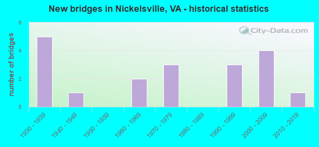
- New bridges - historical statistics
- 51930-1939
- 11940-1949
- 21960-1969
- 31970-1979
- 31990-1999
- 42000-2009
- 12010-2019

- Reconstructed bridges - Historical Statistics
- 11980-1989
- 11990-1999
- 42000-2009
- 12010-2019
- 12020-2022

- Bridge Condition - Deck
- 15.8%Very good
- 52.6%Good
- 21.1%Satisfactory
- 10.5%Fair

- Bridge Condition - Superstructure
- 26.3%Very good
- 36.8%Good
- 26.3%Satisfactory
- 10.5%Fair

- Bridge Condition - Substructure
- 26.3%Good
- 57.9%Satisfactory
- 15.8%Fair

- Bridge Condition - Channel
- 21.1%Very good
- 47.4%Satisfactory
- 31.6%Fair
Find on map >> Show street view
Structure Number: 16604, Location: 1.28 FR 688 - 0.68 TO 670 (Lat: 36.734669, Lng: -82.435231), Route carried "on" structure: State highway 71, Year Built: 1940, Year Reconstructed: 2013, Status: Open, Structure Length: 6.40m (21.00ft), Average Daily Traffic: 2,333 (year 2020), Truck Traffic: 4%, Average Future Daily Traffic: 2,566 (year 2040), Design Load: HS 20+Mod, Features Intersected: COPPER CREEK, Facility Carried by Structure: NICKELSVILLE HWY
Minimum Vertical Clearance: 30+ m (98+ ft), Kilometerpoint: 18.347, Lanes on structure: 2, Owner: State Highway Agency, Approaching Roadway Width: 7.3m (24.0ft), Material/Design: Steel, Design/Construction: Stringer/Multi-beam, Number Of Spans In Main Unit: 3, Length of Maximum Span: 20.7m (67.9ft), Curb-To-Curb Width: 7.3m (24.0ft), Out-to-Out Width: 12.8m (42.0ft)
Condition: Deck: Satisfactory, Superstructure: Very good, Substructure: Satisfactory, Channel: Very good, Operating Rating: 72.6 metric tons, Method Used To Determine Operating Rating: Load and Resistance Factor (LRFR), Inventory Rating: 55.3 metric tons, Method Used To Determine Inventory Rating: Load and Resistance Factor (LRFR), Structural Evaluation: Equal to present minimum criteria, Deck Geometry: High priority of replacement, Waterway Adequacy: Better than present minimum criteria, Approach Roadway Alignment: Equal to present minimum criteria, Length Of Structure Improvement: 7.59m (24.90ft), Designated Inspection Frequency: Every 24 months, Inspection Date: September 2021, Bridge Improvement Cost: $505,000, Roadway Improvement Cost: $50,000, Total Project Cost: $722,000, Deck Structure Type: Concrete Cast-file-Place, Wearing Surface/Protective System: Deck Protection: Other Coated Reinforcing
Find on map >> Show street view
Structure Number: 16607, Location: 0.5 TO 774;1.94 TO NICKEL (Lat: 36.767083, Lng: -82.384600), Route carried "on" structure: State highway 71, Year Built: 1932, Status: Open, Structure Length: 0.70m (2.30ft), Average Daily Traffic: 2,590 (year 2020), Truck Traffic: 4%, Average Future Daily Traffic: 3,626 (year 2040), Design Load: HS 20+Mod, Features Intersected: BIG SPRING BRANCH, Facility Carried by Structure: NICKLESVILLE HWY
Minimum Vertical Clearance: 30+ m (98+ ft), Kilometerpoint: 24.933, Lanes on structure: 2, Base Highway Network: Yes, Owner: State Highway Agency, Approaching Roadway Width: 8.8m (28.9ft), Skew: 4 degrees, Material/Design: Concrete, Design/Construction: Slab, Number Of Spans In Main Unit: 1, Length of Maximum Span: 6.1m (20.0ft), Curb-To-Curb Width: 7.3m (24.0ft), Out-to-Out Width: 7.9m (25.9ft)
Condition: Deck: Fair, Superstructure: Fair, Substructure: Satisfactory, Channel: Fair, Operating Rating: 45.4 metric tons, Method Used To Determine Operating Rating: Load and Resistance Factor (LRFR), Inventory Rating: 34.5 metric tons, Method Used To Determine Inventory Rating: Load and Resistance Factor (LRFR), Structural Evaluation: Somewhat better than minimum adequacy, Deck Geometry: High priority of replacement, Waterway Adequacy: Better than present minimum criteria, Approach Roadway Alignment: Better than present minimum criteria, Length Of Structure Improvement: 0.70m (2.30ft), Designated Inspection Frequency: Every 24 months, Inspection Date: January 2022, Bridge Improvement Cost: $25,000, Roadway Improvement Cost: $5,000, Total Project Cost: $39,000, Deck Structure Type: Concrete Cast-file-Place, Wearing Surface/Protective System: Wearing Surface: Bituminous
Find on map >> Show street view
Structure Number: 16636, Location: 3.10 TO R.C.L- 0.0 TO 611 (Lat: 36.753069, Lng: -82.379042), Route carried "on" structure: County highway 612, Year Built: 1932, Year Reconstructed: 1994, Status: Posted for load, Structure Length: 2.35m (7.71ft), Average Daily Traffic: 176 (year 2020), Average Future Daily Traffic: 246 (year 2040), Design Load: HS 20, Features Intersected: COPPER CREEK, Facility Carried by Structure: LITTLE DUCK RD
Minimum Vertical Clearance: 30+ m (98+ ft), Kilometerpoint: 4.763, Lanes on structure: 2, Owner: State Highway Agency, Approaching Roadway Width: 5.5m (18.0ft), Material/Design: Steel, Design/Construction: Stringer/Multi-beam, Number Of Spans In Main Unit: 2, Length of Maximum Span: 11.6m (38.1ft), Curb-To-Curb Width: 7.3m (24.0ft), Out-to-Out Width: 7.9m (25.9ft)
Condition: Deck: Good, Superstructure: Satisfactory, Substructure: Fair, Channel: Satisfactory, Operating Rating: 39.9 metric tons, Method Used To Determine Operating Rating: Load and Resistance Factor (LRFR), Inventory Rating: 30.8 metric tons, Method Used To Determine Inventory Rating: Load and Resistance Factor (LRFR), Structural Evaluation: Somewhat better than minimum adequacy, Waterway Adequacy: Better than present minimum criteria, Approach Roadway Alignment: Better than present minimum criteria, Bridge Posting: Required (Relationship of Operating Rating to Maximum Legal Load: 20.0 - 29.9% below), Designated Inspection Frequency: Every 24 months, Inspection Date: October 2020, Deck Structure Type: Wood or Timber, Wearing Surface/Protective System: Wearing Surface: Bituminous
Find on map >> Show street view
Structure Number: 1681, Location: 1.8M TO 71 & .60M TO 673 (Lat: 36.736200, Lng: -82.447406), Route carried "on" structure: County highway 670, Year Built: 1932, Status: Posted for load, Structure Length: 0.85m (2.79ft), Average Daily Traffic: 198 (year 2016), Average Future Daily Traffic: 297 (year 2042), Design Load: HS 20, Features Intersected: COPPER CREEK, Facility Carried by Structure: Wayside Meadows Rd
Minimum Vertical Clearance: 30+ m (98+ ft), Kilometerpoint: 10.619, Lanes on structure: 1, Owner: State Highway Agency, Approaching Roadway Width: 4.3m (14.1ft), Material/Design: Steel, Design/Construction: Stringer/Multi-beam, Number Of Spans In Main Unit: 1, Length of Maximum Span: 8.5m (27.9ft), Curb-To-Curb Width: 3.4m (11.2ft), Out-to-Out Width: 3.4m (11.2ft)
Condition: Deck: Fair, Superstructure: Fair, Substructure: Fair, Channel: Satisfactory, Operating Rating: 20.9 metric tons, Method Used To Determine Operating Rating: Load Factor (LF), Inventory Rating: 11.8 metric tons, Method Used To Determine Inventory Rating: Load Factor (LF), Structural Evaluation: Meets minimum limits, Deck Geometry: High priority of replacement, Waterway Adequacy: High priority of replacement, Approach Roadway Alignment: High priority of replacement, Bridge Posting: Required (Relationship of Operating Rating to Maximum Legal Load: > 39.9% below), Length Of Structure Improvement: 0.85m (2.79ft), Designated Inspection Frequency: Every 24 months, Inspection Date: March 2022, Bridge Improvement Cost: $59,000, Roadway Improvement Cost: $20,000, Total Project Cost: $103,000 ( Estimate for 2015), Deck Structure Type: Wood or Timber
Find on map >> Show street view
Structure Number: 16817, Location: 0.6 fr 678;0.0 to 678S (Lat: 36.747161, Lng: -82.475519), Route carried "on" structure: County highway 671, Year Built: 1973, Year Reconstructed: 2008, Status: Open, Structure Length: 1.01m (3.31ft), Average Daily Traffic: 191 (year 2020), Truck Traffic: 4%, Average Future Daily Traffic: 212 (year 2040), Design Load: HS 20, Features Intersected: BRANCH, Facility Carried by Structure: VALLEY CREEK RD
Minimum Vertical Clearance: 30+ m (98+ ft), Kilometerpoint: 13.548, Lanes on structure: 2, Owner: State Highway Agency, Approaching Roadway Width: 5.2m (17.1ft), Skew: 1 degrees, Material/Design: Steel, Design/Construction: Stringer/Multi-beam, Number Of Spans In Main Unit: 1, Length of Maximum Span: 9.4m (30.8ft), Curb-To-Curb Width: 7.0m (23.0ft), Out-to-Out Width: 7.3m (24.0ft)
Condition: Deck: Very good, Superstructure: Good, Substructure: Satisfactory, Channel: Satisfactory, Operating Rating: 52.6 metric tons, Method Used To Determine Operating Rating: Load and Resistance Factor (LRFR), Inventory Rating: 39.9 metric tons, Method Used To Determine Inventory Rating: Load and Resistance Factor (LRFR), Structural Evaluation: Equal to present minimum criteria, Deck Geometry: Meets minimum limits, Waterway Adequacy: Better than present minimum criteria, Approach Roadway Alignment: Better than present minimum criteria, Designated Inspection Frequency: Every 24 months, Inspection Date: June 2020, Deck Structure Type: Wood or Timber, Wearing Surface/Protective System: Wearing Surface: Bituminous
Find on map >> Show street view
Structure Number: 16818, Location: 0.30 FR 679 - 0.80 TO 678 (Lat: 36.745211, Lng: -82.478306), Route carried "on" structure: County highway 671, Year Built: 1973, Year Reconstructed: 2008, Status: Open, Structure Length: 1.16m (3.81ft), Average Daily Traffic: 191 (year 2020), Truck Traffic: 4%, Average Future Daily Traffic: 212 (year 2040), Design Load: HS 20, Features Intersected: VALLEY CREEK, Facility Carried by Structure: VALLEY CREEK RD
Minimum Vertical Clearance: 30+ m (98+ ft), Kilometerpoint: 12.100, Lanes on structure: 2, Owner: State Highway Agency, Approaching Roadway Width: 6.1m (20.0ft), Material/Design: Steel, Design/Construction: Stringer/Multi-beam, Number Of Spans In Main Unit: 1, Length of Maximum Span: 11.0m (36.1ft), Curb-To-Curb Width: 6.9m (22.6ft), Out-to-Out Width: 7.1m (23.3ft)
Condition: Deck: Good, Superstructure: Good, Substructure: Satisfactory, Channel: Satisfactory, Operating Rating: 52.6 metric tons, Method Used To Determine Operating Rating: Load and Resistance Factor (LRFR), Inventory Rating: 40.8 metric tons, Method Used To Determine Inventory Rating: Load and Resistance Factor (LRFR), Structural Evaluation: Equal to present minimum criteria, Deck Geometry: Meets minimum limits, Waterway Adequacy: Better than present minimum criteria, Approach Roadway Alignment: Better than present minimum criteria, Length Of Structure Improvement: 1.16m (3.81ft), Designated Inspection Frequency: Every 24 months, Inspection Date: June 2020, Deck Structure Type: Wood or Timber, Wearing Surface/Protective System: Wearing Surface: Bituminous
Find on map >> Show street view
Structure Number: 16827, Location: 1.05M TO673 & .0M TO 671 (Lat: 36.750975, Lng: -82.466614), Route carried "on" structure: County highway 678, Year Built: 1932, Year Reconstructed: 2016, Status: Open, Structure Length: 1.01m (3.31ft), Average Daily Traffic: 46 (year 2016), Average Future Daily Traffic: 52 (year 2040), Design Load: HS 20, Features Intersected: VALLEY CREEK, Facility Carried by Structure: MARVIN SPRINGS RD
Minimum Vertical Clearance: 30+ m (98+ ft), Kilometerpoint: 2.806, Lanes on structure: 1, Owner: State Highway Agency, Approaching Roadway Width: 4.6m (15.1ft), Skew: 1 degrees, Material/Design: Concrete, Design/Construction: Slab, Number Of Spans In Main Unit: 1, Length of Maximum Span: 9.1m (29.9ft), Curb-To-Curb Width: 4.6m (15.1ft), Out-to-Out Width: 4.9m (16.1ft)
Condition: Deck: Very good, Superstructure: Very good, Substructure: Satisfactory, Channel: Fair, Operating Rating: 65.3 metric tons, Method Used To Determine Operating Rating: Load and Resistance Factor (LRFR), Inventory Rating: 49.9 metric tons, Method Used To Determine Inventory Rating: Load and Resistance Factor (LRFR), Structural Evaluation: Equal to present minimum criteria, Deck Geometry: Better than present minimum criteria, Waterway Adequacy: Meets minimum limits, Approach Roadway Alignment: Better than present minimum criteria, Length Of Structure Improvement: 1.01m (3.31ft), Designated Inspection Frequency: Every 24 months, Inspection Date: May 2020, Bridge Improvement Cost: $69,000, Roadway Improvement Cost: $10,000, Total Project Cost: $103,000 ( Estimate for 2015), Deck Structure Type: Concrete Precast Panels, Wearing Surface/Protective System: Wearing Surface: Bituminous
Find on map >> Show street view
Structure Number: 16828, Location: .05M TO 681 & .50M TO 678 (Lat: 36.755708, Lng: -82.435003), Route carried "on" structure: County highway 680, Year Built: 1961, Year Reconstructed: 2009, Status: Open, Structure Length: 0.72m (2.36ft), Average Daily Traffic: 495 (year 2020), Truck Traffic: 5%, Average Future Daily Traffic: 598 (year 2040), Design Load: HS 20+Mod, Features Intersected: Crackers Neck Branch, Facility Carried by Structure: Twin Springs Rd
Minimum Vertical Clearance: 30+ m (98+ ft), Kilometerpoint: 19.752, Lanes on structure: 2, Owner: State Highway Agency, Approaching Roadway Width: 5.8m (19.0ft), Material/Design: Concrete, Design/Construction: Slab, Number Of Spans In Main Unit: 1, Length of Maximum Span: 6.4m (21.0ft), Curb-To-Curb Width: 6.4m (21.0ft), Out-to-Out Width: 6.6m (21.7ft)
Condition: Deck: Good, Superstructure: Good, Substructure: Satisfactory, Channel: Fair, Operating Rating: 56.2 metric tons, Method Used To Determine Operating Rating: Load and Resistance Factor (LRFR), Inventory Rating: 43.5 metric tons, Method Used To Determine Inventory Rating: Load and Resistance Factor (LRFR), Structural Evaluation: Equal to present minimum criteria, Deck Geometry: High priority of corrective action, Waterway Adequacy: Better than present minimum criteria, Approach Roadway Alignment: Better than present minimum criteria, Length Of Structure Improvement: 0.76m (2.49ft), Designated Inspection Frequency: Every 24 months, Inspection Date: August 2021, Bridge Improvement Cost: $102,000, Roadway Improvement Cost: $25,000, Total Project Cost: $165,000 ( Estimate for 2015), Deck Structure Type: Concrete Precast Panels, Wearing Surface/Protective System: Wearing Surface: Bituminous, Deck Protection: Other Coated Reinforcing
Find on map >> Show street view
Structure Number: 16831, Location: 0000671 0080677 (Lat: 36.774844, Lng: -82.464708), Route carried "on" structure: County highway 680, Year Built: 1973, Status: Posted for load, Structure Length: 0.76m (2.49ft), Average Daily Traffic: 157 (year 2016), Average Future Daily Traffic: 221 (year 2040), Design Load: HS 20, Features Intersected: BRANCH, Facility Carried by Structure: LURAY RD
Minimum Vertical Clearance: 30+ m (98+ ft), Kilometerpoint: 16.373, Lanes on structure: 2, Owner: State Highway Agency, Approaching Roadway Width: 5.5m (18.0ft), Material/Design: Steel, Design/Construction: Stringer/Multi-beam, Number Of Spans In Main Unit: 1, Length of Maximum Span: 6.7m (22.0ft), Curb-To-Curb Width: 7.3m (24.0ft), Out-to-Out Width: 7.6m (24.9ft)
Condition: Deck: Good, Superstructure: Very good, Substructure: Satisfactory, Channel: Satisfactory, Operating Rating: 45.4 metric tons, Method Used To Determine Operating Rating: Load and Resistance Factor (LRFR), Inventory Rating: 35.4 metric tons, Method Used To Determine Inventory Rating: Load and Resistance Factor (LRFR), Structural Evaluation: Equal to present minimum criteria, Deck Geometry: Somewhat better than minimum adequacy, Waterway Adequacy: Better than present minimum criteria, Approach Roadway Alignment: Better than present minimum criteria, Length Of Structure Improvement: 0.76m (2.49ft), Designated Inspection Frequency: Every 24 months, Inspection Date: October 2020, Bridge Improvement Cost: $121,000, Roadway Improvement Cost: $25,000, Total Project Cost: $190,000, Deck Structure Type: Wood or Timber, Wearing Surface/Protective System: Wearing Surface: Bituminous
Find on map >> Show street view
Structure Number: 16832, Location: 0.3 FR 680; 0.6 TO 682 (Lat: 36.759703, Lng: -82.433194), Route carried "on" structure: County highway 681, Year Built: 1932, Year Reconstructed: 1990, Status: Posted for load, Structure Length: 0.82m (2.69ft), Average Daily Traffic: 142 (year 2016), Average Future Daily Traffic: 185 (year 2040), Features Intersected: CRACKERS NECK BRANCH, Facility Carried by Structure: BUSH MILL RD
Minimum Vertical Clearance: 30+ m (98+ ft), Kilometerpoint: 0.483, Lanes on structure: 1, Owner: State Highway Agency, Approaching Roadway Width: 5.5m (18.0ft), Skew: 3 degrees, Material/Design: Steel, Design/Construction: Stringer/Multi-beam, Number Of Spans In Main Unit: 1, Length of Maximum Span: 7.0m (23.0ft), Curb or Sidewalk Widths: Left: 0.2m (0.7ft), Right: 0.2m (0.7ft), Curb-To-Curb Width: 4.4m (14.4ft), Out-to-Out Width: 4.8m (15.7ft)
Condition: Deck: Good, Superstructure: Satisfactory, Substructure: Fair, Channel: Satisfactory, Operating Rating: 40.8 metric tons, Method Used To Determine Operating Rating: Load Factor (LF), Inventory Rating: 24.5 metric tons, Method Used To Determine Inventory Rating: Load Factor (LF), Structural Evaluation: Somewhat better than minimum adequacy, Deck Geometry: High priority of replacement, Waterway Adequacy: Better than present minimum criteria, Approach Roadway Alignment: Better than present minimum criteria, Length Of Structure Improvement: 0.82m (2.69ft), Designated Inspection Frequency: Every 24 months, Inspection Date: May 2020, Bridge Improvement Cost: $57,000, Roadway Improvement Cost: $20,000, Total Project Cost: $101,000, Deck Structure Type: Wood or Timber, Wearing Surface/Protective System: Wearing Surface: Bituminous
Find on map >> Show street view
Structure Number: 1684, Location: 2.70 FR 613-1.60 TO 71 (Lat: 36.740731, Lng: -82.400467), Route carried "on" structure: County highway 682, Year Built: 1963, Year Reconstructed: 2020, Status: Open, Structure Length: 3.17m (10.40ft), Average Daily Traffic: 140 (year 2016), Average Future Daily Traffic: 157 (year 2040), Design Load: HL 93, Features Intersected: COPPER CREEK, Facility Carried by Structure: DEAN HOLLOW RD
Minimum Vertical Clearance: 30+ m (98+ ft), Kilometerpoint: 4.344, Lanes on structure: 1, Owner: State Highway Agency, Approaching Roadway Width: 5.5m (18.0ft), Material/Design: Steel, Design/Construction: Stringer/Multi-beam, Number Of Spans In Main Unit: 1, Length of Maximum Span: 30.2m (99.1ft), Curb-To-Curb Width: 5.5m (18.0ft), Out-to-Out Width: 5.8m (19.0ft)
Condition: Deck: Very good, Superstructure: Very good, Substructure: Good, Channel: Very good, Operating Rating: 60.8 metric tons, Method Used To Determine Operating Rating: Load and Resistance Factor (LRFR), Inventory Rating: 46.3 metric tons, Method Used To Determine Inventory Rating: Load and Resistance Factor (LRFR), Structural Evaluation: Better than present minimum criteria, Deck Geometry: High priority of corrective action, Waterway Adequacy: Better than present minimum criteria, Approach Roadway Alignment: Meets minimum limits, Length Of Structure Improvement: 3.17m (10.40ft), Designated Inspection Frequency: Every 24 months, Inspection Date: April 2020, Bridge Improvement Cost: $190,000, Roadway Improvement Cost: $10,000, Total Project Cost: $260,000 ( Estimate for 2018), Deck Structure Type: Corrugated Steel, Wearing Surface/Protective System: Wearing Surface: Monolithic Concrete
Find on map >> Show street view
Structure Number: 23557, Location: 1.35 FR 687 - 0.75 TO 688 (Lat: 36.701858, Lng: -82.430072), Route carried "on" structure: County highway 613, Year Built: 1992, Status: Open, Structure Length: 3.72m (12.20ft), Average Daily Traffic: 346 (year 2020), Truck Traffic: 2%, Average Future Daily Traffic: 381 (year 2040), Design Load: HS 20+Mod, Features Intersected: BIG MOCCASIN CREEK, Facility Carried by Structure: BIG MOCCASIN RD
Minimum Vertical Clearance: 30+ m (98+ ft), Kilometerpoint: 5.535, Lanes on structure: 2, Owner: State Highway Agency, Approaching Roadway Width: 6.7m (22.0ft), Material/Design: Steel, Design/Construction: Stringer/Multi-beam, Number Of Spans In Main Unit: 2, Length of Maximum Span: 18.3m (60.0ft), Curb-To-Curb Width: 7.9m (25.9ft), Out-to-Out Width: 9.1m (29.9ft)
Condition: Deck: Good, Superstructure: Good, Substructure: Good, Channel: Fair, Operating Rating: 89.8 metric tons, Method Used To Determine Operating Rating: Load and Resistance Factor (LRFR), Inventory Rating: 68.9 metric tons, Method Used To Determine Inventory Rating: Load and Resistance Factor (LRFR), Structural Evaluation: Better than present minimum criteria, Waterway Adequacy: Better than present minimum criteria, Approach Roadway Alignment: Better than present minimum criteria, Designated Inspection Frequency: Every 24 months, Inspection Date: Febuary 2021, Deck Structure Type: Concrete Cast-file-Place
Find on map >> Show street view
Structure Number: 2526, Location: .3MTO682&2.4MTORUSS.COLN. (Lat: 36.715053, Lng: -82.372617), Route carried "on" structure: County highway 613, Year Built: 1998, Status: Open, Structure Length: 1.95m (6.40ft), Average Daily Traffic: 118 (year 2020), Truck Traffic: 8%, Average Future Daily Traffic: 177 (year 2042), Design Load: HS 20+Mod, Features Intersected: BIG MOCCASIN CREEK, Facility Carried by Structure: Big Moccasin Rd
Minimum Vertical Clearance: 30+ m (98+ ft), Kilometerpoint: 11.231, Lanes on structure: 2, Owner: State Highway Agency, Approaching Roadway Width: 5.5m (18.0ft), Material/Design: Concrete, Design/Construction: Slab, Number Of Spans In Main Unit: 2, Length of Maximum Span: 9.8m (32.2ft), Curb-To-Curb Width: 7.3m (24.0ft), Out-to-Out Width: 7.9m (25.9ft)
Condition: Deck: Satisfactory, Superstructure: Satisfactory, Substructure: Satisfactory, Channel: Satisfactory, Operating Rating: 89.8 metric tons, Method Used To Determine Operating Rating: Load and Resistance Factor (LRFR), Inventory Rating: 86.2 metric tons, Method Used To Determine Inventory Rating: Load and Resistance Factor (LRFR), Structural Evaluation: Equal to present minimum criteria, Deck Geometry: Somewhat better than minimum adequacy, Waterway Adequacy: Better than present minimum criteria, Approach Roadway Alignment: Equal to present desirable criteria, Designated Inspection Frequency: Every 24 months, Inspection Date: March 2022, Deck Structure Type: Concrete Cast-file-Place, Wearing Surface/Protective System: Deck Protection: Epoxy Coated Reinforcing
Find on map >> Show street view
Structure Number: 25469, Location: 0.35 FR 613 & 3.95 TO 71 (Lat: 36.716317, Lng: -82.388531), Route carried "on" structure: County highway 682, Year Built: 1998, Status: Open, Structure Length: 2.32m (7.61ft), Average Daily Traffic: 97 (year 2016), Average Future Daily Traffic: 144 (year 2040), Design Load: HS 20+Mod, Features Intersected: BIG MOCCASIN CREEK, Facility Carried by Structure: DEAN HOLLOW RD
Minimum Vertical Clearance: 30+ m (98+ ft), Kilometerpoint: 0.563, Lanes on structure: 2, Owner: State Highway Agency, Approaching Roadway Width: 6.7m (22.0ft), Material/Design: Concrete, Design/Construction: Slab, Number Of Spans In Main Unit: 3, Length of Maximum Span: 8.2m (26.9ft), Curb-To-Curb Width: 6.7m (22.0ft), Out-to-Out Width: 7.3m (24.0ft)
Condition: Deck: Satisfactory, Superstructure: Satisfactory, Substructure: Satisfactory, Channel: Satisfactory, Operating Rating: 89.8 metric tons, Method Used To Determine Operating Rating: Load and Resistance Factor (LRFR), Inventory Rating: 76.2 metric tons, Method Used To Determine Inventory Rating: Load and Resistance Factor (LRFR), Structural Evaluation: Equal to present minimum criteria, Deck Geometry: Somewhat better than minimum adequacy, Waterway Adequacy: Better than present minimum criteria, Approach Roadway Alignment: Equal to present desirable criteria, Designated Inspection Frequency: Every 24 months, Inspection Date: May 2020, Deck Structure Type: Concrete Cast-file-Place, Wearing Surface/Protective System: Deck Protection: Epoxy Coated Reinforcing
Find on map >> Show street view
Structure Number: 2651, Location: 0.2 TO 682 & .66 TO 680 (Lat: 36.763206, Lng: -82.428983), Route carried "on" structure: County highway 681, Year Built: 2000, Status: Open, Structure Length: 0.98m (3.22ft), Average Daily Traffic: 142 (year 2016), Average Future Daily Traffic: 185 (year 2040), Design Load: HS 20+Mod, Features Intersected: Crackers Neck Branch, Facility Carried by Structure: Bush Mill Road
Minimum Vertical Clearance: 30+ m (98+ ft), Kilometerpoint: 0.322, Lanes on structure: 2, Owner: State Highway Agency, Approaching Roadway Width: 6.7m (22.0ft), Material/Design: Concrete, Design/Construction: Frame, Number Of Spans In Main Unit: 1, Length of Maximum Span: 9.1m (29.9ft), Curb-To-Curb Width: 6.7m (22.0ft), Out-to-Out Width: 7.2m (23.6ft)
Condition: Deck: Satisfactory, Superstructure: Satisfactory, Substructure: Good, Channel: Fair, Operating Rating: 43.5 metric tons, Method Used To Determine Operating Rating: Load and Resistance Factor (LRFR), Inventory Rating: 33.6 metric tons, Method Used To Determine Inventory Rating: Load and Resistance Factor (LRFR), Structural Evaluation: Equal to present minimum criteria, Deck Geometry: Meets minimum limits, Waterway Adequacy: Better than present minimum criteria, Approach Roadway Alignment: Better than present minimum criteria, Designated Inspection Frequency: Every 24 months, Inspection Date: October 2020, Deck Structure Type: Concrete Precast Panels, Wearing Surface/Protective System: Wearing Surface: Bituminous, Deck Protection: Epoxy Coated Reinforcing
Find on map >> Show street view
Structure Number: 27338, Location: 1.10 fr 891;0.0 to 688 (Lat: 36.707783, Lng: -82.419244), Route carried "on" structure: County highway 613, Year Built: 2002, Status: Open, Structure Length: 2.93m (9.61ft), Average Daily Traffic: 346 (year 2020), Truck Traffic: 2%, Average Future Daily Traffic: 381 (year 2040), Design Load: HS 20+Mod, Features Intersected: BIG MOCCASIN CREEK, Facility Carried by Structure: BIG MOCCASIN RD
Minimum Vertical Clearance: 30+ m (98+ ft), Kilometerpoint: 6.806, Lanes on structure: 2, Owner: State Highway Agency, Approaching Roadway Width: 7.6m (24.9ft), Skew: 3 degrees, Material/Design: Concrete, Design/Construction: Slab, Number Of Spans In Main Unit: 3, Length of Maximum Span: 9.8m (32.2ft), Curb-To-Curb Width: 7.6m (24.9ft), Out-to-Out Width: 8.2m (26.9ft)
Condition: Deck: Good, Superstructure: Good, Substructure: Satisfactory, Channel: Satisfactory, Operating Rating: 89.8 metric tons, Method Used To Determine Operating Rating: Load and Resistance Factor (LRFR), Inventory Rating: 88.9 metric tons, Method Used To Determine Inventory Rating: Load and Resistance Factor (LRFR), Structural Evaluation: Equal to present minimum criteria, Deck Geometry: Somewhat better than minimum adequacy, Waterway Adequacy: Better than present minimum criteria, Approach Roadway Alignment: Better than present minimum criteria, Designated Inspection Frequency: Every 24 months, Inspection Date: October 2020, Deck Structure Type: Concrete Cast-file-Place, Wearing Surface/Protective System: Deck Protection: Epoxy Coated Reinforcing
Find on map >> Show street view
Structure Number: 27881, Location: .01M RT 613 &.12M DEAD EN (Lat: 36.712472, Lng: -82.378611), Route carried "on" structure: County highway 852, Year Built: 2008, Status: Open, Structure Length: 1.95m (6.40ft), Average Daily Traffic: 45 (year 2016), Average Future Daily Traffic: 67 (year 2040), Design Load: HS 20+Mod, Features Intersected: BIG MOCCASIN CREEK, Facility Carried by Structure: LOW WATER LANE
Minimum Vertical Clearance: 30+ m (98+ ft), Kilometerpoint: 0.000, Lanes on structure: 2, Owner: State Highway Agency, Approaching Roadway Width: 7.3m (24.0ft), Skew: 1 degrees, Material/Design: Concrete, Design/Construction: Slab, Number Of Spans In Main Unit: 2, Length of Maximum Span: 9.8m (32.2ft), Curb-To-Curb Width: 7.0m (23.0ft), Out-to-Out Width: 7.9m (25.9ft)
Condition: Deck: Good, Superstructure: Good, Substructure: Satisfactory, Channel: Fair, Operating Rating: 76.2 metric tons, Method Used To Determine Operating Rating: Load and Resistance Factor (LRFR), Inventory Rating: 59.0 metric tons, Method Used To Determine Inventory Rating: Load and Resistance Factor (LRFR), Structural Evaluation: Equal to present minimum criteria, Deck Geometry: Somewhat better than minimum adequacy, Waterway Adequacy: Better than present minimum criteria, Approach Roadway Alignment: Better than present minimum criteria, Designated Inspection Frequency: Every 24 months, Inspection Date: April 2020, Deck Structure Type: Concrete Cast-file-Place, Wearing Surface/Protective System: Wearing Surface: Monolithic Concrete, Deck Protection: Epoxy Coated Reinforcing
Find on map >> Show street view
Structure Number: 292, Location: 0.45 TO 688 & 0.65 TO 891 (Lat: 36.707575, Lng: -82.411833), Route carried "on" structure: County highway 613, Year Built: 2009, Status: Open, Structure Length: 3.08m (10.10ft), Average Daily Traffic: 346 (year 2020), Truck Traffic: 2%, Average Future Daily Traffic: 381 (year 2040), Design Load: HS 20+Mod, Features Intersected: BIG MOCCASIN CREEK, Facility Carried by Structure: BIG MOCCASIN RD
Minimum Vertical Clearance: 30+ m (98+ ft), Kilometerpoint: 7.530, Lanes on structure: 2, Owner: State Highway Agency, Approaching Roadway Width: 6.7m (22.0ft), Material/Design: Steel, Design/Construction: Stringer/Multi-beam, Number Of Spans In Main Unit: 1, Length of Maximum Span: 29.6m (97.1ft), Curb-To-Curb Width: 7.6m (24.9ft), Out-to-Out Width: 8.5m (27.9ft)
Condition: Deck: Good, Superstructure: Good, Substructure: Good, Channel: Very good, Operating Rating: 66.2 metric tons, Method Used To Determine Operating Rating: Load and Resistance Factor (LRFR), Inventory Rating: 50.8 metric tons, Method Used To Determine Inventory Rating: Load and Resistance Factor (LRFR), Structural Evaluation: Better than present minimum criteria, Deck Geometry: Somewhat better than minimum adequacy, Waterway Adequacy: Better than present minimum criteria, Approach Roadway Alignment: Equal to present minimum criteria, Designated Inspection Frequency: Every 24 months, Inspection Date: April 2021, Deck Structure Type: Concrete Cast-file-Place, Wearing Surface/Protective System: Wearing Surface: Epoxy Overlay, Deck Protection: Epoxy Coated Reinforcing
Find on map >> Show street view
Structure Number: 29481, Location: 0.10 To 891; 0.80 To 682 (Lat: 36.709136, Lng: -82.398419), Route carried "on" structure: County highway 613, Year Built: 2015, Status: Open, Structure Length: 1.89m (6.20ft), Average Daily Traffic: 231 (year 2020), Truck Traffic: 2%, Average Future Daily Traffic: 254 (year 2040), Design Load: HS 20, Features Intersected: Mocassin Creek, Facility Carried by Structure: Big Mocassin Rd
Minimum Vertical Clearance: 30+ m (98+ ft), Kilometerpoint: 8.737, Lanes on structure: 2, Owner: State Highway Agency, Approaching Roadway Width: 7.3m (24.0ft), Skew: 2 degrees, Material/Design: Steel, Design/Construction: Stringer/Multi-beam, Number Of Spans In Main Unit: 1, Length of Maximum Span: 16.9m (55.4ft), Curb-To-Curb Width: 7.3m (24.0ft), Out-to-Out Width: 8.6m (28.2ft)
Condition: Deck: Good, Superstructure: Very good, Substructure: Good, Channel: Very good, Operating Rating: 65.3 metric tons, Method Used To Determine Operating Rating: Load and Resistance Factor (LRFR), Inventory Rating: 49.9 metric tons, Method Used To Determine Inventory Rating: Load and Resistance Factor (LRFR), Structural Evaluation: Better than present minimum criteria, Deck Geometry: Somewhat better than minimum adequacy, Waterway Adequacy: Better than present minimum criteria, Approach Roadway Alignment: Equal to present desirable criteria, Designated Inspection Frequency: Every 24 months, Inspection Date: May 2021, Deck Structure Type: Concrete Cast-file-Place