Bridge Statistics for North Crossett, Arkansas (AR)
Condition, Traffic, Stress, Structural Evaluation, Project Costs
- National Bridge Inventory (NBI) Statistics
- 11Number of bridges
- 66ft / 20.3mTotal length
- $454,000Total costs
- 35,587Total average daily traffic
- 2,744Total average daily truck traffic
- 39,642Total future (year 2007) average daily traffic
- National Bridge Inventory (NBI) Registered Bridges for North Crossett
- No street view available for this location
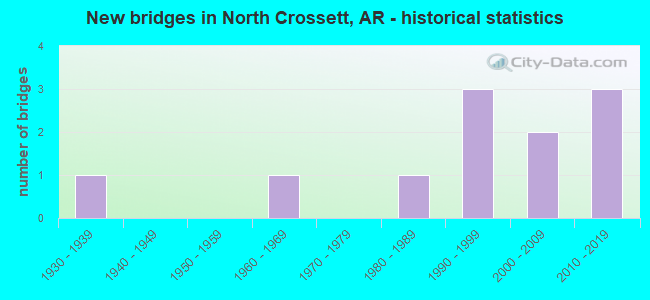
- New bridges - historical statistics
- 11930-1939
- 11960-1969
- 11980-1989
- 31990-1999
- 22000-2009
- 32010-2019


- Bridge Condition - Deck
- 16.7%Excellent
- 33.3%Very good
- 33.3%Good
- 16.7%Fair

- Bridge Condition - Superstructure
- 33.3%Excellent
- 16.7%Very good
- 33.3%Good
- 16.7%Fair

- Bridge Condition - Substructure
- 16.7%Excellent
- 16.7%Very good
- 50.0%Good
- 16.7%Satisfactory

- Bridge Condition - Channel
- 27.3%Very good
- 63.6%Good
- 9.1%Satisfactory

- Bridge Condition - Culverts
- 80.0%Good
- 20.0%Satisfactory
Find on map >> Show street view
Structure Number: 6943, Location: 1.1 Mi N SH 52-Crossett (Lat: 33.181450, Lng: -91.940950), Route carried "on" structure: State highway 133, Year Built: 2004, Status: Open, Structure Length: 4.27m (14.01ft), Average Daily Traffic: 4,200 (year 2018), Truck Traffic: 12%, Average Future Daily Traffic: 4,913 (year 2028), Design Load: HS 20, Features Intersected: Big Brushy Creek
Minimum Vertical Clearance: 30+ m (98+ ft), Kilometerpoint: 5.584, Lanes on structure: 2, Owner: State Highway Agency, Approaching Roadway Width: 11.6m (38.1ft), Material/Design: Concrete, Design/Construction: Tee Beam, Number Of Spans In Main Unit: 4, Length of Maximum Span: 10.6m (34.8ft), Curb-To-Curb Width: 12.2m (40.0ft), Out-to-Out Width: 13.1m (43.0ft)
Condition: Deck: Good, Superstructure: Good, Substructure: Good, Channel: Very good, Operating Rating: 40.8 metric tons, Method Used To Determine Operating Rating: Load Factor (LF), Inventory Rating: 24.5 metric tons, Method Used To Determine Inventory Rating: Load Factor (LF), Structural Evaluation: Equal to present minimum criteria, Deck Geometry: Equal to present minimum criteria, Waterway Adequacy: Equal to present desirable criteria, Approach Roadway Alignment: Equal to present desirable criteria, Designated Inspection Frequency: Every 24 months, Critical Feature Inspection Frequency: Every 24 months, Inspection Date: September 2021, Deck Structure Type: Concrete Cast-file-Place, Wearing Surface/Protective System: Wearing Surface: Monolithic Concrete, Deck Protection: Epoxy Coated Reinforcing
Find on map >> Show street view
Structure Number: 7321, Location: 4.0 Mi E SH 133- Crossett (Lat: 33.135178, Lng: -91.884939), Route carried "on" structure: US 82, Year Built: 2017, Status: Open, Structure Length: 3.23m (10.60ft), Average Daily Traffic: 3,231 (year 2018), Truck Traffic: 15%, Average Future Daily Traffic: 4,200 (year 2036), Design Load: HL 93, Features Intersected: Middle Fork of West Crk
Minimum Vertical Clearance: 30+ m (98+ ft), Kilometerpoint: 22.177, Lanes on structure: 4, Base Highway Network: Yes, Owner: State Highway Agency, Approaching Roadway Width: 22.9m (75.1ft), Material/Design: Steel continuous, Design/Construction: Stringer/Multi-beam, Number Of Spans In Main Unit: 3, Length of Maximum Span: 10.7m (35.1ft), Curb-To-Curb Width: 22.9m (75.1ft), Out-to-Out Width: 23.8m (78.1ft)
Condition: Deck: Very good, Superstructure: Excellent, Substructure: Very good, Channel: Very good, Operating Rating: 41.7 metric tons, Method Used To Determine Operating Rating: Load and Resistance Factor (LRFR), Inventory Rating: 32.7 metric tons, Method Used To Determine Inventory Rating: Load and Resistance Factor (LRFR), Structural Evaluation: Equal to present desirable criteria, Deck Geometry: Superior to present desirable criteria, Waterway Adequacy: Equal to present desirable criteria, Approach Roadway Alignment: Equal to present desirable criteria, Designated Inspection Frequency: Every 24 months, Critical Feature Inspection Frequency: Every 24 months, Inspection Date: March 2021, Deck Structure Type: Concrete Cast-file-Place, Wearing Surface/Protective System: Wearing Surface: Monolithic Concrete, Deck Protection: Epoxy Coated Reinforcing
Find on map >> Show street view
Structure Number: 7322, Location: 4.8 Mi E SH 133-Crossett (Lat: 33.134669, Lng: -91.867758), Route carried "on" structure: US 82, Year Built: 2017, Status: Open, Structure Length: 4.45m (14.60ft), Average Daily Traffic: 3,300 (year 2018), Truck Traffic: 15%, Average Future Daily Traffic: 4,200 (year 2036), Design Load: HL 93, Features Intersected: East Fork of West Creek
Minimum Vertical Clearance: 30+ m (98+ ft), Kilometerpoint: 23.802, Lanes on structure: 4, Base Highway Network: Yes, Owner: State Highway Agency, Approaching Roadway Width: 22.9m (75.1ft), Material/Design: Steel continuous, Design/Construction: Stringer/Multi-beam, Number Of Spans In Main Unit: 3, Length of Maximum Span: 16.8m (55.1ft), Curb-To-Curb Width: 22.9m (75.1ft), Out-to-Out Width: 23.8m (78.1ft)
Condition: Deck: Very good, Superstructure: Excellent, Substructure: Excellent, Channel: Very good, Operating Rating: 33.6 metric tons, Method Used To Determine Operating Rating: Load and Resistance Factor (LRFR), Inventory Rating: 26.3 metric tons, Method Used To Determine Inventory Rating: Load and Resistance Factor (LRFR), Structural Evaluation: Equal to present minimum criteria, Deck Geometry: Superior to present desirable criteria, Waterway Adequacy: Equal to present desirable criteria, Approach Roadway Alignment: Equal to present desirable criteria, Designated Inspection Frequency: Every 24 months, Critical Feature Inspection Frequency: Every 24 months, Inspection Date: March 2021, Deck Structure Type: Concrete Cast-file-Place, Wearing Surface/Protective System: Wearing Surface: Monolithic Concrete, Deck Protection: Epoxy Coated Reinforcing
Find on map >> Show street view
Structure Number: 20749, Location: 0.7 Mi N SH 133-NCrossett (Lat: 33.163342, Lng: -91.951161), Route carried "on" structure: County highway 811, Year Built: 1988, Status: Open, Structure Length: 0.81m (2.66ft), Average Daily Traffic: 535 (year 2018), Truck Traffic: 1%, Average Future Daily Traffic: 656 (year 2007), Features Intersected: Creek
Minimum Vertical Clearance: 30+ m (98+ ft), Kilometerpoint: 1.094, Lanes on structure: 2, Owner: County Highway Agency, Approaching Roadway Width: 5.5m (18.0ft), Material/Design: Steel, Design/Construction: Orthotropic, Number Of Spans In Main Unit: 1, Length of Maximum Span: 7.0m (23.0ft), Curb-To-Curb Width: 6.0m (19.7ft), Out-to-Out Width: 6.0m (19.7ft)
Condition: Deck: Fair, Superstructure: Fair, Substructure: Good, Channel: Good, Operating Rating: 39.0 metric tons, Method Used To Determine Operating Rating: Load Factor (LF), Inventory Rating: 23.6 metric tons, Method Used To Determine Inventory Rating: Load Factor (LF), Structural Evaluation: Somewhat better than minimum adequacy, Deck Geometry: High priority of replacement, Waterway Adequacy: Equal to present desirable criteria, Approach Roadway Alignment: Equal to present desirable criteria, Length Of Structure Improvement: 1.52m (4.99ft), Designated Inspection Frequency: Every 24 months, Critical Feature Inspection Frequency: Every 24 months, Inspection Date: November 2021, Critical Feature Inspection Date: November 2021, Roadway Improvement Cost: $109,000, Total Project Cost: $210,000, Deck Structure Type: Steel plate, Wearing Surface/Protective System: Wearing Surface: Bituminous
Find on map >> Show street view
Structure Number: 21224, Location: 1.6 Mi W SH 133-NCrossett (Lat: 33.160342, Lng: -91.966178), Route carried "on" structure: County highway 10, Year Built: 1992, Status: Open, Structure Length: 1.52m (4.99ft), Average Daily Traffic: 2,286 (year 2018), Truck Traffic: 1%, Average Future Daily Traffic: 1,162 (year 2007), Features Intersected: Little Brushy Creek
Minimum Vertical Clearance: 30+ m (98+ ft), Kilometerpoint: 10.139, Lanes on structure: 2, Owner: County Highway Agency, Approaching Roadway Width: 6.7m (22.0ft), Material/Design: Concrete, Design/Construction: Channel Beam, Number Of Spans In Main Unit: 2, Length of Maximum Span: 9.1m (29.9ft), Curb-To-Curb Width: 6.5m (21.3ft), Out-to-Out Width: 6.5m (21.3ft)
Condition: Deck: Good, Superstructure: Good, Substructure: Satisfactory, Channel: Good, Operating Rating: 45.4 metric tons, Method Used To Determine Operating Rating: Load Factor (LF), Inventory Rating: 27.2 metric tons, Method Used To Determine Inventory Rating: Load Factor (LF), Structural Evaluation: Equal to present minimum criteria, Deck Geometry: High priority of replacement, Waterway Adequacy: Equal to present minimum criteria, Approach Roadway Alignment: Equal to present minimum criteria, Length Of Structure Improvement: 2.26m (7.41ft), Designated Inspection Frequency: Every 24 months, Critical Feature Inspection Frequency: Every 24 months, Inspection Date: March 2021, Roadway Improvement Cost: $109,000, Total Project Cost: $244,000, Deck Structure Type: Concrete Precast Panels, Wearing Surface/Protective System: Wearing Surface: Bituminous
Find on map >> Show street view
Structure Number: 21809, Location: 2.6 Mi W SH 133 (Lat: 33.239844, Lng: -91.967319), Route carried "on" structure: County highway 12, Year Built: 1997, Status: Open, Structure Length: 1.19m (3.90ft), Average Daily Traffic: 1,500 (year 2018), Truck Traffic: 4%, Average Future Daily Traffic: 5 (year 2009), Features Intersected: Creek
Minimum Vertical Clearance: 30+ m (98+ ft), Kilometerpoint: 10.911, Lanes on structure: 2, Owner: County Highway Agency, Approaching Roadway Width: 8.5m (27.9ft), Material/Design: Steel, Design/Construction: Culvert, Number Of Spans In Main Unit: 5, Length of Maximum Span: 1.8m (5.9ft)
Condition: Channel: Good, Culverts: Good, Operating Rating: 54.4 metric tons, Method Used To Determine Operating Rating: Load Factor (LF), Inventory Rating: 32.7 metric tons, Method Used To Determine Inventory Rating: Load Factor (LF), Structural Evaluation: Better than present minimum criteria, Waterway Adequacy: Equal to present minimum criteria, Approach Roadway Alignment: Somewhat better than minimum adequacy, Designated Inspection Frequency: Every 24 months, Critical Feature Inspection Frequency: Every 24 months, Inspection Date: March 2021
Find on map >> Show street view
Structure Number: 2231, Location: 0.2 Mi W SH 133-Crossett (Lat: 33.230472, Lng: -91.927556), Route carried "on" structure: County highway 12, Year Built: 1997, Status: Open, Structure Length: 1.21m (3.97ft), Average Daily Traffic: 1,500 (year 2018), Truck Traffic: 4%, Average Future Daily Traffic: 117 (year 2017), Features Intersected: South Mill Creek
Minimum Vertical Clearance: 30+ m (98+ ft), Kilometerpoint: 14.822, Lanes on structure: 2, Owner: County Highway Agency, Approaching Roadway Width: 8.5m (27.9ft), Material/Design: Steel, Design/Construction: Culvert, Number Of Spans In Main Unit: 5, Length of Maximum Span: 1.8m (5.9ft)
Condition: Channel: Good, Culverts: Good, Operating Rating: 54.4 metric tons, Method Used To Determine Operating Rating: Load Factor (LF), Inventory Rating: 32.7 metric tons, Method Used To Determine Inventory Rating: Load Factor (LF), Structural Evaluation: Better than present minimum criteria, Waterway Adequacy: Equal to present minimum criteria, Approach Roadway Alignment: Equal to present minimum criteria, Designated Inspection Frequency: Every 24 months, Critical Feature Inspection Frequency: Every 24 months, Inspection Date: April 2021
Find on map >> Show street view
Structure Number: 24018, Location: 0.3 Mi N SH 133-NCrossett (Lat: 33.157778, Lng: -91.951147), Route carried "on" structure: County highway 811, Year Built: 2018, Status: Open, Structure Length: 1.59m (5.22ft), Average Daily Traffic: 535 (year 2018), Truck Traffic: 1%, Average Future Daily Traffic: 525 (year 2038), Features Intersected: Little Brushy Creek
Minimum Vertical Clearance: 30+ m (98+ ft), Kilometerpoint: 0.418, Lanes on structure: 2, Owner: County Highway Agency, Approaching Roadway Width: 5.5m (18.0ft), Material/Design: Steel, Design/Construction: Stringer/Multi-beam, Number Of Spans In Main Unit: 1, Length of Maximum Span: 13.4m (44.0ft), Curb-To-Curb Width: 6.2m (20.3ft), Out-to-Out Width: 6.2m (20.3ft)
Condition: Deck: Excellent, Superstructure: Very good, Substructure: Good, Channel: Good, Operating Rating: 39.9 metric tons, Method Used To Determine Operating Rating: Load Factor (LF), Inventory Rating: 24.5 metric tons, Method Used To Determine Inventory Rating: Load Factor (LF), Structural Evaluation: Equal to present minimum criteria, Deck Geometry: High priority of corrective action, Waterway Adequacy: Equal to present desirable criteria, Approach Roadway Alignment: Equal to present desirable criteria, Designated Inspection Frequency: Every 24 months, Critical Feature Inspection Frequency: Every 24 months, Inspection Date: December 2020, Deck Structure Type: Concrete Cast-file-Place, Wearing Surface/Protective System: Wearing Surface: Monolithic Concrete
Find on map >> Show street view
Structure Number: M1527, Location: 1.74 Mi N US 82-Crossett (Lat: 33.157578, Lng: -91.946364), Route carried "on" structure: State highway 133, Year Built: 1930, Year Reconstructed: 1965, Status: Open, Structure Length: 0.70m (2.30ft), Average Daily Traffic: 11,000 (year 2018), Truck Traffic: 1%, Average Future Daily Traffic: 14,038 (year 2027), Design Load: H 15, Features Intersected: Little Brushy Creek
Minimum Vertical Clearance: 30+ m (98+ ft), Kilometerpoint: 2.800, Lanes on structure: 4, Owner: State Highway Agency, Approaching Roadway Width: 10.7m (35.1ft), Material/Design: Concrete, Design/Construction: Culvert, Number Of Spans In Main Unit: 2, Length of Maximum Span: 3.0m (9.8ft)
Condition: Channel: Good, Culverts: Satisfactory, Operating Rating: 26.3 metric tons, Method Used To Determine Operating Rating: Load Factor (LF), Inventory Rating: 16.3 metric tons, Method Used To Determine Inventory Rating: Load Factor (LF), Structural Evaluation: Meets minimum limits, Waterway Adequacy: Equal to present desirable criteria, Approach Roadway Alignment: Equal to present desirable criteria, Designated Inspection Frequency: Every 24 months, Critical Feature Inspection Frequency: Every 24 months, Inspection Date: April 2021
Find on map >> Show street view
Structure Number: M193, Location: 7.42 Mi N US 82-Crossett (Lat: 33.233433, Lng: -91.924514), Route carried "on" structure: State highway 133, Year Built: 1965, Status: Open, Structure Length: 0.63m (2.07ft), Average Daily Traffic: 3,300 (year 2018), Truck Traffic: 15%, Average Future Daily Traffic: 4,913 (year 2027), Design Load: H 15, Features Intersected: Whiteoak Creek
Minimum Vertical Clearance: 30+ m (98+ ft), Kilometerpoint: 11.941, Lanes on structure: 2, Owner: State Highway Agency, Approaching Roadway Width: 10.4m (34.1ft), Material/Design: Concrete, Design/Construction: Culvert, Number Of Spans In Main Unit: 2, Length of Maximum Span: 3.0m (9.8ft)
Condition: Channel: Satisfactory, Culverts: Good, Operating Rating: 39.9 metric tons, Method Used To Determine Operating Rating: Load Factor (LF), Inventory Rating: 23.6 metric tons, Method Used To Determine Inventory Rating: Load Factor (LF), Structural Evaluation: Equal to present minimum criteria, Waterway Adequacy: Equal to present desirable criteria, Approach Roadway Alignment: Equal to present desirable criteria, Designated Inspection Frequency: Every 24 months, Critical Feature Inspection Frequency: Every 24 months, Inspection Date: April 2021
Find on map >> Show street view
Structure Number: X1218, Location: 7.12 Mi N US 82-Crossett (Lat: 33.228969, Lng: -91.924469), Route carried "on" structure: State highway 133, Year Built: 2007, Status: Open, Structure Length: 0.70m (2.30ft), Average Daily Traffic: 4,200 (year 2018), Truck Traffic: 12%, Average Future Daily Traffic: 4,913 (year 2027), Design Load: H 20, Features Intersected: Whiteoak Creek
Minimum Vertical Clearance: 30+ m (98+ ft), Kilometerpoint: 11.459, Lanes on structure: 2, Owner: State Highway Agency, Approaching Roadway Width: 12.5m (41.0ft), Skew: 1 degrees, Material/Design: Concrete, Design/Construction: Culvert, Number Of Spans In Main Unit: 4, Length of Maximum Span: 1.5m (4.9ft)
Condition: Channel: Good, Culverts: Good, Operating Rating: 35.4 metric tons, Method Used To Determine Operating Rating: Load Factor (LF), Inventory Rating: 21.8 metric tons, Method Used To Determine Inventory Rating: Load Factor (LF), Structural Evaluation: Somewhat better than minimum adequacy, Waterway Adequacy: Equal to present desirable criteria, Approach Roadway Alignment: Equal to present desirable criteria, Designated Inspection Frequency: Every 24 months, Critical Feature Inspection Frequency: Every 24 months, Inspection Date: April 2021