Bridge Statistics for North Druid Hills, Georgia (GA)
Condition, Traffic, Stress, Structural Evaluation, Project Costs
- National Bridge Inventory (NBI) Statistics
- 10Number of bridges
- 75ft / 23.4mTotal length
- $10,633,000Total costs
- 311,594Total average daily traffic
- 4,395Total average daily truck traffic
- National Bridge Inventory (NBI) Registered Bridges for North Druid Hills
- No street view available for this location
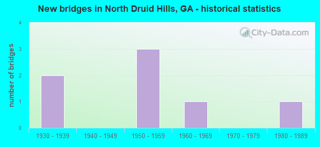
- New bridges - historical statistics
- 21930-1939
- 31950-1959
- 11960-1969
- 11980-1989

- Reconstructed bridges - Historical Statistics
- 11970-1979
- 11980-1989


- Bridge Condition - Deck
- 50.0%Good
- 50.0%Satisfactory

- Bridge Condition - Superstructure
- 50.0%Very good
- 33.3%Good
- 16.7%Satisfactory

- Bridge Condition - Channel
- 20.0%Very good
- 40.0%Good
- 40.0%Fair
Find on map >> Show street view
Structure Number: 890028, Location: 6.4 MI SW OF CHAMBLEE (Lat: 33.805419, Lng: -84.336797), Route carried "on" structure: State highway 42, Year Built: 1939, Year Reconstructed: 1980, Status: Open, Structure Length: 4.33m (14.21ft), Average Daily Traffic: 14,230 (year 2011), Truck Traffic: 10%, Average Future Daily Traffic: 21,345 (year 2031), Design Load: H 15, Features Intersected: CSX RAILROAD, Facility Carried by Structure: BRIARCLIFF ROAD
Minimum Vertical Clearance: 30+ m (98+ ft), Kilometerpoint: 19.312, Lanes on structure: 5, Base Highway Network: Yes, Owner: State Highway Agency, Approaching Roadway Width: 20.1m (65.9ft), Skew: 3 degrees, Material/Design: Steel, Design/Construction: Stringer/Multi-beam, Number Of Spans In Main Unit: 3, Length of Maximum Span: 18.0m (59.1ft), Curb or Sidewalk Widths: Left: 1.8m (5.9ft), Right: 1.8m (5.9ft), Curb-To-Curb Width: 20.1m (65.9ft), Out-to-Out Width: 24.5m (80.4ft)
Condition: Deck: Satisfactory, Superstructure: Very good, Substructure: Good, Operating Rating: 39.9 metric tons, Method Used To Determine Operating Rating: Load Factor (LF), Inventory Rating: 23.5 metric tons, Method Used To Determine Inventory Rating: Load Factor (LF), Structural Evaluation: Somewhat better than minimum adequacy, Deck Geometry: Somewhat better than minimum adequacy, Underclear: Meets minimum limits, Approach Roadway Alignment: Equal to present desirable criteria, Designated Inspection Frequency: Every 24 months, Inspection Date: July 2020, Bridge Improvement Cost: $1,009,000, Roadway Improvement Cost: $101,000, Total Project Cost: $1,513,000, Deck Structure Type: Concrete Cast-file-Place
Find on map >> Show street view
Structure Number: 890064, Location: 3.6 MI S OF CHAMBLEE (Lat: 33.840422, Lng: -84.313217), Route carried "on" structure: Interstate 85, Year Built: 1981, Status: Open, Structure Length: 9.51m (31.20ft), Average Daily Traffic: 200,150 (year 2011), Truck Traffic: 1%, Average Future Daily Traffic: 300,225 (year 2031), Design Load: HS 20+Mod, Features Intersected: SR 155- 2 U-TURNS 3X-REF
Minimum Vertical Clearance: 30+ m (98+ ft), Kilometerpoint: 146.450, Lanes on structure: 12, Lanes under structure: 10, Base Highway Network: Yes, Owner: State Highway Agency, Approaching Roadway Width: 51.2m (168.0ft), Skew: 32 degrees, Material/Design: Steel, Design/Construction: Stringer/Multi-beam, Number Of Spans In Main Unit: 3, Length of Maximum Span: 39.9m (130.9ft), Curb-To-Curb Width: 51.2m (168.0ft), Out-to-Out Width: 52.1m (170.9ft)
Condition: Deck: Good, Superstructure: Very good, Substructure: Good, Operating Rating: 50.8 metric tons, Method Used To Determine Operating Rating: Load Factor (LF), Inventory Rating: 29.9 metric tons, Method Used To Determine Inventory Rating: Load Factor (LF), Structural Evaluation: Better than present minimum criteria, Deck Geometry: Better than present minimum criteria, Underclear: Somewhat better than minimum adequacy, Approach Roadway Alignment: Equal to present desirable criteria, Designated Inspection Frequency: Every 24 months, Inspection Date: June 2020, Bridge Improvement Cost: $4,544,000, Roadway Improvement Cost: $454,000, Total Project Cost: $6,816,000, Deck Structure Type: Concrete Cast-file-Place, Wearing Surface/Protective System: Deck Protection: Epoxy Coated Reinforcing
Find on map >> Show street view
Structure Number: 890171, Location: 3 MI NW OF DECATUR (Lat: 33.803944, Lng: -84.333856), Route carried "on" structure: City street 9198, Year Built: 1960, Year Reconstructed: 1977, Status: Open, Structure Length: 4.42m (14.50ft), Average Daily Traffic: 19,820 (year 2011), Truck Traffic: 1%, Average Future Daily Traffic: 29,730 (year 2031), Design Load: HS 20, Features Intersected: S FORK PEACHTREE CREEK, Facility Carried by Structure: CLIFTON ROAD
Minimum Vertical Clearance: 30+ m (98+ ft), Kilometerpoint: 3.219, Lanes on structure: 4, Base Highway Network: Yes, Owner: County Highway Agency, Approaching Roadway Width: 15.8m (51.8ft), Skew: 3 degrees, Material/Design: Steel, Design/Construction: Stringer/Multi-beam, Number Of Spans In Main Unit: 5, Length of Maximum Span: 8.8m (28.9ft), Curb or Sidewalk Widths: Left: 0.0m, Right: 1.5m (4.9ft), Curb-To-Curb Width: 15.8m (51.8ft), Out-to-Out Width: 18.2m (59.7ft)
Condition: Deck: Satisfactory, Superstructure: Satisfactory, Substructure: Good, Channel: Good, Operating Rating: 46.2 metric tons, Method Used To Determine Operating Rating: Allowable Stress (AS), Inventory Rating: 32.6 metric tons, Method Used To Determine Inventory Rating: Allowable Stress (AS), Structural Evaluation: Equal to present minimum criteria, Deck Geometry: Meets minimum limits, Waterway Adequacy: Equal to present desirable criteria, Approach Roadway Alignment: Equal to present desirable criteria, Designated Inspection Frequency: Every 24 months, Inspection Date: May 2020, Bridge Improvement Cost: $876,000, Roadway Improvement Cost: $88,000, Total Project Cost: $1,313,000, Deck Structure Type: Concrete Cast-file-Place
Find on map >> Show street view
Structure Number: 890229, Location: 4.2 MI SE OF CHAMBLEE (Lat: 33.831456, Lng: -84.323331), Route carried "on" structure: City street 9326, Year Built: 1954, Status: Open, Structure Length: 0.67m (2.20ft), Average Daily Traffic: 11,720 (year 2011), Truck Traffic: 1%, Average Future Daily Traffic: 17,580 (year 2031), Design Load: H 15, Features Intersected: N FORK P'TREE CREEK TRIB, Facility Carried by Structure: BRIARCLIFF ROAD
Minimum Vertical Clearance: 30+ m (98+ ft), Kilometerpoint: 0.000, Lanes on structure: 2, Base Highway Network: Yes, Owner: County Highway Agency, Approaching Roadway Width: 8.2m (26.9ft), Material/Design: Concrete continuous, Design/Construction: Slab, Number Of Spans In Main Unit: 2, Length of Maximum Span: 3.4m (11.2ft), Curb or Sidewalk Widths: Left: 1.2m (3.9ft), Right: 0.0m, Curb-To-Curb Width: 8.8m (28.9ft), Out-to-Out Width: 12.5m (41.0ft)
Condition: Deck: Good, Superstructure: Good, Substructure: Good, Channel: Fair, Operating Rating: 39.0 metric tons, Method Used To Determine Operating Rating: Allowable Stress (AS), Inventory Rating: 23.5 metric tons, Method Used To Determine Inventory Rating: Allowable Stress (AS), Structural Evaluation: Somewhat better than minimum adequacy, Deck Geometry: High priority of replacement, Waterway Adequacy: Equal to present minimum criteria, Approach Roadway Alignment: Equal to present minimum criteria, Length Of Structure Improvement: 41.00m (134.51ft), Designated Inspection Frequency: Every 24 months, Inspection Date: May 2020, Bridge Improvement Cost: $86,000, Roadway Improvement Cost: $9,000, Total Project Cost: $129,000, Deck Structure Type: Concrete Cast-file-Place, Wearing Surface/Protective System: Wearing Surface: Bituminous, Membrane: Built-up
Find on map >> Show street view
Structure Number: 89023, Location: 3.5 MI S OF CHAMBLEE (Lat: 33.837719, Lng: -84.309628), Route carried "on" structure: City street 9326, Year Built: 1954, Status: Open, Structure Length: 0.82m (2.69ft), Average Daily Traffic: 5,970 (year 2011), Truck Traffic: 1%, Average Future Daily Traffic: 8,955 (year 2031), Design Load: H 15, Features Intersected: N FORK P'TREE CREEK TRIB, Facility Carried by Structure: BRIARCLIFF ROAD
Minimum Vertical Clearance: 30+ m (98+ ft), Kilometerpoint: 3.219, Lanes on structure: 2, Base Highway Network: Yes, Owner: County Highway Agency, Approaching Roadway Width: 8.2m (26.9ft), Skew: 9 degrees, Material/Design: Concrete, Design/Construction: Culvert, Number Of Spans In Main Unit: 3, Length of Maximum Span: 2.4m (7.9ft)
Condition: Channel: Fair, Culverts: Good, Operating Rating: 43.5 metric tons, Method Used To Determine Operating Rating: Field evaluation and documented engineering judgment, Inventory Rating: 24.4 metric tons, Method Used To Determine Inventory Rating: Field evaluation and documented engineering judgment, Structural Evaluation: Equal to present minimum criteria, Waterway Adequacy: Equal to present minimum criteria, Approach Roadway Alignment: Equal to present desirable criteria, Designated Inspection Frequency: Every 24 months, Inspection Date: May 2020, Bridge Improvement Cost: $105,000, Roadway Improvement Cost: $11,000, Total Project Cost: $158,000
Find on map >> Show street view
Structure Number: 895046, Location: 3 MI NW OF DECATUR (Lat: 33.803392, Lng: -84.335622), Route carried "on" structure: County highway 5205, Year Built: 1938, Status: Open, Structure Length: 2.93m (9.61ft), Average Daily Traffic: 2,202 (year 2011), Truck Traffic: 1%, Average Future Daily Traffic: 3,303 (year 2031), Design Load: H 10, Features Intersected: S FORK PEACHTREE CREEK, Facility Carried by Structure: OLD BRIARCLIFF RD.
Minimum Vertical Clearance: 30+ m (98+ ft), Kilometerpoint: 0.000, Lanes on structure: 2, Base Highway Network: Yes, Owner: County Highway Agency, Approaching Roadway Width: 6.1m (20.0ft), Material/Design: Steel continuous, Design/Construction: Stringer/Multi-beam, Number Of Spans In Main Unit: 3, Length of Maximum Span: 11.9m (39.0ft), Curb-To-Curb Width: 5.5m (18.0ft), Out-to-Out Width: 6.2m (20.3ft)
Condition: Deck: Satisfactory, Superstructure: Very good, Substructure: Good, Channel: Very good, Operating Rating: 56.2 metric tons, Method Used To Determine Operating Rating: Load Factor (LF), Inventory Rating: 33.5 metric tons, Method Used To Determine Inventory Rating: Load Factor (LF), Structural Evaluation: Better than present minimum criteria, Deck Geometry: High priority of replacement, Waterway Adequacy: Equal to present desirable criteria, Approach Roadway Alignment: Meets minimum limits, Length Of Structure Improvement: 43.22m (141.80ft), Designated Inspection Frequency: Every 24 months, Inspection Date: May 2020, Bridge Improvement Cost: $375,000, Roadway Improvement Cost: $38,000, Total Project Cost: $563,000, Deck Structure Type: Concrete Cast-file-Place
Find on map >> Show street view
Structure Number: 895047, Location: 5 MI S OF CHAMBLEE (Lat: 33.835444, Lng: -84.307569), Route carried "on" structure: County highway 1481, Year Built: 1951, Status: Open, Structure Length: 0.73m (2.40ft), Average Daily Traffic: 2,202 (year 2011), Truck Traffic: 1%, Average Future Daily Traffic: 3,303 (year 2031), Design Load: H 15, Features Intersected: N FORK P'TREE CREEK TRIB, Facility Carried by Structure: WOODBINE TERR.
Minimum Vertical Clearance: 30+ m (98+ ft), Kilometerpoint: 0.000, Lanes on structure: 2, Base Highway Network: Yes, Owner: County Highway Agency, Approaching Roadway Width: 7.9m (25.9ft), Material/Design: Concrete, Design/Construction: Slab, Number Of Spans In Main Unit: 2, Length of Maximum Span: 3.7m (12.1ft), Curb or Sidewalk Widths: Left: 1.1m (3.6ft), Right: 1.2m (3.9ft), Curb-To-Curb Width: 7.9m (25.9ft), Out-to-Out Width: 10.6m (34.8ft)
Condition: Deck: Good, Superstructure: Good, Substructure: Good, Channel: Good, Operating Rating: 35.3 metric tons, Method Used To Determine Operating Rating: Allowable Stress (AS), Inventory Rating: 23.5 metric tons, Method Used To Determine Inventory Rating: Allowable Stress (AS), Structural Evaluation: Equal to present minimum criteria, Deck Geometry: High priority of corrective action, Waterway Adequacy: Equal to present minimum criteria, Approach Roadway Alignment: Better than present minimum criteria, Length Of Structure Improvement: 7.19m (23.59ft), Designated Inspection Frequency: Every 24 months, Inspection Date: May 2020, Bridge Improvement Cost: $94,000, Roadway Improvement Cost: $9,000, Total Project Cost: $141,000, Deck Structure Type: Concrete Cast-file-Place, Wearing Surface/Protective System: Wearing Surface: Bituminous
Find on map >> Show street view
Structure Number: 890064, Location: 3.6 MI S OF CHAMBLEE (Lat: 33.840422, Lng: -84.313217), Route carried "under" structure: Ramp Interstate 85, Structure Length: 0. m, Average Daily Traffic: 3,700 (year 1996), Truck Traffic: 1%, Features Intersected: I-85
Minimum Vertical Clearance: 5.41m (17.75ft), Kilometerpoint: 146.450, Lanes on structure: 12, Length of Maximum Span: 0.0m
Find on map >> Show street view
Structure Number: 890064, Location: 3.6 MI S OF CHAMBLEE (Lat: 33.840422, Lng: -84.313217), Route carried "under" structure: US 23, Structure Length: 0. m, Average Daily Traffic: 48,100 (year 1999), Truck Traffic: 1%, Features Intersected: I-85, Facility Carried by Structure: I-85
Minimum Vertical Clearance: 6.24m (20.47ft), Kilometerpoint: 30.578, Lanes on structure: 12, Length of Maximum Span: 0.0m
Find on map >> Show street view
Structure Number: 890064, Location: 3.6 MI S OF CHAMBLEE (Lat: 33.840422, Lng: -84.313217), Route carried "under" structure: Ramp Interstate 85, Structure Length: 0. m, Average Daily Traffic: 3,500 (year 1996), Truck Traffic: 1%, Features Intersected: I-85
Minimum Vertical Clearance: 6.60m (21.65ft), Kilometerpoint: 146.450, Lanes on structure: 12, Length of Maximum Span: 0.0m