Bridge Statistics for North Merrick, New York (NY)
Condition, Traffic, Stress, Structural Evaluation, Project Costs
- National Bridge Inventory (NBI) Statistics
- 25Number of bridges
- 92ft / 28.1mTotal length
- $73,009,000Total costs
- 2,343,126Total average daily traffic
- 10,450Total average daily truck traffic
- National Bridge Inventory (NBI) Registered Bridges for North Merrick
- No street view available for this location
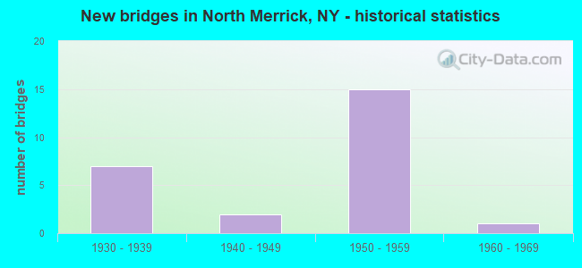
- New bridges - historical statistics
- 71930-1939
- 21940-1949
- 151950-1959
- 11960-1969
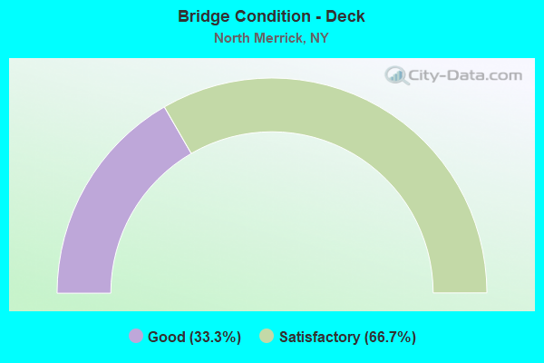
- Bridge Condition - Deck
- 33.3%Good
- 66.7%Satisfactory
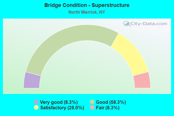
- Bridge Condition - Superstructure
- 8.3%Very good
- 58.3%Good
- 25.0%Satisfactory
- 8.3%Fair
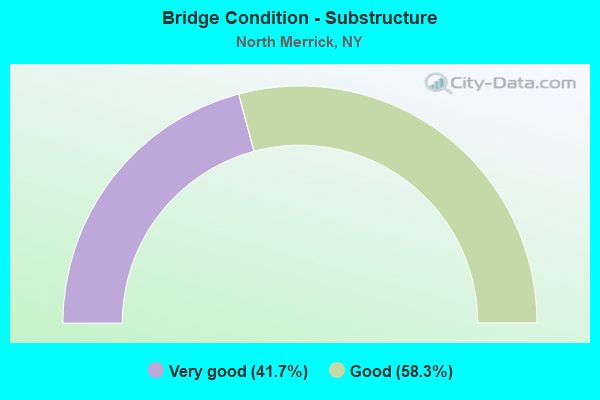
- Bridge Condition - Substructure
- 41.7%Very good
- 58.3%Good
Find on map >> Show street view
Structure Number: 1056549, Location: 3 MI W JCT RTS SSP+WSP (Lat: 40.690358, Lng: -73.572697), Route carried "on" structure: State highway 908M, Year Built: 1956, Status: Open, Structure Length: 1.04m (3.41ft), Average Daily Traffic: 140,951 (year 2018), Truck Traffic: 1%, Average Future Daily Traffic: 167,661 (year 2040), Design Load: HS 20, Features Intersected: EAST MEADOW BROOK
Minimum Vertical Clearance: 30+ m (98+ ft), Kilometerpoint: 14.191, Lanes on structure: 9, Base Highway Network: Yes, Owner: State Highway Agency, Approaching Roadway Width: 38.1m (125.0ft), Skew: 22 degrees, Material/Design: Concrete continuous, Design/Construction: Culvert, Number Of Spans In Main Unit: 3, Length of Maximum Span: 3.3m (10.8ft)
Condition: Channel: Satisfactory, Culverts: Satisfactory, Operating Rating: 38.1 metric tons, Method Used To Determine Operating Rating: Load Factor (LF), Inventory Rating: 22.7 metric tons, Method Used To Determine Inventory Rating: Load Factor (LF), Structural Evaluation: Somewhat better than minimum adequacy, Waterway Adequacy: High priority of replacement, Approach Roadway Alignment: Equal to present desirable criteria, Length Of Structure Improvement: 1.03m (3.38ft), Designated Inspection Frequency: Every 24 months, Inspection Date: August 2021, Bridge Improvement Cost: $5,815,000, Roadway Improvement Cost: $3,405,000, Total Project Cost: $9,220,000 ( Estimate for 2021)
Find on map >> Show street view
Structure Number: 1056612, Location: AT FREEPORT-S OF SSP (Lat: 40.684492, Lng: -73.572442), Route carried "on" structure: State highway 908E, Year Built: 1963, Status: Open, Structure Length: 1.01m (3.31ft), Average Daily Traffic: 42,046 (year 2018), Truck Traffic: 1%, Average Future Daily Traffic: 50,013 (year 2040), Design Load: HS 20, Features Intersected: EAST MEADOW BROOK
Minimum Vertical Clearance: 30+ m (98+ ft), Kilometerpoint: 10.362, Lanes on structure: 3, Base Highway Network: Yes, Owner: State Highway Agency, Approaching Roadway Width: 12.2m (40.0ft), Skew: 2 degrees, Material/Design: Concrete continuous, Design/Construction: Culvert, Number Of Spans In Main Unit: 3, Length of Maximum Span: 3.0m (9.8ft), Curb or Sidewalk Widths: Left: 0.6m (2.0ft), Right: 1.4m (4.6ft), Curb-To-Curb Width: 12.2m (40.0ft), Out-to-Out Width: 16.0m (52.5ft)
Condition: Channel: Satisfactory, Culverts: Satisfactory, Operating Rating: 48.1 metric tons, Method Used To Determine Operating Rating: Load Factor (LF), Inventory Rating: 29.0 metric tons, Method Used To Determine Inventory Rating: Load Factor (LF), Structural Evaluation: Equal to present minimum criteria, Deck Geometry: High priority of replacement, Waterway Adequacy: Meets minimum limits, Approach Roadway Alignment: Better than present minimum criteria, Length Of Structure Improvement: 1.00m (3.28ft), Designated Inspection Frequency: Every 24 months, Inspection Date: August 2021, Bridge Improvement Cost: $741,000, Roadway Improvement Cost: $434,000, Total Project Cost: $1,175,000 ( Estimate for 2021), Wearing Surface/Protective System: Wearing Surface: Bituminous, Membrane: Preformed Fabric
Find on map >> Show street view
Structure Number: 1057579, Location: 3 MI W JCT RTS SSP&WSP (Lat: 40.690836, Lng: -73.575017), Route carried "on" structure: State highway 908E, Year Built: 1955, Status: Open, Structure Length: 2.04m (6.69ft), Average Daily Traffic: 107,132 (year 2018), Truck Traffic: 1%, Average Future Daily Traffic: 127,433 (year 2040), Design Load: HS 20, Features Intersected: RTE 908M
Minimum Vertical Clearance: 30+ m (98+ ft), Kilometerpoint: 11.102, Lanes on structure: 7, Lanes under structure: 3, Base Highway Network: Yes, Owner: State Highway Agency, Approaching Roadway Width: 29.6m (97.1ft), Skew: 21 degrees, Material/Design: Concrete, Design/Construction: Frame, Number Of Spans In Main Unit: 1, Length of Maximum Span: 18.5m (60.7ft), Curb-To-Curb Width: 29.6m (97.1ft), Out-to-Out Width: 32.3m (106.0ft)
Condition: Deck: Satisfactory, Superstructure: Good, Substructure: Very good, Operating Rating: 85.8 metric tons, Method Used To Determine Operating Rating: Field evaluation and documented engineering judgment, Inventory Rating: 32.7 metric tons, Method Used To Determine Inventory Rating: Field evaluation and documented engineering judgment, Structural Evaluation: Better than present minimum criteria, Deck Geometry: Meets minimum limits, Underclear: High priority of corrective action, Approach Roadway Alignment: Equal to present desirable criteria, Length Of Structure Improvement: 2.04m (6.69ft), Designated Inspection Frequency: Every 24 months, Inspection Date: January 2021, Bridge Improvement Cost: $4,645,000, Roadway Improvement Cost: $2,720,000, Total Project Cost: $7,366,000 ( Estimate for 2021), Wearing Surface/Protective System: Wearing Surface: Bituminous, Membrane: Preformed Fabric
Find on map >> Show street view
Structure Number: 1059239, Location: SW OF E MEADOW, N OF SSP (Lat: 40.694456, Lng: -73.576111), Route carried "on" structure: County highway , Year Built: 1955, Status: Open, Structure Length: 2.99m (9.81ft), Average Daily Traffic: 16,112 (year 2018), Truck Traffic: 5%, Average Future Daily Traffic: 19,572 (year 2040), Design Load: HS 20, Features Intersected: 908E908E03011072, N/B, R, Facility Carried by Structure: JERUSALEM AVENUE
Minimum Vertical Clearance: 30+ m (98+ ft), Kilometerpoint: 3.733, Lanes on structure: 5, Lanes under structure: 6, Owner: State Highway Agency, Approaching Roadway Width: 17.7m (58.1ft), Material/Design: Concrete continuous, Design/Construction: Frame, Number Of Spans In Main Unit: 2, Length of Maximum Span: 13.4m (44.0ft), Curb or Sidewalk Widths: Left: 2.4m (7.9ft), Right: 2.4m (7.9ft), Curb-To-Curb Width: 17.7m (58.1ft), Out-to-Out Width: 23.5m (77.1ft)
Condition: Deck: Good, Superstructure: Good, Substructure: Good, Operating Rating: 82.1 metric tons, Method Used To Determine Operating Rating: Field evaluation and documented engineering judgment, Inventory Rating: 32.7 metric tons, Method Used To Determine Inventory Rating: Field evaluation and documented engineering judgment, Structural Evaluation: Better than present minimum criteria, Deck Geometry: High priority of replacement, Underclear: High priority of corrective action, Approach Roadway Alignment: Equal to present desirable criteria, Length Of Structure Improvement: 2.98m (9.78ft), Designated Inspection Frequency: Every 24 months, Inspection Date: January 2021, Bridge Improvement Cost: $3,686,000, Roadway Improvement Cost: $2,159,000, Total Project Cost: $5,845,000 ( Estimate for 2021), Wearing Surface/Protective System: Wearing Surface: Bituminous, Membrane: Other
Find on map >> Show street view
Structure Number: 1059579, Location: 3 MI W JCT RTS SSP+WSP (Lat: 40.690625, Lng: -73.574806), Route carried "on" structure: State highway 908E, Year Built: 1955, Status: Open, Structure Length: 2.41m (7.91ft), Average Daily Traffic: 107,132 (year 2018), Truck Traffic: 1%, Average Future Daily Traffic: 127,433 (year 2040), Design Load: HS 20, Features Intersected: RTE 908M
Minimum Vertical Clearance: 30+ m (98+ ft), Kilometerpoint: 11.054, Lanes on structure: 7, Lanes under structure: 4, Base Highway Network: Yes, Owner: State Highway Agency, Approaching Roadway Width: 29.6m (97.1ft), Skew: 21 degrees, Material/Design: Concrete, Design/Construction: Frame, Number Of Spans In Main Unit: 1, Length of Maximum Span: 20.7m (67.9ft), Curb-To-Curb Width: 29.6m (97.1ft), Out-to-Out Width: 32.3m (106.0ft)
Condition: Deck: Satisfactory, Superstructure: Good, Substructure: Very good, Operating Rating: 87.4 metric tons, Method Used To Determine Operating Rating: Field evaluation and documented engineering judgment, Inventory Rating: 32.7 metric tons, Method Used To Determine Inventory Rating: Field evaluation and documented engineering judgment, Structural Evaluation: Better than present minimum criteria, Deck Geometry: Meets minimum limits, Underclear: High priority of corrective action, Approach Roadway Alignment: Equal to present desirable criteria, Length Of Structure Improvement: 2.40m (7.87ft), Designated Inspection Frequency: Every 24 months, Inspection Date: March 2021, Bridge Improvement Cost: $4,891,000, Roadway Improvement Cost: $2,864,000, Total Project Cost: $7,755,000 ( Estimate for 2021), Wearing Surface/Protective System: Wearing Surface: Bituminous, Membrane: Preformed Fabric
Find on map >> Show street view
Structure Number: 105958, Location: 2.6 MI W JCT SSP & WSP (Lat: 40.689658, Lng: -73.567600), Route carried "on" structure: Other road , Year Built: 1956, Status: Open, Structure Length: 2.29m (7.51ft), Average Daily Traffic: 9,644 (year 2020), Truck Traffic: 4%, Average Future Daily Traffic: 11,715 (year 2040), Design Load: HS 20, Features Intersected: RTE 908M, Facility Carried by Structure: MEADOWBROOK ROAD
Minimum Vertical Clearance: 30+ m (98+ ft), Kilometerpoint: 2.832, Lanes on structure: 2, Lanes under structure: 4, Owner: State Highway Agency, Approaching Roadway Width: 12.8m (42.0ft), Material/Design: Concrete, Design/Construction: Arch - Deck, Number Of Spans In Main Unit: 1, Length of Maximum Span: 21.0m (68.9ft), Curb or Sidewalk Widths: Left: 1.2m (3.9ft), Right: 1.2m (3.9ft), Curb-To-Curb Width: 12.8m (42.0ft), Out-to-Out Width: 16.2m (53.1ft)
Condition: Superstructure: Good, Substructure: Very good, Operating Rating: 87.5 metric tons, Method Used To Determine Operating Rating: Field evaluation and documented engineering judgment, Inventory Rating: 32.7 metric tons, Method Used To Determine Inventory Rating: Field evaluation and documented engineering judgment, Structural Evaluation: Better than present minimum criteria, Deck Geometry: Somewhat better than minimum adequacy, Underclear: High priority of corrective action, Approach Roadway Alignment: Equal to present desirable criteria, Length Of Structure Improvement: 2.28m (7.48ft), Designated Inspection Frequency: Every 24 months, Inspection Date: September 2020, Bridge Improvement Cost: $2,885,000, Roadway Improvement Cost: $1,689,000, Total Project Cost: $4,574,000 ( Estimate for 2021), Wearing Surface/Protective System: Wearing Surface: Bituminous, Membrane: Preformed Fabric
Find on map >> Show street view
Structure Number: 105959, Location: 2.4 MI W JCT SSP & WSP (Lat: 40.689831, Lng: -73.562889), Route carried "on" structure: County highway , Year Built: 1956, Status: Open, Structure Length: 2.32m (7.61ft), Average Daily Traffic: 17,178 (year 2019), Truck Traffic: 3%, Average Future Daily Traffic: 20,867 (year 2040), Design Load: HS 20, Features Intersected: RTE 908M, Facility Carried by Structure: MERRICK AVENUE
Minimum Vertical Clearance: 30+ m (98+ ft), Kilometerpoint: 3.862, Lanes on structure: 4, Lanes under structure: 4, Owner: State Highway Agency, Approaching Roadway Width: 16.2m (53.1ft), Skew: 1 degrees, Material/Design: Concrete, Design/Construction: Arch - Deck, Number Of Spans In Main Unit: 1, Length of Maximum Span: 21.6m (70.9ft), Curb or Sidewalk Widths: Left: 1.2m (3.9ft), Right: 1.2m (3.9ft), Curb-To-Curb Width: 16.2m (53.1ft), Out-to-Out Width: 21.0m (68.9ft)
Condition: Superstructure: Good, Substructure: Good, Operating Rating: 88.0 metric tons, Method Used To Determine Operating Rating: Field evaluation and documented engineering judgment, Inventory Rating: 32.7 metric tons, Method Used To Determine Inventory Rating: Field evaluation and documented engineering judgment, Structural Evaluation: Better than present minimum criteria, Deck Geometry: Meets minimum limits, Underclear: High priority of corrective action, Approach Roadway Alignment: Equal to present desirable criteria, Length Of Structure Improvement: 2.31m (7.58ft), Designated Inspection Frequency: Every 24 months, Inspection Date: June 2021, Bridge Improvement Cost: $3,817,000, Roadway Improvement Cost: $2,235,000, Total Project Cost: $6,052,000 ( Estimate for 2021), Wearing Surface/Protective System: Wearing Surface: Bituminous, Membrane: Preformed Fabric
Find on map >> Show street view
Structure Number: 1059601, Location: 1.9 MI W JCT SSP + WSP (Lat: 40.690708, Lng: -73.553150), Route carried "on" structure: State highway 908M, Year Built: 1956, Status: Open, Structure Length: 2.68m (8.79ft), Average Daily Traffic: 76,227 (year 2020), Truck Traffic: 2%, Average Future Daily Traffic: 90,672 (year 2040), Design Load: HS 20, Features Intersected: JERUSALEM AVENUE
Minimum Vertical Clearance: 30+ m (98+ ft), Kilometerpoint: 15.961, Lanes on structure: 3, Lanes under structure: 4, Base Highway Network: Yes, Owner: State Highway Agency, Approaching Roadway Width: 15.5m (50.9ft), Skew: 4 degrees, Material/Design: Concrete, Design/Construction: Frame, Number Of Spans In Main Unit: 1, Length of Maximum Span: 23.7m (77.8ft), Curb or Sidewalk Widths: Left: 0.0m, Right: 1.8m (5.9ft), Curb-To-Curb Width: 15.6m (51.2ft), Out-to-Out Width: 17.5m (57.4ft)
Condition: Deck: Satisfactory, Superstructure: Satisfactory, Substructure: Good, Operating Rating: 89.5 metric tons, Method Used To Determine Operating Rating: Field evaluation and documented engineering judgment, Inventory Rating: 32.7 metric tons, Method Used To Determine Inventory Rating: Field evaluation and documented engineering judgment, Structural Evaluation: Equal to present minimum criteria, Deck Geometry: Somewhat better than minimum adequacy, Underclear: High priority of corrective action, Approach Roadway Alignment: Equal to present desirable criteria, Length Of Structure Improvement: 2.68m (8.79ft), Designated Inspection Frequency: Every 24 months, Inspection Date: September 2020, Bridge Improvement Cost: $3,137,000, Roadway Improvement Cost: $1,837,000, Total Project Cost: $4,975,000 ( Estimate for 2021), Wearing Surface/Protective System: Wearing Surface: Bituminous, Membrane: Preformed Fabric
Find on map >> Show street view
Structure Number: 1059602, Location: 1.9 MI W JCT RTS SSP+WSP (Lat: 40.690625, Lng: -73.552556), Route carried "on" structure: State highway 908M, Year Built: 1930, Status: Open, Structure Length: 1.98m (6.50ft), Average Daily Traffic: 76,227 (year 2020), Truck Traffic: 2%, Average Future Daily Traffic: 90,672 (year 2040), Features Intersected: JERUSALEM AVENUE
Minimum Vertical Clearance: 30+ m (98+ ft), Kilometerpoint: 15.961, Lanes on structure: 3, Lanes under structure: 4, Base Highway Network: Yes, Owner: State Highway Agency, Approaching Roadway Width: 14.0m (45.9ft), Skew: 3 degrees, Material/Design: Concrete, Design/Construction: Frame, Number Of Spans In Main Unit: 1, Length of Maximum Span: 18.5m (60.7ft), Curb-To-Curb Width: 14.0m (45.9ft), Out-to-Out Width: 16.2m (53.1ft)
Condition: Deck: Satisfactory, Superstructure: Satisfactory, Substructure: Good, Operating Rating: 57.0 metric tons, Method Used To Determine Operating Rating: Field evaluation and documented engineering judgment, Inventory Rating: 22.6 metric tons, Method Used To Determine Inventory Rating: Field evaluation and documented engineering judgment, Structural Evaluation: Somewhat better than minimum adequacy, Deck Geometry: Meets minimum limits, Underclear: High priority of corrective action, Approach Roadway Alignment: Equal to present desirable criteria, Length Of Structure Improvement: 1.98m (6.50ft), Designated Inspection Frequency: Every 24 months, Inspection Date: September 2020, Bridge Improvement Cost: $2,089,000, Roadway Improvement Cost: $1,223,000, Total Project Cost: $3,312,000 ( Estimate for 2021), Wearing Surface/Protective System: Wearing Surface: Bituminous, Membrane: Preformed Fabric
Find on map >> Show street view
Structure Number: 105962, Location: 1.7 MI W JCT SSP & WSP (Lat: 40.692242, Lng: -73.550472), Route carried "on" structure: County highway , Year Built: 1930, Status: Open, Structure Length: 1.98m (6.50ft), Average Daily Traffic: 10,229 (year 2017), Truck Traffic: 3%, Average Future Daily Traffic: 12,426 (year 2040), Features Intersected: RTE 908M, Facility Carried by Structure: BELLMORE AVENUE
Minimum Vertical Clearance: 30+ m (98+ ft), Kilometerpoint: 3.990, Lanes on structure: 4, Lanes under structure: 3, Owner: State Highway Agency, Approaching Roadway Width: 12.8m (42.0ft), Material/Design: Concrete, Design/Construction: Arch - Deck, Number Of Spans In Main Unit: 1, Length of Maximum Span: 17.6m (57.7ft), Curb or Sidewalk Widths: Left: 1.0m (3.3ft), Right: 0.9m (3.0ft), Curb-To-Curb Width: 12.8m (42.0ft), Out-to-Out Width: 16.2m (53.1ft)
Condition: Superstructure: Very good, Substructure: Very good, Operating Rating: 55.2 metric tons, Method Used To Determine Operating Rating: Field evaluation and documented engineering judgment, Inventory Rating: 20.1 metric tons, Method Used To Determine Inventory Rating: Field evaluation and documented engineering judgment, Structural Evaluation: Somewhat better than minimum adequacy, Deck Geometry: High priority of replacement, Underclear: High priority of corrective action, Approach Roadway Alignment: Equal to present desirable criteria, Length Of Structure Improvement: 1.98m (6.50ft), Designated Inspection Frequency: Every 24 months, Inspection Date: July 2021, Bridge Improvement Cost: $2,568,000, Roadway Improvement Cost: $1,504,000, Total Project Cost: $4,072,000 ( Estimate for 2021), Wearing Surface/Protective System: Wearing Surface: Bituminous
Find on map >> Show street view
Structure Number: 107787, Location: .3 MI N INT MSP & SSP (Lat: 40.694653, Lng: -73.574906), Route carried "on" structure: County highway , Year Built: 1936, Year Reconstructed: 1954, Status: Open, Structure Length: 0.91m (2.99ft), Average Daily Traffic: 7,151 (year 2019), Truck Traffic: 3%, Average Future Daily Traffic: 8,687 (year 2040), Design Load: H 20, Features Intersected: EAST MEADOW BROOK, Facility Carried by Structure: JERUSALEM AVENUE
Minimum Vertical Clearance: 30+ m (98+ ft), Kilometerpoint: 0.016, Lanes on structure: 5, Owner: State Highway Agency, Approaching Roadway Width: 17.7m (58.1ft), Skew: 2 degrees, Material/Design: Steel, Design/Construction: Stringer/Multi-beam, Number Of Spans In Main Unit: 1, Length of Maximum Span: 8.2m (26.9ft), Curb or Sidewalk Widths: Left: 1.2m (3.9ft), Right: 1.2m (3.9ft), Curb-To-Curb Width: 17.7m (58.1ft), Out-to-Out Width: 38.3m (125.7ft)
Condition: Deck: Good, Superstructure: Fair, Substructure: Good, Channel: Satisfactory, Operating Rating: 69.0 metric tons, Method Used To Determine Operating Rating: Field evaluation and documented engineering judgment, Inventory Rating: 29.8 metric tons, Method Used To Determine Inventory Rating: Field evaluation and documented engineering judgment, Structural Evaluation: Somewhat better than minimum adequacy, Deck Geometry: High priority of replacement, Waterway Adequacy: Meets minimum limits, Approach Roadway Alignment: Equal to present desirable criteria, Length Of Structure Improvement: 0.91m (2.99ft), Designated Inspection Frequency: Every 24 months, Inspection Date: October 2021, Bridge Improvement Cost: $3,311,000, Roadway Improvement Cost: $1,939,000, Total Project Cost: $5,250,000 ( Estimate for 2021), Deck Structure Type: Concrete Cast-file-Place, Wearing Surface/Protective System: Wearing Surface: Bituminous
Find on map >> Show street view
Structure Number: 15203, Location: 2.6 MI W JCT SSP & WSP (Lat: 40.689869, Lng: -73.567606), Route carried "on" structure: Other road , Year Built: 1940, Status: Open, Structure Length: 1.98m (6.50ft), Average Daily Traffic: 9,644 (year 2020), Truck Traffic: 4%, Average Future Daily Traffic: 13,502 (year 2040), Design Load: H 20, Features Intersected: RTE 908M, Facility Carried by Structure: MEADOWBROOK ROAD
Minimum Vertical Clearance: 30+ m (98+ ft), Kilometerpoint: 2.864, Lanes on structure: 2, Lanes under structure: 3, Owner: State Highway Agency, Approaching Roadway Width: 12.8m (42.0ft), Material/Design: Concrete, Design/Construction: Arch - Deck, Number Of Spans In Main Unit: 1, Length of Maximum Span: 17.6m (57.7ft), Curb or Sidewalk Widths: Left: 1.2m (3.9ft), Right: 1.2m (3.9ft), Curb-To-Curb Width: 12.8m (42.0ft), Out-to-Out Width: 16.2m (53.1ft)
Condition: Superstructure: Good, Substructure: Very good, Operating Rating: 56.1 metric tons, Method Used To Determine Operating Rating: Field evaluation and documented engineering judgment, Inventory Rating: 22.4 metric tons, Method Used To Determine Inventory Rating: Field evaluation and documented engineering judgment, Structural Evaluation: Somewhat better than minimum adequacy, Deck Geometry: Somewhat better than minimum adequacy, Underclear: High priority of corrective action, Approach Roadway Alignment: Equal to present desirable criteria, Length Of Structure Improvement: 1.98m (6.50ft), Designated Inspection Frequency: Every 24 months, Inspection Date: September 2020, Bridge Improvement Cost: $2,423,000, Roadway Improvement Cost: $1,419,000, Total Project Cost: $3,841,000 ( Estimate for 2021), Wearing Surface/Protective System: Wearing Surface: Bituminous, Membrane: Preformed Fabric
Find on map >> Show street view
Structure Number: 152031, Location: 2.4 MI W JCT SSP & WSP (Lat: 40.690119, Lng: -73.563008), Route carried "on" structure: County highway , Year Built: 1930, Status: Open, Structure Length: 2.23m (7.32ft), Average Daily Traffic: 17,178 (year 2019), Truck Traffic: 3%, Average Future Daily Traffic: 20,867 (year 2040), Features Intersected: RTE 908M, Facility Carried by Structure: MERRICK AVENUE
Minimum Vertical Clearance: 30+ m (98+ ft), Kilometerpoint: 3.910, Lanes on structure: 4, Lanes under structure: 3, Owner: State Highway Agency, Approaching Roadway Width: 16.2m (53.1ft), Skew: 1 degrees, Material/Design: Concrete, Design/Construction: Arch - Deck, Number Of Spans In Main Unit: 1, Length of Maximum Span: 20.4m (66.9ft), Curb or Sidewalk Widths: Left: 1.2m (3.9ft), Right: 1.2m (3.9ft), Curb-To-Curb Width: 16.2m (53.1ft), Out-to-Out Width: 21.0m (68.9ft)
Condition: Superstructure: Satisfactory, Substructure: Good, Operating Rating: 58.2 metric tons, Method Used To Determine Operating Rating: Field evaluation and documented engineering judgment, Inventory Rating: 20.8 metric tons, Method Used To Determine Inventory Rating: Field evaluation and documented engineering judgment, Structural Evaluation: Somewhat better than minimum adequacy, Deck Geometry: Meets minimum limits, Underclear: High priority of corrective action, Approach Roadway Alignment: Equal to present desirable criteria, Length Of Structure Improvement: 2.22m (7.28ft), Designated Inspection Frequency: Every 24 months, Inspection Date: June 2021, Bridge Improvement Cost: $3,151,000, Roadway Improvement Cost: $1,845,000, Total Project Cost: $4,997,000 ( Estimate for 2021), Wearing Surface/Protective System: Wearing Surface: Bituminous, Membrane: Preformed Fabric
Find on map >> Show street view
Structure Number: 152032, Location: 1.7 MI W JCT SSP & WSP (Lat: 40.692439, Lng: -73.550717), Route carried "on" structure: County highway , Year Built: 1956, Status: Open, Structure Length: 2.29m (7.51ft), Average Daily Traffic: 10,229 (year 2017), Truck Traffic: 3%, Average Future Daily Traffic: 12,426 (year 2040), Design Load: HS 20, Features Intersected: RTE 908M, Facility Carried by Structure: BELLMORE AVENUE
Minimum Vertical Clearance: 30+ m (98+ ft), Kilometerpoint: 4.023, Lanes on structure: 4, Lanes under structure: 3, Owner: State Highway Agency, Approaching Roadway Width: 12.8m (42.0ft), Material/Design: Concrete, Design/Construction: Arch - Deck, Number Of Spans In Main Unit: 1, Length of Maximum Span: 21.0m (68.9ft), Curb or Sidewalk Widths: Left: 1.0m (3.3ft), Right: 0.9m (3.0ft), Curb-To-Curb Width: 12.8m (42.0ft), Out-to-Out Width: 16.2m (53.1ft)
Condition: Superstructure: Good, Substructure: Good, Operating Rating: 87.5 metric tons, Method Used To Determine Operating Rating: Field evaluation and documented engineering judgment, Inventory Rating: 32.7 metric tons, Method Used To Determine Inventory Rating: Field evaluation and documented engineering judgment, Structural Evaluation: Better than present minimum criteria, Deck Geometry: High priority of replacement, Underclear: High priority of corrective action, Approach Roadway Alignment: Equal to present desirable criteria, Length Of Structure Improvement: 2.28m (7.48ft), Designated Inspection Frequency: Every 24 months, Inspection Date: July 2021, Bridge Improvement Cost: $2,885,000, Roadway Improvement Cost: $1,689,000, Total Project Cost: $4,575,000 ( Estimate for 2021), Wearing Surface/Protective System: Wearing Surface: Bituminous
Find on map >> Show street view
Structure Number: 1057579, Location: 3 MI W JCT RTS SSP&WSP (Lat: 40.690836, Lng: -73.575017), Route carried "under" structure: State highway 908M, Year Built: 1955, Structure Length: 0. m, Average Daily Traffic: 196,227 (year 2002), Features Intersected: RTE 908M, Facility Carried by Structure: RTE 908E
Minimum Vertical Clearance: 4.11m (13.48ft), Kilometerpoint: 14.095, Lanes on structure: 7, Lanes under structure: 3, Material/Design: Concrete, Design/Construction: Frame, Length of Maximum Span: 18.5m (60.7ft)
Find on map >> Show street view
Structure Number: 1059239, Location: SW OF E MEADOW, N OF SSP (Lat: 40.694456, Lng: -73.576111), Route carried "under" structure: State highway 908E, Year Built: 1955, Structure Length: 0. m, Average Daily Traffic: 138,338 (year 2002), Features Intersected: 908E908E03011072, N/B, R, Facility Carried by Structure: JERUSALEM AVENUE
Minimum Vertical Clearance: 3.96m (12.99ft), Kilometerpoint: 11.376, Lanes on structure: 5, Lanes under structure: 3, Material/Design: Concrete continuous, Design/Construction: Frame, Length of Maximum Span: 13.4m (44.0ft)
Find on map >> Show street view
Structure Number: 1059579, Location: 3 MI W JCT RTS SSP+WSP (Lat: 40.690625, Lng: -73.574806), Route carried "under" structure: State highway 908M, Year Built: 1955, Structure Length: 0. m, Average Daily Traffic: 196,227 (year 2002), Features Intersected: RTE 908M, Facility Carried by Structure: RTE 908E
Minimum Vertical Clearance: 4.04m (13.25ft), Kilometerpoint: 14.095, Lanes on structure: 7, Lanes under structure: 4, Material/Design: Concrete, Design/Construction: Frame, Length of Maximum Span: 20.7m (67.9ft)
Find on map >> Show street view
Structure Number: 105958, Location: 2.6 MI W JCT SSP & WSP (Lat: 40.689658, Lng: -73.567600), Route carried "under" structure: State highway 908M, Year Built: 1956, Structure Length: 0. m, Average Daily Traffic: 191,157 (year 2002), Features Intersected: RTE 908M, Facility Carried by Structure: MEADOWBROOK ROAD
Minimum Vertical Clearance: 4.04m (13.25ft), Kilometerpoint: 14.722, Lanes on structure: 2, Lanes under structure: 4, Material/Design: Concrete, Design/Construction: Arch - Deck, Length of Maximum Span: 21.0m (68.9ft)
Find on map >> Show street view
Structure Number: 105959, Location: 2.4 MI W JCT SSP & WSP (Lat: 40.689831, Lng: -73.562889), Route carried "under" structure: State highway 908M, Year Built: 1956, Structure Length: 0. m, Average Daily Traffic: 187,538 (year 2002), Features Intersected: RTE 908M, Facility Carried by Structure: MERRICK AVENUE
Minimum Vertical Clearance: 4.09m (13.42ft), Kilometerpoint: 15.141, Lanes on structure: 4, Lanes under structure: 4, Material/Design: Concrete, Design/Construction: Arch - Deck, Length of Maximum Span: 21.6m (70.9ft)
Find on map >> Show street view
Structure Number: 1059601, Location: 1.9 MI W JCT SSP + WSP (Lat: 40.690708, Lng: -73.553150), Route carried "under" structure: County highway , Year Built: 1956, Structure Length: 0. m, Average Daily Traffic: 16,394 (year 2005), Features Intersected: JERUSALEM AVENUE, Facility Carried by Structure: RTE 908M
Minimum Vertical Clearance: 4.72m (15.49ft), Kilometerpoint: 0.000, Lanes on structure: 3, Lanes under structure: 4, Material/Design: Concrete, Design/Construction: Frame, Length of Maximum Span: 23.7m (77.8ft)
Find on map >> Show street view
Structure Number: 1059602, Location: 1.9 MI W JCT RTS SSP+WSP (Lat: 40.690625, Lng: -73.552556), Route carried "under" structure: County highway , Year Built: 1930, Structure Length: 0. m, Average Daily Traffic: 16,394 (year 2005), Features Intersected: JERUSALEM AVENUE, Facility Carried by Structure: RTE 908M
Minimum Vertical Clearance: 4.70m (15.42ft), Kilometerpoint: 0.000, Lanes on structure: 3, Lanes under structure: 4, Material/Design: Concrete, Design/Construction: Frame, Length of Maximum Span: 18.5m (60.7ft)
Find on map >> Show street view
Structure Number: 105962, Location: 1.7 MI W JCT SSP & WSP (Lat: 40.692242, Lng: -73.550472), Route carried "under" structure: State highway 908M, Year Built: 1930, Structure Length: 0. m, Average Daily Traffic: 187,538 (year 2002), Features Intersected: RTE 908M, Facility Carried by Structure: BELLMORE AVENUE
Minimum Vertical Clearance: 3.96m (12.99ft), Kilometerpoint: 16.315, Lanes on structure: 4, Lanes under structure: 3, Material/Design: Concrete, Design/Construction: Arch - Deck, Length of Maximum Span: 17.6m (57.7ft)
Find on map >> Show street view
Structure Number: 15203, Location: 2.6 MI W JCT SSP & WSP (Lat: 40.689869, Lng: -73.567606), Route carried "under" structure: State highway 908M, Year Built: 1940, Structure Length: 0. m, Average Daily Traffic: 191,157 (year 2002), Features Intersected: RTE 908M, Facility Carried by Structure: MEADOWBROOK ROAD
Minimum Vertical Clearance: 4.06m (13.32ft), Kilometerpoint: 14.722, Lanes on structure: 2, Lanes under structure: 3, Material/Design: Concrete, Design/Construction: Arch - Deck, Length of Maximum Span: 17.6m (57.7ft)
Find on map >> Show street view
Structure Number: 152031, Location: 2.4 MI W JCT SSP & WSP (Lat: 40.690119, Lng: -73.563008), Route carried "under" structure: State highway 908M, Year Built: 1930, Structure Length: 0. m, Average Daily Traffic: 187,538 (year 2002), Features Intersected: RTE 908M, Facility Carried by Structure: MERRICK AVENUE
Minimum Vertical Clearance: 4.06m (13.32ft), Kilometerpoint: 15.141, Lanes on structure: 4, Lanes under structure: 3, Material/Design: Concrete, Design/Construction: Arch - Deck, Length of Maximum Span: 20.4m (66.9ft)
Find on map >> Show street view
Structure Number: 152032, Location: 1.7 MI W JCT SSP & WSP (Lat: 40.692439, Lng: -73.550717), Route carried "under" structure: State highway 908M, Year Built: 1956, Structure Length: 0. m, Average Daily Traffic: 187,538 (year 2002), Features Intersected: RTE 908M, Facility Carried by Structure: BELLMORE AVENUE
Minimum Vertical Clearance: 4.01m (13.16ft), Kilometerpoint: 16.315, Lanes on structure: 4, Lanes under structure: 3, Material/Design: Concrete, Design/Construction: Arch - Deck, Length of Maximum Span: 21.0m (68.9ft)