Bridge Statistics for North Plainfield, New Jersey (NJ)
Condition, Traffic, Stress, Structural Evaluation, Project Costs
- National Bridge Inventory (NBI) Statistics
- 17Number of bridges
- 95ft / 29.2mTotal length
- $1,058,000Total costs
- 282,978Total average daily traffic
- 10,285Total average daily truck traffic
- National Bridge Inventory (NBI) Registered Bridges for North Plainfield
- No street view available for this location
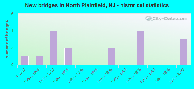
- New bridges - historical statistics
- 1Before 1900
- 11900-1909
- 41910-1919
- 21920-1929
- 21950-1959
- 41970-1979
- 32000-2009

- Reconstructed bridges - Historical Statistics
- 11930-1939
- 01940-1949
- 11950-1959
- 01960-1969
- 11970-1979
- 01980-1989
- 11990-1999
- 32000-2009


- Bridge Condition - Deck
- 50.0%Good
- 33.3%Satisfactory
- 16.7%Fair

- Bridge Condition - Superstructure
- 20.0%Very good
- 20.0%Good
- 20.0%Satisfactory
- 40.0%Fair

- Bridge Condition - Substructure
- 53.3%Good
- 20.0%Satisfactory
- 26.7%Fair

- Bridge Condition - Channel
- 20.0%Good
- 60.0%Satisfactory
- 20.0%Fair
Find on map >> Show street view
Structure Number: 180315, Location: 0.62 MI E OF JCT I-287 (Lat: 40.574731, Lng: -74.555539), Route carried "on" structure: US 22, Year Built: 1929, Year Reconstructed: 2014, Status: Open, Structure Length: 2.04m (6.69ft), Average Daily Traffic: 59,700 (year 2021), Truck Traffic: 4%, Average Future Daily Traffic: 71,700 (year 2041), Design Load: HS 25 or greater, Features Intersected: MIDDLE BROOK
Minimum Vertical Clearance: 30+ m (98+ ft), Kilometerpoint: 60.270, Lanes on structure: 6, Base Highway Network: Yes, Owner: State Highway Agency, Approaching Roadway Width: 33.2m (108.9ft), Skew: 30 degrees, Material/Design: Steel, Design/Construction: Stringer/Multi-beam, Number Of Spans In Main Unit: 1, Length of Maximum Span: 19.5m (64.0ft), Curb or Sidewalk Widths: Left: 2.3m (7.5ft), Right: 2.9m (9.5ft), Curb-To-Curb Width: 33.2m (108.9ft), Out-to-Out Width: 42.9m (140.7ft)
Condition: Deck: Satisfactory, Superstructure: Satisfactory, Substructure: Satisfactory, Channel: Fair, Operating Rating: 62.6 metric tons, Method Used To Determine Operating Rating: Load Factor (LF), Inventory Rating: 37.2 metric tons, Method Used To Determine Inventory Rating: Load Factor (LF), Structural Evaluation: Equal to present minimum criteria, Deck Geometry: Superior to present desirable criteria, Waterway Adequacy: Superior to present desirable criteria, Approach Roadway Alignment: Equal to present desirable criteria, Designated Inspection Frequency: Every 24 months, Inspection Date: August 2021, Deck Structure Type: Concrete Cast-file-Place, Wearing Surface/Protective System: Wearing Surface: Bituminous, Membrane: Other
Find on map >> Show street view
Structure Number: 1803156, Location: 8MI EAST OF I-287 JCT (Lat: 40.625761, Lng: -74.439619), Route carried "on" structure: US 22, Year Built: 1929, Year Reconstructed: 1937, Status: Open, Structure Length: 1.37m (4.49ft), Average Daily Traffic: 70,150 (year 2021), Truck Traffic: 4%, Average Future Daily Traffic: 85,597 (year 2041), Design Load: H 20, Features Intersected: STONY BROOK
Minimum Vertical Clearance: 30+ m (98+ ft), Kilometerpoint: 71.777, Lanes on structure: 6, Base Highway Network: Yes, Owner: State Highway Agency, Approaching Roadway Width: 23.2m (76.1ft), Skew: 31 degrees, Material/Design: Steel, Design/Construction: Stringer/Multi-beam, Number Of Spans In Main Unit: 1, Length of Maximum Span: 12.8m (42.0ft), Curb or Sidewalk Widths: Left: 1.8m (5.9ft), Right: 1.8m (5.9ft), Curb-To-Curb Width: 23.2m (76.1ft), Out-to-Out Width: 28.2m (92.5ft)
Condition: Deck: Satisfactory, Superstructure: Fair, Substructure: Fair, Channel: Satisfactory, Operating Rating: 41.7 metric tons, Method Used To Determine Operating Rating: Load Factor (LF), Inventory Rating: 25.4 metric tons, Method Used To Determine Inventory Rating: Load Factor (LF), Structural Evaluation: Somewhat better than minimum adequacy, Deck Geometry: Meets minimum limits, Waterway Adequacy: Somewhat better than minimum adequacy, Approach Roadway Alignment: Equal to present desirable criteria, Length Of Structure Improvement: 1.37m (4.49ft), Designated Inspection Frequency: Every 24 months, Inspection Date: June 2021, Bridge Improvement Cost: $290,000, Total Project Cost: $290,000 ( Estimate for 2021), Deck Structure Type: Concrete Cast-file-Place, Wearing Surface/Protective System: Wearing Surface: Bituminous
Find on map >> Show street view
Structure Number: 1803158, Location: 8.93 MI SOUTH OF I-287 (Lat: 40.627500, Lng: -74.436531), Route carried "on" structure: County highway 531, Year Built: 1956, Status: Open, Structure Length: 3.60m (11.81ft), Average Daily Traffic: 11,811 (year 2018), Truck Traffic: 4%, Average Future Daily Traffic: 14,411 (year 2039), Design Load: HS 20, Features Intersected: U.S. 22, Facility Carried by Structure: WATCHUNG AVE
Minimum Vertical Clearance: 30+ m (98+ ft), Kilometerpoint: 15.723, Lanes on structure: 4, Lanes under structure: 6, Owner: State Highway Agency, Approaching Roadway Width: 14.6m (47.9ft), Skew: 21 degrees, Material/Design: Steel, Design/Construction: Stringer/Multi-beam, Number Of Spans In Main Unit: 2, Length of Maximum Span: 16.5m (54.1ft), Curb or Sidewalk Widths: Left: 1.8m (5.9ft), Right: 1.8m (5.9ft), Curb-To-Curb Width: 14.6m (47.9ft), Out-to-Out Width: 19.5m (64.0ft)
Condition: Deck: Satisfactory, Superstructure: Fair, Substructure: Fair, Operating Rating: 77.1 metric tons, Method Used To Determine Operating Rating: Load Factor (LF), Inventory Rating: 46.3 metric tons, Method Used To Determine Inventory Rating: Load Factor (LF), Structural Evaluation: Somewhat better than minimum adequacy, Deck Geometry: High priority of replacement, Underclear: Somewhat better than minimum adequacy, Approach Roadway Alignment: Better than present minimum criteria, Length Of Structure Improvement: 3.60m (11.81ft), Designated Inspection Frequency: Every 24 months, Inspection Date: August 2021, Bridge Improvement Cost: $121,000, Roadway Improvement Cost: $13,000, Total Project Cost: $191,000 ( Estimate for 2019), Deck Structure Type: Concrete Cast-file-Place, Wearing Surface/Protective System: Wearing Surface: Bituminous
Find on map >> Show street view
Structure Number: 18M0901, Location: 0.38 MI S. OF CR 636 (Lat: 40.605331, Lng: -74.449611), Route carried "on" structure: City street , Year Built: 2004, Status: Open, Structure Length: 2.90m (9.51ft), Average Daily Traffic: 9,168 (year 2021), Truck Traffic: 3%, Average Future Daily Traffic: 11,186 (year 2041), Design Load: HS 20+Mod, Features Intersected: GREEN BROOK, Facility Carried by Structure: CLINTON AVE
Minimum Vertical Clearance: 30+ m (98+ ft), Kilometerpoint: 0.000, Lanes on structure: 2, Owner: County Highway Agency, Approaching Roadway Width: 12.2m (40.0ft), Skew: 2 degrees, Material/Design: Steel continuous, Design/Construction: Stringer/Multi-beam, Number Of Spans In Main Unit: 2, Length of Maximum Span: 14.0m (45.9ft), Curb or Sidewalk Widths: Left: 1.8m (5.9ft), Right: 1.8m (5.9ft), Curb-To-Curb Width: 12.2m (40.0ft), Out-to-Out Width: 16.6m (54.5ft)
Condition: Deck: Good, Superstructure: Very good, Substructure: Good, Channel: Satisfactory, Inventory Rating: 59.0 metric tons, Method Used To Determine Inventory Rating: Load Factor (LF), Structural Evaluation: Better than present minimum criteria, Deck Geometry: Somewhat better than minimum adequacy, Waterway Adequacy: Equal to present minimum criteria, Approach Roadway Alignment: Equal to present desirable criteria, Designated Inspection Frequency: Every 24 months, Inspection Date: October 2021, Deck Structure Type: Concrete Cast-file-Place, Wearing Surface/Protective System: Wearing Surface: Monolithic Concrete, Deck Protection: Galvanized Reinforcing
Find on map >> Show street view
Structure Number: 18M0902, Location: 0.95 MI S OF US 22 (Lat: 40.610211, Lng: -74.437381), Route carried "on" structure: County highway 649, Year Built: 2003, Status: Open, Structure Length: 2.01m (6.59ft), Average Daily Traffic: 10,046 (year 2021), Truck Traffic: 3%, Average Future Daily Traffic: 12,258 (year 2041), Design Load: HS 20+Mod, Features Intersected: GREEN BROOK, Facility Carried by Structure: WEST END AVE
Minimum Vertical Clearance: 30+ m (98+ ft), Kilometerpoint: 0.000, Lanes on structure: 2, Owner: County Highway Agency, Approaching Roadway Width: 13.4m (44.0ft), Material/Design: Concrete, Design/Construction: Arch - Deck, Number Of Spans In Main Unit: 2, Length of Maximum Span: 9.8m (32.2ft), Curb or Sidewalk Widths: Left: 3.4m (11.2ft), Right: 2.7m (8.9ft), Curb-To-Curb Width: 13.4m (44.0ft), Out-to-Out Width: 20.3m (66.6ft)
Condition: Superstructure: Good, Substructure: Good, Channel: Good, Inventory Rating: 63.5 metric tons, Method Used To Determine Inventory Rating: Load Factor (LF), Structural Evaluation: Better than present minimum criteria, Deck Geometry: Equal to present minimum criteria, Waterway Adequacy: Equal to present minimum criteria, Approach Roadway Alignment: Equal to present desirable criteria, Designated Inspection Frequency: Every 24 months, Inspection Date: October 2021
Find on map >> Show street view
Structure Number: 18M0904, Location: 0.1 MI W. OF NJ ROUTE 28 (Lat: 40.615139, Lng: -74.431569), Route carried "on" structure: City street , Year Built: 1910, Year Reconstructed: 2011, Status: Open, Structure Length: 1.49m (4.89ft), Average Daily Traffic: 556 (year 2021), Truck Traffic: 1%, Average Future Daily Traffic: 667 (year 2023), Design Load: HS 25 or greater, Features Intersected: GREEN BROOK, Facility Carried by Structure: SYCAMORE AVENUE
Minimum Vertical Clearance: 30+ m (98+ ft), Kilometerpoint: 0.000, Lanes on structure: 2, Owner: County Highway Agency, Approaching Roadway Width: 10.5m (34.4ft), Material/Design: Steel, Design/Construction: Stringer/Multi-beam, Number Of Spans In Main Unit: 1, Length of Maximum Span: 14.3m (46.9ft), Curb or Sidewalk Widths: Left: 3.4m (11.2ft), Right: 3.4m (11.2ft), Curb-To-Curb Width: 10.5m (34.4ft), Out-to-Out Width: 18.1m (59.4ft)
Condition: Deck: Good, Superstructure: Fair, Substructure: Satisfactory, Channel: Satisfactory, Operating Rating: 64.4 metric tons, Method Used To Determine Operating Rating: Load Factor (LF), Inventory Rating: 39.0 metric tons, Method Used To Determine Inventory Rating: Load Factor (LF), Structural Evaluation: Somewhat better than minimum adequacy, Deck Geometry: Equal to present minimum criteria, Waterway Adequacy: Equal to present minimum criteria, Approach Roadway Alignment: Equal to present desirable criteria, Designated Inspection Frequency: Every 24 months, Inspection Date: October 2021, Deck Structure Type: Concrete Cast-file-Place, Wearing Surface/Protective System: Wearing Surface: Monolithic Concrete, Deck Protection: Galvanized Reinforcing
Find on map >> Show street view
Structure Number: 18M0905, Location: 0.07 MI N. OF NJ 28 (Lat: 40.616250, Lng: -74.429181), Route carried "on" structure: City street , Year Built: 1911, Status: Open, Structure Length: 1.52m (4.99ft), Average Daily Traffic: 1,742 (year 2021), Truck Traffic: 1%, Average Future Daily Traffic: 2,091 (year 2041), Design Load: H 20, Features Intersected: GREEN BROOK, Facility Carried by Structure: WASHINGTON AVENUE
Minimum Vertical Clearance: 30+ m (98+ ft), Kilometerpoint: 0.000, Lanes on structure: 2, Owner: County Highway Agency, Approaching Roadway Width: 9.1m (29.9ft), Material/Design: Concrete, Design/Construction: Arch - Deck, Number Of Spans In Main Unit: 1, Length of Maximum Span: 15.2m (49.9ft), Curb or Sidewalk Widths: Left: 2.8m (9.2ft), Right: 2.8m (9.2ft), Curb-To-Curb Width: 9.1m (29.9ft), Out-to-Out Width: 15.4m (50.5ft)
Condition: Superstructure: Fair, Substructure: Good, Channel: Satisfactory, Operating Rating: 34.5 metric tons, Method Used To Determine Operating Rating: Field evaluation and documented engineering judgment, Inventory Rating: 20.9 metric tons, Method Used To Determine Inventory Rating: Field evaluation and documented engineering judgment, Structural Evaluation: Somewhat better than minimum adequacy, Deck Geometry: Somewhat better than minimum adequacy, Waterway Adequacy: Equal to present minimum criteria, Approach Roadway Alignment: Equal to present desirable criteria, Designated Inspection Frequency: Every 24 months, Inspection Date: September 2021
Find on map >> Show street view
Structure Number: 18M0906, Location: 250 ft N of W. front ST (Lat: 40.617139, Lng: -74.426950), Route carried "on" structure: City street , Year Built: 1916, Status: Open, Structure Length: 1.58m (5.18ft), Average Daily Traffic: 9,063 (year 2021), Truck Traffic: 1%, Average Future Daily Traffic: 11,058 (year 2041), Design Load: HS 20, Features Intersected: GREEN BROOK, Facility Carried by Structure: GROVE STREET
Minimum Vertical Clearance: 30+ m (98+ ft), Kilometerpoint: 0.000, Lanes on structure: 2, Owner: County Highway Agency, Approaching Roadway Width: 11.0m (36.1ft), Material/Design: Concrete, Design/Construction: Arch - Deck, Number Of Spans In Main Unit: 1, Length of Maximum Span: 15.8m (51.8ft), Curb or Sidewalk Widths: Left: 2.9m (9.5ft), Right: 2.9m (9.5ft), Curb-To-Curb Width: 11.0m (36.1ft), Out-to-Out Width: 18.2m (59.7ft)
Condition: Superstructure: Fair, Substructure: Fair, Channel: Satisfactory, Operating Rating: 54.4 metric tons, Method Used To Determine Operating Rating: Field evaluation and documented engineering judgment, Inventory Rating: 32.7 metric tons, Method Used To Determine Inventory Rating: Field evaluation and documented engineering judgment, Structural Evaluation: Somewhat better than minimum adequacy, Deck Geometry: Meets minimum limits, Waterway Adequacy: Better than present minimum criteria, Approach Roadway Alignment: Equal to present minimum criteria, Designated Inspection Frequency: Every 24 months, Inspection Date: October 2021
Find on map >> Show street view
Structure Number: 18M0907, Location: 0.4 mi S of US 22 (Lat: 40.614119, Lng: -74.446011), Route carried "on" structure: County highway 649, Year Built: 1976, Status: Open, Structure Length: 1.92m (6.30ft), Average Daily Traffic: 10,046 (year 2021), Truck Traffic: 3%, Average Future Daily Traffic: 12,258 (year 2041), Design Load: HS 20, Features Intersected: STONY BROOK, Facility Carried by Structure: WEST END AVE
Minimum Vertical Clearance: 30+ m (98+ ft), Kilometerpoint: 0.885, Lanes on structure: 2, Owner: County Highway Agency, Approaching Roadway Width: 12.2m (40.0ft), Skew: 2 degrees, Material/Design: Prestressed concrete, Design/Construction: Box Beam or Girders - Multiple, Number Of Spans In Main Unit: 1, Length of Maximum Span: 18.3m (60.0ft), Curb or Sidewalk Widths: Left: 1.5m (4.9ft), Right: 2.0m (6.6ft), Curb-To-Curb Width: 14.6m (47.9ft), Out-to-Out Width: 18.9m (62.0ft)
Condition: Deck: Good, Superstructure: Good, Substructure: Good, Channel: Satisfactory, Operating Rating: 49.0 metric tons, Method Used To Determine Operating Rating: Load Factor (LF), Inventory Rating: 29.0 metric tons, Method Used To Determine Inventory Rating: Load Factor (LF), Structural Evaluation: Better than present minimum criteria, Deck Geometry: Superior to present desirable criteria, Waterway Adequacy: Superior to present desirable criteria, Approach Roadway Alignment: Equal to present desirable criteria, Length Of Structure Improvement: 1.89m (6.20ft), Designated Inspection Frequency: Every 24 months, Inspection Date: October 2021, Bridge Improvement Cost: $440,000, Total Project Cost: $577,000 ( Estimate for 2019), Deck Structure Type: Concrete Cast-file-Place, Wearing Surface/Protective System: Wearing Surface: Latex Concrete
Find on map >> Show street view
Structure Number: 18M1001, Location: 0.29 MI N.OF NJ 28 (Lat: 40.617919, Lng: -74.426419), Route carried "on" structure: City street , Year Built: 1903, Year Reconstructed: 2007, Status: Open, Structure Length: 1.52m (4.99ft), Average Daily Traffic: 2,427 (year 2021), Truck Traffic: 1%, Average Future Daily Traffic: 2,961 (year 2041), Design Load: HS 20+Mod, Features Intersected: GREEN BROOK, Facility Carried by Structure: DUER STREET
Minimum Vertical Clearance: 30+ m (98+ ft), Kilometerpoint: 0.000, Lanes on structure: 2, Owner: County Highway Agency, Approaching Roadway Width: 9.1m (29.9ft), Skew: 1 degrees, Material/Design: Steel, Design/Construction: Stringer/Multi-beam, Number Of Spans In Main Unit: 1, Length of Maximum Span: 14.6m (47.9ft), Curb or Sidewalk Widths: Left: 2.5m (8.2ft), Right: 2.5m (8.2ft), Curb-To-Curb Width: 9.1m (29.9ft), Out-to-Out Width: 15.1m (49.5ft)
Condition: Deck: Good, Superstructure: Very good, Substructure: Good, Channel: Satisfactory, Inventory Rating: 84.4 metric tons, Method Used To Determine Inventory Rating: Load Factor (LF), Structural Evaluation: Better than present minimum criteria, Deck Geometry: Meets minimum limits, Waterway Adequacy: Better than present minimum criteria, Approach Roadway Alignment: Equal to present desirable criteria, Designated Inspection Frequency: Every 24 months, Inspection Date: September 2021, Deck Structure Type: Concrete Cast-file-Place, Wearing Surface/Protective System: Wearing Surface: Monolithic Concrete, Deck Protection: Galvanized Reinforcing
Find on map >> Show street view
Structure Number: 18M1002, Location: 1.04 mi S of US 22 (Lat: 40.619069, Lng: -74.424931), Route carried "on" structure: County highway 531, Year Built: 1889, Year Reconstructed: 1963, Status: Open, Structure Length: 1.58m (5.18ft), Average Daily Traffic: 9,008 (year 2021), Truck Traffic: 4%, Average Future Daily Traffic: 10,992 (year 2041), Design Load: HS 20, Features Intersected: GREEN BROOK, Facility Carried by Structure: SOMERSET STREET
Minimum Vertical Clearance: 30+ m (98+ ft), Kilometerpoint: 14.098, Lanes on structure: 2, Owner: County Highway Agency, Approaching Roadway Width: 11.3m (37.1ft), Skew: 1 degrees, Material/Design: Prestressed concrete, Design/Construction: Box Beam or Girders - Multiple, Number Of Spans In Main Unit: 1, Length of Maximum Span: 14.9m (48.9ft), Curb or Sidewalk Widths: Left: 4.0m (13.1ft), Right: 4.3m (14.1ft), Curb-To-Curb Width: 11.3m (37.1ft), Out-to-Out Width: 19.5m (64.0ft)
Condition: Deck: Fair, Superstructure: Fair, Substructure: Fair, Channel: Good, Operating Rating: 33.6 metric tons, Method Used To Determine Operating Rating: Load and Resistance Factor (LRFR), Inventory Rating: 20.0 metric tons, Method Used To Determine Inventory Rating: Load Factor (LF), Structural Evaluation: Somewhat better than minimum adequacy, Deck Geometry: Meets minimum limits, Waterway Adequacy: Superior to present desirable criteria, Approach Roadway Alignment: Equal to present desirable criteria, Designated Inspection Frequency: Every 24 months, Inspection Date: October 2021, Deck Structure Type: Concrete Precast Panels, Wearing Surface/Protective System: Wearing Surface: Bituminous
Find on map >> Show street view
Structure Number: 18M1003, Location: .06 MI S OF GREENBROOK RD (Lat: 40.619869, Lng: -74.438600), Route carried "on" structure: City street , Year Built: 1913, Year Reconstructed: 2002, Status: Open, Structure Length: 1.71m (5.61ft), Average Daily Traffic: 2,456 (year 2021), Truck Traffic: 1%, Average Future Daily Traffic: 2,947 (year 2041), Design Load: HS 25 or greater, Features Intersected: Stony Brook, Facility Carried by Structure: Rockview Terrace
Minimum Vertical Clearance: 30+ m (98+ ft), Kilometerpoint: 0.000, Lanes on structure: 2, Owner: County Highway Agency, Approaching Roadway Width: 9.1m (29.9ft), Material/Design: Steel, Design/Construction: Stringer/Multi-beam, Number Of Spans In Main Unit: 1, Length of Maximum Span: 15.8m (51.8ft), Curb or Sidewalk Widths: Left: 2.7m (8.9ft), Right: 2.7m (8.9ft), Curb-To-Curb Width: 9.1m (29.9ft), Out-to-Out Width: 15.2m (49.9ft)
Condition: Deck: Good, Superstructure: Satisfactory, Substructure: Good, Channel: Fair, Operating Rating: 88.9 metric tons, Method Used To Determine Operating Rating: Load Factor (LF), Inventory Rating: 52.6 metric tons, Method Used To Determine Inventory Rating: Load Factor (LF), Structural Evaluation: Equal to present minimum criteria, Deck Geometry: Meets minimum limits, Waterway Adequacy: Equal to present minimum criteria, Approach Roadway Alignment: Equal to present desirable criteria, Designated Inspection Frequency: Every 24 months, Inspection Date: September 2021, Deck Structure Type: Concrete Cast-file-Place, Wearing Surface/Protective System: Wearing Surface: Monolithic Concrete, Deck Protection: Galvanized Reinforcing
Find on map >> Show street view
Structure Number: 18M1004, Location: 0.2 mi W of CR 531S (Lat: 40.622089, Lng: -74.436111), Route carried "on" structure: County highway 636, Year Built: 1973, Year Reconstructed: 1979, Status: Open, Structure Length: 1.55m (5.09ft), Average Daily Traffic: 8,813 (year 2021), Truck Traffic: 4%, Average Future Daily Traffic: 10,754 (year 2041), Design Load: HS 20, Features Intersected: STONY BROOK, Facility Carried by Structure: GREEN BROOK RD
Minimum Vertical Clearance: 30+ m (98+ ft), Kilometerpoint: 2.849, Lanes on structure: 2, Owner: County Highway Agency, Approaching Roadway Width: 11.3m (37.1ft), Skew: 1 degrees, Material/Design: Prestressed concrete, Design/Construction: Box Beam or Girders - Multiple, Number Of Spans In Main Unit: 1, Length of Maximum Span: 14.6m (47.9ft), Curb or Sidewalk Widths: Left: 1.8m (5.9ft), Right: 1.8m (5.9ft), Curb-To-Curb Width: 10.4m (34.1ft), Out-to-Out Width: 14.7m (48.2ft)
Condition: Deck: Satisfactory, Superstructure: Good, Substructure: Good, Channel: Satisfactory, Operating Rating: 40.8 metric tons, Method Used To Determine Operating Rating: Load Factor (LF), Inventory Rating: 16.3 metric tons, Method Used To Determine Inventory Rating: Load Factor (LF), Structural Evaluation: Meets minimum limits, Deck Geometry: Meets minimum limits, Waterway Adequacy: Better than present minimum criteria, Approach Roadway Alignment: Equal to present desirable criteria, Designated Inspection Frequency: Every 24 months, Inspection Date: October 2021, Deck Structure Type: Concrete Cast-file-Place, Wearing Surface/Protective System: Wearing Surface: Latex Concrete
Find on map >> Show street view
Structure Number: 18M1005, Location: 0.05 mi N of CR 636 (Lat: 40.622889, Lng: -74.436319), Route carried "on" structure: City street , Year Built: 1977, Status: Open, Structure Length: 0.67m (2.20ft), Average Daily Traffic: 5,248 (year 2021), Truck Traffic: 1%, Average Future Daily Traffic: 6,404 (year 2041), Design Load: HS 20+Mod, Features Intersected: CRAB BROOK, Facility Carried by Structure: GROVE STREET
Minimum Vertical Clearance: 30+ m (98+ ft), Kilometerpoint: 0.000, Lanes on structure: 2, Owner: County Highway Agency, Approaching Roadway Width: 11.0m (36.1ft), Skew: 1 degrees, Material/Design: Concrete, Design/Construction: Culvert, Number Of Spans In Main Unit: 1, Length of Maximum Span: 6.7m (22.0ft), Curb or Sidewalk Widths: Left: 2.7m (8.9ft), Right: 2.7m (8.9ft), Curb-To-Curb Width: 11.0m (36.1ft), Out-to-Out Width: 17.2m (56.4ft)
Condition: Channel: Good, Culverts: Satisfactory, Operating Rating: 47.2 metric tons, Method Used To Determine Operating Rating: Load Factor (LF), Inventory Rating: 28.1 metric tons, Method Used To Determine Inventory Rating: Load Factor (LF), Structural Evaluation: Equal to present minimum criteria, Deck Geometry: Meets minimum limits, Waterway Adequacy: Equal to present desirable criteria, Approach Roadway Alignment: Equal to present desirable criteria, Designated Inspection Frequency: Every 24 months, Inspection Date: October 2021, Deck Structure Type: Concrete Cast-file-Place, Wearing Surface/Protective System: Wearing Surface: Integral Concrete
Find on map >> Show street view
Structure Number: 18M1006, Location: 0.08 MI SO US 22 (Lat: 40.624700, Lng: -74.439261), Route carried "on" structure: City street , Year Built: 2005, Status: Open, Structure Length: 1.92m (6.30ft), Average Daily Traffic: 1,122 (year 2021), Truck Traffic: 1%, Average Future Daily Traffic: 1,345 (year 2041), Design Load: HS 25 or greater, Features Intersected: STONY BROOK, Facility Carried by Structure: GROVE STREET
Minimum Vertical Clearance: 30+ m (98+ ft), Kilometerpoint: 0.000, Lanes on structure: 2, Owner: County Highway Agency, Approaching Roadway Width: 11.0m (36.1ft), Skew: 2 degrees, Material/Design: Steel, Design/Construction: Stringer/Multi-beam, Number Of Spans In Main Unit: 1, Length of Maximum Span: 17.7m (58.1ft), Curb or Sidewalk Widths: Left: 2.4m (7.9ft), Right: 1.8m (5.9ft), Curb-To-Curb Width: 11.0m (36.1ft), Out-to-Out Width: 15.8m (51.8ft)
Condition: Deck: Good, Superstructure: Very good, Substructure: Satisfactory, Channel: Fair, Inventory Rating: 70.8 metric tons, Method Used To Determine Inventory Rating: Load Factor (LF), Structural Evaluation: Equal to present minimum criteria, Deck Geometry: Equal to present minimum criteria, Waterway Adequacy: Somewhat better than minimum adequacy, Approach Roadway Alignment: Equal to present desirable criteria, Designated Inspection Frequency: Every 24 months, Inspection Date: October 2021, Deck Structure Type: Concrete Cast-file-Place, Wearing Surface/Protective System: Wearing Surface: Monolithic Concrete, Deck Protection: Galvanized Reinforcing
Find on map >> Show street view
Structure Number: 18M1022, Location: AT SOMERSET ST INTERSECT. (Lat: 40.629050, Lng: -74.441861), Route carried "on" structure: City street , Year Built: 1976, Status: Open, Structure Length: 1.86m (6.10ft), Average Daily Traffic: 1,887 (year 2021), Truck Traffic: 1%, Average Future Daily Traffic: 2,303 (year 2041), Design Load: HS 20+Mod, Features Intersected: STONY BROOK, Facility Carried by Structure: INTERHAVEN AVENUE
Minimum Vertical Clearance: 30+ m (98+ ft), Kilometerpoint: 0.000, Lanes on structure: 2, Owner: County Highway Agency, Approaching Roadway Width: 9.1m (29.9ft), Skew: 2 degrees, Material/Design: Prestressed concrete, Design/Construction: Box Beam or Girders - Multiple, Number Of Spans In Main Unit: 1, Length of Maximum Span: 17.7m (58.1ft), Curb or Sidewalk Widths: Left: 0.4m (1.3ft), Right: 1.5m (4.9ft), Curb-To-Curb Width: 9.1m (29.9ft), Out-to-Out Width: 11.8m (38.7ft)
Condition: Deck: Fair, Superstructure: Satisfactory, Substructure: Good, Channel: Satisfactory, Operating Rating: 56.2 metric tons, Method Used To Determine Operating Rating: Load Factor (LF), Inventory Rating: 33.6 metric tons, Method Used To Determine Inventory Rating: Load Factor (LF), Structural Evaluation: Equal to present minimum criteria, Deck Geometry: Somewhat better than minimum adequacy, Waterway Adequacy: Equal to present desirable criteria, Approach Roadway Alignment: Better than present minimum criteria, Designated Inspection Frequency: Every 24 months, Inspection Date: September 2021, Deck Structure Type: Concrete Cast-file-Place, Wearing Surface/Protective System: Wearing Surface: Bituminous, Membrane: Preformed Fabric
Find on map >> Show street view
Structure Number: 1803158, Location: 8.93 MI SOUTH OF I-287 (Lat: 40.627500, Lng: -74.436531), Route carried "under" structure: US 22, Year Built: 1956, Structure Length: 0. m, Average Daily Traffic: 69,735 (year 2019), Truck Traffic: 4%, Features Intersected: U.S. 22, Facility Carried by Structure: WATCHUNG AVE
Minimum Vertical Clearance: 4.80m (15.75ft), Kilometerpoint: 72.211, Lanes on structure: 4, Lanes under structure: 6, Material/Design: Steel, Design/Construction: Stringer/Multi-beam, Length of Maximum Span: 16.5m (54.1ft)