Bridge Statistics for North Sioux City, South Dakota (SD)
Condition, Traffic, Stress, Structural Evaluation, Project Costs
- National Bridge Inventory (NBI) Statistics
- 10Number of bridges
- 92ft / 27.8mTotal length
- $2,000,000Total costs
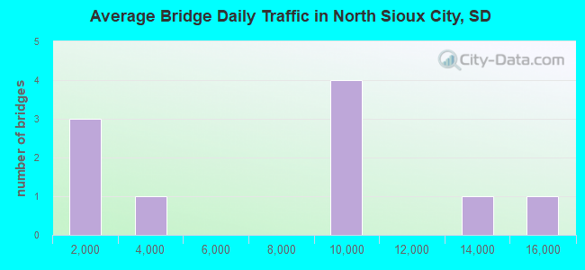
- 71,316Total average daily traffic
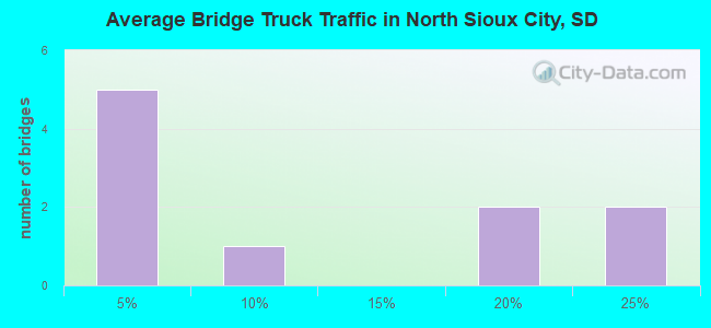
- 10,334Total average daily truck traffic
- National Bridge Inventory (NBI) Registered Bridges for North Sioux City
- No street view available for this location
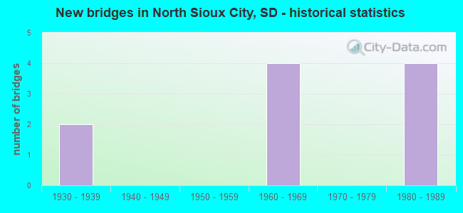
- New bridges - historical statistics
- 21930-1939
- 41960-1969
- 41980-1989
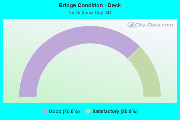
- Bridge Condition - Deck
- 75.0%Good
- 25.0%Satisfactory
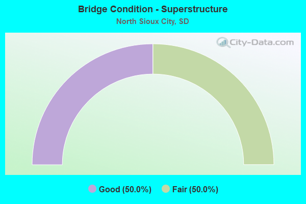
- Bridge Condition - Superstructure
- 50.0%Good
- 50.0%Fair
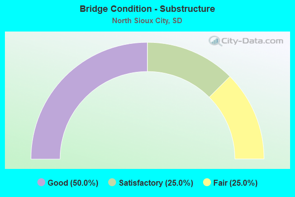
- Bridge Condition - Substructure
- 50.0%Good
- 25.0%Satisfactory
- 25.0%Fair
Find on map >> Show street view
Structure Number: 64140355, Location: 3.4 NW N SCITY INTERCH (Lat: 42.568497, Lng: -96.526594), Route carried "on" structure: County highway , Year Built: 1961, Status: Open, Structure Length: 11.13m (36.52ft), Average Daily Traffic: 240 (year 2020), Truck Traffic: 5%, Average Future Daily Traffic: 240 (year 2040), Design Load: HS 20, Features Intersected: I029, Facility Carried by Structure: 484 AVE
Minimum Vertical Clearance: 30+ m (98+ ft), Kilometerpoint: 0.000, Lanes on structure: 2, Lanes under structure: 4, Owner: State Highway Agency, Approaching Roadway Width: 9.1m (29.9ft), Material/Design: Concrete continuous, Design/Construction: Box Beam or Girders - Multiple, Number Of Spans In Main Unit: 4, Length of Maximum Span: 30.5m (100.1ft), Curb-To-Curb Width: 9.1m (29.9ft), Out-to-Out Width: 10.5m (34.4ft)
Condition: Deck: Good, Superstructure: Fair, Substructure: Fair, Operating Rating: 39.0 metric tons, Method Used To Determine Operating Rating: Load Factor (LF), Inventory Rating: 23.0 metric tons, Method Used To Determine Inventory Rating: Load Factor (LF), Structural Evaluation: Somewhat better than minimum adequacy, Deck Geometry: Equal to present minimum criteria, Underclear: Meets minimum limits, Approach Roadway Alignment: Equal to present minimum criteria, Designated Inspection Frequency: Every 24 months, Inspection Date: October 2021, Deck Structure Type: Concrete Cast-file-Place, Wearing Surface/Protective System: Wearing Surface: Epoxy Overlay, Membrane: Epoxy
Find on map >> Show street view
Structure Number: 64149367, Location: 1.9 N of N SIOUX CITY INT (Lat: 42.550200, Lng: -96.508281), Route carried "on" structure: Spur Interstate 29, Year Built: 1961, Status: Open, Structure Length: 8.94m (29.33ft), Average Daily Traffic: 3,210 (year 2021), Truck Traffic: 3%, Average Future Daily Traffic: 4,898 (year 2041), Design Load: HS 20, Features Intersected: I029
Minimum Vertical Clearance: 30+ m (98+ ft), Kilometerpoint: 7.081, Lanes on structure: 2, Lanes under structure: 4, Owner: State Highway Agency, Approaching Roadway Width: 9.1m (29.9ft), Material/Design: Concrete continuous, Design/Construction: Box Beam or Girders - Multiple, Number Of Spans In Main Unit: 4, Length of Maximum Span: 24.4m (80.1ft), Curb-To-Curb Width: 9.1m (29.9ft), Out-to-Out Width: 10.5m (34.4ft)
Condition: Deck: Satisfactory, Superstructure: Fair, Substructure: Satisfactory, Operating Rating: 60.1 metric tons, Method Used To Determine Operating Rating: Load Factor (LF), Inventory Rating: 35.9 metric tons, Method Used To Determine Inventory Rating: Load Factor (LF), Structural Evaluation: Somewhat better than minimum adequacy, Deck Geometry: Meets minimum limits, Underclear: Somewhat better than minimum adequacy, Approach Roadway Alignment: Equal to present minimum criteria, Length Of Structure Improvement: 6.10m (20.01ft), Designated Inspection Frequency: Every 24 months, Inspection Date: August 2021, Bridge Improvement Cost: $1,200,000, Roadway Improvement Cost: $500,000, Total Project Cost: $2,000,000, Deck Structure Type: Concrete Cast-file-Place, Wearing Surface/Protective System: Wearing Surface: Low Slump Concrete
Find on map >> Show street view
Structure Number: 64154385, Location: N SIOUX CITY INTERCHANGE (Lat: 42.524850, Lng: -96.499597), Route carried "on" structure: Interstate 29, Year Built: 1981, Status: Open, Structure Length: 3.84m (12.60ft), Average Daily Traffic: 9,580 (year 2021), Truck Traffic: 18%, Average Future Daily Traffic: 13,479 (year 2041), Design Load: HS 20+Mod, Features Intersected: RIVER DRIVE
Minimum Vertical Clearance: 30+ m (98+ ft), Kilometerpoint: 3.991, Lanes on structure: 2, Lanes under structure: 2, Base Highway Network: Yes, Owner: State Highway Agency, Approaching Roadway Width: 12.2m (40.0ft), Material/Design: Concrete continuous, Design/Construction: Slab, Number Of Spans In Main Unit: 3, Length of Maximum Span: 15.6m (51.2ft), Curb-To-Curb Width: 12.2m (40.0ft), Out-to-Out Width: 13.0m (42.7ft)
Condition: Deck: Good, Superstructure: Good, Substructure: Good, Operating Rating: 69.5 metric tons, Method Used To Determine Operating Rating: Load Factor (LF), Inventory Rating: 41.6 metric tons, Method Used To Determine Inventory Rating: Load Factor (LF), Structural Evaluation: Better than present minimum criteria, Deck Geometry: Better than present minimum criteria, Underclear: High priority of corrective action, Approach Roadway Alignment: Equal to present desirable criteria, Designated Inspection Frequency: Every 24 months, Inspection Date: April 2021, Deck Structure Type: Concrete Cast-file-Place, Wearing Surface/Protective System: Wearing Surface: Monolithic Concrete, Deck Protection: Epoxy Coated Reinforcing
Find on map >> Show street view
Structure Number: 64155385, Location: N SIOUX CITY INTERCHANGE (Lat: 42.524850, Lng: -96.499275), Route carried "on" structure: Interstate 29, Year Built: 1981, Status: Open, Structure Length: 3.84m (12.60ft), Average Daily Traffic: 9,580 (year 2021), Truck Traffic: 18%, Average Future Daily Traffic: 13,479 (year 2041), Design Load: HS 20+Mod, Features Intersected: RIVER DRIVE
Minimum Vertical Clearance: 30+ m (98+ ft), Kilometerpoint: 3.991, Lanes on structure: 2, Lanes under structure: 2, Base Highway Network: Yes, Owner: State Highway Agency, Approaching Roadway Width: 12.2m (40.0ft), Material/Design: Concrete continuous, Design/Construction: Slab, Number Of Spans In Main Unit: 3, Length of Maximum Span: 15.6m (51.2ft), Curb-To-Curb Width: 12.2m (40.0ft), Out-to-Out Width: 13.0m (42.7ft)
Condition: Deck: Good, Superstructure: Good, Substructure: Good, Operating Rating: 69.9 metric tons, Method Used To Determine Operating Rating: Load Factor (LF), Inventory Rating: 41.8 metric tons, Method Used To Determine Inventory Rating: Load Factor (LF), Structural Evaluation: Better than present minimum criteria, Deck Geometry: Better than present minimum criteria, Underclear: High priority of corrective action, Approach Roadway Alignment: Equal to present desirable criteria, Designated Inspection Frequency: Every 24 months, Inspection Date: April 2021, Deck Structure Type: Concrete Cast-file-Place, Wearing Surface/Protective System: Wearing Surface: Low Slump Concrete, Deck Protection: Epoxy Coated Reinforcing
Find on map >> Show street view
Structure Number: 64140355, Location: 3.4 NW N SCITY INTERCH (Lat: 42.568497, Lng: -96.526594), Route carried "under" structure: Interstate 29, Year Built: 1961, Structure Length: 0. m, Average Daily Traffic: 13,030 (year 2020), Truck Traffic: 23%, Features Intersected: I029, Facility Carried by Structure: 484 AVE
Minimum Vertical Clearance: 5.18m (16.99ft), Kilometerpoint: 9.463, Lanes on structure: 2, Lanes under structure: 4, Material/Design: Concrete continuous, Design/Construction: Box Beam or Girders - Multiple, Length of Maximum Span: 30.5m (100.1ft)
Find on map >> Show street view
Structure Number: 64149367, Location: 1.9 N of N SIOUX CITY INT (Lat: 42.550200, Lng: -96.508281), Route carried "under" structure: Interstate 29, Year Built: 1961, Structure Length: 0. m, Average Daily Traffic: 14,730 (year 2020), Truck Traffic: 20%, Features Intersected: I029
Minimum Vertical Clearance: 5.05m (16.57ft), Kilometerpoint: 7.001, Lanes on structure: 2, Lanes under structure: 4, Material/Design: Concrete continuous, Design/Construction: Box Beam or Girders - Multiple, Length of Maximum Span: 24.4m (80.1ft)
Find on map >> Show street view
Structure Number: 64154385, Location: N SIOUX CITY INTERCHANGE (Lat: 42.524850, Lng: -96.499597), Route carried "under" structure: City street , Year Built: 1981, Structure Length: 0. m, Average Daily Traffic: 8,603 (year 2020), Truck Traffic: 4%, Features Intersected: RIVER DRIVE, Facility Carried by Structure: I029 S
Minimum Vertical Clearance: 5.08m (16.67ft), Kilometerpoint: 0.000, Lanes on structure: 2, Lanes under structure: 2, Material/Design: Concrete continuous, Design/Construction: Slab, Length of Maximum Span: 15.6m (51.2ft)
Find on map >> Show street view
Structure Number: 64155385, Location: N SIOUX CITY INTERCHANGE (Lat: 42.524850, Lng: -96.499275), Route carried "under" structure: City street , Year Built: 1981, Structure Length: 0. m, Average Daily Traffic: 8,603 (year 2020), Truck Traffic: 4%, Features Intersected: RIVER DRIVE, Facility Carried by Structure: I029 N
Minimum Vertical Clearance: 5.05m (16.57ft), Kilometerpoint: 0.000, Lanes on structure: 2, Lanes under structure: 2, Material/Design: Concrete continuous, Design/Construction: Slab, Length of Maximum Span: 15.6m (51.2ft)
Find on map >> Show street view
Structure Number: 64163384, Location: NORTH SIOUX CITY (Lat: 42.528083, Lng: -96.482519), Route carried "under" structure: City street , Year Built: 1930, Structure Length: 0. m, Average Daily Traffic: 1,870 (year 2018), Truck Traffic: 4%, Features Intersected: CITY STREET, Facility Carried by Structure: SO DAK OWNED RR
Minimum Vertical Clearance: 4.04m (13.25ft), Kilometerpoint: 0.000, Lanes under structure: 2, Material/Design: Steel, Design/Construction: Stringer/Multi-beam, Length of Maximum Span: 9.8m (32.2ft)
Find on map >> Show street view
Structure Number: 64163385, Location: NORTH SIOUX CITY (Lat: 42.527986, Lng: -96.482606), Route carried "under" structure: City street , Year Built: 1930, Structure Length: 0. m, Average Daily Traffic: 1,870 (year 2018), Truck Traffic: 4%, Features Intersected: CITY STREET, Facility Carried by Structure: SO DAK OWNED RR
Minimum Vertical Clearance: 3.99m (13.09ft), Kilometerpoint: 0.000, Lanes under structure: 2, Material/Design: Steel, Design/Construction: Stringer/Multi-beam, Length of Maximum Span: 10.4m (34.1ft)