Bridge Statistics for Oakland, New Jersey (NJ)
Condition, Traffic, Stress, Structural Evaluation, Project Costs
- National Bridge Inventory (NBI) Statistics
- 18Number of bridges
- 200ft / 61.1mTotal length
- $790,000Total costs
- 578,371Total average daily traffic
- 48,763Total average daily truck traffic
- National Bridge Inventory (NBI) Registered Bridges for Oakland
- No street view available for this location
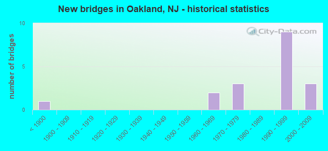
- New bridges - historical statistics
- 1Before 1900
- 21960-1969
- 31970-1979
- 91990-1999
- 32000-2009

- Reconstructed bridges - Historical Statistics
- 11980-1989
- 11990-1999
- 02000-2009
- 22010-2019


- Bridge Condition - Deck
- 33.3%Very good
- 33.3%Good
- 25.0%Satisfactory
- 8.3%Poor

- Bridge Condition - Superstructure
- 30.8%Very good
- 23.1%Good
- 30.8%Satisfactory
- 15.4%Fair

- Bridge Condition - Substructure
- 46.2%Good
- 53.8%Satisfactory

- Bridge Condition - Channel
- 8.3%Very good
- 66.7%Good
- 25.0%Satisfactory

- Bridge Condition - Culverts
- 50.0%Good
- 50.0%Satisfactory
Find on map >> Show street view
Structure Number: 20033A, Location: at intersect W US Rt 202 (Lat: 41.065569, Lng: -74.207850), Route carried "on" structure: Other road , Year Built: 1888, Year Reconstructed: 2010, Status: Posted for load, Structure Length: 3.23m (10.60ft), Average Daily Traffic: 475 (year 2020), Truck Traffic: 1%, Average Future Daily Traffic: 570 (year 2040), Features Intersected: RAMAPO RIVER, Facility Carried by Structure: BEAR SWAMP ROAD
Minimum Vertical Clearance: 30+ m (98+ ft), Kilometerpoint: 0.000, Lanes on structure: 1, Owner: County Highway Agency, Approaching Roadway Width: 3.7m (12.1ft), Material/Design: Steel, Design/Construction: Truss - Thru, Number Of Spans In Main Unit: 1, Length of Maximum Span: 30.5m (100.1ft), Curb-To-Curb Width: 3.7m (12.1ft), Out-to-Out Width: 4.8m (15.7ft)
Condition: Deck: Very good, Superstructure: Good, Substructure: Good, Channel: Satisfactory, Operating Rating: 55.3 metric tons, Method Used To Determine Operating Rating: Allowable Stress (AS), Inventory Rating: 37.2 metric tons, Method Used To Determine Inventory Rating: Allowable Stress (AS), Structural Evaluation: Better than present minimum criteria, Deck Geometry: High priority of replacement, Waterway Adequacy: High priority of replacement, Approach Roadway Alignment: Meets minimum limits, Length Of Structure Improvement: 3.32m (10.89ft), Designated Inspection Frequency: Every 24 months, Critical Feature Inspection Frequency: Every 24 months, Inspection Date: April 2020, Critical Feature Inspection Date: April 2020, Bridge Improvement Cost: $2,000, Total Project Cost: $3,000 ( Estimate for 2020), Deck Structure Type: Steel plate
Find on map >> Show street view
Structure Number: 20033G, Location: Camp Gaw Mtn. Resv. (Lat: 41.053381, Lng: -74.224531), Route carried "on" structure: City street , Year Built: 1996, Year Reconstructed: 2015, Status: Open, Structure Length: 3.44m (11.29ft), Average Daily Traffic: 421 (year 2020), Truck Traffic: 1%, Average Future Daily Traffic: 506 (year 2040), Design Load: HL 93, Features Intersected: RAMAPO RIVER, Facility Carried by Structure: GLEN GRAY ROAD
Minimum Vertical Clearance: 30+ m (98+ ft), Kilometerpoint: 0.000, Lanes on structure: 2, Owner: County Highway Agency, Approaching Roadway Width: 6.1m (20.0ft), Material/Design: Steel, Design/Construction: Truss - Thru, Number Of Spans In Main Unit: 1, Length of Maximum Span: 32.9m (107.9ft), Curb or Sidewalk Widths: Left: 0.0m, Right: 1.5m (4.9ft), Curb-To-Curb Width: 6.0m (19.7ft), Out-to-Out Width: 7.2m (23.6ft)
Condition: Deck: Very good, Superstructure: Very good, Substructure: Good, Channel: Good, Operating Rating: 78.9 metric tons, Method Used To Determine Operating Rating: Load Factor (LF), Inventory Rating: 47.2 metric tons, Method Used To Determine Inventory Rating: Load Factor (LF), Structural Evaluation: Better than present minimum criteria, Deck Geometry: High priority of replacement, Waterway Adequacy: Equal to present desirable criteria, Approach Roadway Alignment: Equal to present minimum criteria, Designated Inspection Frequency: Every 24 months, Critical Feature Inspection Frequency: Every 24 months, Inspection Date: April 2020, Critical Feature Inspection Date: April 2020, Deck Structure Type: Corrugated Steel, Wearing Surface/Protective System: Wearing Surface: Bituminous
Find on map >> Show street view
Structure Number: 20042A, Location: 0.061 MI. NORTH OF US 202 (Lat: 41.016500, Lng: -74.260669), Route carried "on" structure: City street , Year Built: 2003, Status: Open, Structure Length: 6.00m (19.69ft), Average Daily Traffic: 3,650 (year 2020), Truck Traffic: 3%, Average Future Daily Traffic: 4,370 (year 2040), Design Load: HS 25 or greater, Features Intersected: RAMAPO RIVER, Facility Carried by Structure: DOTY ROAD
Minimum Vertical Clearance: 30+ m (98+ ft), Kilometerpoint: 0.098, Lanes on structure: 2, Owner: County Highway Agency, Approaching Roadway Width: 9.1m (29.9ft), Material/Design: Prestressed concrete, Design/Construction: Stringer/Multi-beam, Number Of Spans In Main Unit: 2, Length of Maximum Span: 29.3m (96.1ft), Curb or Sidewalk Widths: Left: 1.8m (5.9ft), Right: 0.0m, Curb-To-Curb Width: 9.1m (29.9ft), Out-to-Out Width: 11.8m (38.7ft)
Condition: Deck: Very good, Superstructure: Very good, Substructure: Good, Channel: Good, Operating Rating: 44.5 metric tons, Method Used To Determine Operating Rating: Load Factor (LF), Inventory Rating: 26.3 metric tons, Method Used To Determine Inventory Rating: Load Factor (LF), Structural Evaluation: Equal to present minimum criteria, Deck Geometry: Meets minimum limits, Waterway Adequacy: Equal to present desirable criteria, Approach Roadway Alignment: Equal to present desirable criteria, Designated Inspection Frequency: Every 24 months, Underwater Inspection Frequency: Every 48 months, Inspection Date: April 2020, Underwater Inspection Date: May 2018, Deck Structure Type: Concrete Cast-file-Place, Wearing Surface/Protective System: Wearing Surface: Monolithic Concrete, Deck Protection: Epoxy Coated Reinforcing
Find on map >> Show street view
Structure Number: 20042B, Location: 0.554 mi North of US 202 (Lat: 41.027331, Lng: -74.249961), Route carried "on" structure: County highway S91, Year Built: 1970, Status: Open, Structure Length: 5.18m (16.99ft), Average Daily Traffic: 8,700 (year 2020), Truck Traffic: 4%, Average Future Daily Traffic: 10,450 (year 2040), Design Load: HS 20, Features Intersected: RAMAPO RIVER
Minimum Vertical Clearance: 30+ m (98+ ft), Kilometerpoint: 0.892, Lanes on structure: 2, Owner: County Highway Agency, Approaching Roadway Width: 14.0m (45.9ft), Material/Design: Steel, Design/Construction: Stringer/Multi-beam, Number Of Spans In Main Unit: 2, Length of Maximum Span: 25.0m (82.0ft), Curb or Sidewalk Widths: Left: 1.5m (4.9ft), Right: 1.5m (4.9ft), Curb-To-Curb Width: 14.0m (45.9ft), Out-to-Out Width: 17.7m (58.1ft)
Condition: Deck: Satisfactory, Superstructure: Satisfactory, Substructure: Satisfactory, Channel: Good, Inventory Rating: 75.3 metric tons, Method Used To Determine Inventory Rating: Load Factor (LF), Structural Evaluation: Equal to present minimum criteria, Deck Geometry: Superior to present desirable criteria, Waterway Adequacy: Equal to present minimum criteria, Approach Roadway Alignment: Equal to present minimum criteria, Designated Inspection Frequency: Every 24 months, Inspection Date: April 2020, Deck Structure Type: Concrete Cast-file-Place, Wearing Surface/Protective System: Wearing Surface: Bituminous
Find on map >> Show street view
Structure Number: 20042C, Location: 0.147 mi North I-287 (Lat: 41.029531, Lng: -74.236719), Route carried "on" structure: US 202, Year Built: 1975, Status: Open, Structure Length: 1.01m (3.31ft), Average Daily Traffic: 14,670 (year 2020), Truck Traffic: 4%, Average Future Daily Traffic: 17,610 (year 2040), Design Load: HS 20, Features Intersected: POND BROOK, Facility Carried by Structure: RAMAPO VALLEY RD
Minimum Vertical Clearance: 30+ m (98+ ft), Kilometerpoint: 116.978, Lanes on structure: 3, Base Highway Network: Yes, Owner: County Highway Agency, Approaching Roadway Width: 14.0m (45.9ft), Skew: 4 degrees, Material/Design: Prestressed concrete, Design/Construction: Stringer/Multi-beam, Number Of Spans In Main Unit: 1, Length of Maximum Span: 9.1m (29.9ft), Curb or Sidewalk Widths: Left: 1.4m (4.6ft), Right: 1.7m (5.6ft), Curb-To-Curb Width: 20.7m (67.9ft), Out-to-Out Width: 49.6m (162.7ft)
Condition: Superstructure: Fair, Substructure: Good, Channel: Good, Operating Rating: 46.3 metric tons, Method Used To Determine Operating Rating: Load Factor (LF), Inventory Rating: 23.6 metric tons, Method Used To Determine Inventory Rating: Load Factor (LF), Structural Evaluation: Somewhat better than minimum adequacy, Deck Geometry: Superior to present desirable criteria, Waterway Adequacy: Superior to present desirable criteria, Approach Roadway Alignment: Better than present minimum criteria, Designated Inspection Frequency: Every 24 months, Inspection Date: April 2020
Find on map >> Show street view
Structure Number: 23515, Location: 0.53 MI S OF JUNC. RT 202 (Lat: 41.028761, Lng: -74.248811), Route carried "on" structure: Interstate 287, Year Built: 1992, Status: Open, Structure Length: 10.45m (34.28ft), Average Daily Traffic: 104,306 (year 2021), Truck Traffic: 9%, Average Future Daily Traffic: 125,167 (year 2041), Design Load: HS 20, Features Intersected: RAMAPO RIVER
Minimum Vertical Clearance: 30+ m (98+ ft), Kilometerpoint: 93.873, Lanes on structure: 7, Base Highway Network: Yes, Owner: State Highway Agency, Approaching Roadway Width: 39.0m (128.0ft), Skew: 34 degrees, Material/Design: Prestressed concrete, Design/Construction: Stringer/Multi-beam, Number Of Spans In Main Unit: 4, Length of Maximum Span: 27.4m (89.9ft), Curb-To-Curb Width: 39.2m (128.6ft), Out-to-Out Width: 43.9m (144.0ft)
Condition: Deck: Good, Superstructure: Very good, Substructure: Satisfactory, Channel: Satisfactory, Operating Rating: 65.3 metric tons, Method Used To Determine Operating Rating: Load Factor (LF), Inventory Rating: 39.0 metric tons, Method Used To Determine Inventory Rating: Load Factor (LF), Structural Evaluation: Equal to present minimum criteria, Deck Geometry: Superior to present desirable criteria, Waterway Adequacy: Equal to present desirable criteria, Approach Roadway Alignment: Equal to present desirable criteria, Designated Inspection Frequency: Every 24 months, Underwater Inspection Frequency: Every 48 months, Inspection Date: March 2021, Underwater Inspection Date: May 2021, Deck Structure Type: Concrete Cast-file-Place, Wearing Surface/Protective System: Wearing Surface: Latex Concrete, Deck Protection: Epoxy Coated Reinforcing
Find on map >> Show street view
Structure Number: 235151, Location: 1.3 MI SO. OF US 202 JCT (Lat: 41.024250, Lng: -74.262519), Route carried "on" structure: Interstate 287, Year Built: 1990, Status: Open, Structure Length: 5.55m (18.21ft), Average Daily Traffic: 104,369 (year 2021), Truck Traffic: 9%, Average Future Daily Traffic: 125,243 (year 2041), Design Load: HS 20, Features Intersected: MULLER ROAD
Minimum Vertical Clearance: 30+ m (98+ ft), Kilometerpoint: 92.586, Lanes on structure: 7, Lanes under structure: 2, Base Highway Network: Yes, Owner: State Highway Agency, Approaching Roadway Width: 38.7m (127.0ft), Skew: 30 degrees, Material/Design: Prestressed concrete, Design/Construction: Stringer/Multi-beam, Number Of Spans In Main Unit: 2, Length of Maximum Span: 36.0m (118.1ft), Curb-To-Curb Width: 38.8m (127.3ft), Out-to-Out Width: 40.7m (133.5ft)
Condition: Deck: Good, Superstructure: Satisfactory, Substructure: Satisfactory, Operating Rating: 89.8 metric tons, Method Used To Determine Operating Rating: Load Factor (LF), Inventory Rating: 46.3 metric tons, Method Used To Determine Inventory Rating: Load Factor (LF), Structural Evaluation: Equal to present minimum criteria, Deck Geometry: Superior to present desirable criteria, Underclear: Equal to present desirable criteria, Approach Roadway Alignment: Equal to present desirable criteria, Designated Inspection Frequency: Every 24 months, Inspection Date: March 2021, Deck Structure Type: Concrete Cast-file-Place, Wearing Surface/Protective System: Wearing Surface: Latex Concrete, Deck Protection: Epoxy Coated Reinforcing
Find on map >> Show street view
Structure Number: 235152, Location: 0.72 Mi S of US 202 (Lat: 41.028239, Lng: -74.252239), Route carried "on" structure: Interstate 287, Year Built: 1990, Status: Open, Structure Length: 5.15m (16.90ft), Average Daily Traffic: 104,305 (year 2021), Truck Traffic: 9%, Average Future Daily Traffic: 125,166 (year 2041), Design Load: HS 20, Features Intersected: W OAKLAND AVE
Minimum Vertical Clearance: 30+ m (98+ ft), Kilometerpoint: 93.567, Lanes on structure: 8, Lanes under structure: 5, Base Highway Network: Yes, Owner: State Highway Agency, Approaching Roadway Width: 44.2m (145.0ft), Skew: 33 degrees, Material/Design: Prestressed concrete, Design/Construction: Stringer/Multi-beam, Number Of Spans In Main Unit: 2, Length of Maximum Span: 24.4m (80.1ft), Curb-To-Curb Width: 44.5m (146.0ft), Out-to-Out Width: 50.6m (166.0ft)
Condition: Deck: Good, Superstructure: Good, Substructure: Satisfactory, Inventory Rating: 48.1 metric tons, Method Used To Determine Inventory Rating: Load Factor (LF), Structural Evaluation: Equal to present minimum criteria, Deck Geometry: Superior to present desirable criteria, Underclear: Somewhat better than minimum adequacy, Approach Roadway Alignment: Equal to present desirable criteria, Designated Inspection Frequency: Every 24 months, Inspection Date: March 2021, Deck Structure Type: Concrete Cast-file-Place, Wearing Surface/Protective System: Wearing Surface: Latex Concrete, Deck Protection: Epoxy Coated Reinforcing
Find on map >> Show street view
Structure Number: 235161, Location: JCT OF I-287 & US 202 (Lat: 41.027481, Lng: -74.238461), Route carried "on" structure: Interstate 287, Year Built: 1991, Status: Open, Structure Length: 2.96m (9.71ft), Average Daily Traffic: 101,269 (year 2021), Truck Traffic: 9%, Average Future Daily Traffic: 123,568 (year 2041), Design Load: HS 20+Mod, Features Intersected: US 202
Minimum Vertical Clearance: 30+ m (98+ ft), Kilometerpoint: 94.726, Lanes on structure: 6, Lanes under structure: 5, Base Highway Network: Yes, Owner: State Highway Agency, Approaching Roadway Width: 36.9m (121.1ft), Skew: 32 degrees, Material/Design: Steel, Design/Construction: Stringer/Multi-beam, Number Of Spans In Main Unit: 1, Length of Maximum Span: 27.7m (90.9ft), Curb-To-Curb Width: 36.9m (121.1ft), Out-to-Out Width: 38.3m (125.7ft)
Condition: Deck: Good, Superstructure: Good, Substructure: Satisfactory, Operating Rating: 74.4 metric tons, Method Used To Determine Operating Rating: Load Factor (LF), Inventory Rating: 44.5 metric tons, Method Used To Determine Inventory Rating: Load Factor (LF), Structural Evaluation: Equal to present minimum criteria, Deck Geometry: Superior to present desirable criteria, Underclear: Meets minimum limits, Approach Roadway Alignment: Equal to present desirable criteria, Designated Inspection Frequency: Every 24 months, Inspection Date: June 2021, Deck Structure Type: Concrete Cast-file-Place, Wearing Surface/Protective System: Wearing Surface: Latex Concrete, Membrane: Epoxy, Deck Protection: Epoxy Coated Reinforcing
Find on map >> Show street view
Structure Number: 235162, Location: 0.22 MI S OF 287 EXIT 58 (Lat: 41.027019, Lng: -74.234119), Route carried "on" structure: Interstate 287, Year Built: 1961, Year Reconstructed: 1989, Status: Open, Structure Length: 1.01m (3.31ft), Average Daily Traffic: 100,246 (year 2020), Truck Traffic: 9%, Average Future Daily Traffic: 122,300 (year 2040), Design Load: HS 20+Mod, Features Intersected: POND BROOK
Minimum Vertical Clearance: 30.45m (99.90ft), Kilometerpoint: 95.080, Lanes on structure: 7, Base Highway Network: Yes, Owner: State Highway Agency, Approaching Roadway Width: 30.5m (100.1ft), Skew: 30 degrees, Material/Design: Concrete, Design/Construction: Culvert, Number Of Spans In Main Unit: 2, Length of Maximum Span: 4.9m (16.1ft)
Condition: Channel: Satisfactory, Culverts: Satisfactory, Structural Evaluation: Equal to present minimum criteria, Waterway Adequacy: Superior to present desirable criteria, Approach Roadway Alignment: Equal to present desirable criteria, Designated Inspection Frequency: Every 24 months, Inspection Date: March 2020
Find on map >> Show street view
Structure Number: 2M4208, Location: 0.02 mi N. of Patriots W. (Lat: 41.048989, Lng: -74.229289), Route carried "on" structure: City street , Year Built: 2000, Status: Open, Structure Length: 1.37m (4.49ft), Average Daily Traffic: 109 (year 2020), Truck Traffic: 1%, Average Future Daily Traffic: 130 (year 2040), Features Intersected: Ramapo River Trib., Facility Carried by Structure: Overlook Ridge
Minimum Vertical Clearance: 30+ m (98+ ft), Kilometerpoint: 0.000, Lanes on structure: 2, Owner: City or Municipal Highway Agency, Approaching Roadway Width: 8.8m (28.9ft), Material/Design: Concrete, Design/Construction: Culvert, Number Of Spans In Main Unit: 1, Length of Maximum Span: 13.7m (44.9ft), Curb or Sidewalk Widths: Left: 0.0m, Right: 1.2m (3.9ft), Curb-To-Curb Width: 8.8m (28.9ft), Out-to-Out Width: 15.2m (49.9ft)
Condition: Channel: Very good, Culverts: Good, Operating Rating: 51.7 metric tons, Method Used To Determine Operating Rating: Field evaluation and documented engineering judgment, Inventory Rating: 30.8 metric tons, Method Used To Determine Inventory Rating: Field evaluation and documented engineering judgment, Structural Evaluation: Better than present minimum criteria, Deck Geometry: Equal to present minimum criteria, Waterway Adequacy: Superior to present desirable criteria, Approach Roadway Alignment: Equal to present minimum criteria, Designated Inspection Frequency: Every 24 months, Inspection Date: May 2020
Find on map >> Show street view
Structure Number: 2M4215, Location: 0.25 mi N. of US202 (Lat: 41.018550, Lng: -74.262550), Route carried "on" structure: City street , Year Built: 2000, Status: Posted for load, Structure Length: 1.65m (5.41ft), Average Daily Traffic: 43 (year 2020), Truck Traffic: 1%, Average Future Daily Traffic: 52 (year 2040), Features Intersected: Trib. Ramapo River, Facility Carried by Structure: Island Terrace
Minimum Vertical Clearance: 30+ m (98+ ft), Kilometerpoint: 0.000, Lanes on structure: 1, Owner: Town or Township Highway Agency, Approaching Roadway Width: 3.7m (12.1ft), Material/Design: Steel, Design/Construction: Stringer/Multi-beam, Number Of Spans In Main Unit: 1, Length of Maximum Span: 15.5m (50.9ft), Curb-To-Curb Width: 3.0m (9.8ft), Out-to-Out Width: 3.7m (12.1ft)
Condition: Deck: Very good, Superstructure: Very good, Substructure: Good, Channel: Good, Operating Rating: 30.8 metric tons, Method Used To Determine Operating Rating: Load and Resistance Factor (LRFR), Inventory Rating: 18.1 metric tons, Method Used To Determine Inventory Rating: Load and Resistance Factor (LRFR), Structural Evaluation: Somewhat better than minimum adequacy, Deck Geometry: High priority of replacement, Waterway Adequacy: Better than present minimum criteria, Approach Roadway Alignment: Meets minimum limits, Length Of Structure Improvement: 1.65m (5.41ft), Designated Inspection Frequency: Every 24 months, Critical Feature Inspection Frequency: Every 24 months, Inspection Date: May 2020, Critical Feature Inspection Date: May 2020, Bridge Improvement Cost: $269,000, Roadway Improvement Cost: $40,000, Total Project Cost: $387,000 ( Estimate for 2020), Deck Structure Type: Concrete Cast-file-Place, Wearing Surface/Protective System: Wearing Surface: Monolithic Concrete
Find on map >> Show street view
Structure Number: 2M4216, Location: 1 mi. west of us 202 (Lat: 41.048150, Lng: -74.228800), Route carried "on" structure: City street , Year Built: 1996, Status: Open, Structure Length: 7.99m (26.21ft), Average Daily Traffic: 153 (year 2020), Truck Traffic: 1%, Average Future Daily Traffic: 186 (year 2040), Design Load: HS 25 or greater, Features Intersected: RAMAPO RIVER, Facility Carried by Structure: PATRIOTS WAY
Minimum Vertical Clearance: 30+ m (98+ ft), Kilometerpoint: 0.000, Lanes on structure: 2, Owner: City or Municipal Highway Agency, Approaching Roadway Width: 8.5m (27.9ft), Skew: 1 degrees, Material/Design: Steel, Design/Construction: Truss - Thru, Number Of Spans In Main Unit: 3, Length of Maximum Span: 39.6m (129.9ft), Curb or Sidewalk Widths: Left: 1.5m (4.9ft), Right: 0.0m, Curb-To-Curb Width: 8.5m (27.9ft), Out-to-Out Width: 11.2m (36.7ft)
Condition: Deck: Satisfactory, Superstructure: Satisfactory, Substructure: Good, Channel: Good, Operating Rating: 56.2 metric tons, Method Used To Determine Operating Rating: Load Factor (LF), Inventory Rating: 33.6 metric tons, Method Used To Determine Inventory Rating: Load Factor (LF), Structural Evaluation: Equal to present minimum criteria, Deck Geometry: Equal to present minimum criteria, Waterway Adequacy: Equal to present desirable criteria, Approach Roadway Alignment: Equal to present minimum criteria, Length Of Structure Improvement: 7.99m (26.21ft), Designated Inspection Frequency: Every 24 months, Critical Feature Inspection Frequency: Every 24 months, Inspection Date: June 2020, Critical Feature Inspection Date: June 2020, Bridge Improvement Cost: $300,000, Total Project Cost: $400,000 ( Estimate for 2018), Deck Structure Type: Corrugated Steel, Wearing Surface/Protective System: Wearing Surface: Bituminous
Find on map >> Show street view
Structure Number: 2M4217, Location: 0.1 mi. east of Truman Bl (Lat: 41.036800, Lng: -74.241581), Route carried "on" structure: City street , Year Built: 1977, Year Reconstructed: 1998, Status: Open, Structure Length: 4.97m (16.31ft), Average Daily Traffic: 153 (year 2020), Truck Traffic: 1%, Average Future Daily Traffic: 189 (year 2040), Design Load: HS 20, Features Intersected: LENAPE LANE BRIDGE, Facility Carried by Structure: RAMAPO RIVER
Minimum Vertical Clearance: 30+ m (98+ ft), Kilometerpoint: 0.000, Lanes on structure: 2, Owner: City or Municipal Highway Agency, Approaching Roadway Width: 7.3m (24.0ft), Material/Design: Steel, Design/Construction: Stringer/Multi-beam, Number Of Spans In Main Unit: 4, Length of Maximum Span: 12.8m (42.0ft), Curb or Sidewalk Widths: Left: 1.1m (3.6ft), Right: 0.0m, Curb-To-Curb Width: 6.7m (22.0ft), Out-to-Out Width: 8.7m (28.5ft)
Condition: Deck: Poor, Superstructure: Fair, Substructure: Satisfactory, Channel: Good, Inventory Rating: 57.2 metric tons, Method Used To Determine Inventory Rating: Load Factor (LF), Structural Evaluation: Somewhat better than minimum adequacy, Deck Geometry: Meets minimum limits, Waterway Adequacy: Superior to present desirable criteria, Approach Roadway Alignment: Equal to present desirable criteria, Designated Inspection Frequency: Every 24 months, Inspection Date: June 2020, Deck Structure Type: Concrete Cast-file-Place, Wearing Surface/Protective System: Wearing Surface: Bituminous
Find on map >> Show street view
Structure Number: 2M4218, Location: 1 (Lat: 41.032989, Lng: -74.239839), Route carried "on" structure: City street , Year Built: 1960, Status: Open, Structure Length: 1.10m (3.61ft), Average Daily Traffic: 153 (year 2020), Truck Traffic: 1%, Average Future Daily Traffic: 186 (year 2040), Design Load: HS 20, Features Intersected: POND BROOK, Facility Carried by Structure: LAKESHORE DRIVE
Minimum Vertical Clearance: 30+ m (98+ ft), Kilometerpoint: 0.000, Lanes on structure: 2, Owner: City or Municipal Highway Agency, Approaching Roadway Width: 7.6m (24.9ft), Material/Design: Prestressed concrete, Design/Construction: Box Beam or Girders - Multiple, Number Of Spans In Main Unit: 1, Length of Maximum Span: 11.0m (36.1ft), Curb-To-Curb Width: 7.3m (24.0ft), Out-to-Out Width: 7.6m (24.9ft)
Condition: Deck: Satisfactory, Superstructure: Satisfactory, Substructure: Satisfactory, Channel: Good, Operating Rating: 54.4 metric tons, Method Used To Determine Operating Rating: Field evaluation and documented engineering judgment, Inventory Rating: 32.7 metric tons, Method Used To Determine Inventory Rating: Field evaluation and documented engineering judgment, Structural Evaluation: Equal to present minimum criteria, Deck Geometry: Somewhat better than minimum adequacy, Waterway Adequacy: Equal to present desirable criteria, Approach Roadway Alignment: Better than present minimum criteria, Designated Inspection Frequency: Every 24 months, Inspection Date: June 2020, Deck Structure Type: Concrete Precast Panels, Wearing Surface/Protective System: Wearing Surface: Bituminous
Find on map >> Show street view
Structure Number: 235151, Location: 1.3 MI SO. OF US 202 JCT (Lat: 41.024250, Lng: -74.262519), Route carried "under" structure: City street , Year Built: 1990, Structure Length: 0. m, Average Daily Traffic: 260 (year 2021), Truck Traffic: 1%, Features Intersected: MULLER ROAD, Facility Carried by Structure: I-287
Minimum Vertical Clearance: 9.02m (29.59ft), Kilometerpoint: 0.000, Lanes on structure: 7, Lanes under structure: 2, Material/Design: Prestressed concrete, Design/Construction: Stringer/Multi-beam, Length of Maximum Span: 36.0m (118.1ft)
Find on map >> Show street view
Structure Number: 235152, Location: 0.72 Mi S of US 202 (Lat: 41.028239, Lng: -74.252239), Route carried "under" structure: Spur County highway S91, Year Built: 1990, Structure Length: 0. m, Average Daily Traffic: 19,404 (year 2021), Truck Traffic: 4%, Features Intersected: W OAKLAND AVE, Facility Carried by Structure: I-287
Minimum Vertical Clearance: 6.96m (22.83ft), Kilometerpoint: 1.175, Lanes on structure: 8, Lanes under structure: 5, Material/Design: Prestressed concrete, Design/Construction: Stringer/Multi-beam, Length of Maximum Span: 24.4m (80.1ft)
Find on map >> Show street view
Structure Number: 235161, Location: JCT OF I-287 & US 202 (Lat: 41.027481, Lng: -74.238461), Route carried "under" structure: US 202, Year Built: 1991, Structure Length: 0. m, Average Daily Traffic: 15,685 (year 2021), Truck Traffic: 4%, Features Intersected: US 202, Facility Carried by Structure: I-287
Minimum Vertical Clearance: 5.00m (16.40ft), Kilometerpoint: 116.742, Lanes on structure: 6, Lanes under structure: 5, Material/Design: Steel, Design/Construction: Stringer/Multi-beam, Length of Maximum Span: 27.7m (90.9ft)