Bridge Statistics for Oakwood, Illinois (IL)
Condition, Traffic, Stress, Structural Evaluation, Project Costs
- National Bridge Inventory (NBI) Statistics
- 32Number of bridges
- 351ft / 107mTotal length
- $4,114,000Total costs
- 123,725Total average daily traffic
- 34,831Total average daily truck traffic
- National Bridge Inventory (NBI) Registered Bridges for Oakwood
- No street view available for this location
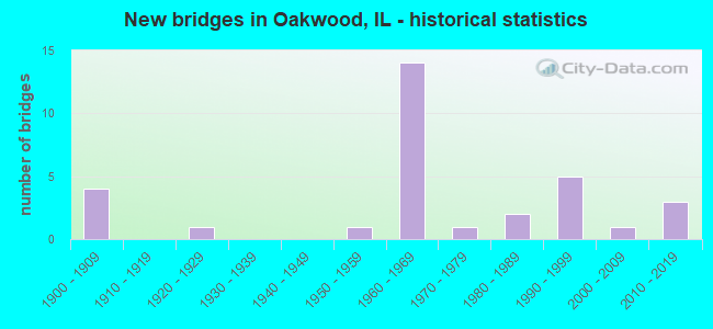
- New bridges - historical statistics
- 41900-1909
- 11920-1929
- 11950-1959
- 141960-1969
- 11970-1979
- 21980-1989
- 51990-1999
- 12000-2009
- 32010-2019

- Reconstructed bridges - Historical Statistics
- 11970-1979
- 11980-1989
- 01990-1999
- 22000-2009


- Bridge Condition - Deck
- 9.1%Very good
- 27.3%Good
- 54.5%Satisfactory
- 4.5%Fair
- 4.5%Serious

- Bridge Condition - Superstructure
- 13.6%Very good
- 9.1%Good
- 63.6%Satisfactory
- 13.6%Fair

- Bridge Condition - Substructure
- 31.8%Very good
- 36.4%Good
- 22.7%Satisfactory
- 9.1%Fair

- Bridge Condition - Channel
- 26.1%Very good
- 21.7%Good
- 52.2%Satisfactory

- Bridge Condition - Culverts
- 25.0%Good
- 75.0%Satisfactory
Find on map >> Show street view
Structure Number: 920003, Location: 4 MI W OF DANVILLE (Lat: 40.127481, Lng: -87.734214), Route carried "on" structure: Interstate 74, Year Built: 1960, Year Reconstructed: 2000, Status: Open, Structure Length: 11.11m (36.45ft), Average Daily Traffic: 12,550 (year 2021), Truck Traffic: 32%, Average Future Daily Traffic: 12,375 (year 2032), Design Load: HS 20+Mod, Features Intersected: MIDDLEFORK VERM RIV
Minimum Vertical Clearance: 30+ m (98+ ft), Kilometerpoint: 338.725, Lanes on structure: 2, Lanes under structure: 2, Base Highway Network: Yes, Owner: State Highway Agency, Approaching Roadway Width: 11.0m (36.1ft), Material/Design: Steel continuous, Design/Construction: Stringer/Multi-beam, Number Of Spans In Main Unit: 4, Length of Maximum Span: 30.5m (100.1ft), Curb-To-Curb Width: 10.2m (33.5ft), Out-to-Out Width: 11.2m (36.7ft)
Condition: Deck: Good, Superstructure: Satisfactory, Substructure: Good, Channel: Good, Operating Rating: 89.1 metric tons, Method Used To Determine Operating Rating: Load Factor (LF) rating reported by rating factor (RF) method using MS18 loading, Inventory Rating: 59.6 metric tons, Method Used To Determine Inventory Rating: Load Factor (LF) rating reported by rating factor (RF) method using MS18 loading, Structural Evaluation: Equal to present minimum criteria, Deck Geometry: Meets minimum limits, Underclear: Superior to present desirable criteria, Waterway Adequacy: Equal to present desirable criteria, Approach Roadway Alignment: Equal to present desirable criteria, Length Of Structure Improvement: 11.09m (36.38ft), Designated Inspection Frequency: Every 24 months, Inspection Date: April 2020, Bridge Improvement Cost: $786,000, Roadway Improvement Cost: $79,000, Total Project Cost: $1,179,000, Deck Structure Type: Concrete Cast-file-Place, Wearing Surface/Protective System: Deck Protection: Epoxy Coated Reinforcing
Find on map >> Show street view
Structure Number: 920004, Location: 4 MI W OF DANVILLE (Lat: 40.127481, Lng: -87.734019), Route carried "on" structure: Interstate 74, Year Built: 1960, Year Reconstructed: 2000, Status: Open, Structure Length: 11.11m (36.45ft), Average Daily Traffic: 12,550 (year 2021), Truck Traffic: 32%, Average Future Daily Traffic: 12,375 (year 2032), Design Load: HS 20+Mod, Features Intersected: MIDDLEFORK VERM RIV
Minimum Vertical Clearance: 30+ m (98+ ft), Kilometerpoint: 338.742, Lanes on structure: 2, Lanes under structure: 2, Base Highway Network: Yes, Owner: State Highway Agency, Approaching Roadway Width: 11.0m (36.1ft), Material/Design: Steel continuous, Design/Construction: Stringer/Multi-beam, Number Of Spans In Main Unit: 4, Length of Maximum Span: 30.5m (100.1ft), Curb-To-Curb Width: 10.2m (33.5ft), Out-to-Out Width: 11.2m (36.7ft)
Condition: Deck: Good, Superstructure: Satisfactory, Substructure: Good, Channel: Good, Operating Rating: 89.1 metric tons, Method Used To Determine Operating Rating: Load Factor (LF) rating reported by rating factor (RF) method using MS18 loading, Inventory Rating: 59.6 metric tons, Method Used To Determine Inventory Rating: Load Factor (LF) rating reported by rating factor (RF) method using MS18 loading, Structural Evaluation: Equal to present minimum criteria, Deck Geometry: Meets minimum limits, Underclear: Superior to present desirable criteria, Waterway Adequacy: Equal to present desirable criteria, Approach Roadway Alignment: Equal to present desirable criteria, Length Of Structure Improvement: 11.09m (36.38ft), Designated Inspection Frequency: Every 24 months, Inspection Date: April 2020, Bridge Improvement Cost: $786,000, Roadway Improvement Cost: $79,000, Total Project Cost: $1,179,000, Deck Structure Type: Concrete Cast-file-Place, Wearing Surface/Protective System: Deck Protection: Epoxy Coated Reinforcing
Find on map >> Show street view
Structure Number: 92005, Location: 2.6 MI W OF DANVILLE (Lat: 40.117225, Lng: -87.726294), Route carried "on" structure: US 150, Year Built: 1928, Year Reconstructed: 1977, Status: Open, Structure Length: 10.89m (35.73ft), Average Daily Traffic: 3,500 (year 2021), Truck Traffic: 8%, Average Future Daily Traffic: 3,646 (year 2032), Design Load: HS 20, Features Intersected: MIDDLEFORK VERM RIV
Minimum Vertical Clearance: 4.70m (15.42ft), Kilometerpoint: 344.986, Lanes on structure: 2, Base Highway Network: Yes, Owner: State Highway Agency, Approaching Roadway Width: 9.1m (29.9ft), Material/Design: Steel continuous, Design/Construction: Stringer/Multi-beam, Number Of Spans In Main Unit: 3, Length of Maximum Span: 46.3m (151.9ft), Curb-To-Curb Width: 9.3m (30.5ft), Out-to-Out Width: 10.4m (34.1ft)
Condition: Deck: Satisfactory, Superstructure: Satisfactory, Substructure: Satisfactory, Channel: Satisfactory, Operating Rating: 67.7 metric tons, Method Used To Determine Operating Rating: Load Factor (LF) rating reported by rating factor (RF) method using MS18 loading, Inventory Rating: 40.5 metric tons, Method Used To Determine Inventory Rating: Load Factor (LF) rating reported by rating factor (RF) method using MS18 loading, Structural Evaluation: Equal to present minimum criteria, Deck Geometry: Meets minimum limits, Waterway Adequacy: Equal to present desirable criteria, Approach Roadway Alignment: Equal to present desirable criteria, Designated Inspection Frequency: Every 24 months, Inspection Date: April 2020, Deck Structure Type: Concrete Cast-file-Place, Wearing Surface/Protective System: Wearing Surface: Bituminous, Membrane: Built-up
Find on map >> Show street view
Structure Number: 920075, Location: 0.5 MI N OF OAKWOOD (Lat: 40.126631, Lng: -87.778331), Route carried "on" structure: County highway , Year Built: 1960, Year Reconstructed: 1989, Status: Open, Structure Length: 5.66m (18.57ft), Average Daily Traffic: 4,200 (year 2020), Truck Traffic: 27%, Average Future Daily Traffic: 4,365 (year 2032), Design Load: HS 20, Features Intersected: I-74, Facility Carried by Structure: FAS 331
Minimum Vertical Clearance: 30+ m (98+ ft), Kilometerpoint: 43.306, Lanes on structure: 2, Lanes under structure: 4, Base Highway Network: Yes, Owner: State Highway Agency, Approaching Roadway Width: 9.1m (29.9ft), Material/Design: Prestressed concrete, Design/Construction: Stringer/Multi-beam, Number Of Spans In Main Unit: 4, Length of Maximum Span: 17.1m (56.1ft), Curb-To-Curb Width: 9.8m (32.2ft), Out-to-Out Width: 10.7m (35.1ft)
Condition: Deck: Satisfactory, Superstructure: Fair, Substructure: Fair, Operating Rating: 51.5 metric tons, Method Used To Determine Operating Rating: Load Factor (LF) rating reported by rating factor (RF) method using MS18 loading, Inventory Rating: 33.4 metric tons, Method Used To Determine Inventory Rating: Load Factor (LF) rating reported by rating factor (RF) method using MS18 loading, Structural Evaluation: Somewhat better than minimum adequacy, Deck Geometry: Meets minimum limits, Underclear: Meets minimum limits, Approach Roadway Alignment: Equal to present desirable criteria, Designated Inspection Frequency: Every 24 months, Inspection Date: April 2020, Deck Structure Type: Concrete Cast-file-Place, Wearing Surface/Protective System: Wearing Surface: Bituminous, Membrane: Built-up
Find on map >> Show street view
Structure Number: 920125, Location: 1.5 MI NE OF OAKWOOD (Lat: 40.127894, Lng: -87.753753), Route carried "on" structure: County highway , Year Built: 1960, Status: Open, Structure Length: 5.62m (18.44ft), Average Daily Traffic: 300 (year 2019), Truck Traffic: 1%, Average Future Daily Traffic: 334 (year 2032), Design Load: HS 15, Features Intersected: I-74, Facility Carried by Structure: TR 206
Minimum Vertical Clearance: 30+ m (98+ ft), Kilometerpoint: 1.223, Lanes on structure: 2, Lanes under structure: 4, Owner: State Highway Agency, Approaching Roadway Width: 6.1m (20.0ft), Material/Design: Prestressed concrete, Design/Construction: Stringer/Multi-beam, Number Of Spans In Main Unit: 4, Length of Maximum Span: 17.1m (56.1ft), Curb or Sidewalk Widths: Left: 0.6m (2.0ft), Right: 0.6m (2.0ft), Curb-To-Curb Width: 7.9m (25.9ft), Out-to-Out Width: 9.9m (32.5ft)
Condition: Deck: Good, Superstructure: Good, Substructure: Good, Operating Rating: 77.8 metric tons, Method Used To Determine Operating Rating: Load Factor (LF) rating reported by rating factor (RF) method using MS18 loading, Inventory Rating: 42.1 metric tons, Method Used To Determine Inventory Rating: Load Factor (LF) rating reported by rating factor (RF) method using MS18 loading, Structural Evaluation: Better than present minimum criteria, Deck Geometry: Somewhat better than minimum adequacy, Underclear: Meets minimum limits, Approach Roadway Alignment: Better than present minimum criteria, Designated Inspection Frequency: Every 24 months, Inspection Date: April 2020, Deck Structure Type: Concrete Cast-file-Place
Find on map >> Show street view
Structure Number: 920127, Location: 1 MI W OF US 150 (Lat: 40.127481, Lng: -87.728139), Route carried "on" structure: Other road , Year Built: 1960, Status: Open, Structure Length: 8.02m (26.31ft), Average Daily Traffic: 150 (year 2019), Average Future Daily Traffic: 112 (year 2032), Design Load: HS 15, Features Intersected: I-74, Facility Carried by Structure: TR 251 B
Minimum Vertical Clearance: 30+ m (98+ ft), Kilometerpoint: 2.012, Lanes on structure: 2, Lanes under structure: 4, Owner: State Highway Agency, Approaching Roadway Width: 5.5m (18.0ft), Skew: 2 degrees, Material/Design: Prestressed concrete, Design/Construction: Stringer/Multi-beam, Number Of Spans In Main Unit: 4, Length of Maximum Span: 19.7m (64.6ft), Curb or Sidewalk Widths: Left: 0.6m (2.0ft), Right: 0.6m (2.0ft), Curb-To-Curb Width: 7.3m (24.0ft), Out-to-Out Width: 9.3m (30.5ft)
Condition: Deck: Good, Superstructure: Good, Substructure: Good, Operating Rating: 83.9 metric tons, Method Used To Determine Operating Rating: Load Factor (LF) rating reported by rating factor (RF) method using MS18 loading, Inventory Rating: 41.5 metric tons, Method Used To Determine Inventory Rating: Load Factor (LF) rating reported by rating factor (RF) method using MS18 loading, Structural Evaluation: Better than present minimum criteria, Deck Geometry: Somewhat better than minimum adequacy, Underclear: Equal to present minimum criteria, Approach Roadway Alignment: Equal to present desirable criteria, Designated Inspection Frequency: Every 24 months, Inspection Date: April 2020, Deck Structure Type: Concrete Cast-file-Place
Find on map >> Show street view
Structure Number: 920136, Location: 2.5 MI NE FAIRMOUNT (Lat: 40.064622, Lng: -87.784939), Route carried "on" structure: County highway , Year Built: 1952, Status: Open, Structure Length: 0.66m (2.17ft), Average Daily Traffic: 2,450 (year 2019), Truck Traffic: 8%, Average Future Daily Traffic: 3,286 (year 2032), Design Load: HS 20, Features Intersected: STREAM, Facility Carried by Structure: FAS 512(CH 8)
Minimum Vertical Clearance: 30+ m (98+ ft), Kilometerpoint: 13.615, Lanes on structure: 2, Owner: County Highway Agency, Approaching Roadway Width: 6.7m (22.0ft), Material/Design: Concrete, Design/Construction: Culvert, Number Of Spans In Main Unit: 2, Length of Maximum Span: 3.0m (9.8ft)
Condition: Channel: Satisfactory, Culverts: Satisfactory, Operating Rating: 44.1 metric tons, Method Used To Determine Operating Rating: Allowable Stress (AS) rating reported by rating factor (RF) method using MS18 loading, Inventory Rating: 32.4 metric tons, Method Used To Determine Inventory Rating: Allowable Stress (AS) rating reported by rating factor (RF) method using MS18 loading, Structural Evaluation: Equal to present minimum criteria, Waterway Adequacy: Equal to present desirable criteria, Approach Roadway Alignment: Equal to present desirable criteria, Designated Inspection Frequency: Every 24 months, Inspection Date: Febuary 2021
Find on map >> Show street view
Structure Number: 920167, Location: 2 MI N OF OAKWOOD (Lat: 40.138678, Lng: -87.778489), Route carried "on" structure: County highway , Year Built: 1967, Status: Open, Structure Length: 0.77m (2.53ft), Average Daily Traffic: 1,800 (year 2020), Truck Traffic: 14%, Average Future Daily Traffic: 2,054 (year 2032), Design Load: HS 20, Features Intersected: STREAM, Facility Carried by Structure: FAS 331
Minimum Vertical Clearance: 30+ m (98+ ft), Kilometerpoint: 42.003, Lanes on structure: 2, Owner: State Highway Agency, Approaching Roadway Width: 7.3m (24.0ft), Skew: 4 degrees, Material/Design: Concrete continuous, Design/Construction: Culvert, Number Of Spans In Main Unit: 2, Length of Maximum Span: 3.7m (12.1ft)
Condition: Channel: Satisfactory, Culverts: Satisfactory, Operating Rating: 89.1 metric tons, Method Used To Determine Operating Rating: Field evaluation and documented engineering judgment, Inventory Rating: 89.1 metric tons, Method Used To Determine Inventory Rating: Field evaluation and documented engineering judgment, Structural Evaluation: Equal to present minimum criteria, Waterway Adequacy: Equal to present desirable criteria, Approach Roadway Alignment: Equal to present desirable criteria, Designated Inspection Frequency: Every 24 months, Inspection Date: April 2020
Find on map >> Show street view
Structure Number: 920177, Location: 2.25 MI S OAKWOOD (Lat: 40.083181, Lng: -87.780411), Route carried "on" structure: County highway , Year Built: 1980, Status: Open, Structure Length: 12.16m (39.90ft), Average Daily Traffic: 2,100 (year 2020), Truck Traffic: 11%, Average Future Daily Traffic: 2,568 (year 2032), Design Load: HS 20, Features Intersected: SALT FORK, Facility Carried by Structure: FAS 331(CH 10)
Minimum Vertical Clearance: 30+ m (98+ ft), Kilometerpoint: 48.199, Lanes on structure: 2, Owner: State Highway Agency, Approaching Roadway Width: 6.7m (22.0ft), Skew: 4 degrees, Material/Design: Steel continuous, Design/Construction: Stringer/Multi-beam, Number Of Spans In Main Unit: 3, Length of Maximum Span: 49.1m (161.1ft), Curb-To-Curb Width: 9.1m (29.9ft), Out-to-Out Width: 10.1m (33.1ft)
Condition: Deck: Satisfactory, Superstructure: Fair, Substructure: Good, Channel: Very good, Operating Rating: 61.9 metric tons, Method Used To Determine Operating Rating: Load Factor (LF) rating reported by rating factor (RF) method using MS18 loading, Inventory Rating: 37.3 metric tons, Method Used To Determine Inventory Rating: Load Factor (LF) rating reported by rating factor (RF) method using MS18 loading, Structural Evaluation: Somewhat better than minimum adequacy, Deck Geometry: Meets minimum limits, Waterway Adequacy: Equal to present desirable criteria, Approach Roadway Alignment: Equal to present desirable criteria, Length Of Structure Improvement: 12.16m (39.90ft), Designated Inspection Frequency: Every 24 months, Inspection Date: May 2021, Bridge Improvement Cost: $795,000, Roadway Improvement Cost: $79,000, Total Project Cost: $1,193,000, Deck Structure Type: Concrete Cast-file-Place
Find on map >> Show street view
Structure Number: 920194, Location: 3 MI W OF CATLIN (Lat: 40.065361, Lng: -87.768525), Route carried "on" structure: County highway , Year Built: 1992, Status: Open, Structure Length: 2.29m (7.51ft), Average Daily Traffic: 2,450 (year 2019), Truck Traffic: 8%, Average Future Daily Traffic: 3,286 (year 2032), Design Load: HS 20, Features Intersected: STREAM, Facility Carried by Structure: FAS 512(CH 8)
Minimum Vertical Clearance: 30+ m (98+ ft), Kilometerpoint: 15.031, Lanes on structure: 2, Owner: County Highway Agency, Approaching Roadway Width: 6.7m (22.0ft), Skew: 3 degrees, Material/Design: Prestressed concrete, Design/Construction: Stringer/Multi-beam, Number Of Spans In Main Unit: 1, Length of Maximum Span: 22.0m (72.2ft), Curb-To-Curb Width: 9.1m (29.9ft), Out-to-Out Width: 10.1m (33.1ft)
Condition: Deck: Good, Superstructure: Very good, Substructure: Very good, Channel: Satisfactory, Operating Rating: 89.1 metric tons, Method Used To Determine Operating Rating: Load Factor (LF) rating reported by rating factor (RF) method using MS18 loading, Inventory Rating: 36.9 metric tons, Method Used To Determine Inventory Rating: Load Factor (LF) rating reported by rating factor (RF) method using MS18 loading, Structural Evaluation: Equal to present desirable criteria, Deck Geometry: Meets minimum limits, Waterway Adequacy: Equal to present desirable criteria, Approach Roadway Alignment: Equal to present desirable criteria, Designated Inspection Frequency: Every 48 months, Inspection Date: Febuary 2021, Deck Structure Type: Concrete Cast-file-Place, Wearing Surface/Protective System: Wearing Surface: Bituminous, Deck Protection: Epoxy Coated Reinforcing
Find on map >> Show street view
Structure Number: 922008, Location: 1.75 MI N OF OAKWOOD (Lat: 40.142081, Lng: -87.776839), Route carried "on" structure: County highway , Year Built: 1967, Status: Open, Structure Length: 0.75m (2.46ft), Average Daily Traffic: 1,300 (year 2020), Truck Traffic: 12%, Average Future Daily Traffic: 1,541 (year 2032), Design Load: HS 20, Features Intersected: GLENBURN CREEK, Facility Carried by Structure: FAS 331
Minimum Vertical Clearance: 30+ m (98+ ft), Kilometerpoint: 41.584, Lanes on structure: 2, Owner: State Highway Agency, Approaching Roadway Width: 7.3m (24.0ft), Skew: 1 degrees, Material/Design: Concrete continuous, Design/Construction: Culvert, Number Of Spans In Main Unit: 2, Length of Maximum Span: 3.6m (11.8ft)
Condition: Channel: Satisfactory, Culverts: Good, Operating Rating: 89.1 metric tons, Method Used To Determine Operating Rating: Field evaluation and documented engineering judgment, Inventory Rating: 89.1 metric tons, Method Used To Determine Inventory Rating: Field evaluation and documented engineering judgment, Structural Evaluation: Better than present minimum criteria, Waterway Adequacy: Equal to present desirable criteria, Approach Roadway Alignment: Better than present minimum criteria, Designated Inspection Frequency: Every 24 months, Inspection Date: April 2020
Find on map >> Show street view
Structure Number: 923086, Location: 2.5 MI NE FAIRMOUNT (Lat: 40.080153, Lng: -87.809414), Route carried "on" structure: County highway , Year Built: 1900, Status: Open, Structure Length: 0.98m (3.22ft), Average Daily Traffic: 50 (year 2019), Truck Traffic: 4%, Average Future Daily Traffic: 61 (year 2032), Features Intersected: JORDAN CREEK, Facility Carried by Structure: TR 84 A
Minimum Vertical Clearance: 30+ m (98+ ft), Kilometerpoint: 3.251, Lanes on structure: 2, Owner: Town or Township Highway Agency, Approaching Roadway Width: 6.1m (20.0ft), Skew: 3 degrees, Material/Design: Concrete, Design/Construction: Slab, Number Of Spans In Main Unit: 1, Length of Maximum Span: 9.4m (30.8ft), Curb-To-Curb Width: 6.7m (22.0ft), Out-to-Out Width: 8.2m (26.9ft)
Condition: Deck: Fair, Superstructure: Fair, Substructure: Fair, Channel: Satisfactory, Operating Rating: 40.5 metric tons, Method Used To Determine Operating Rating: Field evaluation and documented engineering judgment, Inventory Rating: 24.3 metric tons, Method Used To Determine Inventory Rating: Field evaluation and documented engineering judgment, Structural Evaluation: Somewhat better than minimum adequacy, Deck Geometry: Somewhat better than minimum adequacy, Waterway Adequacy: Equal to present minimum criteria, Approach Roadway Alignment: Somewhat better than minimum adequacy, Designated Inspection Frequency: Every 24 months, Inspection Date: Febuary 2021, Deck Structure Type: Concrete Cast-file-Place
Find on map >> Show street view
Structure Number: 92312, Location: 2.5 MI S NEWTOWN (Lat: 40.142053, Lng: -87.769519), Route carried "on" structure: County highway , Year Built: 1900, Status: Open, Structure Length: 1.16m (3.81ft), Average Daily Traffic: 50 (year 2019), Truck Traffic: 4%, Average Future Daily Traffic: 61 (year 2032), Features Intersected: GLENBURN CREEK, Facility Carried by Structure: TR 148
Minimum Vertical Clearance: 30+ m (98+ ft), Kilometerpoint: 0.869, Lanes on structure: 1, Owner: Town or Township Highway Agency, Approaching Roadway Width: 6.1m (20.0ft), Material/Design: Concrete, Number Of Spans In Main Unit: 1, Length of Maximum Span: 11.3m (37.1ft), Curb-To-Curb Width: 5.8m (19.0ft), Out-to-Out Width: 5.8m (19.0ft)
Condition: Deck: Satisfactory, Superstructure: Satisfactory, Substructure: Satisfactory, Channel: Satisfactory, Operating Rating: 40.5 metric tons, Method Used To Determine Operating Rating: Field evaluation and documented engineering judgment, Inventory Rating: 24.3 metric tons, Method Used To Determine Inventory Rating: Field evaluation and documented engineering judgment, Structural Evaluation: Equal to present minimum criteria, Deck Geometry: Meets minimum limits, Waterway Adequacy: Equal to present minimum criteria, Approach Roadway Alignment: Better than present minimum criteria, Designated Inspection Frequency: Every 24 months, Inspection Date: Febuary 2022, Deck Structure Type: Concrete Cast-file-Place, Wearing Surface/Protective System: Wearing Surface: Gravel
Find on map >> Show street view
Structure Number: 923171, Location: 1 MI N OAKWOOD (Lat: 40.133950, Lng: -87.779919), Route carried "on" structure: County highway , Year Built: 1961, Status: Open, Structure Length: 0.85m (2.79ft), Average Daily Traffic: 100 (year 2019), Truck Traffic: 4%, Average Future Daily Traffic: 112 (year 2032), Design Load: HS 15, Features Intersected: STREAM, Facility Carried by Structure: TR 261
Minimum Vertical Clearance: 30+ m (98+ ft), Kilometerpoint: 14.033, Lanes on structure: 2, Owner: Town or Township Highway Agency, Approaching Roadway Width: 6.7m (22.0ft), Skew: 3 degrees, Material/Design: Prestressed concrete, Design/Construction: Box Beam or Girders - Multiple, Number Of Spans In Main Unit: 1, Length of Maximum Span: 8.2m (26.9ft), Curb-To-Curb Width: 6.7m (22.0ft), Out-to-Out Width: 7.3m (24.0ft)
Condition: Deck: Satisfactory, Superstructure: Satisfactory, Substructure: Satisfactory, Channel: Satisfactory, Operating Rating: 72.3 metric tons, Method Used To Determine Operating Rating: Load Factor (LF) rating reported by rating factor (RF) method using MS18 loading, Inventory Rating: 43.4 metric tons, Method Used To Determine Inventory Rating: Load Factor (LF) rating reported by rating factor (RF) method using MS18 loading, Structural Evaluation: Equal to present minimum criteria, Deck Geometry: Somewhat better than minimum adequacy, Waterway Adequacy: Equal to present minimum criteria, Approach Roadway Alignment: Better than present minimum criteria, Designated Inspection Frequency: Every 24 months, Inspection Date: Febuary 2021, Deck Structure Type: Concrete Precast Panels, Wearing Surface/Protective System: Wearing Surface: Gravel
Find on map >> Show street view
Structure Number: 923342, Location: 2 MI NE OAKWOOD (Lat: 40.138675, Lng: -87.753308), Route carried "on" structure: County highway , Year Built: 1983, Status: Open, Structure Length: 3.23m (10.60ft), Average Daily Traffic: 300 (year 2019), Truck Traffic: 1%, Average Future Daily Traffic: 334 (year 2032), Design Load: HS 20, Features Intersected: GLENBURN CREEK, Facility Carried by Structure: TR 206
Minimum Vertical Clearance: 30+ m (98+ ft), Kilometerpoint: 0.016, Lanes on structure: 2, Owner: Town or Township Highway Agency, Approaching Roadway Width: 7.3m (24.0ft), Skew: 1 degrees, Material/Design: Concrete, Design/Construction: Channel Beam, Number Of Spans In Main Unit: 3, Length of Maximum Span: 11.6m (38.1ft), Curb-To-Curb Width: 8.0m (26.2ft), Out-to-Out Width: 8.1m (26.6ft)
Condition: Deck: Satisfactory, Superstructure: Satisfactory, Substructure: Good, Channel: Satisfactory, Operating Rating: 49.2 metric tons, Method Used To Determine Operating Rating: Allowable Stress (AS) rating reported by rating factor (RF) method using MS18 loading, Inventory Rating: 29.5 metric tons, Method Used To Determine Inventory Rating: Allowable Stress (AS) rating reported by rating factor (RF) method using MS18 loading, Structural Evaluation: Equal to present minimum criteria, Deck Geometry: Somewhat better than minimum adequacy, Waterway Adequacy: Equal to present desirable criteria, Approach Roadway Alignment: Better than present minimum criteria, Designated Inspection Frequency: Every 24 months, Inspection Date: Febuary 2021, Deck Structure Type: Concrete Cast-file-Place, Wearing Surface/Protective System: Wearing Surface: Gravel
Find on map >> Show street view
Structure Number: 923412, Location: 2.5 MI N OF OAKWOOD (Lat: 40.150811, Lng: -87.790025), Route carried "on" structure: County highway , Year Built: 1992, Status: Open, Structure Length: 1.35m (4.43ft), Average Daily Traffic: 50 (year 2019), Truck Traffic: 4%, Average Future Daily Traffic: 61 (year 2032), Design Load: HS 20, Features Intersected: GLENBURN CREEK BR, Facility Carried by Structure: TR 231
Minimum Vertical Clearance: 30+ m (98+ ft), Kilometerpoint: 3.203, Lanes on structure: 2, Owner: Town or Township Highway Agency, Approaching Roadway Width: 5.5m (18.0ft), Skew: 1 degrees, Material/Design: Prestressed concrete, Design/Construction: Box Beam or Girders - Multiple, Number Of Spans In Main Unit: 1, Length of Maximum Span: 12.0m (39.4ft), Curb-To-Curb Width: 8.2m (26.9ft), Out-to-Out Width: 8.2m (26.9ft)
Condition: Deck: Satisfactory, Superstructure: Satisfactory, Substructure: Very good, Channel: Very good, Operating Rating: 44.1 metric tons, Method Used To Determine Operating Rating: Assigned rating based on Load Factor Design (LFD) reported by rating factor (RF) using MS18 loading, Inventory Rating: 32.4 metric tons, Method Used To Determine Inventory Rating: Assigned rating based on Load Factor Design (LFD) reported by rating factor (RF) using MS18 loading, Structural Evaluation: Equal to present minimum criteria, Deck Geometry: Equal to present minimum criteria, Waterway Adequacy: Equal to present desirable criteria, Approach Roadway Alignment: Equal to present desirable criteria, Designated Inspection Frequency: Every 24 months, Inspection Date: Febuary 2021, Deck Structure Type: Concrete Precast Panels, Wearing Surface/Protective System: Wearing Surface: Gravel
Find on map >> Show street view
Structure Number: 92342, Location: 1 MI N OF OAKWOOD (Lat: 40.142058, Lng: -87.772383), Route carried "on" structure: County highway , Year Built: 2000, Status: Open, Structure Length: 2.48m (8.14ft), Average Daily Traffic: 475 (year 2019), Truck Traffic: 2%, Average Future Daily Traffic: 565 (year 2032), Design Load: HS 20+Mod, Features Intersected: GLENBURN CREEK, Facility Carried by Structure: FAS 1507(TR 249)
Minimum Vertical Clearance: 30+ m (98+ ft), Kilometerpoint: 0.547, Lanes on structure: 2, Owner: Town or Township Highway Agency, Approaching Roadway Width: 7.3m (24.0ft), Skew: 4 degrees, Material/Design: Prestressed concrete, Design/Construction: Box Beam or Girders - Multiple, Number Of Spans In Main Unit: 1, Length of Maximum Span: 24.0m (78.7ft), Curb-To-Curb Width: 9.1m (29.9ft), Out-to-Out Width: 9.1m (29.9ft)
Condition: Deck: Satisfactory, Superstructure: Satisfactory, Substructure: Satisfactory, Channel: Satisfactory, Operating Rating: 44.1 metric tons, Method Used To Determine Operating Rating: Load Factor (LF) rating reported by rating factor (RF) method using MS18 loading, Inventory Rating: 32.4 metric tons, Method Used To Determine Inventory Rating: Load Factor (LF) rating reported by rating factor (RF) method using MS18 loading, Structural Evaluation: Equal to present minimum criteria, Deck Geometry: Equal to present minimum criteria, Waterway Adequacy: Superior to present desirable criteria, Approach Roadway Alignment: Equal to present minimum criteria, Designated Inspection Frequency: Every 24 months, Inspection Date: Febuary 2022, Deck Structure Type: Concrete Precast Panels, Wearing Surface/Protective System: Wearing Surface: Bituminous, Membrane: Built-up
Find on map >> Show street view
Structure Number: 923426, Location: 2.5 MI NE FAIRMOUNT (Lat: 40.079550, Lng: -87.808411), Route carried "on" structure: County highway , Year Built: 1998, Status: Open, Structure Length: 3.45m (11.32ft), Average Daily Traffic: 50 (year 2019), Truck Traffic: 4%, Average Future Daily Traffic: 61 (year 2032), Design Load: HS 20, Features Intersected: JORDAN CREEK, Facility Carried by Structure: TR 315
Minimum Vertical Clearance: 30+ m (98+ ft), Kilometerpoint: 0.097, Lanes on structure: 2, Owner: Town or Township Highway Agency, Approaching Roadway Width: 4.3m (14.1ft), Skew: 1 degrees, Material/Design: Prestressed concrete, Design/Construction: Box Beam or Girders - Multiple, Number Of Spans In Main Unit: 3, Length of Maximum Span: 15.2m (49.9ft), Curb-To-Curb Width: 8.2m (26.9ft), Out-to-Out Width: 8.2m (26.9ft)
Condition: Deck: Satisfactory, Superstructure: Satisfactory, Substructure: Very good, Channel: Good, Operating Rating: 44.1 metric tons, Method Used To Determine Operating Rating: Assigned rating based on Load Factor Design (LFD) reported by rating factor (RF) using MS18 loading, Inventory Rating: 32.4 metric tons, Method Used To Determine Inventory Rating: Assigned rating based on Load Factor Design (LFD) reported by rating factor (RF) using MS18 loading, Structural Evaluation: Equal to present minimum criteria, Deck Geometry: Equal to present minimum criteria, Waterway Adequacy: Equal to present desirable criteria, Approach Roadway Alignment: Equal to present minimum criteria, Designated Inspection Frequency: Every 24 months, Inspection Date: Febuary 2022, Deck Structure Type: Concrete Precast Panels
Find on map >> Show street view
Structure Number: 923471, Location: 3 MI NW OF CATLIN (Lat: 40.079614, Lng: -87.769753), Route carried "on" structure: County highway , Year Built: 1997, Status: Open, Structure Length: 2.16m (7.09ft), Average Daily Traffic: 125 (year 2019), Truck Traffic: 6%, Average Future Daily Traffic: 257 (year 2032), Design Load: HS 20, Features Intersected: SALT FORK TRIB, Facility Carried by Structure: TR 317
Minimum Vertical Clearance: 30+ m (98+ ft), Kilometerpoint: 1.062, Lanes on structure: 2, Owner: Town or Township Highway Agency, Approaching Roadway Width: 6.7m (22.0ft), Skew: 2 degrees, Material/Design: Prestressed concrete, Design/Construction: Box Beam or Girders - Multiple, Number Of Spans In Main Unit: 1, Length of Maximum Span: 21.2m (69.6ft), Curb-To-Curb Width: 8.2m (26.9ft), Out-to-Out Width: 8.2m (26.9ft)
Condition: Deck: Satisfactory, Superstructure: Satisfactory, Substructure: Very good, Channel: Good, Operating Rating: 44.1 metric tons, Method Used To Determine Operating Rating: Assigned rating based on Load Factor Design (LFD) reported by rating factor (RF) using MS18 loading, Inventory Rating: 32.4 metric tons, Method Used To Determine Inventory Rating: Assigned rating based on Load Factor Design (LFD) reported by rating factor (RF) using MS18 loading, Structural Evaluation: Equal to present minimum criteria, Deck Geometry: Somewhat better than minimum adequacy, Waterway Adequacy: Equal to present desirable criteria, Approach Roadway Alignment: Equal to present desirable criteria, Designated Inspection Frequency: Every 24 months, Inspection Date: Febuary 2022, Deck Structure Type: Concrete Precast Panels, Wearing Surface/Protective System: Wearing Surface: Gravel
Find on map >> Show street view
Structure Number: 923472, Location: 3.5 MI W OF CATLIN (Lat: 40.082869, Lng: -87.766136), Route carried "on" structure: County highway , Year Built: 1999, Status: Open, Structure Length: 1.67m (5.48ft), Average Daily Traffic: 125 (year 2019), Truck Traffic: 6%, Average Future Daily Traffic: 257 (year 2032), Design Load: HS 20, Features Intersected: SALT FORK TRIB, Facility Carried by Structure: TR 317
Minimum Vertical Clearance: 30+ m (98+ ft), Kilometerpoint: 1.561, Lanes on structure: 2, Owner: Town or Township Highway Agency, Approaching Roadway Width: 6.1m (20.0ft), Skew: 1 degrees, Material/Design: Prestressed concrete, Design/Construction: Box Beam or Girders - Multiple, Number Of Spans In Main Unit: 1, Length of Maximum Span: 15.8m (51.8ft), Curb-To-Curb Width: 8.2m (26.9ft), Out-to-Out Width: 8.2m (26.9ft)
Condition: Deck: Satisfactory, Superstructure: Satisfactory, Substructure: Very good, Channel: Satisfactory, Operating Rating: 44.1 metric tons, Method Used To Determine Operating Rating: Assigned rating based on Load Factor Design (LFD) reported by rating factor (RF) using MS18 loading, Inventory Rating: 32.4 metric tons, Method Used To Determine Inventory Rating: Assigned rating based on Load Factor Design (LFD) reported by rating factor (RF) using MS18 loading, Structural Evaluation: Equal to present minimum criteria, Deck Geometry: Somewhat better than minimum adequacy, Waterway Adequacy: Equal to present desirable criteria, Approach Roadway Alignment: Equal to present minimum criteria, Designated Inspection Frequency: Every 24 months, Inspection Date: Febuary 2022, Deck Structure Type: Concrete Precast Panels, Wearing Surface/Protective System: Wearing Surface: Gravel
Find on map >> Show street view
Structure Number: 923513, Location: 2.5 MI W NEWTOWN (Lat: 40.166233, Lng: -87.816494), Route carried "on" structure: County highway , Year Built: 2011, Status: Open, Structure Length: 1.44m (4.72ft), Average Daily Traffic: 75 (year 2019), Truck Traffic: 3%, Average Future Daily Traffic: 77 (year 2032), Design Load: HS 25 or greater, Features Intersected: STREAM, Facility Carried by Structure: TR 225
Minimum Vertical Clearance: 30+ m (98+ ft), Kilometerpoint: 2.430, Lanes on structure: 2, Owner: Town or Township Highway Agency, Approaching Roadway Width: 7.3m (24.0ft), Material/Design: Prestressed concrete, Design/Construction: Box Beam or Girders - Multiple, Number Of Spans In Main Unit: 1, Length of Maximum Span: 13.7m (44.9ft), Curb-To-Curb Width: 8.2m (26.9ft), Out-to-Out Width: 8.2m (26.9ft)
Condition: Deck: Very good, Superstructure: Very good, Substructure: Very good, Channel: Very good, Operating Rating: 44.1 metric tons, Method Used To Determine Operating Rating: Assigned rating based on Load Factor Design (LFD) reported by rating factor (RF) using MS18 loading, Inventory Rating: 32.4 metric tons, Method Used To Determine Inventory Rating: Assigned rating based on Load Factor Design (LFD) reported by rating factor (RF) using MS18 loading, Structural Evaluation: Equal to present desirable criteria, Deck Geometry: Equal to present minimum criteria, Waterway Adequacy: Better than present minimum criteria, Approach Roadway Alignment: Equal to present minimum criteria, Designated Inspection Frequency: Every 48 months, Inspection Date: January 2021, Deck Structure Type: Concrete Precast Panels, Wearing Surface/Protective System: Wearing Surface: Gravel
Find on map >> Show street view
Structure Number: 923519, Location: 5 mi West of Catlin (Lat: 40.076950, Lng: -87.800469), Route carried "on" structure: County highway , Year Built: 2017, Status: Open, Structure Length: 2.26m (7.41ft), Average Daily Traffic: 50 (year 2019), Truck Traffic: 4%, Average Future Daily Traffic: 51 (year 2038), Design Load: HS 25 or greater, Features Intersected: Jordan Creek, Facility Carried by Structure: TR 315
Minimum Vertical Clearance: 30+ m (98+ ft), Kilometerpoint: 0.853, Lanes on structure: 2, Owner: Town or Township Highway Agency, Approaching Roadway Width: 5.5m (18.0ft), Material/Design: Prestressed concrete, Design/Construction: Box Beam or Girders - Multiple, Number Of Spans In Main Unit: 1, Length of Maximum Span: 21.9m (71.9ft), Curb-To-Curb Width: 8.2m (26.9ft), Out-to-Out Width: 8.2m (26.9ft)
Condition: Deck: Very good, Superstructure: Very good, Substructure: Very good, Channel: Very good, Operating Rating: 42.1 metric tons, Method Used To Determine Operating Rating: Assigned ratings based on Load and Resistance Factor Design (LRFD) reported by rating factor (RF) using HL93 loadings, Inventory Rating: 32.4 metric tons, Method Used To Determine Inventory Rating: Assigned ratings based on Load and Resistance Factor Design (LRFD) reported by rating factor (RF) using HL93 loadings, Structural Evaluation: Equal to present desirable criteria, Deck Geometry: Equal to present minimum criteria, Waterway Adequacy: Equal to present desirable criteria, Approach Roadway Alignment: Equal to present minimum criteria, Designated Inspection Frequency: Every 48 months, Inspection Date: Febuary 2019, Deck Structure Type: Concrete Precast Panels
Find on map >> Show street view
Structure Number: 926003, Location: In Oakwood (Lat: 40.103458, Lng: -87.771275), Route carried "on" structure: City street , Year Built: 2015, Status: Open, Structure Length: 2.48m (8.14ft), Average Daily Traffic: 325 (year 2019), Truck Traffic: 2%, Average Future Daily Traffic: 25 (year 2038), Design Load: HS 25 or greater, Features Intersected: Trib. of Salt Fork, Facility Carried by Structure: Kelly Drive
Minimum Vertical Clearance: 30+ m (98+ ft), Kilometerpoint: 0.290, Lanes on structure: 2, Owner: City or Municipal Highway Agency, Approaching Roadway Width: 6.7m (22.0ft), Material/Design: Prestressed concrete, Design/Construction: Box Beam or Girders - Multiple, Number Of Spans In Main Unit: 1, Length of Maximum Span: 24.0m (78.7ft), Curb-To-Curb Width: 8.2m (26.9ft), Out-to-Out Width: 8.2m (26.9ft)
Condition: Deck: Satisfactory, Superstructure: Satisfactory, Substructure: Good, Channel: Very good, Operating Rating: 42.1 metric tons, Method Used To Determine Operating Rating: Assigned ratings based on Load and Resistance Factor Design (LRFD) reported by rating factor (RF) using HL93 loadings, Inventory Rating: 32.4 metric tons, Method Used To Determine Inventory Rating: Assigned ratings based on Load and Resistance Factor Design (LRFD) reported by rating factor (RF) using HL93 loadings, Structural Evaluation: Equal to present minimum criteria, Deck Geometry: Somewhat better than minimum adequacy, Waterway Adequacy: Superior to present desirable criteria, Approach Roadway Alignment: Equal to present desirable criteria, Designated Inspection Frequency: Every 24 months, Inspection Date: Febuary 2022, Deck Structure Type: Concrete Precast Panels
Find on map >> Show street view
Structure Number: 926006, Location: IN OAKWOOD (Lat: 40.110900, Lng: -87.778189), Route carried "on" structure: County highway , Year Built: 1973, Status: Open, Structure Length: 1.10m (3.61ft), Average Daily Traffic: 2,450 (year 2020), Truck Traffic: 8%, Average Future Daily Traffic: 3,184 (year 2032), Design Load: HS 20, Features Intersected: STREAM, Facility Carried by Structure: FAS 331 (CH 10)
Minimum Vertical Clearance: 30+ m (98+ ft), Kilometerpoint: 45.093, Lanes on structure: 2, Base Highway Network: Yes, Owner: City or Municipal Highway Agency, Approaching Roadway Width: 13.4m (44.0ft), Skew: 4 degrees, Material/Design: Concrete continuous, Design/Construction: Culvert, Number Of Spans In Main Unit: 2, Length of Maximum Span: 5.4m (17.7ft), Curb or Sidewalk Widths: Left: 1.2m (3.9ft), Right: 1.2m (3.9ft)
Condition: Channel: Very good, Culverts: Satisfactory, Operating Rating: 48.6 metric tons, Method Used To Determine Operating Rating: Load Factor (LF) rating reported by rating factor (RF) method using MS18 loading, Inventory Rating: 29.2 metric tons, Method Used To Determine Inventory Rating: Load Factor (LF) rating reported by rating factor (RF) method using MS18 loading, Structural Evaluation: Equal to present minimum criteria, Waterway Adequacy: Equal to present minimum criteria, Approach Roadway Alignment: Equal to present desirable criteria, Designated Inspection Frequency: Every 24 months, Inspection Date: Febuary 2021
Find on map >> Show street view
Structure Number: 929903, Location: KICKAPOO STATE PARK (Lat: 40.136900, Lng: -87.746097), Route carried "on" structure: County highway , Year Built: 1965, Status: Open, Structure Length: 5.91m (19.39ft), Average Daily Traffic: 475 (year 2019), Truck Traffic: 2%, Average Future Daily Traffic: 565 (year 2032), Design Load: HS 20, Features Intersected: MID FK VERMILION RIV, Facility Carried by Structure: FAS 1507
Minimum Vertical Clearance: 30+ m (98+ ft), Kilometerpoint: 3.009, Lanes on structure: 2, Owner: State Park, Forest, or Reservation Agency, Approaching Roadway Width: 6.9m (22.6ft), Skew: 1 degrees, Material/Design: Steel continuous, Design/Construction: Stringer/Multi-beam, Number Of Spans In Main Unit: 3, Length of Maximum Span: 21.3m (69.9ft), Curb or Sidewalk Widths: Left: 1.5m (4.9ft), Right: 0.6m (2.0ft), Curb-To-Curb Width: 8.5m (27.9ft), Out-to-Out Width: 11.2m (36.7ft)
Condition: Deck: Good, Superstructure: Satisfactory, Substructure: Good, Channel: Good, Operating Rating: 52.5 metric tons, Method Used To Determine Operating Rating: Load Factor (LF) rating reported by rating factor (RF) method using MS18 loading, Inventory Rating: 31.4 metric tons, Method Used To Determine Inventory Rating: Load Factor (LF) rating reported by rating factor (RF) method using MS18 loading, Structural Evaluation: Equal to present minimum criteria, Deck Geometry: Somewhat better than minimum adequacy, Waterway Adequacy: Equal to present desirable criteria, Approach Roadway Alignment: Equal to present desirable criteria, Designated Inspection Frequency: Every 24 months, Inspection Date: March 2020, Deck Structure Type: Concrete Cast-file-Place, Wearing Surface/Protective System: Wearing Surface: Low Slump Concrete
Find on map >> Show street view
Structure Number: 929904, Location: KICKAPOO STATE PARK (Lat: 40.122800, Lng: -87.735439), Route carried "on" structure: Other road , Year Built: 1900, Status: Closed, Structure Length: 7.30m (23.95ft), Average Daily Traffic: 25 (year 2017), Average Future Daily Traffic: 30 (year 2032), Features Intersected: MID FK VERMILION RIV, Facility Carried by Structure: OR 15
Minimum Vertical Clearance: 30+ m (98+ ft), Kilometerpoint: 0.225, Lanes on structure: 1, Owner: State Park, Forest, or Reservation Agency, Approaching Roadway Width: 6.1m (20.0ft), Material/Design: Steel, Design/Construction: Stringer/Multi-beam, Number Of Spans In Main Unit: 5, Length of Maximum Span: 18.7m (61.4ft), Curb-To-Curb Width: 5.1m (16.7ft), Out-to-Out Width: 5.5m (18.0ft)
Condition: Deck: Serious, Superstructure: Satisfactory, Substructure: Satisfactory, Channel: Satisfactory, Operating Rating: 28.5 metric tons, Method Used To Determine Operating Rating: Load Factor (LF) rating reported by rating factor (RF) method using MS18 loading, Inventory Rating: 16.8 metric tons, Method Used To Determine Inventory Rating: Load Factor (LF) rating reported by rating factor (RF) method using MS18 loading, Structural Evaluation: Somewhat better than minimum adequacy, Deck Geometry: High priority of corrective action, Waterway Adequacy: Equal to present minimum criteria, Approach Roadway Alignment: Equal to present desirable criteria, Bridge Posting: Required (Relationship of Operating Rating to Maximum Legal Load: 0.1 - 9.9% below), Length Of Structure Improvement: 8.05m (26.41ft), Designated Inspection Frequency: Every 24 months, Inspection Date: March 2020, Bridge Improvement Cost: $375,000, Roadway Improvement Cost: $38,000, Total Project Cost: $563,000, Deck Structure Type: Wood or Timber, Wearing Surface/Protective System: Wearing Surface: Wood or Timber
Find on map >> Show street view
Structure Number: 920003, Location: 4 MI W OF DANVILLE (Lat: 40.127481, Lng: -87.734019), Route carried "under" structure: Other road , Year Built: 1960, Structure Length: 0. m, Average Daily Traffic: 150 (year 2019), Features Intersected: MIDDLEFORK VERM RIV, Facility Carried by Structure: I-74 (EB)
Minimum Vertical Clearance: 5.46m (17.91ft), Kilometerpoint: 2.076, Lanes on structure: 2, Lanes under structure: 2, Material/Design: Steel continuous, Design/Construction: Stringer/Multi-beam, Length of Maximum Span: 30.5m (100.1ft)
Find on map >> Show street view
Structure Number: 920004, Location: 4 MI W OF DANVILLE (Lat: 40.127278, Lng: -87.734019), Route carried "under" structure: Other road , Year Built: 1960, Structure Length: 0. m, Average Daily Traffic: 150 (year 2019), Features Intersected: MIDDLEFORK VERM RIV, Facility Carried by Structure: I-74 (WB)
Minimum Vertical Clearance: 5.31m (17.42ft), Kilometerpoint: 2.108, Lanes on structure: 2, Lanes under structure: 2, Material/Design: Steel continuous, Design/Construction: Stringer/Multi-beam, Length of Maximum Span: 30.5m (100.1ft)
Find on map >> Show street view
Structure Number: 920075, Location: 0.5 MI N OF OAKWOOD (Lat: 40.126631, Lng: -87.778331), Route carried "under" structure: Interstate 74, Year Built: 1960, Structure Length: 0. m, Average Daily Traffic: 25,100 (year 2021), Truck Traffic: 32%, Features Intersected: I-74, Facility Carried by Structure: FAS 331
Minimum Vertical Clearance: 5.05m (16.57ft), Kilometerpoint: 335.024, Lanes on structure: 2, Lanes under structure: 4, Material/Design: Prestressed concrete, Design/Construction: Stringer/Multi-beam, Length of Maximum Span: 17.1m (56.1ft)
Find on map >> Show street view
Structure Number: 920125, Location: 1.5 MI NE OF OAKWOOD (Lat: 40.127531, Lng: -87.753750), Route carried "under" structure: Interstate 74, Year Built: 1960, Structure Length: 0. m, Average Daily Traffic: 25,100 (year 2021), Truck Traffic: 32%, Features Intersected: I-74, Facility Carried by Structure: TR 206
Minimum Vertical Clearance: 4.85m (15.91ft), Kilometerpoint: 337.116, Lanes on structure: 2, Lanes under structure: 4, Material/Design: Prestressed concrete, Design/Construction: Stringer/Multi-beam, Length of Maximum Span: 17.1m (56.1ft)
Find on map >> Show street view
Structure Number: 920127, Location: 1 MI W OF US 150 (Lat: 40.127481, Lng: -87.728139), Route carried "under" structure: Interstate 74, Year Built: 1960, Structure Length: 0. m, Average Daily Traffic: 25,100 (year 2021), Truck Traffic: 32%, Features Intersected: I-74, Facility Carried by Structure: TR 251 B
Minimum Vertical Clearance: 7.77m (25.49ft), Kilometerpoint: 339.305, Lanes on structure: 2, Lanes under structure: 4, Material/Design: Prestressed concrete, Design/Construction: Stringer/Multi-beam, Length of Maximum Span: 19.7m (64.6ft)
Find on map >> Show street view
Structure Number: 929909, Location: S END KICKAPOO (Lat: 40.123503, Lng: -87.721167), Route carried "under" structure: County highway , Year Built: 1900, Structure Length: 0. m, Average Daily Traffic: 50 (year 2019), Truck Traffic: 4%, Features Intersected: TR 269 C, Facility Carried by Structure: CNRL RR
Minimum Vertical Clearance: 5.23m (17.16ft), Kilometerpoint: 0.370, Lanes under structure: 2, Material/Design: Masonry, Design/Construction: Arch - Deck, Length of Maximum Span: 11.0m (36.1ft)