Bridge Statistics for Obion, Tennessee (TN)
Condition, Traffic, Stress, Structural Evaluation, Project Costs
- National Bridge Inventory (NBI) Statistics
- 34Number of bridges
- 581ft / 177mTotal length
- $12,958,000Total costs
- 125,241Total average daily traffic
- 12,909Total average daily truck traffic
- National Bridge Inventory (NBI) Registered Bridges for Obion
- No street view available for this location
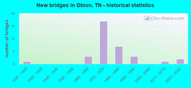
- New bridges - historical statistics
- 11920-1929
- 31960-1969
- 171970-1979
- 71980-1989
- 31990-1999
- 12010-2019
- 22020-2022


- Bridge Condition - Deck
- 12.0%Very good
- 52.0%Good
- 32.0%Satisfactory
- 4.0%Poor

- Bridge Condition - Superstructure
- 16.0%Very good
- 48.0%Good
- 32.0%Satisfactory
- 4.0%Poor

- Bridge Condition - Substructure
- 64.0%Good
- 28.0%Satisfactory
- 8.0%Fair

- Bridge Condition - Channel
- 28.6%Good
- 67.9%Satisfactory
- 3.6%Fair

- Bridge Condition - Culverts
- 83.3%Satisfactory
- 16.7%Fair
Find on map >> Show street view
Structure Number: 66002560013, Location: .2 MILE WEST OF OBION (Lat: 36.262028, Lng: -89.213222), Route carried "on" structure: State highway 183, Year Built: 1980, Status: Open, Structure Length: 4.57m (14.99ft), Average Daily Traffic: 1,924 (year 2020), Truck Traffic: 4%, Average Future Daily Traffic: 3,078 (year 2041), Design Load: HS 20, Features Intersected: RICHLAND CREEK
Minimum Vertical Clearance: 30+ m (98+ ft), Kilometerpoint: 13.116, Lanes on structure: 2, Owner: State Highway Agency, Approaching Roadway Width: 13.4m (44.0ft), Material/Design: Prestressed concrete continuous, Design/Construction: Stringer/Multi-beam, Number Of Spans In Main Unit: 3, Length of Maximum Span: 15.2m (49.9ft), Curb-To-Curb Width: 14.6m (47.9ft), Out-to-Out Width: 15.2m (49.9ft)
Condition: Deck: Satisfactory, Superstructure: Good, Substructure: Satisfactory, Channel: Satisfactory, Operating Rating: 57.6 metric tons, Method Used To Determine Operating Rating: Load Factor (LF), Inventory Rating: 32.4 metric tons, Method Used To Determine Inventory Rating: Load Factor (LF), Structural Evaluation: Equal to present minimum criteria, Deck Geometry: Superior to present desirable criteria, Waterway Adequacy: Somewhat better than minimum adequacy, Approach Roadway Alignment: Equal to present desirable criteria, Designated Inspection Frequency: Every 24 months, Inspection Date: March 2021, Deck Structure Type: Concrete Cast-file-Place, Wearing Surface/Protective System: Wearing Surface: Bituminous
Find on map >> Show street view
Structure Number: 66015230001, Location: 1.5 MI NW JCT SR3&SR183 (Lat: 36.279806, Lng: -89.232250), Route carried "on" structure: County highway 1523, Year Built: 1996, Status: Open, Structure Length: 3.35m (10.99ft), Average Daily Traffic: 197 (year 2020), Truck Traffic: 4%, Average Future Daily Traffic: 352 (year 2041), Design Load: HS 20, Features Intersected: RICHLAND CREEK
Minimum Vertical Clearance: 30+ m (98+ ft), Kilometerpoint: 1.770, Lanes on structure: 2, Owner: County Highway Agency, Approaching Roadway Width: 8.5m (27.9ft), Material/Design: Prestressed concrete continuous, Design/Construction: Box Beam or Girders - Single/Spread, Number Of Spans In Main Unit: 3, Length of Maximum Span: 12.2m (40.0ft), Curb-To-Curb Width: 7.3m (24.0ft), Out-to-Out Width: 8.0m (26.2ft)
Condition: Deck: Good, Superstructure: Very good, Substructure: Good, Channel: Satisfactory, Operating Rating: 84.6 metric tons, Method Used To Determine Operating Rating: Load Factor (LF), Inventory Rating: 32.4 metric tons, Method Used To Determine Inventory Rating: Load Factor (LF), Structural Evaluation: Better than present minimum criteria, Deck Geometry: Somewhat better than minimum adequacy, Waterway Adequacy: Equal to present desirable criteria, Approach Roadway Alignment: Equal to present desirable criteria, Designated Inspection Frequency: Every 24 months, Inspection Date: March 2021, Deck Structure Type: Concrete Precast Panels, Wearing Surface/Protective System: Wearing Surface: Monolithic Concrete, Deck Protection: Epoxy Coated Reinforcing
Find on map >> Show street view
Structure Number: 66015240001, Location: 1.6 MI NE JCT SR183&SR211 (Lat: 36.272472, Lng: -89.168583), Route carried "on" structure: County highway 1524, Year Built: 2021, Status: Open, Structure Length: 2.74m (8.99ft), Average Daily Traffic: 341 (year 2020), Truck Traffic: 3%, Average Future Daily Traffic: 546 (year 2041), Design Load: H 15, Features Intersected: MILL CREEK
Minimum Vertical Clearance: 30+ m (98+ ft), Kilometerpoint: 1.980, Lanes on structure: 2, Owner: County Highway Agency, Approaching Roadway Width: 7.3m (24.0ft), Material/Design: Concrete, Design/Construction: Box Beam or Girders - Multiple, Number Of Spans In Main Unit: 1, Length of Maximum Span: 27.4m (89.9ft), Curb-To-Curb Width: 7.9m (25.9ft), Out-to-Out Width: 8.7m (28.5ft)
Condition: Deck: Good, Superstructure: Good, Substructure: Good, Channel: Satisfactory, Operating Rating: 54.1 metric tons, Method Used To Determine Operating Rating: Field evaluation and documented engineering judgment, Inventory Rating: 32.4 metric tons, Method Used To Determine Inventory Rating: Field evaluation and documented engineering judgment, Structural Evaluation: Better than present minimum criteria, Deck Geometry: Somewhat better than minimum adequacy, Waterway Adequacy: Better than present minimum criteria, Approach Roadway Alignment: Equal to present desirable criteria, Designated Inspection Frequency: Every 24 months, Inspection Date: March 2021, Deck Structure Type: Concrete Cast-file-Place
Find on map >> Show street view
Structure Number: 66015240003, Location: 1.8 MI NE JCT SR183&SR211 (Lat: 36.274611, Lng: -89.165278), Route carried "on" structure: County highway 1524, Year Built: 1965, Status: Open, Structure Length: 1.49m (4.89ft), Average Daily Traffic: 341 (year 2020), Truck Traffic: 3%, Average Future Daily Traffic: 546 (year 2041), Design Load: H 15, Features Intersected: BRANCH
Minimum Vertical Clearance: 30+ m (98+ ft), Kilometerpoint: 2.350, Lanes on structure: 2, Owner: County Highway Agency, Approaching Roadway Width: 7.3m (24.0ft), Material/Design: Concrete, Design/Construction: Channel Beam, Number Of Spans In Main Unit: 3, Length of Maximum Span: 5.8m (19.0ft), Curb-To-Curb Width: 7.2m (23.6ft), Out-to-Out Width: 7.5m (24.6ft)
Condition: Deck: Satisfactory, Superstructure: Satisfactory, Substructure: Satisfactory, Channel: Satisfactory, Operating Rating: 39.6 metric tons, Method Used To Determine Operating Rating: Load Factor (LF), Inventory Rating: 23.4 metric tons, Method Used To Determine Inventory Rating: Load Factor (LF), Structural Evaluation: Equal to present minimum criteria, Deck Geometry: Meets minimum limits, Waterway Adequacy: Equal to present minimum criteria, Approach Roadway Alignment: Equal to present desirable criteria, Length Of Structure Improvement: 1.49m (4.89ft), Designated Inspection Frequency: Every 24 months, Inspection Date: March 2021, Bridge Improvement Cost: $85,000, Roadway Improvement Cost: $9,000, Total Project Cost: $128,000 ( Estimate for 2021), Deck Structure Type: Concrete Precast Panels, Wearing Surface/Protective System: Wearing Surface: Bituminous
Find on map >> Show street view
Structure Number: 66015240005, Location: 3.3 MI NE JCT SR183&SR211 (Lat: 36.278778, Lng: -89.138139), Route carried "on" structure: County highway 1524, Year Built: 1965, Status: Posted for load, Structure Length: 1.01m (3.31ft), Average Daily Traffic: 341 (year 2020), Truck Traffic: 3%, Average Future Daily Traffic: 736 (year 2041), Design Load: H 15, Features Intersected: DRY CREEK
Minimum Vertical Clearance: 30+ m (98+ ft), Kilometerpoint: 5.150, Lanes on structure: 2, Owner: County Highway Agency, Approaching Roadway Width: 7.3m (24.0ft), Material/Design: Concrete, Design/Construction: Tee Beam, Number Of Spans In Main Unit: 1, Length of Maximum Span: 9.8m (32.2ft), Curb-To-Curb Width: 7.1m (23.3ft), Out-to-Out Width: 7.5m (24.6ft)
Condition: Deck: Satisfactory, Superstructure: Good, Substructure: Satisfactory, Channel: Satisfactory, Operating Rating: 36.0 metric tons, Method Used To Determine Operating Rating: Field evaluation and documented engineering judgment, Inventory Rating: 24.3 metric tons, Method Used To Determine Inventory Rating: Field evaluation and documented engineering judgment, Structural Evaluation: Equal to present minimum criteria, Deck Geometry: Meets minimum limits, Waterway Adequacy: Equal to present minimum criteria, Approach Roadway Alignment: Equal to present desirable criteria, Length Of Structure Improvement: 1.01m (3.31ft), Designated Inspection Frequency: Every 24 months, Inspection Date: March 2021, Bridge Improvement Cost: $80,000, Roadway Improvement Cost: $9,000, Total Project Cost: $121,000 ( Estimate for 2021), Deck Structure Type: Concrete Cast-file-Place, Wearing Surface/Protective System: Wearing Surface: Bituminous
Find on map >> Show street view
Structure Number: 66015260001, Location: 3.7 MI SE JCT SR21&SR183 (Lat: 36.298111, Lng: -89.247028), Route carried "on" structure: County highway 1526, Year Built: 1970, Year Reconstructed: 2011, Status: Posted for load, Structure Length: 1.37m (4.49ft), Average Daily Traffic: 107 (year 2020), Truck Traffic: 4%, Average Future Daily Traffic: 171 (year 2042), Design Load: H 15, Features Intersected: RICHLAND CREEK
Minimum Vertical Clearance: 30+ m (98+ ft), Kilometerpoint: 2.849, Lanes on structure: 2, Owner: County Highway Agency, Approaching Roadway Width: 7.3m (24.0ft), Material/Design: Prestressed concrete, Design/Construction: Box Beam or Girders - Multiple, Number Of Spans In Main Unit: 1, Length of Maximum Span: 13.4m (44.0ft), Curb-To-Curb Width: 7.1m (23.3ft), Out-to-Out Width: 7.3m (24.0ft)
Condition: Deck: Very good, Superstructure: Very good, Substructure: Good, Channel: Satisfactory, Operating Rating: 36.0 metric tons, Method Used To Determine Operating Rating: Field evaluation and documented engineering judgment, Inventory Rating: 24.3 metric tons, Method Used To Determine Inventory Rating: Field evaluation and documented engineering judgment, Structural Evaluation: Equal to present minimum criteria, Deck Geometry: Meets minimum limits, Waterway Adequacy: Equal to present minimum criteria, Approach Roadway Alignment: Equal to present desirable criteria, Designated Inspection Frequency: Every 24 months, Inspection Date: March 2021, Deck Structure Type: Other, Wearing Surface/Protective System: Wearing Surface: Bituminous
Find on map >> Show street view
Structure Number: 66015260003, Location: 4.3 MI SE JCT SR21&SR183 (Lat: 36.307306, Lng: -89.225583), Route carried "on" structure: County highway 1526, Year Built: 1984, Status: Open, Structure Length: 1.13m (3.71ft), Average Daily Traffic: 763 (year 2020), Truck Traffic: 3%, Average Future Daily Traffic: 1,040 (year 2041), Design Load: HS 20, Features Intersected: LITTLE RICHLAND CREEK
Minimum Vertical Clearance: 30+ m (98+ ft), Kilometerpoint: 5.150, Lanes on structure: 2, Owner: County Highway Agency, Approaching Roadway Width: 7.9m (25.9ft), Skew: 4 degrees, Material/Design: Concrete continuous, Design/Construction: Culvert, Number Of Spans In Main Unit: 2, Length of Maximum Span: 3.7m (12.1ft), Curb-To-Curb Width: 6.8m (22.3ft), Out-to-Out Width: 7.8m (25.6ft)
Condition: Channel: Satisfactory, Culverts: Satisfactory, Operating Rating: 89.1 metric tons, Method Used To Determine Operating Rating: Load Factor (LF), Inventory Rating: 32.4 metric tons, Method Used To Determine Inventory Rating: Load Factor (LF), Structural Evaluation: Equal to present minimum criteria, Deck Geometry: Meets minimum limits, Waterway Adequacy: Equal to present desirable criteria, Approach Roadway Alignment: Equal to present minimum criteria, Designated Inspection Frequency: Every 24 months, Inspection Date: March 2021, Deck Structure Type: Concrete Cast-file-Place, Wearing Surface/Protective System: Wearing Surface: Bituminous
Find on map >> Show street view
Structure Number: 660A5900003, Location: 2.2 MI NE JCT SR183&SR211 (Lat: 36.284778, Lng: -89.169028), Route carried "on" structure: County highway 590, Year Built: 1992, Status: Open, Structure Length: 2.53m (8.30ft), Average Daily Traffic: 60 (year 2022), Truck Traffic: 4%, Average Future Daily Traffic: 96 (year 2041), Design Load: HS 20, Features Intersected: MILL CREEK
Minimum Vertical Clearance: 30+ m (98+ ft), Kilometerpoint: 5.856, Lanes on structure: 2, Owner: County Highway Agency, Approaching Roadway Width: 7.9m (25.9ft), Material/Design: Prestressed concrete, Design/Construction: Stringer/Multi-beam, Number Of Spans In Main Unit: 3, Length of Maximum Span: 12.5m (41.0ft), Curb-To-Curb Width: 6.7m (22.0ft), Out-to-Out Width: 7.3m (24.0ft)
Condition: Deck: Very good, Superstructure: Good, Substructure: Satisfactory, Channel: Satisfactory, Operating Rating: 44.1 metric tons, Method Used To Determine Operating Rating: Assigned rating based on Load Factor Design (LFD) reported in metric tons, Inventory Rating: 32.4 metric tons, Method Used To Determine Inventory Rating: Assigned rating based on Load Factor Design (LFD) reported in metric tons, Structural Evaluation: Equal to present minimum criteria, Deck Geometry: Somewhat better than minimum adequacy, Waterway Adequacy: Equal to present minimum criteria, Approach Roadway Alignment: Equal to present desirable criteria, Designated Inspection Frequency: Every 24 months, Inspection Date: March 2021, Deck Structure Type: Concrete Precast Panels, Wearing Surface/Protective System: Wearing Surface: Monolithic Concrete
Find on map >> Show street view
Structure Number: 660A6170001, Location: CLINT WORD ROAD (Lat: 36.312750, Lng: -89.225389), Route carried "on" structure: County highway 617, Year Built: 2017, Status: Open, Structure Length: 1.53m (5.02ft), Average Daily Traffic: 360 (year 2022), Truck Traffic: 4%, Average Future Daily Traffic: 576 (year 2041), Design Load: HL 93, Features Intersected: LITTLE RICHLAND CREEK
Minimum Vertical Clearance: 30+ m (98+ ft), Kilometerpoint: 2.681, Lanes on structure: 2, Owner: County Highway Agency, Approaching Roadway Width: 8.5m (27.9ft), Skew: 1 degrees, Material/Design: Concrete, Design/Construction: Stringer/Multi-beam, Number Of Spans In Main Unit: 1, Length of Maximum Span: 15.3m (50.2ft), Curb-To-Curb Width: 7.3m (24.0ft), Out-to-Out Width: 7.9m (25.9ft)
Condition: Deck: Good, Superstructure: Very good, Substructure: Good, Channel: Good, Operating Rating: 44.1 metric tons, Method Used To Determine Operating Rating: Assigned ratings based on Load and Resistance Factor Design (LRFD) reported by rating factor (RF) using HL93 loadings, Inventory Rating: 32.4 metric tons, Method Used To Determine Inventory Rating: Assigned ratings based on Load and Resistance Factor Design (LRFD) reported by rating factor (RF) using HL93 loadings, Structural Evaluation: Better than present minimum criteria, Deck Geometry: Somewhat better than minimum adequacy, Waterway Adequacy: Equal to present desirable criteria, Approach Roadway Alignment: Equal to present desirable criteria, Designated Inspection Frequency: Every 24 months, Inspection Date: March 2021, Deck Structure Type: Concrete Cast-file-Place, Wearing Surface/Protective System: Wearing Surface: Monolithic Concrete
Find on map >> Show street view
Structure Number: 660A6180001, Location: 2.7 MI NW JCT SR183&SR211 (Lat: 36.292194, Lng: -89.216194), Route carried "on" structure: County highway 618, Year Built: 1960, Year Reconstructed: 2012, Status: Open, Structure Length: 0.87m (2.85ft), Average Daily Traffic: 40 (year 2022), Truck Traffic: 4%, Average Future Daily Traffic: 64 (year 2041), Design Load: H 15, Features Intersected: RICHLAND CREEK
Minimum Vertical Clearance: 30+ m (98+ ft), Kilometerpoint: 0.124, Lanes on structure: 2, Owner: County Highway Agency, Approaching Roadway Width: 7.3m (24.0ft), Material/Design: Concrete, Design/Construction: Channel Beam, Number Of Spans In Main Unit: 1, Length of Maximum Span: 8.7m (28.5ft), Curb-To-Curb Width: 7.3m (24.0ft), Out-to-Out Width: 7.8m (25.6ft)
Condition: Deck: Good, Superstructure: Satisfactory, Substructure: Good, Channel: Satisfactory, Operating Rating: 33.3 metric tons, Method Used To Determine Operating Rating: Load Factor (LF), Inventory Rating: 19.8 metric tons, Method Used To Determine Inventory Rating: Load Factor (LF), Structural Evaluation: Somewhat better than minimum adequacy, Deck Geometry: Equal to present minimum criteria, Waterway Adequacy: Equal to present desirable criteria, Approach Roadway Alignment: Equal to present desirable criteria, Designated Inspection Frequency: Every 24 months, Inspection Date: March 2021, Deck Structure Type: Concrete Precast Panels, Wearing Surface/Protective System: Wearing Surface: Bituminous
Find on map >> Show street view
Structure Number: 660A6190001, Location: 1.7 MI NW JCT SR183&SR211 (Lat: 36.281278, Lng: -89.207472), Route carried "on" structure: County highway 619, Year Built: 1975, Status: Open, Structure Length: 0.67m (2.20ft), Average Daily Traffic: 70 (year 2022), Truck Traffic: 5%, Average Future Daily Traffic: 112 (year 2041), Design Load: HS 20, Features Intersected: BRANCH
Minimum Vertical Clearance: 30+ m (98+ ft), Kilometerpoint: 1.677, Lanes on structure: 2, Owner: County Highway Agency, Approaching Roadway Width: 9.8m (32.2ft), Skew: 1 degrees, Material/Design: Concrete continuous, Design/Construction: Culvert, Number Of Spans In Main Unit: 2, Length of Maximum Span: 3.0m (9.8ft)
Condition: Channel: Satisfactory, Culverts: Satisfactory, Operating Rating: 89.1 metric tons, Method Used To Determine Operating Rating: Load Factor (LF), Inventory Rating: 32.4 metric tons, Method Used To Determine Inventory Rating: Load Factor (LF), Structural Evaluation: Equal to present minimum criteria, Waterway Adequacy: Equal to present desirable criteria, Approach Roadway Alignment: Equal to present desirable criteria, Designated Inspection Frequency: Every 24 months, Inspection Date: March 2021
Find on map >> Show street view
Structure Number: 660A6590001, Location: 4.3 MI SW JCT SR183&SR211 (Lat: 36.245222, Lng: -89.263611), Route carried "on" structure: County highway 659, Year Built: 1975, Year Reconstructed: 2000, Status: Open, Structure Length: 0.88m (2.89ft), Average Daily Traffic: 140 (year 2022), Truck Traffic: 4%, Average Future Daily Traffic: 224 (year 2041), Design Load: H 15, Features Intersected: BRANCH
Minimum Vertical Clearance: 30+ m (98+ ft), Kilometerpoint: 2.268, Lanes on structure: 2, Owner: County Highway Agency, Approaching Roadway Width: 6.7m (22.0ft), Skew: 1 degrees, Material/Design: Concrete, Design/Construction: Channel Beam, Number Of Spans In Main Unit: 1, Length of Maximum Span: 8.5m (27.9ft), Curb-To-Curb Width: 7.3m (24.0ft), Out-to-Out Width: 7.8m (25.6ft)
Condition: Deck: Good, Superstructure: Satisfactory, Substructure: Good, Channel: Satisfactory, Operating Rating: 29.7 metric tons, Method Used To Determine Operating Rating: Load Factor (LF), Inventory Rating: 18.0 metric tons, Method Used To Determine Inventory Rating: Load Factor (LF), Structural Evaluation: Somewhat better than minimum adequacy, Deck Geometry: Somewhat better than minimum adequacy, Waterway Adequacy: Equal to present minimum criteria, Approach Roadway Alignment: Equal to present desirable criteria, Designated Inspection Frequency: Every 24 months, Inspection Date: March 2021, Deck Structure Type: Concrete Precast Panels, Wearing Surface/Protective System: Wearing Surface: Bituminous
Find on map >> Show street view
Structure Number: 660A6610001, Location: 4.3 MI NW JCT SR105&SR211 (Lat: 36.256361, Lng: -89.230306), Route carried "on" structure: County highway 661, Year Built: 1984, Status: Open, Structure Length: 1.13m (3.71ft), Average Daily Traffic: 40 (year 2022), Truck Traffic: 4%, Average Future Daily Traffic: 64 (year 2041), Design Load: HS 20, Features Intersected: BRANCH
Minimum Vertical Clearance: 30+ m (98+ ft), Kilometerpoint: 1.125, Lanes on structure: 2, Owner: County Highway Agency, Approaching Roadway Width: 6.7m (22.0ft), Material/Design: Concrete continuous, Design/Construction: Culvert, Number Of Spans In Main Unit: 2, Length of Maximum Span: 4.6m (15.1ft), Curb-To-Curb Width: 6.7m (22.0ft), Out-to-Out Width: 7.8m (25.6ft)
Condition: Channel: Satisfactory, Culverts: Satisfactory, Operating Rating: 81.9 metric tons, Method Used To Determine Operating Rating: Load Factor (LF), Inventory Rating: 32.4 metric tons, Method Used To Determine Inventory Rating: Load Factor (LF), Structural Evaluation: Equal to present minimum criteria, Deck Geometry: Somewhat better than minimum adequacy, Waterway Adequacy: Equal to present minimum criteria, Approach Roadway Alignment: Equal to present minimum criteria, Designated Inspection Frequency: Every 24 months, Inspection Date: March 2021, Deck Structure Type: Concrete Cast-file-Place, Wearing Surface/Protective System: Wearing Surface: Gravel
Find on map >> Show street view
Structure Number: 660A6610003, Location: 4.1 MI NW JCT SR105&SR211 (Lat: 36.245083, Lng: -89.249639), Route carried "on" structure: County highway 661, Year Built: 1983, Status: Open, Structure Length: 0.67m (2.20ft), Average Daily Traffic: 40 (year 2022), Truck Traffic: 4%, Average Future Daily Traffic: 64 (year 2041), Design Load: HS 20, Features Intersected: BURNT MILL HOLLOW CREEK
Minimum Vertical Clearance: 30+ m (98+ ft), Kilometerpoint: 4.233, Lanes on structure: 2, Owner: County Highway Agency, Approaching Roadway Width: 6.7m (22.0ft), Material/Design: Concrete continuous, Design/Construction: Culvert, Number Of Spans In Main Unit: 2, Length of Maximum Span: 3.0m (9.8ft), Curb-To-Curb Width: 6.7m (22.0ft), Out-to-Out Width: 7.8m (25.6ft)
Condition: Channel: Fair, Culverts: Satisfactory, Operating Rating: 89.1 metric tons, Method Used To Determine Operating Rating: Load Factor (LF), Inventory Rating: 32.4 metric tons, Method Used To Determine Inventory Rating: Load Factor (LF), Structural Evaluation: Equal to present minimum criteria, Deck Geometry: Somewhat better than minimum adequacy, Waterway Adequacy: Equal to present minimum criteria, Approach Roadway Alignment: Equal to present desirable criteria, Designated Inspection Frequency: Every 24 months, Inspection Date: March 2021, Deck Structure Type: Concrete Cast-file-Place, Wearing Surface/Protective System: Wearing Surface: Gravel
Find on map >> Show street view
Structure Number: 660A8100003, Location: IN WATERFOWL MNGMT AREA (Lat: 36.264944, Lng: -89.117056), Route carried "on" structure: County highway 2122, Year Built: 1989, Status: Posted for load, Structure Length: 2.56m (8.40ft), Average Daily Traffic: 227 (year 2020), Truck Traffic: 3%, Average Future Daily Traffic: 400 (year 2041), Design Load: H 15, Features Intersected: OVERFLOW (GWMA)
Minimum Vertical Clearance: 30+ m (98+ ft), Kilometerpoint: 7.113, Lanes on structure: 2, Owner: County Highway Agency, Approaching Roadway Width: 9.1m (29.9ft), Material/Design: Concrete, Design/Construction: Box Beam or Girders - Multiple, Number Of Spans In Main Unit: 3, Length of Maximum Span: 13.7m (44.9ft), Curb-To-Curb Width: 6.2m (20.3ft), Out-to-Out Width: 6.5m (21.3ft)
Condition: Deck: Satisfactory, Superstructure: Satisfactory, Substructure: Fair, Channel: Good, Operating Rating: 36.0 metric tons, Method Used To Determine Operating Rating: Field evaluation and documented engineering judgment, Inventory Rating: 24.3 metric tons, Method Used To Determine Inventory Rating: Field evaluation and documented engineering judgment, Structural Evaluation: Somewhat better than minimum adequacy, Deck Geometry: Meets minimum limits, Waterway Adequacy: Equal to present minimum criteria, Approach Roadway Alignment: Equal to present desirable criteria, Length Of Structure Improvement: 3.45m (11.32ft), Designated Inspection Frequency: Every 24 months, Inspection Date: March 2021, Bridge Improvement Cost: $677,000, Roadway Improvement Cost: $68,000, Total Project Cost: $1,016,000 ( Estimate for 2021), Deck Structure Type: Other, Wearing Surface/Protective System: Wearing Surface: Bituminous
Find on map >> Show street view
Structure Number: 660B1000005, Location: 1.9 MI N OF DYER COUNTY (Lat: 36.233083, Lng: -89.194583), Route carried "on" structure: County highway 100, Year Built: 1928, Status: Posted for load, Structure Length: 35.63m (116.90ft), Average Daily Traffic: 1,380 (year 2022), Truck Traffic: 4%, Average Future Daily Traffic: 2,208 (year 2041), Design Load: HS 15, Features Intersected: OVERFLOW
Minimum Vertical Clearance: 30+ m (98+ ft), Kilometerpoint: 3.063, Lanes on structure: 2, Owner: County Highway Agency, Approaching Roadway Width: 9.1m (29.9ft), Material/Design: Concrete, Design/Construction: Tee Beam, Number Of Spans In Main Unit: 41, Length of Maximum Span: 8.8m (28.9ft), Curb-To-Curb Width: 6.1m (20.0ft), Out-to-Out Width: 7.1m (23.3ft)
Condition: Deck: Poor, Superstructure: Poor, Substructure: Fair, Channel: Good, Operating Rating: 9.0 metric tons, Method Used To Determine Operating Rating: Load Factor (LF), Inventory Rating: 5.4 metric tons, Method Used To Determine Inventory Rating: Load Factor (LF), Structural Evaluation: High priority of replacement, Deck Geometry: High priority of replacement, Waterway Adequacy: Equal to present desirable criteria, Approach Roadway Alignment: Equal to present desirable criteria, Bridge Posting: Required (Relationship of Operating Rating to Maximum Legal Load: 10.0 - 19.9% below), Length Of Structure Improvement: 35.63m (116.90ft), Designated Inspection Frequency: Every 24 months, Inspection Date: March 2021, Bridge Improvement Cost: $6,996,000, Roadway Improvement Cost: $700,000, Total Project Cost: $10,495,000 ( Estimate for 2021), Deck Structure Type: Concrete Cast-file-Place, Wearing Surface/Protective System: Wearing Surface: Bituminous
Find on map >> Show street view
Structure Number: 66F00250003, Location: 5.3 MI N OF GIBSON CO. (Lat: 36.274722, Lng: -89.122972), Route carried "on" structure: County highway 2122, Year Built: 2021, Status: Closed, Structure Length: 2.74m (8.99ft), Average Daily Traffic: 227 (year 2020), Truck Traffic: 3%, Average Future Daily Traffic: 363 (year 2042), Design Load: HL 93, Features Intersected: OLD OBION RIVER BED
Minimum Vertical Clearance: 30+ m (98+ ft), Kilometerpoint: 8.353, Lanes on structure: 2, Owner: County Highway Agency, Approaching Roadway Width: 7.9m (25.9ft), Material/Design: Prestressed concrete, Design/Construction: Box Beam or Girders - Single/Spread, Number Of Spans In Main Unit: 1, Length of Maximum Span: 27.4m (89.9ft), Curb-To-Curb Width: 7.9m (25.9ft), Out-to-Out Width: 8.7m (28.5ft)
Condition: Deck: Good, Superstructure: Good, Substructure: Good, Channel: Good, Operating Rating: 42.4 metric tons, Method Used To Determine Operating Rating: Field evaluation and documented engineering judgment, Inventory Rating: 32.4 metric tons, Method Used To Determine Inventory Rating: Field evaluation and documented engineering judgment, Structural Evaluation: Better than present minimum criteria, Deck Geometry: Somewhat better than minimum adequacy, Waterway Adequacy: Equal to present minimum criteria, Approach Roadway Alignment: Equal to present desirable criteria, Length Of Structure Improvement: 3.66m (12.01ft), Designated Inspection Frequency: Every 24 months, Inspection Date: March 2021, Bridge Improvement Cost: $798,000, Roadway Improvement Cost: $80,000, Total Project Cost: $1,198,000 ( Estimate for 2022), Deck Structure Type: Concrete Cast-file-Place, Wearing Surface/Protective System: Wearing Surface: Monolithic Concrete
Find on map >> Show street view
Structure Number: 66F00250005, Location: 4.9 MI N OF GIBSON CO. (Lat: 36.268972, Lng: -89.119694), Route carried "on" structure: County highway 2122, Year Built: 1990, Status: Open, Structure Length: 8.35m (27.40ft), Average Daily Traffic: 227 (year 2020), Truck Traffic: 3%, Average Future Daily Traffic: 400 (year 2041), Design Load: HS 20, Features Intersected: OBION RIVER
Minimum Vertical Clearance: 30+ m (98+ ft), Kilometerpoint: 7.596, Lanes on structure: 2, Owner: County Highway Agency, Approaching Roadway Width: 6.7m (22.0ft), Skew: 2 degrees, Material/Design: Prestressed concrete, Design/Construction: Stringer/Multi-beam, Number Of Spans In Main Unit: 3, Length of Maximum Span: 29.6m (97.1ft), Curb-To-Curb Width: 6.7m (22.0ft), Out-to-Out Width: 7.3m (24.0ft)
Condition: Deck: Good, Superstructure: Satisfactory, Substructure: Good, Channel: Satisfactory, Operating Rating: 60.8 metric tons, Method Used To Determine Operating Rating: Load Factor (LF), Inventory Rating: 32.4 metric tons, Method Used To Determine Inventory Rating: Load Factor (LF), Structural Evaluation: Equal to present minimum criteria, Deck Geometry: Meets minimum limits, Waterway Adequacy: Equal to present desirable criteria, Approach Roadway Alignment: Equal to present desirable criteria, Designated Inspection Frequency: Every 24 months, Underwater Inspection Frequency: Every 60 months, Inspection Date: April 2021, Underwater Inspection Date: August 2020, Deck Structure Type: Concrete Precast Panels, Wearing Surface/Protective System: Wearing Surface: Monolithic Concrete, Deck Protection: Epoxy Coated Reinforcing
Find on map >> Show street view
Structure Number: 66S80050009, Location: 1.6 MI.WEST OF OBION (Lat: 36.264611, Lng: -89.257167), Route carried "on" structure: State highway 183, Year Built: 1980, Status: Open, Structure Length: 0.67m (2.20ft), Average Daily Traffic: 1,906 (year 2020), Truck Traffic: 4%, Average Future Daily Traffic: 2,784 (year 2039), Design Load: HS 20, Features Intersected: BURNT MILL HOLLOW CREEK
Minimum Vertical Clearance: 30+ m (98+ ft), Kilometerpoint: 9.141, Lanes on structure: 2, Owner: State Highway Agency, Approaching Roadway Width: 13.4m (44.0ft), Material/Design: Concrete continuous, Design/Construction: Culvert, Number Of Spans In Main Unit: 2, Length of Maximum Span: 3.0m (9.8ft)
Condition: Channel: Satisfactory, Culverts: Satisfactory, Operating Rating: 54.0 metric tons, Method Used To Determine Operating Rating: Field evaluation and documented engineering judgment, Inventory Rating: 32.4 metric tons, Method Used To Determine Inventory Rating: Field evaluation and documented engineering judgment, Structural Evaluation: Equal to present minimum criteria, Waterway Adequacy: Equal to present desirable criteria, Approach Roadway Alignment: Equal to present desirable criteria, Designated Inspection Frequency: Every 24 months, Inspection Date: March 2021
Find on map >> Show street view
Structure Number: 66S80060001, Location: 4 MI.SOUTH OF HORNBEAK (Lat: 36.274667, Lng: -89.264778), Route carried "on" structure: State highway 183, Year Built: 1986, Status: Open, Structure Length: 1.01m (3.31ft), Average Daily Traffic: 965 (year 2020), Truck Traffic: 4%, Average Future Daily Traffic: 1,544 (year 2041), Design Load: HS 20, Features Intersected: BURNT MILL HOLLOW BRANCH
Minimum Vertical Clearance: 30+ m (98+ ft), Kilometerpoint: 7.258, Lanes on structure: 2, Owner: State Highway Agency, Approaching Roadway Width: 7.9m (25.9ft), Material/Design: Concrete continuous, Design/Construction: Culvert, Number Of Spans In Main Unit: 2, Length of Maximum Span: 4.6m (15.1ft)
Condition: Channel: Satisfactory, Culverts: Fair, Operating Rating: 54.0 metric tons, Method Used To Determine Operating Rating: Field evaluation and documented engineering judgment, Inventory Rating: 32.4 metric tons, Method Used To Determine Inventory Rating: Field evaluation and documented engineering judgment, Structural Evaluation: Somewhat better than minimum adequacy, Waterway Adequacy: Equal to present desirable criteria, Approach Roadway Alignment: Equal to present desirable criteria, Designated Inspection Frequency: Every 24 months, Inspection Date: March 2021
Find on map >> Show street view
Structure Number: 66SR0030025, Location: 0.75 MI N OF DYER COUNTY (Lat: 36.225889, Lng: -89.211889), Route carried "on" structure: US 51, Year Built: 1978, Status: Open, Structure Length: 11.58m (37.99ft), Average Daily Traffic: 10,621 (year 2020), Truck Traffic: 11%, Average Future Daily Traffic: 17,712 (year 2039), Design Load: HS 20, Features Intersected: OVERFLOW, Facility Carried by Structure: FAP 3
Minimum Vertical Clearance: 30+ m (98+ ft), Kilometerpoint: 2.205, Lanes on structure: 2, Base Highway Network: Yes, Owner: State Highway Agency, Approaching Roadway Width: 23.2m (76.1ft), Material/Design: Prestressed concrete, Design/Construction: Stringer/Multi-beam, Number Of Spans In Main Unit: 5, Length of Maximum Span: 23.2m (76.1ft), Curb-To-Curb Width: 12.8m (42.0ft), Out-to-Out Width: 13.4m (44.0ft)
Condition: Deck: Satisfactory, Superstructure: Satisfactory, Substructure: Good, Channel: Good, Operating Rating: 57.6 metric tons, Method Used To Determine Operating Rating: Load Factor (LF), Inventory Rating: 32.4 metric tons, Method Used To Determine Inventory Rating: Load Factor (LF), Structural Evaluation: Equal to present minimum criteria, Deck Geometry: Somewhat better than minimum adequacy, Waterway Adequacy: Equal to present desirable criteria, Approach Roadway Alignment: Equal to present desirable criteria, Designated Inspection Frequency: Every 24 months, Inspection Date: March 2021, Deck Structure Type: Concrete Cast-file-Place, Wearing Surface/Protective System: Wearing Surface: Bituminous
Find on map >> Show street view
Structure Number: 66SR0030026, Location: 0.75 MI N OF DYER COUNTY (Lat: 36.225722, Lng: -89.212167), Route carried "on" structure: US 51, Year Built: 1978, Status: Open, Structure Length: 11.58m (37.99ft), Average Daily Traffic: 10,621 (year 2020), Truck Traffic: 11%, Average Future Daily Traffic: 16,994 (year 2041), Design Load: HS 20, Features Intersected: OVERFLOW, Facility Carried by Structure: FAP 3
Minimum Vertical Clearance: 30+ m (98+ ft), Kilometerpoint: 2.205, Lanes on structure: 2, Base Highway Network: Yes, Owner: State Highway Agency, Approaching Roadway Width: 23.2m (76.1ft), Material/Design: Prestressed concrete, Design/Construction: Stringer/Multi-beam, Number Of Spans In Main Unit: 5, Length of Maximum Span: 23.2m (76.1ft), Curb-To-Curb Width: 12.8m (42.0ft), Out-to-Out Width: 13.4m (44.0ft)
Condition: Deck: Good, Superstructure: Satisfactory, Substructure: Satisfactory, Channel: Good, Operating Rating: 57.6 metric tons, Method Used To Determine Operating Rating: Load Factor (LF), Inventory Rating: 32.4 metric tons, Method Used To Determine Inventory Rating: Load Factor (LF), Structural Evaluation: Equal to present minimum criteria, Deck Geometry: Somewhat better than minimum adequacy, Waterway Adequacy: Equal to present desirable criteria, Approach Roadway Alignment: Equal to present desirable criteria, Designated Inspection Frequency: Every 24 months, Inspection Date: March 2021, Deck Structure Type: Concrete Cast-file-Place, Wearing Surface/Protective System: Wearing Surface: Bituminous
Find on map >> Show street view
Structure Number: 66SR0030027, Location: 2 MI N OF DYER COUNTY (Lat: 36.238250, Lng: -89.216389), Route carried "on" structure: US 51, Year Built: 1978, Status: Open, Structure Length: 11.58m (37.99ft), Average Daily Traffic: 10,621 (year 2020), Truck Traffic: 11%, Average Future Daily Traffic: 16,994 (year 2041), Design Load: HS 20, Features Intersected: OLD OBION RV DRAIN CAN, Facility Carried by Structure: FAP 3
Minimum Vertical Clearance: 30+ m (98+ ft), Kilometerpoint: 3.637, Lanes on structure: 2, Base Highway Network: Yes, Owner: State Highway Agency, Approaching Roadway Width: 23.2m (76.1ft), Material/Design: Prestressed concrete, Design/Construction: Stringer/Multi-beam, Number Of Spans In Main Unit: 5, Length of Maximum Span: 23.2m (76.1ft), Curb-To-Curb Width: 12.8m (42.0ft), Out-to-Out Width: 13.4m (44.0ft)
Condition: Deck: Good, Superstructure: Good, Substructure: Good, Channel: Good, Operating Rating: 57.6 metric tons, Method Used To Determine Operating Rating: Load Factor (LF), Inventory Rating: 32.4 metric tons, Method Used To Determine Inventory Rating: Load Factor (LF), Structural Evaluation: Better than present minimum criteria, Deck Geometry: Somewhat better than minimum adequacy, Waterway Adequacy: Equal to present desirable criteria, Approach Roadway Alignment: Equal to present desirable criteria, Designated Inspection Frequency: Every 24 months, Inspection Date: March 2021, Deck Structure Type: Concrete Cast-file-Place, Wearing Surface/Protective System: Wearing Surface: Bituminous
Find on map >> Show street view
Structure Number: 66SR0030028, Location: 2 MI N OF DYER COUNTY (Lat: 36.238194, Lng: -89.216667), Route carried "on" structure: US 51, Year Built: 1978, Status: Open, Structure Length: 11.58m (37.99ft), Average Daily Traffic: 10,621 (year 2020), Truck Traffic: 11%, Average Future Daily Traffic: 16,994 (year 2041), Design Load: HS 20, Features Intersected: OLD OBION RV DRAIN CAN, Facility Carried by Structure: FAP 3
Minimum Vertical Clearance: 30+ m (98+ ft), Kilometerpoint: 3.637, Lanes on structure: 2, Base Highway Network: Yes, Owner: State Highway Agency, Approaching Roadway Width: 23.2m (76.1ft), Material/Design: Prestressed concrete continuous, Design/Construction: Stringer/Multi-beam, Number Of Spans In Main Unit: 5, Length of Maximum Span: 23.2m (76.1ft), Curb-To-Curb Width: 12.8m (42.0ft), Out-to-Out Width: 13.4m (44.0ft)
Condition: Deck: Good, Superstructure: Good, Substructure: Good, Channel: Good, Operating Rating: 57.6 metric tons, Method Used To Determine Operating Rating: Load Factor (LF), Inventory Rating: 32.4 metric tons, Method Used To Determine Inventory Rating: Load Factor (LF), Structural Evaluation: Better than present minimum criteria, Deck Geometry: Somewhat better than minimum adequacy, Waterway Adequacy: Equal to present desirable criteria, Approach Roadway Alignment: Equal to present desirable criteria, Designated Inspection Frequency: Every 24 months, Inspection Date: March 2021, Deck Structure Type: Concrete Cast-file-Place, Wearing Surface/Protective System: Wearing Surface: Bituminous
Find on map >> Show street view
Structure Number: 66SR0030029, Location: 2.5 MI N OF DYER COUNTY (Lat: 36.239889, Lng: -89.216917), Route carried "on" structure: US 51, Year Built: 1978, Status: Open, Structure Length: 11.61m (38.09ft), Average Daily Traffic: 10,621 (year 2020), Truck Traffic: 11%, Average Future Daily Traffic: 15,456 (year 2041), Design Load: HS 20, Features Intersected: OBION RIVER, Facility Carried by Structure: FAP 3
Minimum Vertical Clearance: 30+ m (98+ ft), Kilometerpoint: 3.830, Lanes on structure: 2, Base Highway Network: Yes, Owner: State Highway Agency, Approaching Roadway Width: 23.2m (76.1ft), Skew: 11 degrees, Material/Design: Prestressed concrete continuous, Design/Construction: Stringer/Multi-beam, Number Of Spans In Main Unit: 5, Length of Maximum Span: 23.5m (77.1ft), Curb-To-Curb Width: 12.8m (42.0ft), Out-to-Out Width: 13.4m (44.0ft)
Condition: Deck: Good, Superstructure: Good, Substructure: Satisfactory, Channel: Satisfactory, Operating Rating: 55.8 metric tons, Method Used To Determine Operating Rating: Load Factor (LF), Inventory Rating: 32.4 metric tons, Method Used To Determine Inventory Rating: Load Factor (LF), Structural Evaluation: Equal to present minimum criteria, Deck Geometry: Somewhat better than minimum adequacy, Waterway Adequacy: Equal to present desirable criteria, Approach Roadway Alignment: Equal to present desirable criteria, Designated Inspection Frequency: Every 24 months, Inspection Date: March 2021, Deck Structure Type: Concrete Cast-file-Place, Wearing Surface/Protective System: Wearing Surface: Bituminous
Find on map >> Show street view
Structure Number: 66SR003003, Location: 2.5 MI N OF DYER COUNTY (Lat: 36.239889, Lng: -89.217306), Route carried "on" structure: US 51, Year Built: 1978, Status: Open, Structure Length: 11.61m (38.09ft), Average Daily Traffic: 10,621 (year 2020), Truck Traffic: 11%, Average Future Daily Traffic: 15,456 (year 2041), Design Load: HS 20, Features Intersected: OBION RIVER, Facility Carried by Structure: FAP 3
Minimum Vertical Clearance: 30+ m (98+ ft), Kilometerpoint: 3.830, Lanes on structure: 2, Base Highway Network: Yes, Owner: State Highway Agency, Approaching Roadway Width: 23.2m (76.1ft), Skew: 11 degrees, Material/Design: Prestressed concrete continuous, Design/Construction: Stringer/Multi-beam, Number Of Spans In Main Unit: 5, Length of Maximum Span: 23.5m (77.1ft), Curb-To-Curb Width: 12.8m (42.0ft), Out-to-Out Width: 13.4m (44.0ft)
Condition: Deck: Satisfactory, Superstructure: Good, Substructure: Satisfactory, Channel: Satisfactory, Operating Rating: 55.8 metric tons, Method Used To Determine Operating Rating: Load Factor (LF), Inventory Rating: 32.4 metric tons, Method Used To Determine Inventory Rating: Load Factor (LF), Structural Evaluation: Equal to present minimum criteria, Deck Geometry: Somewhat better than minimum adequacy, Waterway Adequacy: Equal to present desirable criteria, Approach Roadway Alignment: Equal to present desirable criteria, Designated Inspection Frequency: Every 24 months, Inspection Date: March 2021, Deck Structure Type: Concrete Cast-file-Place, Wearing Surface/Protective System: Wearing Surface: Bituminous
Find on map >> Show street view
Structure Number: 66SR0030031, Location: 4 MI N OF DYER COUNTY (Lat: 36.266000, Lng: -89.214861), Route carried "on" structure: US 51, Year Built: 1978, Status: Open, Structure Length: 4.57m (14.99ft), Average Daily Traffic: 9,943 (year 2020), Truck Traffic: 11%, Average Future Daily Traffic: 14,608 (year 2041), Design Load: HS 20, Features Intersected: RICHLAND CREEK, Facility Carried by Structure: FAP 3
Minimum Vertical Clearance: 30+ m (98+ ft), Kilometerpoint: 6.808, Lanes on structure: 2, Base Highway Network: Yes, Owner: State Highway Agency, Approaching Roadway Width: 23.2m (76.1ft), Skew: 11 degrees, Material/Design: Prestressed concrete continuous, Design/Construction: Stringer/Multi-beam, Number Of Spans In Main Unit: 3, Length of Maximum Span: 15.2m (49.9ft), Curb-To-Curb Width: 12.8m (42.0ft), Out-to-Out Width: 13.4m (44.0ft)
Condition: Deck: Very good, Superstructure: Very good, Substructure: Good, Channel: Satisfactory, Operating Rating: 63.0 metric tons, Method Used To Determine Operating Rating: Load Factor (LF), Inventory Rating: 32.4 metric tons, Method Used To Determine Inventory Rating: Load Factor (LF), Structural Evaluation: Better than present minimum criteria, Deck Geometry: Somewhat better than minimum adequacy, Waterway Adequacy: Equal to present desirable criteria, Approach Roadway Alignment: Equal to present desirable criteria, Designated Inspection Frequency: Every 24 months, Inspection Date: March 2021, Deck Structure Type: Concrete Cast-file-Place, Wearing Surface/Protective System: Wearing Surface: Bituminous
Find on map >> Show street view
Structure Number: 66SR0030032, Location: 4 MI N OF DYER COUNTY (Lat: 36.266111, Lng: -89.215194), Route carried "on" structure: US 51, Year Built: 1978, Status: Open, Structure Length: 4.57m (14.99ft), Average Daily Traffic: 9,943 (year 2020), Truck Traffic: 11%, Average Future Daily Traffic: 14,608 (year 2041), Design Load: HS 20, Features Intersected: RICHLAND CREEK, Facility Carried by Structure: FAP 3
Minimum Vertical Clearance: 30+ m (98+ ft), Kilometerpoint: 6.808, Lanes on structure: 2, Base Highway Network: Yes, Owner: State Highway Agency, Approaching Roadway Width: 23.2m (76.1ft), Skew: 11 degrees, Material/Design: Prestressed concrete continuous, Design/Construction: Stringer/Multi-beam, Number Of Spans In Main Unit: 3, Length of Maximum Span: 15.2m (49.9ft), Curb-To-Curb Width: 12.8m (42.0ft), Out-to-Out Width: 13.4m (44.0ft)
Condition: Deck: Good, Superstructure: Good, Substructure: Good, Channel: Satisfactory, Operating Rating: 63.0 metric tons, Method Used To Determine Operating Rating: Load Factor (LF), Inventory Rating: 32.4 metric tons, Method Used To Determine Inventory Rating: Load Factor (LF), Structural Evaluation: Better than present minimum criteria, Deck Geometry: Somewhat better than minimum adequacy, Waterway Adequacy: Equal to present desirable criteria, Approach Roadway Alignment: Equal to present desirable criteria, Designated Inspection Frequency: Every 24 months, Inspection Date: March 2021, Deck Structure Type: Concrete Cast-file-Place, Wearing Surface/Protective System: Wearing Surface: Bituminous
Find on map >> Show street view
Structure Number: 66SR0030033, Location: 2 MI N OF OBION CITY (Lat: 36.281306, Lng: -89.205694), Route carried "on" structure: County highway 619, Year Built: 1978, Status: Open, Structure Length: 8.66m (28.41ft), Average Daily Traffic: 70 (year 2022), Truck Traffic: 5%, Average Future Daily Traffic: 112 (year 2041), Design Load: HS 20, Features Intersected: SR 3
Minimum Vertical Clearance: 30+ m (98+ ft), Kilometerpoint: 1.521, Lanes on structure: 2, Lanes under structure: 4, Owner: State Highway Agency, Approaching Roadway Width: 11.0m (36.1ft), Skew: 2 degrees, Material/Design: Concrete continuous, Design/Construction: Box Beam or Girders - Multiple, Number Of Spans In Main Unit: 4, Length of Maximum Span: 30.2m (99.1ft), Curb-To-Curb Width: 9.1m (29.9ft), Out-to-Out Width: 9.8m (32.2ft)
Condition: Deck: Good, Superstructure: Good, Substructure: Good, Operating Rating: 44.1 metric tons, Method Used To Determine Operating Rating: Assigned rating based on Load Factor Design (LFD) reported in metric tons, Inventory Rating: 32.4 metric tons, Method Used To Determine Inventory Rating: Assigned rating based on Load Factor Design (LFD) reported in metric tons, Structural Evaluation: Better than present minimum criteria, Deck Geometry: Better than present minimum criteria, Underclear: Better than present minimum criteria, Approach Roadway Alignment: Equal to present desirable criteria, Designated Inspection Frequency: Every 24 months, Inspection Date: March 2021, Deck Structure Type: Concrete Cast-file-Place, Wearing Surface/Protective System: Wearing Surface: Bituminous
Find on map >> Show street view
Structure Number: 66SR0030035, Location: 0.5 MI W OF SR211 (Lat: 36.300778, Lng: -89.194417), Route carried "on" structure: County highway 615, Year Built: 1974, Status: Open, Structure Length: 8.35m (27.40ft), Average Daily Traffic: 110 (year 2022), Truck Traffic: 4%, Average Future Daily Traffic: 176 (year 2041), Design Load: H 20, Features Intersected: SR 3
Minimum Vertical Clearance: 30+ m (98+ ft), Kilometerpoint: 0.694, Lanes on structure: 2, Lanes under structure: 4, Owner: State Highway Agency, Approaching Roadway Width: 8.5m (27.9ft), Skew: 2 degrees, Material/Design: Concrete continuous, Design/Construction: Box Beam or Girders - Multiple, Number Of Spans In Main Unit: 4, Length of Maximum Span: 29.3m (96.1ft), Curb-To-Curb Width: 8.7m (28.5ft), Out-to-Out Width: 9.8m (32.2ft)
Condition: Deck: Satisfactory, Superstructure: Satisfactory, Substructure: Good, Operating Rating: 36.9 metric tons, Method Used To Determine Operating Rating: Load Factor (LF), Inventory Rating: 21.6 metric tons, Method Used To Determine Inventory Rating: Load Factor (LF), Structural Evaluation: Equal to present minimum criteria, Deck Geometry: Equal to present minimum criteria, Underclear: Better than present minimum criteria, Approach Roadway Alignment: Equal to present desirable criteria, Designated Inspection Frequency: Every 24 months, Inspection Date: March 2021, Deck Structure Type: Concrete Cast-file-Place, Wearing Surface/Protective System: Wearing Surface: Bituminous
Find on map >> Show street view
Structure Number: 66SR0030069, Location: .3 MILE WEST OF OBION (Lat: 36.262278, Lng: -89.216611), Route carried "on" structure: State highway 183, Year Built: 1976, Status: Open, Structure Length: 6.52m (21.39ft), Average Daily Traffic: 1,924 (year 2020), Truck Traffic: 4%, Average Future Daily Traffic: 3,078 (year 2041), Design Load: HS 20, Features Intersected: SR 3
Minimum Vertical Clearance: 30+ m (98+ ft), Kilometerpoint: 12.810, Lanes on structure: 2, Lanes under structure: 4, Owner: State Highway Agency, Approaching Roadway Width: 13.4m (44.0ft), Skew: 1 degrees, Material/Design: Concrete continuous, Design/Construction: Box Beam or Girders - Multiple, Number Of Spans In Main Unit: 2, Length of Maximum Span: 32.6m (107.0ft), Curb-To-Curb Width: 14.6m (47.9ft), Out-to-Out Width: 15.2m (49.9ft)
Condition: Deck: Satisfactory, Superstructure: Good, Substructure: Good, Operating Rating: 44.1 metric tons, Method Used To Determine Operating Rating: Assigned rating based on Load Factor Design (LFD) reported in metric tons, Inventory Rating: 32.4 metric tons, Method Used To Determine Inventory Rating: Assigned rating based on Load Factor Design (LFD) reported in metric tons, Structural Evaluation: Better than present minimum criteria, Deck Geometry: Superior to present desirable criteria, Underclear: Better than present minimum criteria, Approach Roadway Alignment: Equal to present desirable criteria, Designated Inspection Frequency: Every 24 months, Inspection Date: March 2021, Deck Structure Type: Concrete Cast-file-Place, Wearing Surface/Protective System: Wearing Surface: Bituminous
Find on map >> Show street view
Structure Number: 66SR0030033, Location: NEAR OBION (Lat: 36.281306, Lng: -89.205694), Route carried "under" structure: US 51, Year Built: 1978, Structure Length: 0. m, Average Daily Traffic: 9,943 (year 2020), Truck Traffic: 11%, Features Intersected: NFA A619 / SR 3, Facility Carried by Structure: NFA A619
Minimum Vertical Clearance: 4.88m (16.01ft), Kilometerpoint: 8.690, Lanes on structure: 2, Lanes under structure: 4, Material/Design: Concrete continuous, Design/Construction: Box Beam or Girders - Multiple, Length of Maximum Span: 30.2m (99.1ft)
Find on map >> Show street view
Structure Number: 66SR0030035, Location: NEAR TROY (Lat: 36.300778, Lng: -89.194417), Route carried "under" structure: US 51, Year Built: 1974, Structure Length: 0. m, Average Daily Traffic: 9,943 (year 2020), Truck Traffic: 11%, Features Intersected: NFA A615 / SR 3, Facility Carried by Structure: NFA A615
Minimum Vertical Clearance: 4.80m (15.75ft), Kilometerpoint: 11.088, Lanes on structure: 2, Lanes under structure: 4, Material/Design: Concrete continuous, Design/Construction: Box Beam or Girders - Multiple, Length of Maximum Span: 29.3m (96.1ft)
Find on map >> Show street view
Structure Number: 66SR0030069, Location: 0.5MI W. OF OBION (Lat: 36.262278, Lng: -89.216611), Route carried "under" structure: US 51, Year Built: 1976, Structure Length: 0. m, Average Daily Traffic: 9,943 (year 2020), Truck Traffic: 11%, Features Intersected: SR 183, Facility Carried by Structure: FAP 3
Minimum Vertical Clearance: 4.93m (16.17ft), Kilometerpoint: 6.373, Lanes on structure: 2, Lanes under structure: 4, Material/Design: Concrete continuous, Design/Construction: Box Beam or Girders - Multiple, Length of Maximum Span: 32.6m (107.0ft)