Bridge Statistics for Ocean City, New Jersey (NJ)
Condition, Traffic, Stress, Structural Evaluation, Project Costs
- National Bridge Inventory (NBI) Statistics
- 15Number of bridges
- 1,237ft / 377mTotal length
- 152,010Total average daily traffic
- 5,503Total average daily truck traffic
- National Bridge Inventory (NBI) Registered Bridges for Ocean City
- No street view available for this location
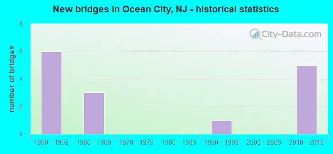
- New bridges - historical statistics
- 61950-1959
- 31960-1969
- 11990-1999
- 52010-2019


- Bridge Condition - Deck
- 44.4%Good
- 44.4%Satisfactory
- 11.1%Fair

- Bridge Condition - Superstructure
- 10.0%Very good
- 40.0%Good
- 40.0%Satisfactory
- 10.0%Fair

- Bridge Condition - Substructure
- 10.0%Very good
- 40.0%Good
- 40.0%Satisfactory
- 10.0%Fair
Find on map >> Show street view
Structure Number: 500004, Location: 0.6MI SW OF BAY AVE INTER (Lat: 39.254000, Lng: -74.630361), Route carried "on" structure: County highway 623, Year Built: 1962, Year Reconstructed: 2004, Status: Open, Structure Length: 49.62m (162.80ft), Average Daily Traffic: 19,000 (year 2020), Truck Traffic: 4%, Average Future Daily Traffic: 23,200 (year 2040), Design Load: HS 20, Features Intersected: SVC RDS,CROOK HORN THORO
Minimum Vertical Clearance: 30+ m (98+ ft), Kilometerpoint: 2.607, Lanes on structure: 2, Lanes under structure: 4, Base Highway Network: Yes, Owner: County Highway Agency, Approaching Roadway Width: 7.6m (24.9ft), Navigation Control: Yes ( Vertical Clearance: 10.7m (35.1ft), Horizontal Clearance: 24.4m (80.1ft)), Material/Design: Steel, Design/Construction: Girder and Floorbeam System, Number Of Spans In Main Unit: 1, Number Of Approach Spans: 30, Length of Maximum Span: 28.3m (92.8ft), Curb or Sidewalk Widths: Left: 0.8m (2.6ft), Right: 0.8m (2.6ft), Curb-To-Curb Width: 8.5m (27.9ft), Out-to-Out Width: 10.7m (35.1ft)
Condition: Deck: Good, Superstructure: Satisfactory, Substructure: Fair, Channel: Very good, Operating Rating: 32.7 metric tons, Method Used To Determine Operating Rating: Load Factor (LF), Inventory Rating: 20.0 metric tons, Method Used To Determine Inventory Rating: Load Factor (LF), Structural Evaluation: Somewhat better than minimum adequacy, Deck Geometry: Meets minimum limits, Underclear: Meets minimum limits, Waterway Adequacy: Equal to present desirable criteria, Approach Roadway Alignment: Better than present minimum criteria, Designated Inspection Frequency: Every 24 months, Critical Feature Inspection Frequency: Every 24 months, Underwater Inspection Frequency: Every 48 months, Inspection Date: June 2020, Critical Feature Inspection Date: June 2020, Underwater Inspection Date: August 2020, Deck Structure Type: Concrete Cast-file-Place, Wearing Surface/Protective System: Wearing Surface: Other
Find on map >> Show street view
Structure Number: 500016, Location: 5 miles North of CR 625 (Lat: 39.214950, Lng: -74.648461), Route carried "on" structure: County highway 619, Year Built: 1990, Status: Open, Structure Length: 26.91m (88.29ft), Average Daily Traffic: 880 (year 2020), Truck Traffic: 3%, Average Future Daily Traffic: 1,075 (year 2040), Design Load: HS 20+Mod, Features Intersected: MIDDLE THOROFARE
Minimum Vertical Clearance: 30+ m (98+ ft), Kilometerpoint: 26.715, Lanes on structure: 2, Owner: County Highway Agency, Approaching Roadway Width: 12.2m (40.0ft), Navigation Control: Yes ( Vertical Clearance: 4.6m (15.1ft), Horizontal Clearance: 22.9m (75.1ft)), Material/Design: Prestressed concrete continuous, Design/Construction: Stringer/Multi-beam, Number Of Spans In Main Unit: 11, Length of Maximum Span: 23.8m (78.1ft), Curb or Sidewalk Widths: Left: 3.0m (9.8ft), Right: 3.0m (9.8ft), Curb-To-Curb Width: 12.2m (40.0ft), Out-to-Out Width: 19.2m (63.0ft)
Condition: Deck: Good, Superstructure: Good, Substructure: Satisfactory, Channel: Very good, Inventory Rating: 55.3 metric tons, Method Used To Determine Inventory Rating: Load Factor (LF), Structural Evaluation: Equal to present minimum criteria, Deck Geometry: Equal to present desirable criteria, Waterway Adequacy: Superior to present desirable criteria, Approach Roadway Alignment: Equal to present desirable criteria, Designated Inspection Frequency: Every 24 months, Underwater Inspection Frequency: Every 48 months, Inspection Date: June 2020, Underwater Inspection Date: October 2018, Deck Structure Type: Concrete Cast-file-Place, Wearing Surface/Protective System: Wearing Surface: Monolithic Concrete, Deck Protection: Epoxy Coated Reinforcing
Find on map >> Show street view
Structure Number: 500032, Location: 05.MI NW OF ROOSEVELT BLV (Lat: 39.273461, Lng: -74.591639), Route carried "on" structure: City street , Year Built: 2018, Status: Open, Structure Length: 0.64m (2.10ft), Average Daily Traffic: 205 (year 2020), Truck Traffic: 1%, Average Future Daily Traffic: 245 (year 2040), Design Load: HL 93, Features Intersected: Venetian-Carnival Bayou, Facility Carried by Structure: West 17th Street
Minimum Vertical Clearance: 30.45m (99.90ft), Kilometerpoint: 0.000, Lanes on structure: 2, Owner: County Highway Agency, Approaching Roadway Width: 11.0m (36.1ft), Material/Design: Concrete, Design/Construction: Arch - Deck, Number Of Spans In Main Unit: 1, Length of Maximum Span: 6.1m (20.0ft), Curb or Sidewalk Widths: Left: 2.0m (6.6ft), Right: 2.0m (6.6ft), Curb-To-Curb Width: 11.0m (36.1ft), Out-to-Out Width: 15.5m (50.9ft)
Condition: Superstructure: Very good, Substructure: Very good, Channel: Very good, Operating Rating: 61.6 metric tons, Method Used To Determine Operating Rating: Load and Resistance Factor Rating (LRFR) rating reported by rating factor(RF) method using HL-93 loadings, Inventory Rating: 48.6 metric tons, Method Used To Determine Inventory Rating: Load and Resistance Factor Rating (LRFR) rating reported by rating factor(RF) method using HL-93 loadings, Structural Evaluation: Equal to present desirable criteria, Deck Geometry: Equal to present desirable criteria, Waterway Adequacy: Better than present minimum criteria, Approach Roadway Alignment: Better than present minimum criteria, Designated Inspection Frequency: Every 24 months, Inspection Date: June 2020
Find on map >> Show street view
Structure Number: 511155, Location: 2.2mi SE of RT9&52 JCT (Lat: 39.288331, Lng: -74.583169), Route carried "on" structure: ServiceState highway 52, Year Built: 2013, Status: Open, Structure Length: 12.22m (40.09ft), Average Daily Traffic: 541 (year 2021), Truck Traffic: 1%, Average Future Daily Traffic: 660 (year 2041), Design Load: HL 93, Features Intersected: Access Road
Minimum Vertical Clearance: 4.27m (14.01ft), Kilometerpoint: 0.805, Lanes on structure: 1, Lanes under structure: 1, Owner: State Highway Agency, Approaching Roadway Width: 15.2m (49.9ft), Skew: 9 degrees, Material/Design: Prestressed concrete continuous, Design/Construction: Tee Beam, Number Of Spans In Main Unit: 4, Length of Maximum Span: 32.6m (107.0ft), Curb or Sidewalk Widths: Left: 3.4m (11.2ft), Right: 2.0m (6.6ft), Curb-To-Curb Width: 15.2m (49.9ft), Out-to-Out Width: 21.3m (69.9ft)
Condition: Deck: Good, Superstructure: Good, Substructure: Good, Operating Rating: 96.9 metric tons, Method Used To Determine Operating Rating: Load and Resistance Factor Rating (LRFR) rating reported by rating factor(RF) method using HL-93 loadings, Inventory Rating: 96.9 metric tons, Method Used To Determine Inventory Rating: Load and Resistance Factor Rating (LRFR) rating reported by rating factor(RF) method using HL-93 loadings, Structural Evaluation: Better than present minimum criteria, Deck Geometry: Superior to present desirable criteria, Underclear: Meets minimum limits, Approach Roadway Alignment: Superior to present desirable criteria, Designated Inspection Frequency: Every 24 months, Inspection Date: June 2021, Deck Structure Type: Concrete Cast-file-Place, Wearing Surface/Protective System: Wearing Surface: Low Slump Concrete, Deck Protection: Epoxy Coated Reinforcing
Find on map >> Show street view
Structure Number: 511156, Location: 2.59 mi S of Rt US9 (Lat: 39.282311, Lng: -74.580889), Route carried "on" structure: State highway 52, Year Built: 2012, Status: Open, Structure Length: 167.85m (550.69ft), Average Daily Traffic: 22,968 (year 2020), Truck Traffic: 4%, Average Future Daily Traffic: 27,562 (year 2040), Design Load: HL 93, Features Intersected: Beach Thoro & Rainbow Ch
Minimum Vertical Clearance: 30.18m (99.02ft), Kilometerpoint: 0.241, Lanes on structure: 4, Base Highway Network: Yes, Owner: State Highway Agency, Approaching Roadway Width: 25.9m (85.0ft), Skew: 30 degrees, Navigation Control: Yes ( Vertical Clearance: 16.8m (55.1ft), Horizontal Clearance: 30.5m (100.1ft)), Material/Design: Prestressed concrete continuous, Design/Construction: Stringer/Multi-beam, Number Of Spans In Main Unit: 38, Length of Maximum Span: 49.1m (161.1ft), Curb or Sidewalk Widths: Left: 3.0m (9.8ft), Right: 0.0m, Curb-To-Curb Width: 25.8m (84.6ft), Out-to-Out Width: 27.5m (90.2ft)
Condition: Deck: Satisfactory, Superstructure: Good, Substructure: Good, Channel: Very good, Operating Rating: 70.3 metric tons, Method Used To Determine Operating Rating: Load and Resistance Factor Rating (LRFR) rating reported by rating factor(RF) method using HL-93 loadings, Inventory Rating: 38.9 metric tons, Method Used To Determine Inventory Rating: Load and Resistance Factor Rating (LRFR) rating reported by rating factor(RF) method using HL-93 loadings, Structural Evaluation: Better than present minimum criteria, Deck Geometry: Superior to present desirable criteria, Waterway Adequacy: Superior to present desirable criteria, Approach Roadway Alignment: Equal to present desirable criteria, Designated Inspection Frequency: Every 24 months, Underwater Inspection Frequency: Every 48 months, Inspection Date: May 2020, Underwater Inspection Date: May 2020, Deck Structure Type: Concrete Precast Panels, Wearing Surface/Protective System: Wearing Surface: Monolithic Concrete, Deck Protection: Epoxy Coated Reinforcing
Find on map >> Show street view
Structure Number: 511157, Location: 0.75 mi South Rt US9 (Lat: 39.300311, Lng: -74.591861), Route carried "on" structure: State highway 52, Year Built: 2012, Status: Open, Structure Length: 100.95m (331.20ft), Average Daily Traffic: 22,968 (year 2020), Truck Traffic: 4%, Average Future Daily Traffic: 27,562 (year 2040), Design Load: HL 93, Features Intersected: Ship Ch, Elbow Is. & Th.
Minimum Vertical Clearance: 30+ m (98+ ft), Kilometerpoint: 2.414, Lanes on structure: 4, Base Highway Network: Yes, Owner: State Highway Agency, Approaching Roadway Width: 22.6m (74.1ft), Skew: 30 degrees, Navigation Control: Yes ( Vertical Clearance: 16.8m (55.1ft), Horizontal Clearance: 30.5m (100.1ft)), Material/Design: Prestressed concrete continuous, Design/Construction: Stringer/Multi-beam, Number Of Spans In Main Unit: 22, Length of Maximum Span: 50.6m (166.0ft), Curb or Sidewalk Widths: Left: 3.0m (9.8ft), Right: 0.0m, Curb-To-Curb Width: 22.6m (74.1ft), Out-to-Out Width: 27.8m (91.2ft)
Condition: Deck: Good, Superstructure: Good, Substructure: Good, Channel: Very good, Operating Rating: 71.6 metric tons, Method Used To Determine Operating Rating: Load and Resistance Factor Rating (LRFR) rating reported by rating factor(RF) method using HL-93 loadings, Inventory Rating: 42.1 metric tons, Method Used To Determine Inventory Rating: Load and Resistance Factor Rating (LRFR) rating reported by rating factor(RF) method using HL-93 loadings, Structural Evaluation: Better than present minimum criteria, Deck Geometry: Superior to present desirable criteria, Waterway Adequacy: Superior to present desirable criteria, Approach Roadway Alignment: Superior to present desirable criteria, Designated Inspection Frequency: Every 24 months, Underwater Inspection Frequency: Every 48 months, Inspection Date: May 2020, Underwater Inspection Date: May 2020, Deck Structure Type: Concrete Precast Panels, Wearing Surface/Protective System: Wearing Surface: Monolithic Concrete, Deck Protection: Epoxy Coated Reinforcing
Find on map >> Show street view
Structure Number: 360231N, Location: 2.75 M NE OF RTS9&50 JCT (Lat: 39.235872, Lng: -74.666900), Route carried "on" structure: Other road GSP, Year Built: 1954, Status: Open, Structure Length: 3.41m (11.19ft), Average Daily Traffic: 14,110 (year 2021), Truck Traffic: 3%, Average Future Daily Traffic: 17,210 (year 2041), Design Load: HS 20, Features Intersected: PENN READING SEASHORE RR
Minimum Vertical Clearance: 30+ m (98+ ft), Kilometerpoint: 37.176, Lanes on structure: 2, Base Highway Network: Yes, Toll: On toll road, Owner: State Toll Authority, Approaching Roadway Width: 12.5m (41.0ft), Skew: 3 degrees, Material/Design: Steel continuous, Design/Construction: Stringer/Multi-beam, Number Of Spans In Main Unit: 3, Length of Maximum Span: 11.9m (39.0ft), Curb-To-Curb Width: 12.4m (40.7ft), Out-to-Out Width: 13.6m (44.6ft)
Condition: Deck: Fair, Superstructure: Satisfactory, Substructure: Satisfactory, Operating Rating: 37.9 metric tons, Method Used To Determine Operating Rating: Load and Resistance Factor Rating (LRFR) rating reported by rating factor(RF) method using HL-93 loadings, Inventory Rating: 29.2 metric tons, Method Used To Determine Inventory Rating: Load and Resistance Factor Rating (LRFR) rating reported by rating factor(RF) method using HL-93 loadings, Structural Evaluation: Equal to present minimum criteria, Deck Geometry: Better than present minimum criteria, Approach Roadway Alignment: Equal to present desirable criteria, Designated Inspection Frequency: Every 24 months, Inspection Date: May 2021, Deck Structure Type: Concrete Cast-file-Place, Wearing Surface/Protective System: Wearing Surface: Bituminous, Membrane: Preformed Fabric
Find on map >> Show street view
Structure Number: 360231S, Location: 2.75 M NE OF RTS9&50 JCT (Lat: 39.236139, Lng: -74.668356), Route carried "on" structure: Other road GSP, Year Built: 1954, Status: Open, Structure Length: 3.41m (11.19ft), Average Daily Traffic: 14,170 (year 2021), Truck Traffic: 3%, Average Future Daily Traffic: 17,290 (year 2041), Design Load: HS 20, Features Intersected: PENN READING SEASHORE RR
Minimum Vertical Clearance: 30+ m (98+ ft), Kilometerpoint: 37.176, Lanes on structure: 2, Base Highway Network: Yes, Toll: On toll road, Owner: State Toll Authority, Approaching Roadway Width: 12.5m (41.0ft), Skew: 3 degrees, Material/Design: Steel continuous, Design/Construction: Stringer/Multi-beam, Number Of Spans In Main Unit: 3, Length of Maximum Span: 11.9m (39.0ft), Curb-To-Curb Width: 12.4m (40.7ft), Out-to-Out Width: 13.6m (44.6ft)
Condition: Deck: Satisfactory, Superstructure: Satisfactory, Substructure: Good, Operating Rating: 37.9 metric tons, Method Used To Determine Operating Rating: Load and Resistance Factor Rating (LRFR) rating reported by rating factor(RF) method using HL-93 loadings, Inventory Rating: 29.2 metric tons, Method Used To Determine Inventory Rating: Load and Resistance Factor Rating (LRFR) rating reported by rating factor(RF) method using HL-93 loadings, Structural Evaluation: Equal to present minimum criteria, Deck Geometry: Better than present minimum criteria, Approach Roadway Alignment: Equal to present desirable criteria, Designated Inspection Frequency: Every 24 months, Inspection Date: May 2021, Deck Structure Type: Concrete Cast-file-Place, Wearing Surface/Protective System: Wearing Surface: Bituminous, Membrane: Preformed Fabric
Find on map >> Show street view
Structure Number: 360253N, Location: 2 MI S OF EGG HARBOR BR (Lat: 39.261903, Lng: -74.642697), Route carried "on" structure: Other road GSP, Year Built: 1954, Status: Open, Structure Length: 5.94m (19.49ft), Average Daily Traffic: 12,660 (year 2019), Truck Traffic: 3%, Average Future Daily Traffic: 15,450 (year 2039), Design Load: HS 20, Features Intersected: ROOSEVELT BLVD (CR 623)
Minimum Vertical Clearance: 30+ m (98+ ft), Kilometerpoint: 40.781, Lanes on structure: 2, Lanes under structure: 5, Base Highway Network: Yes, Toll: On toll road, Owner: State Toll Authority, Approaching Roadway Width: 12.5m (41.0ft), Skew: 1 degrees, Material/Design: Steel, Design/Construction: Stringer/Multi-beam, Number Of Spans In Main Unit: 3, Length of Maximum Span: 29.3m (96.1ft), Curb-To-Curb Width: 12.5m (41.0ft), Out-to-Out Width: 13.6m (44.6ft)
Condition: Deck: Satisfactory, Superstructure: Satisfactory, Substructure: Satisfactory, Operating Rating: 41.5 metric tons, Method Used To Determine Operating Rating: Load and Resistance Factor Rating (LRFR) rating reported by rating factor(RF) method using HL-93 loadings, Inventory Rating: 32.1 metric tons, Method Used To Determine Inventory Rating: Load and Resistance Factor Rating (LRFR) rating reported by rating factor(RF) method using HL-93 loadings, Structural Evaluation: Equal to present minimum criteria, Deck Geometry: Better than present minimum criteria, Underclear: Equal to present minimum criteria, Approach Roadway Alignment: Equal to present desirable criteria, Designated Inspection Frequency: Every 24 months, Inspection Date: May 2021, Deck Structure Type: Concrete Cast-file-Place, Wearing Surface/Protective System: Wearing Surface: Bituminous, Membrane: Preformed Fabric
Find on map >> Show street view
Structure Number: 360254S, Location: 2 MI S OF EGG HARBOR BR (Lat: 39.262250, Lng: -74.643192), Route carried "on" structure: Other road GSP, Year Built: 1954, Status: Open, Structure Length: 5.94m (19.49ft), Average Daily Traffic: 12,660 (year 2021), Truck Traffic: 3%, Average Future Daily Traffic: 15,450 (year 2041), Design Load: HS 20, Features Intersected: ROOSEVELT BLVD (CR 623)
Minimum Vertical Clearance: 30+ m (98+ ft), Kilometerpoint: 40.781, Lanes on structure: 2, Lanes under structure: 5, Base Highway Network: Yes, Toll: On toll road, Owner: State Toll Authority, Approaching Roadway Width: 12.5m (41.0ft), Skew: 1 degrees, Material/Design: Steel, Design/Construction: Stringer/Multi-beam, Number Of Spans In Main Unit: 3, Length of Maximum Span: 29.3m (96.1ft), Curb-To-Curb Width: 12.3m (40.4ft), Out-to-Out Width: 13.6m (44.6ft)
Condition: Deck: Satisfactory, Superstructure: Fair, Substructure: Satisfactory, Operating Rating: 36.0 metric tons, Method Used To Determine Operating Rating: Load and Resistance Factor Rating (LRFR) rating reported by rating factor(RF) method using HL-93 loadings, Inventory Rating: 27.9 metric tons, Method Used To Determine Inventory Rating: Load and Resistance Factor Rating (LRFR) rating reported by rating factor(RF) method using HL-93 loadings, Structural Evaluation: Somewhat better than minimum adequacy, Deck Geometry: Better than present minimum criteria, Underclear: Equal to present minimum criteria, Approach Roadway Alignment: Equal to present desirable criteria, Designated Inspection Frequency: Every 24 months, Inspection Date: May 2021, Deck Structure Type: Concrete Cast-file-Place, Wearing Surface/Protective System: Wearing Surface: Bituminous, Membrane: Preformed Fabric
Find on map >> Show street view
Structure Number: 500004, Location: 0.6MI SW OF BAY AVE INTER (Lat: 39.254000, Lng: -74.630361), Route carried "under" structure: ServiceOther road , Year Built: 1962, Structure Length: 0. m, Average Daily Traffic: 180 (year 2020), Truck Traffic: 3%, Features Intersected: SVC RDS,CROOK HORN THORO, Facility Carried by Structure: CR623(ROOSEVELT B)
Minimum Vertical Clearance: 4.47m (14.67ft), Kilometerpoint: 0.000, Lanes on structure: 2, Lanes under structure: 2, Material/Design: Steel, Design/Construction: Girder and Floorbeam System, Length of Maximum Span: 28.3m (92.8ft)
Find on map >> Show street view
Structure Number: 500004, Location: 0.6MI SW OF BAY AVE INTER (Lat: 39.254000, Lng: -74.630361), Route carried "under" structure: ServiceOther road , Year Built: 1962, Structure Length: 0. m, Average Daily Traffic: 180 (year 2020), Truck Traffic: 3%, Features Intersected: SVC RDS,CROOK HORN THORO, Facility Carried by Structure: CR623(ROOSEVELT B)
Minimum Vertical Clearance: 4.90m (16.08ft), Kilometerpoint: 0.000, Lanes on structure: 2, Lanes under structure: 2, Material/Design: Steel, Design/Construction: Girder and Floorbeam System, Length of Maximum Span: 28.3m (92.8ft)
Find on map >> Show street view
Structure Number: 511155, Location: 2.2mi SE of RT9&52 JCT (Lat: 39.288331, Lng: -74.583169), Route carried "under" structure: City street , Year Built: 2013, Structure Length: 0. m, Features Intersected: Access Road, Facility Carried by Structure: NJ 52 Ramp
Minimum Vertical Clearance: 4.27m (14.01ft), Kilometerpoint: 0.000, Lanes on structure: 1, Lanes under structure: 1, Material/Design: Prestressed concrete continuous, Design/Construction: Tee Beam, Length of Maximum Span: 32.6m (107.0ft)
Find on map >> Show street view
Structure Number: 360253N, Location: 2 MI S OF EGG HARBOR BR (Lat: 39.261903, Lng: -74.642697), Route carried "under" structure: County highway 623, Year Built: 1954, Structure Length: 0. m, Average Daily Traffic: 15,744 (year 2019), Truck Traffic: 4%, Features Intersected: ROOSEVELT BLVD (CR 623), Facility Carried by Structure: GSP NB
Minimum Vertical Clearance: 4.60m (15.09ft), Kilometerpoint: 0.531, Lanes on structure: 2, Lanes under structure: 5, Material/Design: Steel, Design/Construction: Stringer/Multi-beam, Length of Maximum Span: 29.3m (96.1ft)
Find on map >> Show street view
Structure Number: 360254S, Location: 2 MI S OF EGG HARBOR BR (Lat: 39.262250, Lng: -74.643192), Route carried "under" structure: County highway 623, Year Built: 1954, Structure Length: 0. m, Average Daily Traffic: 15,744 (year 2021), Truck Traffic: 4%, Features Intersected: ROOSEVELT BLVD (CR 623), Facility Carried by Structure: GSP SB
Minimum Vertical Clearance: 4.67m (15.32ft), Kilometerpoint: 0.451, Lanes on structure: 2, Lanes under structure: 5, Material/Design: Steel, Design/Construction: Stringer/Multi-beam, Length of Maximum Span: 29.3m (96.1ft)