Bridge Statistics for Odessa, Florida (FL)
Condition, Traffic, Stress, Structural Evaluation, Project Costs
- National Bridge Inventory (NBI) Statistics
- 12Number of bridges
- 328ft / 100mTotal length
- 353,500Total average daily traffic
- 29,030Total average daily truck traffic
- National Bridge Inventory (NBI) Registered Bridges for Odessa
- No street view available for this location
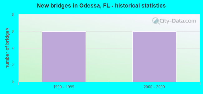
- New bridges - historical statistics
- 61990-1999
- 62000-2009
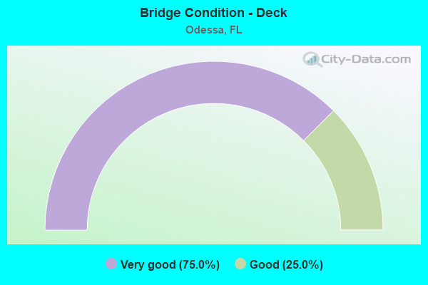
- Bridge Condition - Deck
- 75.0%Very good
- 25.0%Good
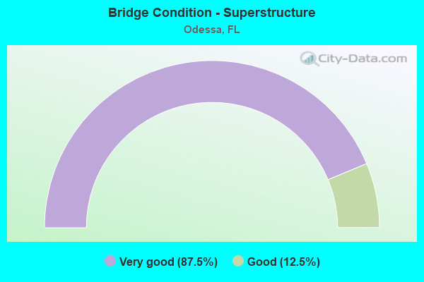
- Bridge Condition - Superstructure
- 87.5%Very good
- 12.5%Good
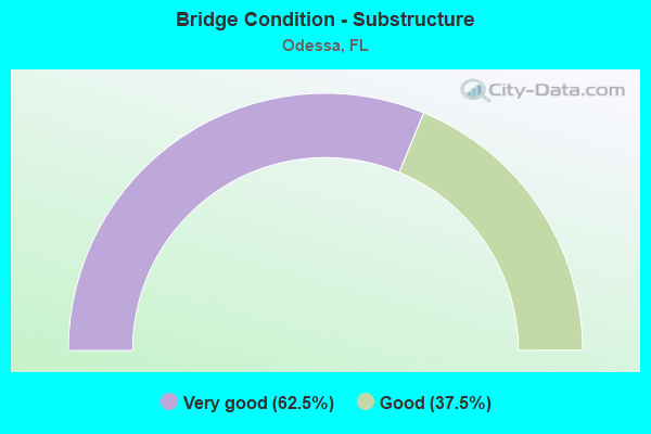
- Bridge Condition - Substructure
- 62.5%Very good
- 37.5%Good
Find on map >> Show street view
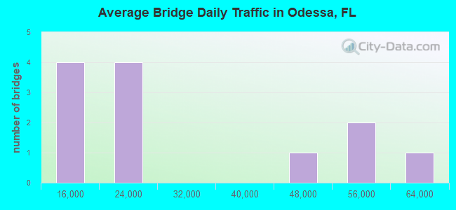
Structure Number: 14002, Location: 0.6 MI W OF SR-589 (Lat: 28.185681, Lng: -82.553483), Route carried "on" structure: State highway 54, Year Built: 2004, Status: Open, Structure Length: 1.12m (3.67ft), Average Daily Traffic: 56,000 (year 2021), Truck Traffic: 6%, Average Future Daily Traffic: 97,160 (year 2041), Design Load: HS 20+Mod, Features Intersected: ANCLOTE RIVER BRANCH
Minimum Vertical Clearance: 30+ m (98+ ft), Kilometerpoint: 4.144, Lanes on structure: 8, Base Highway Network: Yes, Owner: State Highway Agency, Approaching Roadway Width: 31.1m (102.0ft), Skew: 20 degrees, Material/Design: Concrete, Design/Construction: Culvert, Number Of Spans In Main Unit: 3, Length of Maximum Span: 3.9m (12.8ft)
Condition: Channel: Good, Culverts: Good, Operating Rating: 55.2 metric tons, Method Used To Determine Operating Rating: Load Factor (LF), Inventory Rating: 33.0 metric tons, Method Used To Determine Inventory Rating: Load Factor (LF), Structural Evaluation: Better than present minimum criteria, Waterway Adequacy: Equal to present desirable criteria, Approach Roadway Alignment: Equal to present desirable criteria, Designated Inspection Frequency: Every 24 months, Underwater Inspection Frequency: Every 24 months, Inspection Date: Febuary 2021, Underwater Inspection Date: Febuary 2021
Find on map >> Show street view
Structure Number: 140069, Location: 0.8MI SOUTH OF SR 54 (Lat: 28.178742, Lng: -82.537494), Route carried "on" structure: State highway 589, Year Built: 1999, Status: Open, Structure Length: 10.24m (33.60ft), Average Daily Traffic: 22,150 (year 2020), Truck Traffic: 10%, Average Future Daily Traffic: 38,430 (year 2042), Design Load: HS 20+Mod, Features Intersected: S BRANCH ANCLOTE RIVER
Minimum Vertical Clearance: 30+ m (98+ ft), Kilometerpoint: 0.649, Lanes on structure: 2, Base Highway Network: Yes, Toll: On toll road, Owner: State Toll Authority, Approaching Roadway Width: 12.1m (39.7ft), Skew: 3 degrees, Material/Design: Prestressed concrete, Design/Construction: Stringer/Multi-beam, Number Of Spans In Main Unit: 7, Length of Maximum Span: 14.6m (47.9ft), Curb-To-Curb Width: 12.1m (39.7ft), Out-to-Out Width: 12.8m (42.0ft)
Condition: Deck: Very good, Superstructure: Very good, Substructure: Good, Channel: Good, Operating Rating: 44.0 metric tons, Method Used To Determine Operating Rating: Load Factor (LF), Inventory Rating: 29.9 metric tons, Method Used To Determine Inventory Rating: Load Factor (LF), Structural Evaluation: Better than present minimum criteria, Deck Geometry: Equal to present minimum criteria, Waterway Adequacy: Superior to present desirable criteria, Approach Roadway Alignment: Equal to present desirable criteria, Designated Inspection Frequency: Every 24 months, Inspection Date: July 2020, Deck Structure Type: Concrete Cast-file-Place
Find on map >> Show street view
Structure Number: 14007, Location: 0.8MI SOUTH OF SR 54 (Lat: 28.178742, Lng: -82.537781), Route carried "on" structure: State highway 589, Year Built: 1999, Status: Open, Structure Length: 10.24m (33.60ft), Average Daily Traffic: 22,150 (year 2020), Truck Traffic: 10%, Average Future Daily Traffic: 38,430 (year 2042), Design Load: HS 20+Mod, Features Intersected: S BRANCH ANCLOTE RIVER
Minimum Vertical Clearance: 30+ m (98+ ft), Kilometerpoint: 0.657, Lanes on structure: 2, Base Highway Network: Yes, Toll: On toll road, Owner: State Toll Authority, Approaching Roadway Width: 12.1m (39.7ft), Skew: 3 degrees, Material/Design: Prestressed concrete, Design/Construction: Stringer/Multi-beam, Number Of Spans In Main Unit: 7, Length of Maximum Span: 14.6m (47.9ft), Curb or Sidewalk Widths: Left: 3.5m (11.5ft), Right: 0.0m, Curb-To-Curb Width: 12.1m (39.7ft), Out-to-Out Width: 16.8m (55.1ft)
Condition: Deck: Very good, Superstructure: Very good, Substructure: Very good, Channel: Good, Operating Rating: 38.7 metric tons, Method Used To Determine Operating Rating: Load and Resistance Factor (LRFR), Inventory Rating: 29.9 metric tons, Method Used To Determine Inventory Rating: Load and Resistance Factor (LRFR), Structural Evaluation: Better than present minimum criteria, Deck Geometry: Equal to present minimum criteria, Waterway Adequacy: Superior to present desirable criteria, Approach Roadway Alignment: Equal to present desirable criteria, Designated Inspection Frequency: Every 24 months, Inspection Date: July 2020, Deck Structure Type: Concrete Cast-file-Place
Find on map >> Show street view
Structure Number: 140071, Location: 0.3MI SOUTH OF SR 54 (Lat: 28.185506, Lng: -82.540917), Route carried "on" structure: State highway 589, Year Built: 2000, Status: Open, Structure Length: 1.29m (4.23ft), Average Daily Traffic: 44,300 (year 2020), Truck Traffic: 10%, Average Future Daily Traffic: 76,860 (year 2042), Design Load: HS 20+Mod, Features Intersected: DRAINAGE DITCH
Minimum Vertical Clearance: 30+ m (98+ ft), Kilometerpoint: 1.526, Lanes on structure: 6, Base Highway Network: Yes, Toll: On toll road, Owner: State Toll Authority, Approaching Roadway Width: 36.6m (120.1ft), Skew: 10 degrees, Material/Design: Concrete, Design/Construction: Culvert, Number Of Spans In Main Unit: 4, Length of Maximum Span: 2.8m (9.2ft)
Condition: Channel: Good, Culverts: Good, Operating Rating: 77.9 metric tons, Method Used To Determine Operating Rating: Load Factor (LF), Inventory Rating: 46.8 metric tons, Method Used To Determine Inventory Rating: Load Factor (LF), Structural Evaluation: Better than present minimum criteria, Waterway Adequacy: Superior to present desirable criteria, Approach Roadway Alignment: Equal to present desirable criteria, Designated Inspection Frequency: Every 24 months, Inspection Date: July 2020
Find on map >> Show street view
Structure Number: 140072, Location: 2.45MI NOF LUTZ LAKE FERN (Lat: 28.189611, Lng: -82.543906), Route carried "on" structure: State highway 589, Year Built: 1999, Status: Open, Structure Length: 5.72m (18.77ft), Average Daily Traffic: 22,150 (year 2020), Truck Traffic: 10%, Average Future Daily Traffic: 38,430 (year 2042), Design Load: HS 20+Mod, Features Intersected: SR 54
Minimum Vertical Clearance: 30+ m (98+ ft), Kilometerpoint: 2.041, Lanes on structure: 2, Lanes under structure: 10, Base Highway Network: Yes, Toll: On toll road, Owner: State Toll Authority, Approaching Roadway Width: 12.0m (39.4ft), Material/Design: Prestressed concrete, Design/Construction: Stringer/Multi-beam, Number Of Spans In Main Unit: 2, Length of Maximum Span: 28.6m (93.8ft), Curb-To-Curb Width: 12.1m (39.7ft), Out-to-Out Width: 12.8m (42.0ft)
Condition: Deck: Very good, Superstructure: Good, Substructure: Very good, Operating Rating: 38.2 metric tons, Method Used To Determine Operating Rating: Load and Resistance Factor (LRFR), Inventory Rating: 32.7 metric tons, Method Used To Determine Inventory Rating: Load and Resistance Factor (LRFR), Structural Evaluation: Better than present minimum criteria, Deck Geometry: Equal to present minimum criteria, Underclear: Better than present minimum criteria, Approach Roadway Alignment: Equal to present desirable criteria, Designated Inspection Frequency: Every 24 months, Inspection Date: July 2020, Deck Structure Type: Concrete Cast-file-Place
Find on map >> Show street view
Structure Number: 140073, Location: 2.45MI NOF LUTZ LAKE FERN (Lat: 28.189489, Lng: -82.544158), Route carried "on" structure: State highway 589, Year Built: 1999, Status: Open, Structure Length: 5.72m (18.77ft), Average Daily Traffic: 22,150 (year 2020), Truck Traffic: 10%, Average Future Daily Traffic: 38,430 (year 2042), Design Load: HS 20+Mod, Features Intersected: SR 54
Minimum Vertical Clearance: 30+ m (98+ ft), Kilometerpoint: 2.044, Lanes on structure: 2, Lanes under structure: 10, Base Highway Network: Yes, Toll: On toll road, Owner: State Toll Authority, Approaching Roadway Width: 11.9m (39.0ft), Material/Design: Prestressed concrete, Design/Construction: Stringer/Multi-beam, Number Of Spans In Main Unit: 2, Length of Maximum Span: 28.6m (93.8ft), Curb-To-Curb Width: 12.1m (39.7ft), Out-to-Out Width: 12.8m (42.0ft)
Condition: Deck: Very good, Superstructure: Very good, Substructure: Very good, Operating Rating: 38.2 metric tons, Method Used To Determine Operating Rating: Load and Resistance Factor (LRFR), Inventory Rating: 32.7 metric tons, Method Used To Determine Inventory Rating: Load and Resistance Factor (LRFR), Structural Evaluation: Equal to present desirable criteria, Deck Geometry: Equal to present minimum criteria, Underclear: Better than present minimum criteria, Approach Roadway Alignment: Equal to present desirable criteria, Designated Inspection Frequency: Every 24 months, Inspection Date: July 2020, Deck Structure Type: Concrete Cast-file-Place
Find on map >> Show street view
Structure Number: 140074, Location: 1.7MI NORTH OF SR 54 (Lat: 28.214381, Lng: -82.548656), Route carried "on" structure: State highway 589, Year Built: 2000, Status: Open, Structure Length: 7.32m (24.02ft), Average Daily Traffic: 15,650 (year 2020), Truck Traffic: 10%, Average Future Daily Traffic: 27,153 (year 2042), Design Load: HS 20+Mod, Features Intersected: SANDY BRANCH RIVER
Minimum Vertical Clearance: 30+ m (98+ ft), Kilometerpoint: 4.839, Lanes on structure: 2, Base Highway Network: Yes, Toll: On toll road, Owner: State Toll Authority, Approaching Roadway Width: 12.1m (39.7ft), Material/Design: Prestressed concrete, Design/Construction: Stringer/Multi-beam, Number Of Spans In Main Unit: 4, Length of Maximum Span: 18.3m (60.0ft), Curb-To-Curb Width: 12.1m (39.7ft), Out-to-Out Width: 12.8m (42.0ft)
Condition: Deck: Good, Superstructure: Very good, Substructure: Very good, Channel: Good, Operating Rating: 59.0 metric tons, Method Used To Determine Operating Rating: Load Factor (LF), Inventory Rating: 36.3 metric tons, Method Used To Determine Inventory Rating: Load Factor (LF), Structural Evaluation: Equal to present desirable criteria, Deck Geometry: Better than present minimum criteria, Waterway Adequacy: Superior to present desirable criteria, Approach Roadway Alignment: Equal to present desirable criteria, Designated Inspection Frequency: Every 24 months, Inspection Date: July 2020, Deck Structure Type: Concrete Cast-file-Place
Find on map >> Show street view
Structure Number: 140075, Location: 1.7MI NORTH OF SR 54 (Lat: 28.214356, Lng: -82.548939), Route carried "on" structure: State highway 589, Year Built: 2000, Status: Open, Structure Length: 7.32m (24.02ft), Average Daily Traffic: 15,650 (year 2020), Truck Traffic: 10%, Average Future Daily Traffic: 27,153 (year 2042), Design Load: HS 20+Mod, Features Intersected: SANDY BRANCH RIVER
Minimum Vertical Clearance: 30+ m (98+ ft), Kilometerpoint: 4.839, Lanes on structure: 2, Base Highway Network: Yes, Toll: On toll road, Owner: State Toll Authority, Approaching Roadway Width: 12.1m (39.7ft), Material/Design: Prestressed concrete, Design/Construction: Stringer/Multi-beam, Number Of Spans In Main Unit: 4, Length of Maximum Span: 18.3m (60.0ft), Curb or Sidewalk Widths: Left: 3.6m (11.8ft), Right: 0.0m, Curb-To-Curb Width: 12.1m (39.7ft), Out-to-Out Width: 16.8m (55.1ft)
Condition: Deck: Good, Superstructure: Very good, Substructure: Good, Channel: Good, Operating Rating: 51.7 metric tons, Method Used To Determine Operating Rating: Load Factor (LF), Inventory Rating: 32.7 metric tons, Method Used To Determine Inventory Rating: Load Factor (LF), Structural Evaluation: Better than present minimum criteria, Deck Geometry: Better than present minimum criteria, Waterway Adequacy: Superior to present desirable criteria, Approach Roadway Alignment: Equal to present desirable criteria, Designated Inspection Frequency: Every 24 months, Inspection Date: July 2020, Deck Structure Type: Concrete Cast-file-Place
Find on map >> Show street view
Structure Number: 140076, Location: 3.2MI NORTH OF SR 54 (Lat: 28.237672, Lng: -82.550342), Route carried "on" structure: State highway 589, Year Built: 2000, Status: Open, Structure Length: 25.76m (84.51ft), Average Daily Traffic: 15,650 (year 2020), Truck Traffic: 10%, Average Future Daily Traffic: 27,153 (year 2042), Design Load: HS 20+Mod, Features Intersected: ANCLOTE RIVER
Minimum Vertical Clearance: 30+ m (98+ ft), Kilometerpoint: 7.331, Lanes on structure: 2, Base Highway Network: Yes, Toll: On toll road, Owner: State Toll Authority, Approaching Roadway Width: 11.2m (36.7ft), Material/Design: Prestressed concrete, Design/Construction: Stringer/Multi-beam, Number Of Spans In Main Unit: 13, Length of Maximum Span: 19.8m (65.0ft), Curb-To-Curb Width: 12.1m (39.7ft), Out-to-Out Width: 12.8m (42.0ft)
Condition: Deck: Very good, Superstructure: Very good, Substructure: Good, Channel: Good, Operating Rating: 63.5 metric tons, Method Used To Determine Operating Rating: Load Factor (LF), Inventory Rating: 39.0 metric tons, Method Used To Determine Inventory Rating: Load Factor (LF), Structural Evaluation: Better than present minimum criteria, Deck Geometry: Better than present minimum criteria, Waterway Adequacy: Superior to present desirable criteria, Approach Roadway Alignment: Equal to present desirable criteria, Designated Inspection Frequency: Every 24 months, Inspection Date: July 2020, Deck Structure Type: Concrete Cast-file-Place
Find on map >> Show street view
Structure Number: 140077, Location: 3.2MI NORTH OF SR 54 (Lat: 28.237672, Lng: -82.550633), Route carried "on" structure: State highway 589, Year Built: 2000, Status: Open, Structure Length: 25.76m (84.51ft), Average Daily Traffic: 15,650 (year 2020), Truck Traffic: 10%, Average Future Daily Traffic: 27,153 (year 2042), Design Load: HS 20+Mod, Features Intersected: ANCLOTE RIVER
Minimum Vertical Clearance: 30+ m (98+ ft), Kilometerpoint: 7.331, Lanes on structure: 2, Base Highway Network: Yes, Toll: On toll road, Owner: State Toll Authority, Approaching Roadway Width: 11.2m (36.7ft), Material/Design: Prestressed concrete, Design/Construction: Stringer/Multi-beam, Number Of Spans In Main Unit: 13, Length of Maximum Span: 19.8m (65.0ft), Curb or Sidewalk Widths: Left: 3.5m (11.5ft), Right: 0.0m, Curb-To-Curb Width: 12.1m (39.7ft), Out-to-Out Width: 16.8m (55.1ft)
Condition: Deck: Very good, Superstructure: Very good, Substructure: Very good, Channel: Good, Operating Rating: 59.9 metric tons, Method Used To Determine Operating Rating: Load Factor (LF), Inventory Rating: 37.2 metric tons, Method Used To Determine Inventory Rating: Load Factor (LF), Structural Evaluation: Equal to present desirable criteria, Deck Geometry: Better than present minimum criteria, Waterway Adequacy: Superior to present desirable criteria, Approach Roadway Alignment: Equal to present desirable criteria, Designated Inspection Frequency: Every 24 months, Inspection Date: July 2020, Deck Structure Type: Concrete Cast-file-Place
Find on map >> Show street view
Structure Number: 140072, Location: 2.45MI NOF LUTZ LAKE FERN (Lat: 28.189611, Lng: -82.543906), Route carried "under" structure: State highway 54, Year Built: 1999, Structure Length: 0. m, Average Daily Traffic: 51,000 (year 2020), Truck Traffic: 6%, Features Intersected: SR 54, Facility Carried by Structure: SR 589 NB SCP 18.7
Minimum Vertical Clearance: 5.12m (16.80ft), Kilometerpoint: 5.166, Lanes on structure: 2, Lanes under structure: 10, Material/Design: Prestressed concrete, Design/Construction: Stringer/Multi-beam, Length of Maximum Span: 28.6m (93.8ft)
Find on map >> Show street view
Structure Number: 140073, Location: 2.45MI NOF LUTZ LAKE FERN (Lat: 28.189489, Lng: -82.544158), Route carried "under" structure: State highway 54, Year Built: 1999, Structure Length: 0. m, Average Daily Traffic: 51,000 (year 2020), Truck Traffic: 6%, Features Intersected: SR 54, Facility Carried by Structure: SR 589 SB SCP 18.7
Minimum Vertical Clearance: 5.61m (18.41ft), Kilometerpoint: 5.166, Lanes on structure: 2, Lanes under structure: 10, Material/Design: Prestressed concrete, Design/Construction: Stringer/Multi-beam, Length of Maximum Span: 28.6m (93.8ft)