Bridge Statistics for Orange Cove, California (CA)
Condition, Traffic, Stress, Structural Evaluation, Project Costs
- National Bridge Inventory (NBI) Statistics
- 21Number of bridges
- 187ft / 56.5mTotal length
- 33,235Total average daily traffic
- 1,676Total average daily truck traffic
- 68,415Total future (year 2037) average daily traffic
- National Bridge Inventory (NBI) Registered Bridges for Orange Cove
- No street view available for this location
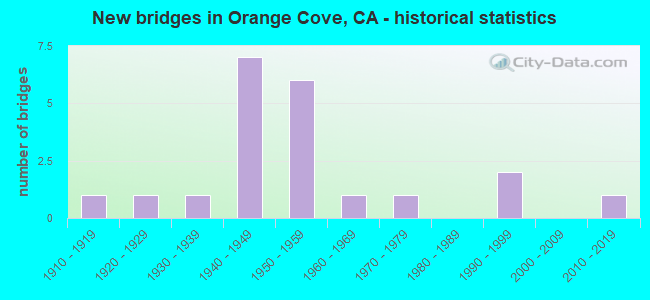
- New bridges - historical statistics
- 11910-1919
- 11920-1929
- 11930-1939
- 71940-1949
- 61950-1959
- 11960-1969
- 11970-1979
- 21990-1999
- 12010-2019

- Reconstructed bridges - Historical Statistics
- 11930-1939
- 11940-1949
- 11950-1959
- 11960-1969


- Bridge Condition - Deck
- 68.4%Good
- 31.6%Fair

- Bridge Condition - Superstructure
- 78.9%Good
- 21.1%Fair

- Bridge Condition - Substructure
- 15.8%Good
- 84.2%Fair

- Bridge Condition - Channel
- 4.8%Excellent
- 23.8%Very good
- 33.3%Good
- 33.3%Satisfactory
- 4.8%Serious
Find on map >> Show street view
Structure Number: 42C0173, Location: 0.4 MI E OF DOUGLAS AVE (Lat: 36.603775, Lng: -120.489589), Route carried "on" structure: County highway , Year Built: 1966, Status: Open, Structure Length: 7.35m (24.11ft), Average Daily Traffic: 900 (year 2017), Truck Traffic: 5%, Average Future Daily Traffic: 920 (year 2037), Design Load: HS 20, Features Intersected: San Luis Canal, Facility Carried by Structure: W Manning Ave
Minimum Vertical Clearance: 30+ m (98+ ft), Kilometerpoint: 189.009, Lanes on structure: 2, Owner: Bureau of Reclamation, Maintenance Responsibility: State Agenciy, Approaching Roadway Width: 9.1m (29.9ft), Skew: 2 degrees, Material/Design: Prestressed concrete, Design/Construction: Stringer/Multi-beam, Number Of Spans In Main Unit: 3, Length of Maximum Span: 23.5m (77.1ft), Curb or Sidewalk Widths: Left: 0.6m (2.0ft), Right: 0.6m (2.0ft), Curb-To-Curb Width: 8.5m (27.9ft), Out-to-Out Width: 9.8m (32.2ft)
Condition: Deck: Good, Superstructure: Good, Substructure: Good, Channel: Excellent, Operating Rating: 99.0 metric tons, Method Used To Determine Operating Rating: Load Factor (LF), Inventory Rating: 32.4 metric tons, Method Used To Determine Inventory Rating: Load Factor (LF), Structural Evaluation: Better than present minimum criteria, Deck Geometry: Somewhat better than minimum adequacy, Waterway Adequacy: Superior to present desirable criteria, Approach Roadway Alignment: Equal to present desirable criteria, Designated Inspection Frequency: Every 48 months, Underwater Inspection Frequency: Every 60 months, Inspection Date: October 2018, Underwater Inspection Date: May 2018, Deck Structure Type: Concrete Cast-file-Place
Find on map >> Show street view
Structure Number: 42C009, Location: 0.2 MI N OF DINUBA AVE (Lat: 36.592672, Lng: -119.640625), Route carried "on" structure: County highway , Year Built: 1912, Year Reconstructed: 1941, Status: Open, Structure Length: 1.31m (4.30ft), Average Daily Traffic: 4,000 (year 2011), Truck Traffic: 10%, Average Future Daily Traffic: 13,348 (year 2042), Features Intersected: FOWLER SWITCH CANAL, Facility Carried by Structure: S GOLDEN STATE BL
Minimum Vertical Clearance: 30+ m (98+ ft), Kilometerpoint: 0.000, Lanes on structure: 4, Owner: County Highway Agency, Approaching Roadway Width: 10.4m (34.1ft), Skew: 20 degrees, Material/Design: Concrete continuous, Design/Construction: Tee Beam, Number Of Spans In Main Unit: 2, Length of Maximum Span: 6.4m (21.0ft), Curb or Sidewalk Widths: Left: 0.3m (1.0ft), Right: 0.3m (1.0ft), Curb-To-Curb Width: 22.0m (72.2ft), Out-to-Out Width: 32.4m (106.3ft)
Condition: Deck: Good, Superstructure: Fair, Substructure: Fair, Channel: Good, Operating Rating: 28.2 metric tons, Method Used To Determine Operating Rating: Field evaluation and documented engineering judgment, Inventory Rating: 16.8 metric tons, Method Used To Determine Inventory Rating: Field evaluation and documented engineering judgment, Structural Evaluation: Meets minimum limits, Deck Geometry: Superior to present desirable criteria, Waterway Adequacy: Equal to present desirable criteria, Approach Roadway Alignment: Equal to present desirable criteria, Designated Inspection Frequency: Every 24 months, Inspection Date: January 2022, Deck Structure Type: Concrete Cast-file-Place, Wearing Surface/Protective System: Wearing Surface: Bituminous
Find on map >> Show street view
Structure Number: 42C0091, Location: WEST OF HILLS VALLEY RD (Lat: 36.624433, Lng: -119.305783), Route carried "on" structure: City street , Year Built: 1948, Status: Open, Structure Length: 1.86m (6.10ft), Average Daily Traffic: 6,000 (year 2010), Truck Traffic: 2%, Average Future Daily Traffic: 10,000 (year 2040), Features Intersected: FRIANT-KERN CANAL, Facility Carried by Structure: PARK BLVD
Minimum Vertical Clearance: 30+ m (98+ ft), Kilometerpoint: 0.000, Lanes on structure: 2, Owner: City or Municipal Highway Agency, Approaching Roadway Width: 6.7m (22.0ft), Skew: 30 degrees, Material/Design: Concrete continuous, Design/Construction: Culvert, Number Of Spans In Main Unit: 5, Length of Maximum Span: 3.7m (12.1ft)
Condition: Channel: Very good, Culverts: Satisfactory, Operating Rating: 54.1 metric tons, Method Used To Determine Operating Rating: Field evaluation and documented engineering judgment, Inventory Rating: 32.4 metric tons, Method Used To Determine Inventory Rating: Field evaluation and documented engineering judgment, Structural Evaluation: Equal to present minimum criteria, Waterway Adequacy: Superior to present desirable criteria, Approach Roadway Alignment: Equal to present desirable criteria, Length Of Structure Improvement: 1.86m (6.10ft), Designated Inspection Frequency: Every 48 months, Underwater Inspection Frequency: Every 72 months, Inspection Date: December 2020, Underwater Inspection Date: December 2020
Find on map >> Show street view
Structure Number: 42C0176, Location: 0.2 MI E OF HILL AVE (Lat: 36.603050, Lng: -119.335444), Route carried "on" structure: County highway , Year Built: 1951, Status: Open, Structure Length: 1.58m (5.18ft), Average Daily Traffic: 3,600 (year 2012), Truck Traffic: 5%, Average Future Daily Traffic: 10,758 (year 2040), Features Intersected: ALTA EAST BRANCH CANAL, Facility Carried by Structure: E MANNING AVE
Minimum Vertical Clearance: 30+ m (98+ ft), Kilometerpoint: 0.000, Lanes on structure: 2, Owner: County Highway Agency, Approaching Roadway Width: 6.7m (22.0ft), Skew: 2 degrees, Material/Design: Concrete continuous, Design/Construction: Slab, Number Of Spans In Main Unit: 3, Length of Maximum Span: 6.1m (20.0ft), Curb or Sidewalk Widths: Left: 0.2m (0.7ft), Right: 0.2m (0.7ft), Curb-To-Curb Width: 8.5m (27.9ft), Out-to-Out Width: 9.4m (30.8ft)
Condition: Deck: Good, Superstructure: Good, Substructure: Fair, Channel: Good, Operating Rating: 49.6 metric tons, Method Used To Determine Operating Rating: Load Factor (LF), Inventory Rating: 29.8 metric tons, Method Used To Determine Inventory Rating: Load Factor (LF), Structural Evaluation: Somewhat better than minimum adequacy, Deck Geometry: Meets minimum limits, Waterway Adequacy: Better than present minimum criteria, Approach Roadway Alignment: Equal to present desirable criteria, Designated Inspection Frequency: Every 24 months, Inspection Date: December 2020, Deck Structure Type: Concrete Cast-file-Place, Wearing Surface/Protective System: Wearing Surface: Bituminous
Find on map >> Show street view
Structure Number: 42C0177, Location: 0.2 MI SOUTH OF PARK BLVD (Lat: 36.621086, Lng: -119.304853), Route carried "on" structure: City street , Year Built: 1947, Status: Open, Structure Length: 5.58m (18.31ft), Average Daily Traffic: 5,835 (year 2012), Truck Traffic: 5%, Average Future Daily Traffic: 9,225 (year 2040), Design Load: H 15, Features Intersected: FRIANT-KERN CANAL, Facility Carried by Structure: S HILLS VALLEY RD
Minimum Vertical Clearance: 30+ m (98+ ft), Kilometerpoint: 0.000, Lanes on structure: 2, Owner: City or Municipal Highway Agency, Approaching Roadway Width: 7.3m (24.0ft), Skew: 4 degrees, Material/Design: Concrete continuous, Design/Construction: Tee Beam, Number Of Spans In Main Unit: 4, Length of Maximum Span: 14.4m (47.2ft), Curb or Sidewalk Widths: Left: 0.3m (1.0ft), Right: 0.3m (1.0ft), Curb-To-Curb Width: 9.1m (29.9ft), Out-to-Out Width: 9.8m (32.2ft)
Condition: Deck: Good, Superstructure: Good, Substructure: Fair, Channel: Very good, Operating Rating: 18.1 metric tons, Method Used To Determine Operating Rating: Load and Resistance Factor Rating (LRFR) rating reported by rating factor(RF) method using HL-93 loadings, Inventory Rating: 13.6 metric tons, Method Used To Determine Inventory Rating: Load and Resistance Factor Rating (LRFR) rating reported by rating factor(RF) method using HL-93 loadings, Structural Evaluation: High priority of corrective action, Deck Geometry: High priority of corrective action, Waterway Adequacy: Superior to present desirable criteria, Approach Roadway Alignment: Equal to present desirable criteria, Designated Inspection Frequency: Every 24 months, Inspection Date: December 2020, Deck Structure Type: Concrete Cast-file-Place, Wearing Surface/Protective System: Wearing Surface: Bituminous
Find on map >> Show street view
Structure Number: 42C028, Location: 1.03 MI W OF RUSSELL AVE (Lat: 36.890633, Lng: -120.673381), Route carried "on" structure: County highway , Year Built: 1950, Year Reconstructed: 1968, Status: Open, Structure Length: 3.38m (11.09ft), Average Daily Traffic: 600 (year 2011), Truck Traffic: 8%, Average Future Daily Traffic: 2,398 (year 2040), Design Load: H 15, Features Intersected: DELTA-MENDOTA CANAL, Facility Carried by Structure: W ALTHEA AVE
Minimum Vertical Clearance: 30+ m (98+ ft), Kilometerpoint: 0.000, Lanes on structure: 2, Owner: County Highway Agency, Approaching Roadway Width: 7.0m (23.0ft), Skew: 1 degrees, Material/Design: Concrete, Design/Construction: Tee Beam, Number Of Spans In Main Unit: 3, Length of Maximum Span: 11.0m (36.1ft), Curb or Sidewalk Widths: Left: 0.4m (1.3ft), Right: 0.4m (1.3ft), Curb-To-Curb Width: 8.5m (27.9ft), Out-to-Out Width: 9.8m (32.2ft)
Condition: Deck: Good, Superstructure: Good, Substructure: Fair, Channel: Very good, Operating Rating: 52.8 metric tons, Method Used To Determine Operating Rating: Load Factor (LF), Inventory Rating: 31.8 metric tons, Method Used To Determine Inventory Rating: Load Factor (LF), Structural Evaluation: Somewhat better than minimum adequacy, Deck Geometry: Somewhat better than minimum adequacy, Waterway Adequacy: Better than present minimum criteria, Approach Roadway Alignment: Equal to present desirable criteria, Designated Inspection Frequency: Every 24 months, Underwater Inspection Frequency: Every 72 months, Inspection Date: December 2021, Underwater Inspection Date: December 2020, Deck Structure Type: Concrete Cast-file-Place, Wearing Surface/Protective System: Wearing Surface: Bituminous
Find on map >> Show street view
Structure Number: 42C0288, Location: 0.1 MI WEST OF SR 63 (Lat: 36.631661, Lng: -119.306131), Route carried "on" structure: City street , Year Built: 1955, Status: Open, Structure Length: 3.66m (12.01ft), Average Daily Traffic: 1,050 (year 2012), Truck Traffic: 5%, Average Future Daily Traffic: 1,550 (year 2040), Design Load: H 15, Features Intersected: FRIANT-KERN CANAL, Facility Carried by Structure: E ADAMS AVE
Minimum Vertical Clearance: 30+ m (98+ ft), Kilometerpoint: 0.000, Lanes on structure: 2, Owner: City or Municipal Highway Agency, Approaching Roadway Width: 4.9m (16.1ft), Material/Design: Concrete continuous, Design/Construction: Tee Beam, Number Of Spans In Main Unit: 3, Length of Maximum Span: 12.8m (42.0ft), Curb or Sidewalk Widths: Left: 0.3m (1.0ft), Right: 0.3m (1.0ft), Curb-To-Curb Width: 7.3m (24.0ft), Out-to-Out Width: 8.7m (28.5ft)
Condition: Deck: Fair, Superstructure: Good, Substructure: Fair, Channel: Very good, Operating Rating: 40.2 metric tons, Method Used To Determine Operating Rating: Load Factor (LF), Inventory Rating: 24.3 metric tons, Method Used To Determine Inventory Rating: Load Factor (LF), Structural Evaluation: Somewhat better than minimum adequacy, Deck Geometry: Meets minimum limits, Waterway Adequacy: Superior to present desirable criteria, Approach Roadway Alignment: Equal to present desirable criteria, Designated Inspection Frequency: Every 24 months, Inspection Date: December 2020, Deck Structure Type: Concrete Cast-file-Place
Find on map >> Show street view
Structure Number: 42C0406, Location: 1.4 MI S OF MANNING AVE (Lat: 36.583736, Lng: -119.331847), Route carried "on" structure: County highway , Year Built: 1975, Status: Open, Structure Length: 1.92m (6.30ft), Average Daily Traffic: 625 (year 2010), Truck Traffic: 10%, Average Future Daily Traffic: 850 (year 2040), Design Load: HS 20+Mod, Features Intersected: ALTA EAST BRANCH CANAL, Facility Carried by Structure: MONSON AVE
Minimum Vertical Clearance: 30+ m (98+ ft), Kilometerpoint: 0.000, Lanes on structure: 2, Owner: County Highway Agency, Approaching Roadway Width: 4.9m (16.1ft), Skew: 3 degrees, Material/Design: Concrete continuous, Design/Construction: Slab, Number Of Spans In Main Unit: 3, Length of Maximum Span: 6.1m (20.0ft), Curb-To-Curb Width: 8.5m (27.9ft), Out-to-Out Width: 8.7m (28.5ft)
Condition: Deck: Fair, Superstructure: Fair, Substructure: Fair, Channel: Good, Operating Rating: 54.1 metric tons, Method Used To Determine Operating Rating: Field evaluation and documented engineering judgment, Inventory Rating: 32.4 metric tons, Method Used To Determine Inventory Rating: Field evaluation and documented engineering judgment, Structural Evaluation: Somewhat better than minimum adequacy, Deck Geometry: Somewhat better than minimum adequacy, Waterway Adequacy: Better than present minimum criteria, Approach Roadway Alignment: Equal to present desirable criteria, Designated Inspection Frequency: Every 24 months, Inspection Date: December 2020, Deck Structure Type: Concrete Cast-file-Place
Find on map >> Show street view
Structure Number: 42C0407, Location: 0.7 MI N OF MANNING AVE (Lat: 36.612836, Lng: -119.340525), Route carried "on" structure: County highway , Year Built: 1940, Year Reconstructed: 1950, Status: Open, Structure Length: 3.87m (12.70ft), Average Daily Traffic: 2,900 (year 2012), Truck Traffic: 5%, Average Future Daily Traffic: 6,856 (year 2040), Features Intersected: ALTA EAST BRANCH CANAL, Facility Carried by Structure: S HILL AVE
Minimum Vertical Clearance: 30+ m (98+ ft), Kilometerpoint: 0.000, Lanes on structure: 2, Owner: County Highway Agency, Approaching Roadway Width: 7.6m (24.9ft), Skew: 5 degrees, Material/Design: Concrete continuous, Design/Construction: Slab, Number Of Spans In Main Unit: 6, Length of Maximum Span: 6.4m (21.0ft), Curb or Sidewalk Widths: Left: 0.2m (0.7ft), Right: 0.2m (0.7ft), Curb-To-Curb Width: 8.2m (26.9ft), Out-to-Out Width: 9.0m (29.5ft)
Condition: Deck: Good, Superstructure: Good, Substructure: Fair, Channel: Satisfactory, Operating Rating: 28.2 metric tons, Method Used To Determine Operating Rating: Field evaluation and documented engineering judgment, Inventory Rating: 16.8 metric tons, Method Used To Determine Inventory Rating: Field evaluation and documented engineering judgment, Structural Evaluation: Meets minimum limits, Deck Geometry: High priority of corrective action, Waterway Adequacy: Better than present minimum criteria, Approach Roadway Alignment: Equal to present desirable criteria, Designated Inspection Frequency: Every 24 months, Inspection Date: December 2020, Deck Structure Type: Concrete Cast-file-Place, Wearing Surface/Protective System: Wearing Surface: Bituminous
Find on map >> Show street view
Structure Number: 42C0409, Location: 0.5 MI WEST OF HILL AVE (Lat: 36.625061, Lng: -119.348961), Route carried "on" structure: County highway , Year Built: 1950, Status: Open, Structure Length: 2.01m (6.59ft), Average Daily Traffic: 200 (year 2010), Truck Traffic: 5%, Average Future Daily Traffic: 408 (year 2040), Features Intersected: ALTA EAST BRANCH CANAL, Facility Carried by Structure: E SUMNER AVE
Minimum Vertical Clearance: 30+ m (98+ ft), Kilometerpoint: 0.000, Lanes on structure: 2, Owner: County Highway Agency, Approaching Roadway Width: 4.6m (15.1ft), Skew: 1 degrees, Material/Design: Concrete continuous, Design/Construction: Slab, Number Of Spans In Main Unit: 3, Length of Maximum Span: 7.6m (24.9ft), Curb or Sidewalk Widths: Left: 0.2m (0.7ft), Right: 0.2m (0.7ft), Curb-To-Curb Width: 6.5m (21.3ft), Out-to-Out Width: 7.3m (24.0ft)
Condition: Deck: Fair, Superstructure: Fair, Substructure: Fair, Channel: Satisfactory, Operating Rating: 35.6 metric tons, Method Used To Determine Operating Rating: Load Factor (LF), Inventory Rating: 21.4 metric tons, Method Used To Determine Inventory Rating: Load Factor (LF), Structural Evaluation: Somewhat better than minimum adequacy, Deck Geometry: Meets minimum limits, Waterway Adequacy: Better than present minimum criteria, Approach Roadway Alignment: Equal to present desirable criteria, Designated Inspection Frequency: Every 24 months, Inspection Date: December 2020, Deck Structure Type: Concrete Cast-file-Place
Find on map >> Show street view
Structure Number: 42C041, Location: 1.15 MI E OF CRAWFORD AVE (Lat: 36.632447, Lng: -119.355444), Route carried "on" structure: County highway , Year Built: 1950, Status: Open, Structure Length: 1.86m (6.10ft), Average Daily Traffic: 2,500 (year 2007), Truck Traffic: 5%, Average Future Daily Traffic: 5,063 (year 2040), Features Intersected: ALTA EAST BRANCH CANAL, Facility Carried by Structure: E ADAMS AVE
Minimum Vertical Clearance: 30+ m (98+ ft), Kilometerpoint: 0.000, Lanes on structure: 2, Owner: County Highway Agency, Approaching Roadway Width: 7.0m (23.0ft), Material/Design: Concrete continuous, Design/Construction: Slab, Number Of Spans In Main Unit: 3, Length of Maximum Span: 6.7m (22.0ft), Curb or Sidewalk Widths: Left: 0.2m (0.7ft), Right: 0.2m (0.7ft), Curb-To-Curb Width: 8.5m (27.9ft), Out-to-Out Width: 9.4m (30.8ft)
Condition: Deck: Good, Superstructure: Good, Substructure: Fair, Channel: Satisfactory, Operating Rating: 40.5 metric tons, Method Used To Determine Operating Rating: Field evaluation and documented engineering judgment, Inventory Rating: 24.3 metric tons, Method Used To Determine Inventory Rating: Field evaluation and documented engineering judgment, Structural Evaluation: Somewhat better than minimum adequacy, Deck Geometry: Meets minimum limits, Waterway Adequacy: Better than present minimum criteria, Approach Roadway Alignment: Equal to present desirable criteria, Designated Inspection Frequency: Every 24 months, Inspection Date: December 2020, Deck Structure Type: Concrete Cast-file-Place, Wearing Surface/Protective System: Wearing Surface: Bituminous
Find on map >> Show street view
Structure Number: 42C0411, Location: 0.4 MI E OF CRAWFORD AVE (Lat: 36.654372, Lng: -119.368933), Route carried "on" structure: County highway , Year Built: 1940, Status: Open, Structure Length: 1.71m (5.61ft), Average Daily Traffic: 350 (year 2010), Truck Traffic: 10%, Average Future Daily Traffic: 428 (year 2040), Features Intersected: ALTA EAST BRANCH CANAL, Facility Carried by Structure: E JEFFERSON AVE
Minimum Vertical Clearance: 30+ m (98+ ft), Kilometerpoint: 0.000, Lanes on structure: 2, Owner: County Highway Agency, Approaching Roadway Width: 5.5m (18.0ft), Skew: 1 degrees, Material/Design: Concrete continuous, Design/Construction: Slab, Number Of Spans In Main Unit: 3, Length of Maximum Span: 5.8m (19.0ft), Curb or Sidewalk Widths: Left: 0.2m (0.7ft), Right: 0.2m (0.7ft), Curb-To-Curb Width: 8.5m (27.9ft), Out-to-Out Width: 9.4m (30.8ft)
Condition: Deck: Good, Superstructure: Good, Substructure: Fair, Channel: Good, Operating Rating: 38.9 metric tons, Method Used To Determine Operating Rating: Load Factor (LF), Inventory Rating: 23.3 metric tons, Method Used To Determine Inventory Rating: Load Factor (LF), Structural Evaluation: Somewhat better than minimum adequacy, Deck Geometry: Equal to present minimum criteria, Waterway Adequacy: Better than present minimum criteria, Approach Roadway Alignment: Equal to present desirable criteria, Designated Inspection Frequency: Every 24 months, Inspection Date: November 2020, Deck Structure Type: Concrete Cast-file-Place, Wearing Surface/Protective System: Wearing Surface: Bituminous
Find on map >> Show street view
Structure Number: 42C0424, Location: 0.2 MI E OF CRAWFORD AVE (Lat: 36.618142, Lng: -119.373136), Route carried "on" structure: County highway , Year Built: 1925, Year Reconstructed: 1945, Status: Open, Structure Length: 0.73m (2.40ft), Average Daily Traffic: 1,300 (year 2010), Truck Traffic: 5%, Average Future Daily Traffic: 1,505 (year 2040), Features Intersected: CALIFORNIA VINYARD DITCH, Facility Carried by Structure: E SOUTH AVE
Minimum Vertical Clearance: 30+ m (98+ ft), Kilometerpoint: 0.000, Lanes on structure: 2, Owner: County Highway Agency, Approaching Roadway Width: 6.7m (22.0ft), Skew: 3 degrees, Material/Design: Concrete continuous, Design/Construction: Slab, Number Of Spans In Main Unit: 2, Length of Maximum Span: 3.5m (11.5ft), Curb or Sidewalk Widths: Left: 0.1m (0.3ft), Right: 0.1m (0.3ft), Curb-To-Curb Width: 7.5m (24.6ft), Out-to-Out Width: 7.9m (25.9ft)
Condition: Deck: Good, Superstructure: Good, Substructure: Fair, Channel: Good, Operating Rating: 56.7 metric tons, Method Used To Determine Operating Rating: Load Factor (LF), Inventory Rating: 34.0 metric tons, Method Used To Determine Inventory Rating: Load Factor (LF), Structural Evaluation: Somewhat better than minimum adequacy, Deck Geometry: Meets minimum limits, Waterway Adequacy: Better than present minimum criteria, Approach Roadway Alignment: Equal to present minimum criteria, Designated Inspection Frequency: Every 24 months, Inspection Date: November 2020, Deck Structure Type: Concrete Cast-file-Place, Wearing Surface/Protective System: Wearing Surface: Bituminous
Find on map >> Show street view
Structure Number: 42C0503, Location: 0.15 MI W OF S HILL AVE (Lat: 36.617669, Lng: -119.343203), Route carried "on" structure: County highway , Year Built: 1991, Status: Open, Structure Length: 2.01m (6.59ft), Average Daily Traffic: 1,700 (year 2011), Truck Traffic: 1%, Average Future Daily Traffic: 2,330 (year 2040), Features Intersected: ALTA EAST BRANCH CANAL, Facility Carried by Structure: E SOUTH AVE
Minimum Vertical Clearance: 30+ m (98+ ft), Kilometerpoint: 0.000, Lanes on structure: 2, Owner: County Highway Agency, Approaching Roadway Width: 8.5m (27.9ft), Skew: 3 degrees, Material/Design: Concrete continuous, Design/Construction: Slab, Number Of Spans In Main Unit: 3, Length of Maximum Span: 6.7m (22.0ft), Curb-To-Curb Width: 8.5m (27.9ft), Out-to-Out Width: 9.6m (31.5ft)
Condition: Deck: Good, Superstructure: Good, Substructure: Fair, Channel: Good, Operating Rating: 54.1 metric tons, Method Used To Determine Operating Rating: Field evaluation and documented engineering judgment, Inventory Rating: 32.4 metric tons, Method Used To Determine Inventory Rating: Field evaluation and documented engineering judgment, Structural Evaluation: Somewhat better than minimum adequacy, Deck Geometry: Somewhat better than minimum adequacy, Waterway Adequacy: Equal to present desirable criteria, Approach Roadway Alignment: Equal to present desirable criteria, Designated Inspection Frequency: Every 24 months, Inspection Date: December 2020, Deck Structure Type: Concrete Cast-file-Place
Find on map >> Show street view
Structure Number: 42C0563, Location: 0.9 MI N/O MANNING AVE (Lat: 36.616436, Lng: -119.376556), Route carried "on" structure: County highway , Year Built: 1937, Status: Open, Structure Length: 0.64m (2.10ft), Average Daily Traffic: 1,000 (year 2009), Truck Traffic: 5%, Average Future Daily Traffic: 1,715 (year 2040), Features Intersected: CALIFORNIA VINYARD DITCH, Facility Carried by Structure: S CRAWFORD AVE
Minimum Vertical Clearance: 30+ m (98+ ft), Kilometerpoint: 0.000, Lanes on structure: 2, Owner: County Highway Agency, Approaching Roadway Width: 7.0m (23.0ft), Skew: 2 degrees, Material/Design: Concrete continuous, Design/Construction: Slab, Number Of Spans In Main Unit: 2, Length of Maximum Span: 2.7m (8.9ft), Curb or Sidewalk Widths: Left: 0.1m (0.3ft), Right: 0.1m (0.3ft), Curb-To-Curb Width: 6.9m (22.6ft), Out-to-Out Width: 7.3m (24.0ft)
Condition: Deck: Good, Superstructure: Good, Substructure: Fair, Channel: Satisfactory, Operating Rating: 28.5 metric tons, Method Used To Determine Operating Rating: Load Factor (LF), Inventory Rating: 17.2 metric tons, Method Used To Determine Inventory Rating: Load Factor (LF), Structural Evaluation: Meets minimum limits, Deck Geometry: Meets minimum limits, Waterway Adequacy: Better than present minimum criteria, Approach Roadway Alignment: Equal to present desirable criteria, Designated Inspection Frequency: Every 24 months, Inspection Date: November 2020, Deck Structure Type: Concrete Cast-file-Place, Wearing Surface/Protective System: Wearing Surface: Bituminous
Find on map >> Show street view
Structure Number: 46C019, Location: 0.19 MI S OF A456 (Lat: 36.614108, Lng: -119.269225), Route carried "on" structure: County highway , Year Built: 1950, Status: Open, Structure Length: 2.10m (6.89ft), Average Daily Traffic: 125 (year 1978), Truck Traffic: 5%, Average Future Daily Traffic: 160 (year 2041), Features Intersected: SAND CREEK, Facility Carried by Structure: ROAD 136
Minimum Vertical Clearance: 30+ m (98+ ft), Kilometerpoint: 0.000, Lanes on structure: 2, Owner: County Highway Agency, Approaching Roadway Width: 7.9m (25.9ft), Material/Design: Concrete continuous, Design/Construction: Slab, Number Of Spans In Main Unit: 4, Length of Maximum Span: 5.8m (19.0ft), Curb or Sidewalk Widths: Left: 0.3m (1.0ft), Right: 0.3m (1.0ft), Curb-To-Curb Width: 7.9m (25.9ft), Out-to-Out Width: 8.5m (27.9ft)
Condition: Deck: Good, Superstructure: Good, Substructure: Fair, Channel: Satisfactory, Operating Rating: 51.2 metric tons, Method Used To Determine Operating Rating: Load Factor (LF), Inventory Rating: 30.8 metric tons, Method Used To Determine Inventory Rating: Load Factor (LF), Structural Evaluation: Somewhat better than minimum adequacy, Deck Geometry: Somewhat better than minimum adequacy, Waterway Adequacy: Better than present minimum criteria, Approach Roadway Alignment: Equal to present desirable criteria, Designated Inspection Frequency: Every 24 months, Inspection Date: December 2021, Deck Structure Type: Concrete Cast-file-Place
Find on map >> Show street view
Structure Number: 46C0222, Location: 0.1 MI WEST OF ROAD 124 (Lat: 36.602547, Lng: -119.297247), Route carried "on" structure: County highway , Year Built: 1947, Status: Open, Structure Length: 4.57m (14.99ft), Average Daily Traffic: 100 (year 1978), Truck Traffic: 5%, Average Future Daily Traffic: 160 (year 2041), Design Load: H 15, Features Intersected: FRIANT-KERN CANAL, Facility Carried by Structure: AVE 448 (MANNING)
Minimum Vertical Clearance: 30+ m (98+ ft), Kilometerpoint: 0.000, Lanes on structure: 2, Owner: County Highway Agency, Approaching Roadway Width: 7.3m (24.0ft), Skew: 3 degrees, Material/Design: Concrete continuous, Design/Construction: Tee Beam, Number Of Spans In Main Unit: 4, Length of Maximum Span: 11.9m (39.0ft), Curb or Sidewalk Widths: Left: 0.4m (1.3ft), Right: 0.4m (1.3ft), Curb-To-Curb Width: 7.3m (24.0ft), Out-to-Out Width: 8.0m (26.2ft)
Condition: Deck: Fair, Superstructure: Good, Substructure: Fair, Channel: Satisfactory, Operating Rating: 21.4 metric tons, Method Used To Determine Operating Rating: Load and Resistance Factor Rating (LRFR) rating reported by rating factor(RF) method using HL-93 loadings, Inventory Rating: 16.5 metric tons, Method Used To Determine Inventory Rating: Load and Resistance Factor Rating (LRFR) rating reported by rating factor(RF) method using HL-93 loadings, Structural Evaluation: Somewhat better than minimum adequacy, Deck Geometry: Equal to present minimum criteria, Waterway Adequacy: Superior to present desirable criteria, Approach Roadway Alignment: Equal to present desirable criteria, Designated Inspection Frequency: Every 24 months, Inspection Date: December 2021, Deck Structure Type: Concrete Cast-file-Place
Find on map >> Show street view
Structure Number: 46C0223, Location: 0.2 MI WEST OF RD 124 (Lat: 36.609803, Lng: -119.298114), Route carried "on" structure: County highway , Year Built: 1949, Status: Open, Structure Length: 3.66m (12.01ft), Average Daily Traffic: 100 (year 1978), Truck Traffic: 5%, Average Future Daily Traffic: 160 (year 2041), Design Load: H 15, Features Intersected: FRIANT-KERN CANAL, Facility Carried by Structure: AVE 452
Minimum Vertical Clearance: 30+ m (98+ ft), Kilometerpoint: 0.000, Lanes on structure: 2, Owner: County Highway Agency, Approaching Roadway Width: 7.3m (24.0ft), Material/Design: Concrete continuous, Design/Construction: Tee Beam, Number Of Spans In Main Unit: 3, Length of Maximum Span: 12.8m (42.0ft), Curb or Sidewalk Widths: Left: 0.4m (1.3ft), Right: 0.4m (1.3ft), Curb-To-Curb Width: 7.3m (24.0ft), Out-to-Out Width: 8.0m (26.2ft)
Condition: Deck: Fair, Superstructure: Good, Substructure: Fair, Channel: Satisfactory, Operating Rating: 20.7 metric tons, Method Used To Determine Operating Rating: Load and Resistance Factor Rating (LRFR) rating reported by rating factor(RF) method using HL-93 loadings, Inventory Rating: 15.9 metric tons, Method Used To Determine Inventory Rating: Load and Resistance Factor Rating (LRFR) rating reported by rating factor(RF) method using HL-93 loadings, Structural Evaluation: Meets minimum limits, Deck Geometry: Equal to present minimum criteria, Waterway Adequacy: Superior to present desirable criteria, Approach Roadway Alignment: Equal to present desirable criteria, Designated Inspection Frequency: Every 24 months, Inspection Date: December 2021, Deck Structure Type: Concrete Cast-file-Place
Find on map >> Show street view
Structure Number: 46C0441, Location: 025. MI E OF RD 136 (Lat: 36.616942, Lng: -119.264267), Route carried "on" structure: County highway , Year Built: 1999, Status: Open, Structure Length: 2.82m (9.25ft), Average Daily Traffic: 100 (year 1998), Truck Traffic: 5%, Average Future Daily Traffic: 160 (year 2041), Design Load: HS 20+Mod, Features Intersected: SAND CREEK, Facility Carried by Structure: AVE 456
Minimum Vertical Clearance: 30+ m (98+ ft), Kilometerpoint: 0.000, Lanes on structure: 2, Owner: County Highway Agency, Approaching Roadway Width: 8.6m (28.2ft), Skew: 1 degrees, Material/Design: Concrete continuous, Design/Construction: Slab, Number Of Spans In Main Unit: 3, Length of Maximum Span: 9.1m (29.9ft), Curb-To-Curb Width: 8.6m (28.2ft), Out-to-Out Width: 9.6m (31.5ft)
Condition: Deck: Fair, Superstructure: Fair, Substructure: Good, Channel: Serious, Operating Rating: 32.1 metric tons, Method Used To Determine Operating Rating: Load and Resistance Factor Rating (LRFR) rating reported by rating factor(RF) method using HL-93 loadings, Inventory Rating: 22.0 metric tons, Method Used To Determine Inventory Rating: Load and Resistance Factor Rating (LRFR) rating reported by rating factor(RF) method using HL-93 loadings, Structural Evaluation: Somewhat better than minimum adequacy, Deck Geometry: Better than present minimum criteria, Waterway Adequacy: Equal to present desirable criteria, Approach Roadway Alignment: Equal to present desirable criteria, Designated Inspection Frequency: Every 24 months, Inspection Date: December 2021, Deck Structure Type: Concrete Cast-file-Place
Find on map >> Show street view
Structure Number: 46C0464, Location: 0.25 MI E OF SR 63 (Lat: 36.603625, Lng: -119.282264), Route carried "on" structure: County highway , Year Built: 2018, Status: Open, Structure Length: 2.13m (6.99ft), Average Daily Traffic: 200 (year 1978), Truck Traffic: 5%, Average Future Daily Traffic: 321 (year 2041), Design Load: HL 93, Features Intersected: SAND CREEK, Facility Carried by Structure: ROLLER DR
Minimum Vertical Clearance: 30+ m (98+ ft), Kilometerpoint: 0.000, Lanes on structure: 2, Owner: County Highway Agency, Approaching Roadway Width: 9.7m (31.8ft), Material/Design: Prestressed concrete continuous, Design/Construction: Slab, Number Of Spans In Main Unit: 1, Length of Maximum Span: 19.2m (63.0ft), Curb-To-Curb Width: 9.7m (31.8ft), Out-to-Out Width: 10.7m (35.1ft)
Condition: Deck: Good, Superstructure: Good, Substructure: Good, Channel: Good, Operating Rating: 42.1 metric tons, Method Used To Determine Operating Rating: Field evaluation and documented engineering judgment, Inventory Rating: 32.4 metric tons, Method Used To Determine Inventory Rating: Field evaluation and documented engineering judgment, Structural Evaluation: Better than present minimum criteria, Deck Geometry: Equal to present minimum criteria, Waterway Adequacy: Equal to present desirable criteria, Approach Roadway Alignment: Equal to present desirable criteria, Designated Inspection Frequency: Every 48 months, Inspection Date: December 2021, Deck Structure Type: Concrete Cast-file-Place
Find on map >> Show street view
Structure Number: FKC MP43.92, Location: SE Orange Cove (Lat: 36.617181, Lng: -119.303900), Route carried "on" structure: City street , Year Built: 1948, Status: Open, Structure Length: 1.80m (5.91ft), Average Daily Traffic: 50 (year 2020), Average Future Daily Traffic: 100 (year 2040), Design Load: Railroad, Features Intersected: Friant-Kern Canal, Facility Carried by Structure: Ave. 456
Minimum Vertical Clearance: 30+ m (98+ ft), Kilometerpoint: 70.667, Lanes on structure: 2, Owner: Bureau of Reclamation, Maintenance Responsibility: Local Agency, Approaching Roadway Width: 7.3m (24.0ft), Material/Design: Concrete continuous, Design/Construction: Culvert, Number Of Spans In Main Unit: 5, Length of Maximum Span: 3.4m (11.2ft)
Condition: Channel: Very good, Culverts: Satisfactory, Waterway Adequacy: Superior to present desirable criteria, Approach Roadway Alignment: Equal to present minimum criteria, Designated Inspection Frequency: Every 48 months, Underwater Inspection Frequency: Every 60 months, Inspection Date: January 2021