Bridge Statistics for Palm City, Florida (FL)
Condition, Traffic, Stress, Structural Evaluation, Project Costs
- National Bridge Inventory (NBI) Statistics
- 38Number of bridges
- 1,473ft / 449mTotal length
- $2,632,000Total costs
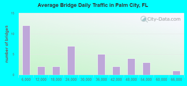
- 843,888Total average daily traffic
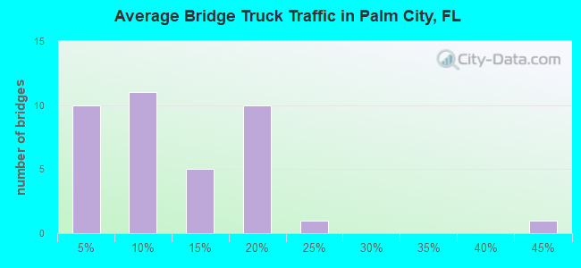
- 110,442Total average daily truck traffic
- National Bridge Inventory (NBI) Registered Bridges for Palm City
- No street view available for this location
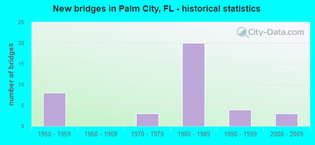
- New bridges - historical statistics
- 81950-1959
- 31970-1979
- 201980-1989
- 41990-1999
- 32000-2009
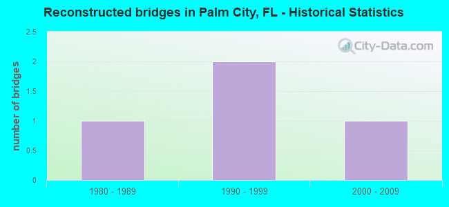
- Reconstructed bridges - Historical Statistics
- 11980-1989
- 21990-1999
- 12000-2009
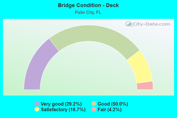
- Bridge Condition - Deck
- 29.2%Very good
- 50.0%Good
- 16.7%Satisfactory
- 4.2%Fair
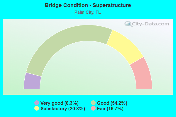
- Bridge Condition - Superstructure
- 8.3%Very good
- 54.2%Good
- 20.8%Satisfactory
- 16.7%Fair
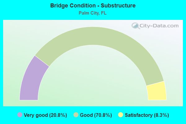
- Bridge Condition - Substructure
- 20.8%Very good
- 70.8%Good
- 8.3%Satisfactory
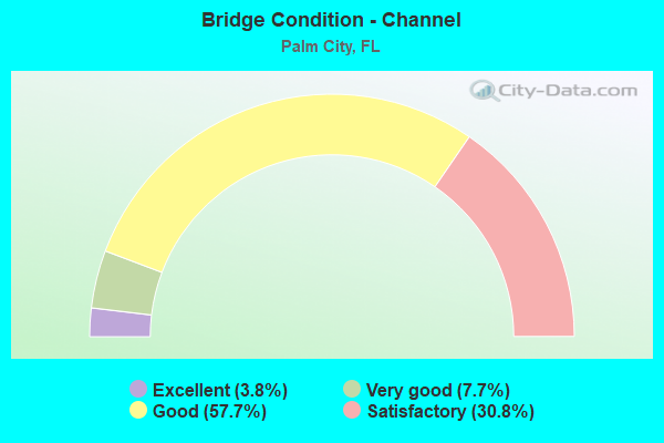
- Bridge Condition - Channel
- 3.8%Excellent
- 7.7%Very good
- 57.7%Good
- 30.8%Satisfactory
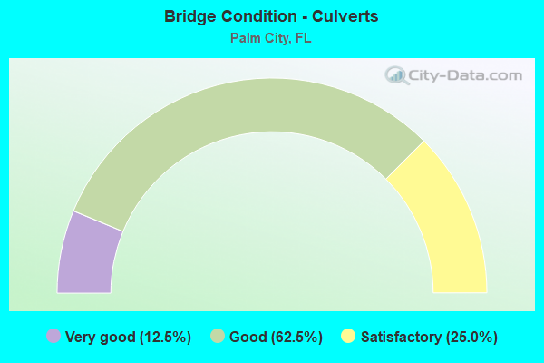
- Bridge Condition - Culverts
- 12.5%Very good
- 62.5%Good
- 25.0%Satisfactory
Find on map >> Show street view
Structure Number: 890038, Location: SR-714 East of Fla. Tpke. (Lat: 27.174139, Lng: -80.260833), Route carried "on" structure: State highway 714, Year Built: 1970, Status: Open, Structure Length: 56.30m (184.71ft), Average Daily Traffic: 19,000 (year 2020), Truck Traffic: 5%, Average Future Daily Traffic: 32,965 (year 2042), Design Load: HS 20, Features Intersected: S Fork St. Lucie River, Facility Carried by Structure: EB Martin Downs Bl
Minimum Vertical Clearance: 30+ m (98+ ft), Kilometerpoint: 22.886, Lanes on structure: 2, Base Highway Network: Yes, Owner: State Highway Agency, Approaching Roadway Width: 11.2m (36.7ft), Navigation Control: Yes ( Vertical Clearance: 16.8m (55.1ft), Horizontal Clearance: 27.4m (89.9ft)), Material/Design: Prestressed concrete, Design/Construction: Stringer/Multi-beam, Number Of Spans In Main Unit: 24, Length of Maximum Span: 34.4m (112.9ft), Curb-To-Curb Width: 12.2m (40.0ft), Out-to-Out Width: 12.9m (42.3ft)
Condition: Deck: Satisfactory, Superstructure: Satisfactory, Substructure: Good, Channel: Good, Operating Rating: 52.6 metric tons, Method Used To Determine Operating Rating: Load Factor (LF), Inventory Rating: 45.4 metric tons, Method Used To Determine Inventory Rating: Load Factor (LF), Structural Evaluation: Equal to present minimum criteria, Deck Geometry: Better than present minimum criteria, Waterway Adequacy: Superior to present desirable criteria, Approach Roadway Alignment: Better than present minimum criteria, Designated Inspection Frequency: Every 24 months, Underwater Inspection Frequency: Every 20 months, Inspection Date: July 2020, Underwater Inspection Date: November 2020, Deck Structure Type: Concrete Cast-file-Place
Find on map >> Show street view
Structure Number: 890066, Location: 3.7MI S/O STUART INT. (Lat: 27.117672, Lng: -80.274944), Route carried "on" structure: State highway 91, Year Built: 1957, Year Reconstructed: 2004, Status: Open, Structure Length: 83.82m (275.00ft), Average Daily Traffic: 21,150 (year 2021), Truck Traffic: 19%, Average Future Daily Traffic: 36,695 (year 2042), Design Load: HS 20+Mod, Features Intersected: ST LUCIE CANAL
Minimum Vertical Clearance: 30+ m (98+ ft), Kilometerpoint: 20.752, Lanes on structure: 2, Base Highway Network: Yes, Toll: On toll road, Owner: State Toll Authority, Approaching Roadway Width: 19.0m (62.3ft), Skew: 2 degrees, Navigation Control: Yes ( Vertical Clearance: 16.7m (54.8ft), Horizontal Clearance: 2.7m (8.9ft)), Material/Design: Steel, Design/Construction: Stringer/Multi-beam, Number Of Spans In Main Unit: 1, Number Of Approach Spans: 31, Length of Maximum Span: 43.3m (142.1ft), Curb-To-Curb Width: 18.3m (60.0ft), Out-to-Out Width: 19.2m (63.0ft)
Condition: Deck: Good, Superstructure: Good, Substructure: Satisfactory, Channel: Good, Operating Rating: 66.0 metric tons, Method Used To Determine Operating Rating: Load Factor (LF), Inventory Rating: 39.6 metric tons, Method Used To Determine Inventory Rating: Load Factor (LF), Structural Evaluation: Equal to present minimum criteria, Deck Geometry: Superior to present desirable criteria, Waterway Adequacy: Superior to present desirable criteria, Approach Roadway Alignment: Better than present minimum criteria, Length Of Structure Improvement: 83.79m (274.90ft), Designated Inspection Frequency: Every 24 months, Underwater Inspection Frequency: Every 24 months, Inspection Date: November 2021, Underwater Inspection Date: November 2021, Bridge Improvement Cost: $2,492,000, Roadway Improvement Cost: $872,000, Total Project Cost: $2,492,000, Deck Structure Type: Concrete Cast-file-Place, Wearing Surface/Protective System: Wearing Surface: Monolithic Concrete
Find on map >> Show street view
Structure Number: 890067, Location: 0.51MI SOUTH OF SR-714 (Lat: 27.155131, Lng: -80.300381), Route carried "on" structure: State highway 91, Year Built: 1957, Status: Open, Structure Length: 0.90m (2.95ft), Average Daily Traffic: 42,300 (year 2021), Truck Traffic: 19%, Average Future Daily Traffic: 73,390 (year 2042), Design Load: HS 20+Mod, Features Intersected: DRAINAGE DITCH
Minimum Vertical Clearance: 30+ m (98+ ft), Kilometerpoint: 26.073, Lanes on structure: 4, Base Highway Network: Yes, Toll: On toll road, Owner: State Toll Authority, Approaching Roadway Width: 28.4m (93.2ft), Skew: 31 degrees, Material/Design: Concrete, Design/Construction: Culvert, Number Of Spans In Main Unit: 3, Length of Maximum Span: 3.0m (9.8ft)
Condition: Channel: Satisfactory, Culverts: Satisfactory, Operating Rating: 46.8 metric tons, Method Used To Determine Operating Rating: Load Factor (LF), Inventory Rating: 28.1 metric tons, Method Used To Determine Inventory Rating: Load Factor (LF), Structural Evaluation: Equal to present minimum criteria, Waterway Adequacy: Equal to present minimum criteria, Approach Roadway Alignment: Equal to present desirable criteria, Designated Inspection Frequency: Every 24 months, Inspection Date: December 2021
Find on map >> Show street view
Structure Number: 890068, Location: STUART TPK INTERCHANGE (Lat: 27.157781, Lng: -80.302169), Route carried "on" structure: Ramp State highway 91, Year Built: 1957, Status: Open, Structure Length: 5.12m (16.80ft), Average Daily Traffic: 1,450 (year 2021), Truck Traffic: 19%, Average Future Daily Traffic: 2,516 (year 2042), Design Load: HS 20, Features Intersected: SR 91 TPK (STUART INT)
Minimum Vertical Clearance: 30+ m (98+ ft), Kilometerpoint: 0.441, Lanes on structure: 2, Lanes under structure: 5, Toll: On toll road, Owner: State Toll Authority, Approaching Roadway Width: 11.0m (36.1ft), Skew: 30 degrees, Material/Design: Steel, Design/Construction: Stringer/Multi-beam, Number Of Spans In Main Unit: 4, Length of Maximum Span: 17.7m (58.1ft), Curb-To-Curb Width: 11.0m (36.1ft), Out-to-Out Width: 12.5m (41.0ft)
Condition: Deck: Satisfactory, Superstructure: Satisfactory, Substructure: Good, Operating Rating: 42.5 metric tons, Method Used To Determine Operating Rating: Load Factor (LF), Inventory Rating: 25.5 metric tons, Method Used To Determine Inventory Rating: Load Factor (LF), Structural Evaluation: Equal to present minimum criteria, Deck Geometry: Better than present minimum criteria, Underclear: High priority of corrective action, Approach Roadway Alignment: Equal to present minimum criteria, Designated Inspection Frequency: Every 24 months, Inspection Date: December 2021, Bridge Improvement Cost: $140,000, Total Project Cost: $140,000, Deck Structure Type: Concrete Cast-file-Place
Find on map >> Show street view
Structure Number: 89007, Location: 2.6 MI NORTH OF SR-714 (Lat: 27.194222, Lng: -80.326308), Route carried "on" structure: State highway 91, Year Built: 1957, Status: Open, Structure Length: 0.82m (2.69ft), Average Daily Traffic: 48,400 (year 2021), Truck Traffic: 19%, Average Future Daily Traffic: 83,974 (year 2042), Design Load: HS 20+Mod, Features Intersected: DRAINAGE DITCH
Minimum Vertical Clearance: 30+ m (98+ ft), Kilometerpoint: 31.113, Lanes on structure: 4, Base Highway Network: Yes, Toll: On toll road, Owner: State Toll Authority, Approaching Roadway Width: 29.9m (98.1ft), Skew: 30 degrees, Material/Design: Concrete, Design/Construction: Culvert, Number Of Spans In Main Unit: 3, Length of Maximum Span: 2.7m (8.9ft)
Condition: Channel: Satisfactory, Culverts: Good, Operating Rating: 46.8 metric tons, Method Used To Determine Operating Rating: Load Factor (LF), Inventory Rating: 28.1 metric tons, Method Used To Determine Inventory Rating: Load Factor (LF), Structural Evaluation: Better than present minimum criteria, Waterway Adequacy: Equal to present minimum criteria, Approach Roadway Alignment: Equal to present desirable criteria, Designated Inspection Frequency: Every 24 months, Inspection Date: December 2021
Find on map >> Show street view
Structure Number: 890083, Location: 3.4MI NORTH OF SR-714 (Lat: 27.205550, Lng: -80.331753), Route carried "on" structure: State highway 91, Year Built: 1957, Year Reconstructed: 2007, Status: Open, Structure Length: 9.97m (32.71ft), Average Daily Traffic: 48,400 (year 2021), Truck Traffic: 19%, Average Future Daily Traffic: 83,974 (year 2042), Design Load: HS 20, Features Intersected: COUNTY LINE CANAL C-23
Minimum Vertical Clearance: 30+ m (98+ ft), Kilometerpoint: 32.436, Lanes on structure: 5, Base Highway Network: Yes, Toll: On toll road, Owner: State Toll Authority, Approaching Roadway Width: 29.9m (98.1ft), Skew: 32 degrees, Material/Design: Steel, Design/Construction: Stringer/Multi-beam, Number Of Spans In Main Unit: 7, Length of Maximum Span: 14.4m (47.2ft), Curb-To-Curb Width: 29.9m (98.1ft), Out-to-Out Width: 31.4m (103.0ft)
Condition: Deck: Satisfactory, Superstructure: Good, Substructure: Satisfactory, Channel: Good, Operating Rating: 55.9 metric tons, Method Used To Determine Operating Rating: Load Factor (LF), Inventory Rating: 33.3 metric tons, Method Used To Determine Inventory Rating: Load Factor (LF), Structural Evaluation: Equal to present minimum criteria, Deck Geometry: Superior to present desirable criteria, Waterway Adequacy: Equal to present desirable criteria, Approach Roadway Alignment: Equal to present desirable criteria, Designated Inspection Frequency: Every 24 months, Underwater Inspection Frequency: Every 24 months, Inspection Date: December 2021, Underwater Inspection Date: Febuary 2022, Deck Structure Type: Concrete Cast-file-Place
Find on map >> Show street view
Structure Number: 890085, Location: 1.3 MI N OF STUART INTRCH (Lat: 27.174258, Lng: -80.313322), Route carried "on" structure: State highway 91, Year Built: 1957, Year Reconstructed: 1990, Status: Open, Structure Length: 5.03m (16.50ft), Average Daily Traffic: 48,400 (year 2021), Truck Traffic: 19%, Average Future Daily Traffic: 83,974 (year 2042), Design Load: HS 20+Mod, Features Intersected: BESSEY CREEK
Minimum Vertical Clearance: 30+ m (98+ ft), Kilometerpoint: 28.535, Lanes on structure: 4, Base Highway Network: Yes, Toll: On toll road, Owner: State Toll Authority, Approaching Roadway Width: 26.5m (86.9ft), Skew: 30 degrees, Material/Design: Concrete, Design/Construction: Slab, Number Of Spans In Main Unit: 6, Length of Maximum Span: 8.5m (27.9ft), Curb-To-Curb Width: 26.2m (86.0ft), Out-to-Out Width: 27.6m (90.6ft)
Condition: Deck: Satisfactory, Superstructure: Satisfactory, Substructure: Good, Channel: Good, Operating Rating: 46.7 metric tons, Method Used To Determine Operating Rating: Load Factor (LF), Inventory Rating: 28.0 metric tons, Method Used To Determine Inventory Rating: Load Factor (LF), Structural Evaluation: Equal to present minimum criteria, Deck Geometry: Superior to present desirable criteria, Waterway Adequacy: Equal to present desirable criteria, Approach Roadway Alignment: Equal to present desirable criteria, Designated Inspection Frequency: Every 24 months, Inspection Date: December 2021, Deck Structure Type: Concrete Cast-file-Place
Find on map >> Show street view
Structure Number: 890093, Location: 1.5 Mile West of SR-76 (Lat: 27.088014, Lng: -80.301964), Route carried "on" structure: County highway 76A, Year Built: 1980, Status: Open, Structure Length: 22.04m (72.31ft), Average Daily Traffic: 3,100 (year 2021), Truck Traffic: 20%, Average Future Daily Traffic: 5,379 (year 2042), Design Load: HS 20, Features Intersected: ST LUCIE CANAL
Minimum Vertical Clearance: 30+ m (98+ ft), Kilometerpoint: 2.250, Lanes on structure: 2, Owner: County Highway Agency, Approaching Roadway Width: 11.0m (36.1ft), Skew: 2 degrees, Navigation Control: Yes ( Vertical Clearance: 17.0m (55.8ft), Horizontal Clearance: 30.4m (99.7ft)), Material/Design: Prestressed concrete, Design/Construction: Stringer/Multi-beam, Number Of Spans In Main Unit: 7, Length of Maximum Span: 41.1m (134.8ft), Curb-To-Curb Width: 12.0m (39.4ft), Out-to-Out Width: 12.8m (42.0ft)
Condition: Deck: Good, Superstructure: Good, Substructure: Good, Channel: Good, Operating Rating: 49.6 metric tons, Method Used To Determine Operating Rating: Load Factor (LF), Inventory Rating: 29.8 metric tons, Method Used To Determine Inventory Rating: Load Factor (LF), Structural Evaluation: Better than present minimum criteria, Deck Geometry: Somewhat better than minimum adequacy, Waterway Adequacy: Equal to present desirable criteria, Approach Roadway Alignment: Better than present minimum criteria, Designated Inspection Frequency: Every 24 months, Underwater Inspection Frequency: Every 24 months, Inspection Date: August 2021, Underwater Inspection Date: August 2021, Deck Structure Type: Concrete Cast-file-Place
Find on map >> Show street view
Structure Number: 890112, Location: 0.4MI NW OF HIGH MEADOW (Lat: 27.190453, Lng: -80.297564), Route carried "on" structure: County highway , Year Built: 1983, Status: Open, Structure Length: 1.21m (3.97ft), Average Daily Traffic: 7,161 (year 2021), Truck Traffic: 2%, Average Future Daily Traffic: 12,424 (year 2042), Design Load: HS 20, Features Intersected: BESSEY CREEK, Facility Carried by Structure: MURPHY RD
Minimum Vertical Clearance: 30+ m (98+ ft), Kilometerpoint: 4.429, Lanes on structure: 2, Owner: County Highway Agency, Approaching Roadway Width: 7.3m (24.0ft), Skew: 1 degrees, Material/Design: Concrete, Design/Construction: Slab, Number Of Spans In Main Unit: 1, Length of Maximum Span: 12.1m (39.7ft), Curb or Sidewalk Widths: Left: 1.3m (4.3ft), Right: 0.0m, Curb-To-Curb Width: 9.4m (30.8ft), Out-to-Out Width: 12.0m (39.4ft)
Condition: Deck: Good, Superstructure: Good, Substructure: Good, Channel: Good, Operating Rating: 60.3 metric tons, Method Used To Determine Operating Rating: Load Factor (LF), Inventory Rating: 36.2 metric tons, Method Used To Determine Inventory Rating: Load Factor (LF), Structural Evaluation: Better than present minimum criteria, Deck Geometry: High priority of corrective action, Waterway Adequacy: Equal to present desirable criteria, Approach Roadway Alignment: Better than present minimum criteria, Designated Inspection Frequency: Every 24 months, Underwater Inspection Frequency: Every 24 months, Inspection Date: December 2021, Underwater Inspection Date: December 2021, Deck Structure Type: Concrete Cast-file-Place, Wearing Surface/Protective System: Wearing Surface: Bituminous
Find on map >> Show street view
Structure Number: 890114, Location: CR 76A over I-95 (Lat: 27.127108, Lng: -80.319053), Route carried "on" structure: County highway 76A, Year Built: 1986, Status: Open, Structure Length: 11.75m (38.55ft), Average Daily Traffic: 4,100 (year 2020), Truck Traffic: 41%, Average Future Daily Traffic: 7,114 (year 2042), Design Load: HS 20, Features Intersected: I-95 (SR 9)
Minimum Vertical Clearance: 30+ m (98+ ft), Kilometerpoint: 8.291, Lanes on structure: 2, Lanes under structure: 6, Base Highway Network: Yes, Owner: State Highway Agency, Approaching Roadway Width: 7.7m (25.3ft), Material/Design: Prestressed concrete, Design/Construction: Stringer/Multi-beam, Number Of Spans In Main Unit: 5, Length of Maximum Span: 34.4m (112.9ft), Curb-To-Curb Width: 13.4m (44.0ft), Out-to-Out Width: 14.3m (46.9ft)
Condition: Deck: Very good, Superstructure: Fair, Substructure: Good, Operating Rating: 51.6 metric tons, Method Used To Determine Operating Rating: Load Factor (LF), Inventory Rating: 40.9 metric tons, Method Used To Determine Inventory Rating: Load Factor (LF), Structural Evaluation: Somewhat better than minimum adequacy, Deck Geometry: Better than present minimum criteria, Underclear: Somewhat better than minimum adequacy, Approach Roadway Alignment: Equal to present desirable criteria, Designated Inspection Frequency: Every 24 months, Inspection Date: Febuary 2021, Deck Structure Type: Concrete Cast-file-Place
Find on map >> Show street view
Structure Number: 890126, Location: .25mi W OF I-95 (Lat: 27.105308, Lng: -80.265100), Route carried "on" structure: State highway 76, Year Built: 1987, Status: Open, Structure Length: 5.73m (18.80ft), Average Daily Traffic: 18,500 (year 2018), Truck Traffic: 6%, Average Future Daily Traffic: 32,098 (year 2040), Design Load: HS 20+Mod, Features Intersected: SR-91 (FL. TPK.)
Minimum Vertical Clearance: 30+ m (98+ ft), Kilometerpoint: 40.324, Lanes on structure: 4, Lanes under structure: 4, Owner: State Highway Agency, Approaching Roadway Width: 25.0m (82.0ft), Skew: 20 degrees, Material/Design: Prestressed concrete, Design/Construction: Stringer/Multi-beam, Number Of Spans In Main Unit: 2, Length of Maximum Span: 28.7m (94.2ft), Curb-To-Curb Width: 27.4m (89.9ft), Out-to-Out Width: 28.3m (92.8ft)
Condition: Deck: Very good, Superstructure: Fair, Substructure: Very good, Operating Rating: 44.1 metric tons, Method Used To Determine Operating Rating: Load and Resistance Factor (LRFR), Inventory Rating: 33.9 metric tons, Method Used To Determine Inventory Rating: Load and Resistance Factor (LRFR), Structural Evaluation: Somewhat better than minimum adequacy, Deck Geometry: Superior to present desirable criteria, Underclear: Somewhat better than minimum adequacy, Approach Roadway Alignment: Equal to present desirable criteria, Designated Inspection Frequency: Every 24 months, Other Special Inspection Frequency: Every 24 months, Inspection Date: Febuary 2021, Other Special Inspection Date: Febuary 2021, Deck Structure Type: Concrete Cast-file-Place
Find on map >> Show street view
Structure Number: 890127, Location: .25 mi East of I-95 (Lat: 27.113856, Lng: -80.255719), Route carried "on" structure: State highway 76, Year Built: 1987, Status: Open, Structure Length: 5.52m (18.11ft), Average Daily Traffic: 35,000 (year 2020), Truck Traffic: 6%, Average Future Daily Traffic: 60,725 (year 2042), Design Load: HL 93, Features Intersected: S. Fork St. Lucie River
Minimum Vertical Clearance: 30+ m (98+ ft), Kilometerpoint: 41.764, Lanes on structure: 4, Owner: State Highway Agency, Approaching Roadway Width: 29.6m (97.1ft), Skew: 22 degrees, Navigation Control: Yes ( Vertical Clearance: 3.0m (9.8ft), Horizontal Clearance: 16.2m (53.1ft)), Material/Design: Prestressed concrete, Design/Construction: Stringer/Multi-beam, Number Of Spans In Main Unit: 3, Length of Maximum Span: 18.4m (60.4ft), Curb or Sidewalk Widths: Left: 1.9m (6.2ft), Right: 1.9m (6.2ft), Curb-To-Curb Width: 29.6m (97.1ft), Out-to-Out Width: 33.5m (109.9ft)
Condition: Deck: Very good, Superstructure: Very good, Substructure: Good, Channel: Very good, Operating Rating: 42.8 metric tons, Method Used To Determine Operating Rating: Load and Resistance Factor (LRFR), Inventory Rating: 35.6 metric tons, Method Used To Determine Inventory Rating: Load and Resistance Factor (LRFR), Structural Evaluation: Better than present minimum criteria, Deck Geometry: Superior to present desirable criteria, Waterway Adequacy: Superior to present desirable criteria, Approach Roadway Alignment: Equal to present desirable criteria, Designated Inspection Frequency: Every 24 months, Underwater Inspection Frequency: Every 24 months, Inspection Date: November 2020, Underwater Inspection Date: November 2020, Deck Structure Type: Concrete Cast-file-Place
Find on map >> Show street view
Structure Number: 890128, Location: South of St. Lucie Canal (Lat: 27.108647, Lng: -80.260122), Route carried "on" structure: Interstate 95, Year Built: 1987, Status: Open, Structure Length: 6.45m (21.16ft), Average Daily Traffic: 38,750 (year 2020), Truck Traffic: 11%, Average Future Daily Traffic: 67,231 (year 2042), Design Load: HS 20, Features Intersected: SR-76
Minimum Vertical Clearance: 30+ m (98+ ft), Kilometerpoint: 19.679, Lanes on structure: 3, Lanes under structure: 9, Base Highway Network: Yes, Owner: State Highway Agency, Approaching Roadway Width: 17.1m (56.1ft), Skew: 1 degrees, Material/Design: Prestressed concrete, Design/Construction: Stringer/Multi-beam, Number Of Spans In Main Unit: 3, Length of Maximum Span: 42.9m (140.7ft), Curb-To-Curb Width: 17.1m (56.1ft), Out-to-Out Width: 17.9m (58.7ft)
Condition: Deck: Very good, Superstructure: Good, Substructure: Very good, Operating Rating: 66.2 metric tons, Method Used To Determine Operating Rating: Load Factor (LF), Inventory Rating: 47.5 metric tons, Method Used To Determine Inventory Rating: Load Factor (LF), Structural Evaluation: Better than present minimum criteria, Deck Geometry: Equal to present minimum criteria, Underclear: Meets minimum limits, Approach Roadway Alignment: Equal to present desirable criteria, Designated Inspection Frequency: Every 24 months, Inspection Date: Febuary 2021, Deck Structure Type: Concrete Cast-file-Place
Find on map >> Show street view
Structure Number: 890129, Location: South of St Lucie Canal (Lat: 27.108864, Lng: -80.260881), Route carried "on" structure: Interstate 95, Year Built: 1987, Status: Open, Structure Length: 6.36m (20.87ft), Average Daily Traffic: 38,750 (year 2020), Truck Traffic: 11%, Average Future Daily Traffic: 67,231 (year 2042), Design Load: HS 20, Features Intersected: SR-76
Minimum Vertical Clearance: 30.45m (99.90ft), Kilometerpoint: 19.679, Lanes on structure: 4, Lanes under structure: 9, Base Highway Network: Yes, Owner: State Highway Agency, Approaching Roadway Width: 19.5m (64.0ft), Skew: 1 degrees, Material/Design: Prestressed concrete, Design/Construction: Stringer/Multi-beam, Number Of Spans In Main Unit: 3, Length of Maximum Span: 42.9m (140.7ft), Curb-To-Curb Width: 19.5m (64.0ft), Out-to-Out Width: 20.4m (66.9ft)
Condition: Deck: Very good, Superstructure: Very good, Substructure: Very good, Operating Rating: 66.2 metric tons, Method Used To Determine Operating Rating: Load Factor (LF), Inventory Rating: 47.5 metric tons, Method Used To Determine Inventory Rating: Load Factor (LF), Structural Evaluation: Equal to present desirable criteria, Deck Geometry: Somewhat better than minimum adequacy, Underclear: Meets minimum limits, Approach Roadway Alignment: Equal to present desirable criteria, Designated Inspection Frequency: Every 24 months, Inspection Date: Febuary 2021, Deck Structure Type: Concrete Cast-file-Place
Find on map >> Show street view
Structure Number: 890132, Location: 1mi N of SR-76(Kanner Hw) (Lat: 27.119875, Lng: -80.270297), Route carried "on" structure: Interstate 95, Year Built: 1987, Status: Open, Structure Length: 27.65m (90.72ft), Average Daily Traffic: 32,500 (year 2020), Truck Traffic: 13%, Average Future Daily Traffic: 56,388 (year 2042), Design Load: HS 20+Mod, Features Intersected: St. Lucie Canal
Minimum Vertical Clearance: 30+ m (98+ ft), Kilometerpoint: 21.118, Lanes on structure: 3, Base Highway Network: Yes, Owner: State Highway Agency, Approaching Roadway Width: 17.1m (56.1ft), Navigation Control: Yes ( Vertical Clearance: 17.1m (56.1ft), Horizontal Clearance: 33.5m (109.9ft)), Material/Design: Prestressed concrete, Design/Construction: Stringer/Multi-beam, Number Of Spans In Main Unit: 9, Length of Maximum Span: 42.8m (140.4ft), Curb-To-Curb Width: 17.1m (56.1ft), Out-to-Out Width: 17.9m (58.7ft)
Condition: Deck: Good, Superstructure: Satisfactory, Substructure: Good, Channel: Satisfactory, Inventory Rating: 56.3 metric tons, Method Used To Determine Inventory Rating: Load Factor (LF), Structural Evaluation: Equal to present minimum criteria, Deck Geometry: Equal to present minimum criteria, Waterway Adequacy: Superior to present desirable criteria, Approach Roadway Alignment: Equal to present desirable criteria, Designated Inspection Frequency: Every 24 months, Underwater Inspection Frequency: Every 24 months, Inspection Date: November 2020, Underwater Inspection Date: November 2020, Deck Structure Type: Concrete Cast-file-Place
Find on map >> Show street view
Structure Number: 890133, Location: 1mi N of SR-76(Kanner Hw) (Lat: 27.120128, Lng: -80.270053), Route carried "on" structure: Interstate 95, Year Built: 1987, Status: Open, Structure Length: 27.65m (90.72ft), Average Daily Traffic: 32,500 (year 2020), Truck Traffic: 13%, Average Future Daily Traffic: 56,388 (year 2042), Design Load: HS 20+Mod, Features Intersected: St. Lucie Canal
Minimum Vertical Clearance: 30+ m (98+ ft), Kilometerpoint: 21.118, Lanes on structure: 3, Base Highway Network: Yes, Owner: State Highway Agency, Approaching Roadway Width: 17.1m (56.1ft), Navigation Control: Yes ( Vertical Clearance: 17.1m (56.1ft), Horizontal Clearance: 33.5m (109.9ft)), Material/Design: Prestressed concrete, Design/Construction: Stringer/Multi-beam, Number Of Spans In Main Unit: 9, Length of Maximum Span: 42.4m (139.1ft), Curb-To-Curb Width: 17.1m (56.1ft), Out-to-Out Width: 17.9m (58.7ft)
Condition: Deck: Good, Superstructure: Fair, Substructure: Good, Channel: Satisfactory, Operating Rating: 89.0 metric tons, Method Used To Determine Operating Rating: Load Factor (LF), Inventory Rating: 55.2 metric tons, Method Used To Determine Inventory Rating: Load Factor (LF), Structural Evaluation: Somewhat better than minimum adequacy, Deck Geometry: Equal to present minimum criteria, Waterway Adequacy: Superior to present desirable criteria, Approach Roadway Alignment: Equal to present desirable criteria, Designated Inspection Frequency: Every 24 months, Underwater Inspection Frequency: Every 24 months, Inspection Date: November 2020, Underwater Inspection Date: November 2020, Deck Structure Type: Concrete Cast-file-Place
Find on map >> Show street view
Structure Number: 890134, Location: 2.5 mi East of TPK Exit (Lat: 27.172214, Lng: -80.270786), Route carried "on" structure: State highway 714, Year Built: 1978, Status: Open, Structure Length: 1.22m (4.00ft), Average Daily Traffic: 15,250 (year 2020), Truck Traffic: 7%, Average Future Daily Traffic: 26,459 (year 2042), Design Load: HS 20, Features Intersected: Danforth Creek
Minimum Vertical Clearance: 30+ m (98+ ft), Kilometerpoint: 3.854, Lanes on structure: 2, Base Highway Network: Yes, Owner: State Highway Agency, Approaching Roadway Width: 8.8m (28.9ft), Navigation Control: Yes ( Vertical Clearance: 1.5m (4.9ft), Horizontal Clearance: 11.0m (36.1ft)), Material/Design: Prestressed concrete, Design/Construction: Slab, Number Of Spans In Main Unit: 1, Length of Maximum Span: 12.2m (40.0ft), Curb-To-Curb Width: 8.8m (28.9ft), Out-to-Out Width: 9.5m (31.2ft)
Condition: Deck: Very good, Superstructure: Good, Substructure: Good, Channel: Satisfactory, Operating Rating: 42.5 metric tons, Method Used To Determine Operating Rating: Load Testing, Inventory Rating: 24.5 metric tons, Method Used To Determine Inventory Rating: Load Testing, Structural Evaluation: Equal to present minimum criteria, Deck Geometry: High priority of corrective action, Waterway Adequacy: Superior to present desirable criteria, Approach Roadway Alignment: Equal to present desirable criteria, Designated Inspection Frequency: Every 24 months, Underwater Inspection Frequency: Every 24 months, Inspection Date: November 2020, Underwater Inspection Date: November 2020, Deck Structure Type: Concrete Precast Panels, Wearing Surface/Protective System: Wearing Surface: Bituminous
Find on map >> Show street view
Structure Number: 890135, Location: 2.5 mi East of TPK Exit (Lat: 27.172361, Lng: -80.270639), Route carried "on" structure: State highway 714, Year Built: 1983, Status: Open, Structure Length: 1.25m (4.10ft), Average Daily Traffic: 15,250 (year 2020), Truck Traffic: 7%, Average Future Daily Traffic: 26,459 (year 2042), Design Load: HS 20+Mod, Features Intersected: Danforth Creek
Minimum Vertical Clearance: 30+ m (98+ ft), Kilometerpoint: 3.854, Lanes on structure: 2, Base Highway Network: Yes, Owner: State Highway Agency, Approaching Roadway Width: 7.3m (24.0ft), Skew: 3 degrees, Navigation Control: Yes ( Vertical Clearance: 1.5m (4.9ft), Horizontal Clearance: 11.0m (36.1ft)), Material/Design: Prestressed concrete, Design/Construction: Slab, Number Of Spans In Main Unit: 1, Length of Maximum Span: 12.5m (41.0ft), Curb or Sidewalk Widths: Left: 1.9m (6.2ft), Right: 0.0m, Curb-To-Curb Width: 10.2m (33.5ft), Out-to-Out Width: 12.7m (41.7ft)
Condition: Deck: Good, Superstructure: Good, Substructure: Good, Channel: Satisfactory, Operating Rating: 41.4 metric tons, Method Used To Determine Operating Rating: Load Factor (LF), Inventory Rating: 25.0 metric tons, Method Used To Determine Inventory Rating: Load Factor (LF), Structural Evaluation: Equal to present minimum criteria, Deck Geometry: Somewhat better than minimum adequacy, Waterway Adequacy: Equal to present desirable criteria, Approach Roadway Alignment: Equal to present desirable criteria, Designated Inspection Frequency: Every 24 months, Underwater Inspection Frequency: Every 24 months, Inspection Date: November 2020, Underwater Inspection Date: November 2020, Deck Structure Type: Concrete Precast Panels, Wearing Surface/Protective System: Wearing Surface: Bituminous
Find on map >> Show street view
Structure Number: 890139, Location: 2.0 Mi N of SR-76 (Lat: 27.126531, Lng: -80.285917), Route carried "on" structure: Interstate 95, Year Built: 1987, Status: Open, Structure Length: 0.68m (2.23ft), Average Daily Traffic: 60,500 (year 2019), Truck Traffic: 13%, Average Future Daily Traffic: 104,968 (year 2041), Design Load: HS 20, Features Intersected: Hanson Grant Outlet
Minimum Vertical Clearance: 30+ m (98+ ft), Kilometerpoint: 23.001, Lanes on structure: 6, Base Highway Network: Yes, Owner: State Highway Agency, Approaching Roadway Width: 31.0m (101.7ft), Skew: 10 degrees, Material/Design: Concrete, Design/Construction: Culvert, Number Of Spans In Main Unit: 3, Length of Maximum Span: 2.2m (7.2ft)
Condition: Channel: Good, Culverts: Satisfactory, Operating Rating: 88.9 metric tons, Method Used To Determine Operating Rating: Load Factor (LF), Inventory Rating: 53.6 metric tons, Method Used To Determine Inventory Rating: Load Factor (LF), Structural Evaluation: Equal to present minimum criteria, Waterway Adequacy: Equal to present desirable criteria, Approach Roadway Alignment: Equal to present desirable criteria, Designated Inspection Frequency: Every 24 months, Underwater Inspection Frequency: Every 24 months, Inspection Date: December 2020, Underwater Inspection Date: December 2020
Find on map >> Show street view
Structure Number: 890143, Location: SR-714 East of Fla. Tpk. (Lat: 27.174292, Lng: -80.260972), Route carried "on" structure: State highway 714, Year Built: 1991, Status: Open, Structure Length: 56.30m (184.71ft), Average Daily Traffic: 19,000 (year 2020), Truck Traffic: 5%, Average Future Daily Traffic: 32,965 (year 2042), Design Load: HS 20, Features Intersected: S Fork St. Lucie River, Facility Carried by Structure: WB Martin Downs Bl
Minimum Vertical Clearance: 30+ m (98+ ft), Kilometerpoint: 22.886, Lanes on structure: 2, Base Highway Network: Yes, Owner: State Highway Agency, Approaching Roadway Width: 9.2m (30.2ft), Navigation Control: Yes ( Vertical Clearance: 16.8m (55.1ft), Horizontal Clearance: 27.4m (89.9ft)), Material/Design: Prestressed concrete, Design/Construction: Stringer/Multi-beam, Number Of Spans In Main Unit: 16, Length of Maximum Span: 39.3m (128.9ft), Curb or Sidewalk Widths: Left: 2.4m (7.9ft), Right: 0.0m, Curb-To-Curb Width: 12.2m (40.0ft), Out-to-Out Width: 15.8m (51.8ft)
Condition: Deck: Good, Superstructure: Satisfactory, Substructure: Good, Channel: Good, Operating Rating: 69.4 metric tons, Method Used To Determine Operating Rating: Load Factor (LF), Inventory Rating: 61.3 metric tons, Method Used To Determine Inventory Rating: Load Factor (LF), Structural Evaluation: Equal to present minimum criteria, Deck Geometry: Better than present minimum criteria, Waterway Adequacy: Superior to present desirable criteria, Approach Roadway Alignment: Equal to present desirable criteria, Designated Inspection Frequency: Every 24 months, Underwater Inspection Frequency: Every 24 months, Inspection Date: July 2020, Underwater Inspection Date: July 2020, Deck Structure Type: Concrete Cast-file-Place
Find on map >> Show street view
Structure Number: 890159, Location: Turnpike at Stuart exit. (Lat: 27.161553, Lng: -80.304686), Route carried "on" structure: State highway 714, Year Built: 1999, Status: Open, Structure Length: 6.04m (19.82ft), Average Daily Traffic: 23,500 (year 2020), Truck Traffic: 9%, Average Future Daily Traffic: 40,772 (year 2042), Design Load: HS 20, Features Intersected: SR-91 (Fl. Tpk.)
Minimum Vertical Clearance: 30.45m (99.90ft), Kilometerpoint: 17.506, Lanes on structure: 2, Lanes under structure: 4, Base Highway Network: Yes, Owner: State Highway Agency, Approaching Roadway Width: 9.1m (29.9ft), Skew: 3 degrees, Material/Design: Prestressed concrete, Design/Construction: Stringer/Multi-beam, Number Of Spans In Main Unit: 2, Length of Maximum Span: 30.2m (99.1ft), Curb or Sidewalk Widths: Left: 2.5m (8.2ft), Right: 0.0m, Curb-To-Curb Width: 19.3m (63.3ft), Out-to-Out Width: 20.5m (67.3ft)
Condition: Deck: Good, Superstructure: Good, Substructure: Good, Inventory Rating: 60.6 metric tons, Method Used To Determine Inventory Rating: Load Factor (LF), Structural Evaluation: Better than present minimum criteria, Deck Geometry: Superior to present desirable criteria, Underclear: Equal to present minimum criteria, Approach Roadway Alignment: Equal to present desirable criteria, Designated Inspection Frequency: Every 24 months, Inspection Date: December 2020, Deck Structure Type: Concrete Cast-file-Place
Find on map >> Show street view
Structure Number: 891, Location: 3.7 MI S. OF STUART INT. (Lat: 27.117764, Lng: -80.274767), Route carried "on" structure: State highway 91, Year Built: 2003, Status: Open, Structure Length: 91.11m (298.92ft), Average Daily Traffic: 21,150 (year 2021), Truck Traffic: 19%, Average Future Daily Traffic: 36,695 (year 2042), Design Load: HS 20, Features Intersected: ST LUCIE CANAL
Minimum Vertical Clearance: 30+ m (98+ ft), Kilometerpoint: 20.677, Lanes on structure: 2, Base Highway Network: Yes, Toll: On toll road, Owner: State Toll Authority, Approaching Roadway Width: 18.0m (59.1ft), Navigation Control: Yes ( Vertical Clearance: 16.8m (55.1ft), Horizontal Clearance: 27.4m (89.9ft)), Material/Design: Prestressed concrete, Design/Construction: Stringer/Multi-beam, Number Of Spans In Main Unit: 1, Number Of Approach Spans: 20, Length of Maximum Span: 47.5m (155.8ft), Curb-To-Curb Width: 17.1m (56.1ft), Out-to-Out Width: 18.0m (59.1ft)
Condition: Deck: Good, Superstructure: Good, Substructure: Very good, Channel: Excellent, Operating Rating: 54.9 metric tons, Method Used To Determine Operating Rating: Load Factor (LF), Inventory Rating: 32.7 metric tons, Method Used To Determine Inventory Rating: Load Factor (LF), Structural Evaluation: Better than present minimum criteria, Deck Geometry: Superior to present desirable criteria, Waterway Adequacy: Superior to present desirable criteria, Approach Roadway Alignment: Better than present minimum criteria, Designated Inspection Frequency: Every 24 months, Underwater Inspection Frequency: Every 24 months, Inspection Date: November 2021, Underwater Inspection Date: November 2021, Deck Structure Type: Concrete Cast-file-Place, Wearing Surface/Protective System: Wearing Surface: Monolithic Concrete
Find on map >> Show street view
Structure Number: 894003, Location: 1.1MI NW OF HIGH MEADOW (Lat: 27.200861, Lng: -80.295236), Route carried "on" structure: County highway , Year Built: 1950, Year Reconstructed: 1985, Status: Posted for load, Structure Length: 6.10m (20.01ft), Average Daily Traffic: 7,161 (year 2021), Truck Traffic: 2%, Average Future Daily Traffic: 12,424 (year 2042), Features Intersected: C-23 CANAL, Facility Carried by Structure: MURPHY RD
Minimum Vertical Clearance: 30+ m (98+ ft), Kilometerpoint: 5.592, Lanes on structure: 2, Owner: County Highway Agency, Approaching Roadway Width: 7.5m (24.6ft), Material/Design: Prestressed concrete, Design/Construction: Slab, Number Of Spans In Main Unit: 5, Length of Maximum Span: 12.2m (40.0ft), Curb or Sidewalk Widths: Left: 1.5m (4.9ft), Right: 1.5m (4.9ft), Curb-To-Curb Width: 7.5m (24.6ft), Out-to-Out Width: 12.3m (40.4ft)
Condition: Deck: Fair, Superstructure: Fair, Substructure: Good, Channel: Good, Operating Rating: 24.9 metric tons, Method Used To Determine Operating Rating: Load Factor (LF), Inventory Rating: 11.1 metric tons, Method Used To Determine Inventory Rating: Load Factor (LF), Structural Evaluation: High priority of corrective action, Deck Geometry: High priority of replacement, Waterway Adequacy: Better than present minimum criteria, Approach Roadway Alignment: Equal to present desirable criteria, Bridge Posting: Required (Relationship of Operating Rating to Maximum Legal Load: 30.0 - 39.9% below), Designated Inspection Frequency: Every 24 months, Underwater Inspection Frequency: Every 24 months, Other Special Inspection Frequency: Every 12 months, Inspection Date: December 2021, Underwater Inspection Date: December 2021, Other Special Inspection Date: December 2021, Deck Structure Type: Concrete Precast Panels, Wearing Surface/Protective System: Wearing Surface: Bituminous
Find on map >> Show street view
Structure Number: 894009, Location: 0.2MI SOUTH OF CR-714 (Lat: 27.157442, Lng: -80.296472), Route carried "on" structure: County highway 713, Year Built: 1991, Status: Open, Structure Length: 0.84m (2.76ft), Average Daily Traffic: 3,000 (year 2021), Truck Traffic: 3%, Average Future Daily Traffic: 3,600 (year 2042), Design Load: HS 20, Features Intersected: DANFORTH CREEK
Minimum Vertical Clearance: 30+ m (98+ ft), Kilometerpoint: 3.883, Lanes on structure: 2, Owner: County Highway Agency, Approaching Roadway Width: 9.6m (31.5ft), Skew: 2 degrees, Material/Design: Concrete, Design/Construction: Culvert, Number Of Spans In Main Unit: 3, Length of Maximum Span: 2.4m (7.9ft)
Condition: Channel: Satisfactory, Culverts: Good, Inventory Rating: 56.7 metric tons, Method Used To Determine Inventory Rating: Load Factor (LF), Structural Evaluation: Better than present minimum criteria, Waterway Adequacy: Equal to present desirable criteria, Approach Roadway Alignment: Equal to present desirable criteria, Designated Inspection Frequency: Every 24 months, Inspection Date: November 2021
Find on map >> Show street view
Structure Number: 894031, Location: 0.7MI WEST OF MAPP ROAD (Lat: 27.168472, Lng: -80.280769), Route carried "on" structure: County highway , Year Built: 1978, Status: Open, Structure Length: 0.69m (2.26ft), Average Daily Traffic: 516 (year 2021), Truck Traffic: 5%, Average Future Daily Traffic: 832 (year 2042), Features Intersected: DANFORTH CREEK, Facility Carried by Structure: SUNSET TRAIL
Minimum Vertical Clearance: 30+ m (98+ ft), Kilometerpoint: 1.316, Lanes on structure: 2, Owner: County Highway Agency, Approaching Roadway Width: 5.4m (17.7ft), Skew: 2 degrees, Material/Design: Concrete, Design/Construction: Culvert, Number Of Spans In Main Unit: 2, Length of Maximum Span: 3.0m (9.8ft)
Condition: Channel: Satisfactory, Culverts: Good, Operating Rating: 77.7 metric tons, Method Used To Determine Operating Rating: Load Factor (LF), Inventory Rating: 46.5 metric tons, Method Used To Determine Inventory Rating: Load Factor (LF), Structural Evaluation: Better than present minimum criteria, Waterway Adequacy: Equal to present desirable criteria, Approach Roadway Alignment: Equal to present desirable criteria, Designated Inspection Frequency: Every 24 months, Inspection Date: November 2021
Find on map >> Show street view
Structure Number: 894033, Location: 1.9MI S of CR-714 (Lat: 27.133431, Lng: -80.271722), Route carried "on" structure: County highway , Year Built: 1982, Status: Open, Structure Length: 1.22m (4.00ft), Average Daily Traffic: 1,854 (year 2021), Truck Traffic: 4%, Average Future Daily Traffic: 3,217 (year 2042), Design Load: HS 20, Features Intersected: MAPLE CREEK, Facility Carried by Structure: MAPP RD
Minimum Vertical Clearance: 30+ m (98+ ft), Kilometerpoint: 0.000, Lanes on structure: 2, Owner: County Highway Agency, Approaching Roadway Width: 7.5m (24.6ft), Material/Design: Prestressed concrete, Design/Construction: Slab, Number Of Spans In Main Unit: 1, Length of Maximum Span: 12.2m (40.0ft), Curb or Sidewalk Widths: Left: 0.9m (3.0ft), Right: 0.3m (1.0ft), Curb-To-Curb Width: 7.4m (24.3ft), Out-to-Out Width: 9.5m (31.2ft)
Condition: Deck: Good, Superstructure: Good, Substructure: Good, Channel: Good, Operating Rating: 69.9 metric tons, Method Used To Determine Operating Rating: Load Factor (LF), Inventory Rating: 41.7 metric tons, Method Used To Determine Inventory Rating: Load Factor (LF), Structural Evaluation: Better than present minimum criteria, Deck Geometry: Meets minimum limits, Waterway Adequacy: Equal to present desirable criteria, Approach Roadway Alignment: Better than present minimum criteria, Designated Inspection Frequency: Every 24 months, Underwater Inspection Frequency: Every 24 months, Inspection Date: November 2021, Underwater Inspection Date: November 2021, Deck Structure Type: Concrete Precast Panels, Wearing Surface/Protective System: Wearing Surface: Bituminous
Find on map >> Show street view
Structure Number: 894038, Location: 0.6MI South of CR-714 (Lat: 27.154833, Lng: -80.302325), Route carried "on" structure: County highway , Year Built: 1986, Status: Open, Structure Length: 0.68m (2.23ft), Average Daily Traffic: 106 (year 2021), Truck Traffic: 2%, Average Future Daily Traffic: 174 (year 2042), Features Intersected: DANFORTH CREEK, Facility Carried by Structure: LEIGHTON FARM AVE
Minimum Vertical Clearance: 30+ m (98+ ft), Kilometerpoint: 0.000, Lanes on structure: 2, Owner: County Highway Agency, Approaching Roadway Width: 5.9m (19.4ft), Material/Design: Concrete, Design/Construction: Culvert, Number Of Spans In Main Unit: 3, Length of Maximum Span: 2.1m (6.9ft)
Condition: Channel: Good, Culverts: Good, Operating Rating: 35.6 metric tons, Method Used To Determine Operating Rating: Load Factor (LF), Inventory Rating: 21.3 metric tons, Method Used To Determine Inventory Rating: Load Factor (LF), Structural Evaluation: Equal to present minimum criteria, Waterway Adequacy: Equal to present desirable criteria, Approach Roadway Alignment: Better than present minimum criteria, Designated Inspection Frequency: Every 24 months, Inspection Date: November 2021
Find on map >> Show street view
Structure Number: 894047, Location: 0.1MI. E of KANNER HWY (Lat: 27.151667, Lng: -80.241575), Route carried "on" structure: City street , Year Built: 1980, Status: Posted for load-capacity, Structure Length: 1.10m (3.61ft), Average Daily Traffic: 400 (year 2021), Truck Traffic: 2%, Average Future Daily Traffic: 500 (year 2042), Features Intersected: CORAL GARDENS OUTFALL, Facility Carried by Structure: NORFOLK BLVD.
Minimum Vertical Clearance: 30+ m (98+ ft), Kilometerpoint: 0.000, Lanes on structure: 2, Owner: County Highway Agency, Approaching Roadway Width: 7.8m (25.6ft), Material/Design: Prestressed concrete, Design/Construction: Slab, Number Of Spans In Main Unit: 1, Length of Maximum Span: 11.0m (36.1ft), Curb or Sidewalk Widths: Left: 0.0m, Right: 1.2m (3.9ft), Curb-To-Curb Width: 7.1m (23.3ft), Out-to-Out Width: 8.7m (28.5ft)
Condition: Deck: Good, Superstructure: Good, Substructure: Good, Channel: Good, Operating Rating: 67.0 metric tons, Method Used To Determine Operating Rating: Load Factor (LF), Inventory Rating: 40.2 metric tons, Method Used To Determine Inventory Rating: Load Factor (LF), Structural Evaluation: Better than present minimum criteria, Deck Geometry: Meets minimum limits, Waterway Adequacy: Better than present minimum criteria, Approach Roadway Alignment: Equal to present desirable criteria, Designated Inspection Frequency: Every 24 months, Inspection Date: December 2021, Deck Structure Type: Concrete Precast Panels, Wearing Surface/Protective System: Wearing Surface: Bituminous
Find on map >> Show street view
Structure Number: 894048, Location: 0.1Mi E of ONTARIO DRIVE (Lat: 27.149389, Lng: -80.240519), Route carried "on" structure: City street , Year Built: 1980, Status: Open, Structure Length: 0.91m (2.99ft), Average Daily Traffic: 200 (year 2021), Truck Traffic: 2%, Average Future Daily Traffic: 300 (year 2042), Features Intersected: CORAL GARDENS OUTFALL, Facility Carried by Structure: HURON WAY
Minimum Vertical Clearance: 30+ m (98+ ft), Kilometerpoint: 0.000, Lanes on structure: 2, Owner: County Highway Agency, Approaching Roadway Width: 6.6m (21.7ft), Material/Design: Prestressed concrete, Design/Construction: Slab, Number Of Spans In Main Unit: 1, Length of Maximum Span: 9.1m (29.9ft), Curb or Sidewalk Widths: Left: 0.0m, Right: 1.2m (3.9ft), Curb-To-Curb Width: 6.7m (22.0ft), Out-to-Out Width: 8.5m (27.9ft)
Condition: Deck: Good, Superstructure: Good, Substructure: Good, Channel: Good, Operating Rating: 61.9 metric tons, Method Used To Determine Operating Rating: Load Factor (LF), Inventory Rating: 37.1 metric tons, Method Used To Determine Inventory Rating: Load Factor (LF), Structural Evaluation: Better than present minimum criteria, Deck Geometry: Meets minimum limits, Waterway Adequacy: Better than present minimum criteria, Approach Roadway Alignment: Equal to present desirable criteria, Designated Inspection Frequency: Every 24 months, Inspection Date: December 2021, Deck Structure Type: Concrete Precast Panels, Wearing Surface/Protective System: Wearing Surface: Bituminous
Find on map >> Show street view
Structure Number: 894054, Location: 0.1 Mile S of CR-714 (Lat: 27.160528, Lng: -80.285861), Route carried "on" structure: County highway , Year Built: 1983, Status: Open, Structure Length: 0.84m (2.76ft), Average Daily Traffic: 1,000 (year 2021), Truck Traffic: 2%, Average Future Daily Traffic: 2,000 (year 2042), Design Load: HS 20+Mod, Features Intersected: Danforth Creek, Facility Carried by Structure: Berry Avenue
Minimum Vertical Clearance: 8.66m (28.41ft), Kilometerpoint: 1.165, Lanes on structure: 2, Owner: County Highway Agency, Approaching Roadway Width: 7.3m (24.0ft), Skew: 2 degrees, Material/Design: Concrete, Design/Construction: Culvert, Number Of Spans In Main Unit: 3, Length of Maximum Span: 2.6m (8.5ft)
Condition: Channel: Good, Culverts: Good, Inventory Rating: 66.9 metric tons, Method Used To Determine Inventory Rating: Load Factor (LF), Structural Evaluation: Better than present minimum criteria, Approach Roadway Alignment: Equal to present desirable criteria, Designated Inspection Frequency: Every 24 months, Inspection Date: November 2021
Find on map >> Show street view
Structure Number: 894059, Location: 0.1 MILE NORTH OF SR-714 (Lat: 27.173611, Lng: -80.269444), Route carried "on" structure: County highway , Year Built: 2007, Status: Open, Structure Length: 1.83m (6.00ft), Average Daily Traffic: 4,780 (year 2022), Truck Traffic: 2%, Average Future Daily Traffic: 8,293 (year 2042), Design Load: HL 93, Features Intersected: DANFORTH CREEK, Facility Carried by Structure: MAPP ROAD
Minimum Vertical Clearance: 30+ m (98+ ft), Kilometerpoint: 0.134, Lanes on structure: 2, Owner: County Highway Agency, Approaching Roadway Width: 7.0m (23.0ft), Material/Design: Steel, Design/Construction: Stringer/Multi-beam, Number Of Spans In Main Unit: 1, Length of Maximum Span: 18.3m (60.0ft), Curb or Sidewalk Widths: Left: 1.7m (5.6ft), Right: 0.0m, Curb-To-Curb Width: 11.9m (39.0ft), Out-to-Out Width: 13.6m (44.6ft)
Condition: Deck: Very good, Superstructure: Good, Substructure: Very good, Channel: Good, Operating Rating: 61.7 metric tons, Method Used To Determine Operating Rating: Load and Resistance Factor (LRFR), Inventory Rating: 47.6 metric tons, Method Used To Determine Inventory Rating: Load and Resistance Factor (LRFR), Structural Evaluation: Better than present minimum criteria, Deck Geometry: Somewhat better than minimum adequacy, Waterway Adequacy: Better than present minimum criteria, Approach Roadway Alignment: Equal to present desirable criteria, Designated Inspection Frequency: Every 24 months, Underwater Inspection Frequency: Every 24 months, Inspection Date: January 2022, Underwater Inspection Date: January 2022, Deck Structure Type: Corrugated Steel, Wearing Surface/Protective System: Wearing Surface: Bituminous
Find on map >> Show street view
Structure Number: 894061, Location: 0.8mi. N of CR-714 (Lat: 27.173306, Lng: -80.318667), Route carried "on" structure: City street , Year Built: 2008, Status: Open, Structure Length: 1.74m (5.71ft), Average Daily Traffic: 5,760 (year 2022), Truck Traffic: 2%, Average Future Daily Traffic: 6,912 (year 2042), Design Load: HL 93, Features Intersected: Bessey Creek, Facility Carried by Structure: SW 48th Avenue
Minimum Vertical Clearance: 30+ m (98+ ft), Kilometerpoint: 1.294, Lanes on structure: 2, Owner: County Highway Agency, Approaching Roadway Width: 11.6m (38.1ft), Material/Design: Concrete, Design/Construction: Culvert, Number Of Spans In Main Unit: 1, Length of Maximum Span: 17.4m (57.1ft)
Condition: Channel: Very good, Culverts: Very good, Operating Rating: 42.5 metric tons, Method Used To Determine Operating Rating: Load and Resistance Factor (LRFR), Inventory Rating: 32.8 metric tons, Method Used To Determine Inventory Rating: Load and Resistance Factor (LRFR), Structural Evaluation: Equal to present desirable criteria, Waterway Adequacy: Equal to present desirable criteria, Approach Roadway Alignment: Equal to present desirable criteria, Designated Inspection Frequency: Every 24 months, Inspection Date: Febuary 2022
Find on map >> Show street view
Structure Number: 890068, Location: STUART TPK INTERCHANGE (Lat: 27.157781, Lng: -80.302169), Route carried "under" structure: State highway 91, Year Built: 1957, Structure Length: 0. m, Average Daily Traffic: 42,300 (year 2021), Truck Traffic: 19%, Features Intersected: SR 91 TPK (STUART INT)
Minimum Vertical Clearance: 5.21m (17.09ft), Kilometerpoint: 26.424, Lanes on structure: 2, Lanes under structure: 5, Toll: On toll road, Material/Design: Steel, Design/Construction: Stringer/Multi-beam, Length of Maximum Span: 17.7m (58.1ft)
Find on map >> Show street view
Structure Number: 890114, Location: CR 76A over I-95 (Lat: 27.127108, Lng: -80.319053), Route carried "under" structure: Interstate 95, Year Built: 1986, Structure Length: 0. m, Average Daily Traffic: 22,500 (year 2020), Truck Traffic: 6%, Features Intersected: I-95 (SR 9), Facility Carried by Structure: CR 76A
Minimum Vertical Clearance: 5.03m (16.50ft), Kilometerpoint: 26.330, Lanes on structure: 2, Lanes under structure: 6, Material/Design: Prestressed concrete, Design/Construction: Stringer/Multi-beam, Length of Maximum Span: 34.4m (112.9ft)
Find on map >> Show street view
Structure Number: 890126, Location: .25mi W OF I-95 (Lat: 27.105308, Lng: -80.265100), Route carried "under" structure: State highway 91, Year Built: 1987, Structure Length: 0. m, Average Daily Traffic: 47,900 (year 2018), Truck Traffic: 16%, Features Intersected: SR-91 (FL. TPK.), Facility Carried by Structure: SR-76(Kanner Hwy )
Minimum Vertical Clearance: 5.00m (16.40ft), Kilometerpoint: 19.533, Lanes on structure: 4, Lanes under structure: 4, Toll: On toll road, Material/Design: Prestressed concrete, Design/Construction: Stringer/Multi-beam, Length of Maximum Span: 28.7m (94.2ft)
Find on map >> Show street view
Structure Number: 890128, Location: South of St. Lucie Canal (Lat: 27.108647, Lng: -80.260122), Route carried "under" structure: State highway 76, Year Built: 1987, Structure Length: 0. m, Average Daily Traffic: 35,000 (year 2020), Truck Traffic: 6%, Features Intersected: SR-76, Facility Carried by Structure: NB I-95 (S.R. 9)
Minimum Vertical Clearance: 5.09m (16.70ft), Kilometerpoint: 40.987, Lanes on structure: 3, Lanes under structure: 9, Material/Design: Prestressed concrete, Design/Construction: Stringer/Multi-beam, Length of Maximum Span: 42.9m (140.7ft)
Find on map >> Show street view
Structure Number: 890129, Location: South of St Lucie Canal (Lat: 27.108864, Lng: -80.260881), Route carried "under" structure: State highway 76, Year Built: 1987, Structure Length: 0. m, Average Daily Traffic: 35,000 (year 2020), Truck Traffic: 6%, Features Intersected: SR-76, Facility Carried by Structure: SB I-95 (SR 9)
Minimum Vertical Clearance: 4.88m (16.01ft), Kilometerpoint: 40.947, Lanes on structure: 4, Lanes under structure: 9, Material/Design: Prestressed concrete, Design/Construction: Stringer/Multi-beam, Length of Maximum Span: 42.9m (140.7ft)
Find on map >> Show street view
Structure Number: 890159, Location: Turnpike at Stuart exit. (Lat: 27.161553, Lng: -80.304686), Route carried "under" structure: State highway 91, Year Built: 1999, Structure Length: 0. m, Average Daily Traffic: 42,300 (year 2020), Truck Traffic: 19%, Features Intersected: SR-91 (Fl. Tpk.), Facility Carried by Structure: SR-714
Minimum Vertical Clearance: 5.52m (18.11ft), Kilometerpoint: 26.907, Lanes on structure: 2, Lanes under structure: 4, Toll: On toll road, Material/Design: Prestressed concrete, Design/Construction: Stringer/Multi-beam, Length of Maximum Span: 30.2m (99.1ft)