Bridge Statistics for Park City, Utah (UT)
Condition, Traffic, Stress, Structural Evaluation, Project Costs
- National Bridge Inventory (NBI) Statistics
- 17Number of bridges
- 141ft / 43.0mTotal length
- 286,771Total average daily traffic
- 67,257Total average daily truck traffic
- National Bridge Inventory (NBI) Registered Bridges for Park City
- No street view available for this location
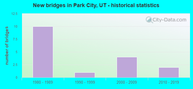
- New bridges - historical statistics
- 101980-1989
- 11990-1999
- 42000-2009
- 22010-2019
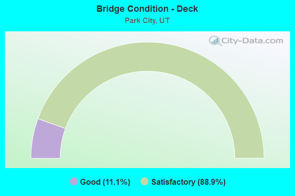
- Bridge Condition - Deck
- 11.1%Good
- 88.9%Satisfactory
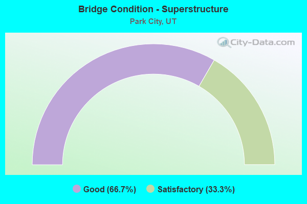
- Bridge Condition - Superstructure
- 66.7%Good
- 33.3%Satisfactory
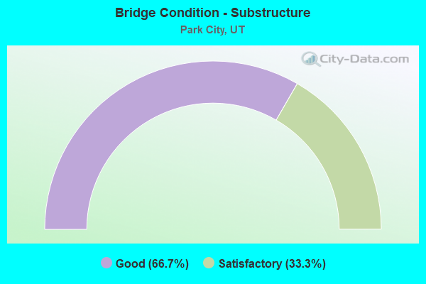
- Bridge Condition - Substructure
- 66.7%Good
- 33.3%Satisfactory
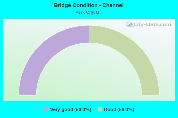
- Bridge Condition - Channel
- 50.0%Very good
- 50.0%Good
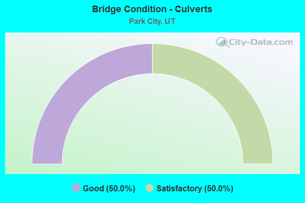
- Bridge Condition - Culverts
- 50.0%Good
- 50.0%Satisfactory
Find on map >> Show street view
Structure Number: 43019D, Location: AT ENT.TO DEER VALLEY LDG (Lat: 40.638164, Lng: -111.478900), Route carried "on" structure: ServiceCity street , Year Built: 1996, Status: Open, Structure Length: 4.69m (15.39ft), Average Daily Traffic: 2,350 (year 2020), Truck Traffic: 1%, Average Future Daily Traffic: 2,855 (year 2040), Design Load: HL 93, Features Intersected: DEER VALLEY LODGE ENT., Facility Carried by Structure: DEER VALLEY DRIVE
Minimum Vertical Clearance: 30+ m (98+ ft), Kilometerpoint: 0.086, Lanes on structure: 2, Lanes under structure: 2, Owner: City or Municipal Highway Agency, Approaching Roadway Width: 10.4m (34.1ft), Material/Design: Concrete, Design/Construction: Slab, Number Of Spans In Main Unit: 7, Length of Maximum Span: 6.7m (22.0ft), Curb or Sidewalk Widths: Left: 1.8m (5.9ft), Right: 1.8m (5.9ft), Curb-To-Curb Width: 13.6m (44.6ft), Out-to-Out Width: 32.0m (105.0ft)
Condition: Deck: Satisfactory, Superstructure: Satisfactory, Substructure: Good, Operating Rating: 32.4 metric tons, Method Used To Determine Operating Rating: Load and Resistance Factor Rating (LRFR) rating reported by rating factor(RF) method using HL-93 loadings, Inventory Rating: 19.4 metric tons, Method Used To Determine Inventory Rating: Load Factor (LF) rating reported by rating factor (RF) method using MS18 loading, Structural Evaluation: Somewhat better than minimum adequacy, Deck Geometry: Superior to present desirable criteria, Underclear: High priority of corrective action, Approach Roadway Alignment: Meets minimum limits, Designated Inspection Frequency: Every 25 months, Inspection Date: May 2020, Deck Structure Type: Concrete Cast-file-Place, Wearing Surface/Protective System: Wearing Surface: Bituminous, Deck Protection: Epoxy Coated Reinforcing
Find on map >> Show street view
Structure Number: C 95, Location: On Guardsman Pass Road (Lat: 40.607892, Lng: -111.507383), Route carried "on" structure: ServiceCity street , Year Built: 2008, Status: Open, Structure Length: 2.03m (6.66ft), Average Daily Traffic: 2,000 (year 2020), Average Future Daily Traffic: 2,500 (year 2040), Design Load: HS 20+Mod, Features Intersected: SR-224,GUARDSMAN PASS, Facility Carried by Structure: SUBDVN.ACCESS ROAD
Minimum Vertical Clearance: 30+ m (98+ ft), Kilometerpoint: 0.005, Lanes on structure: 2, Lanes under structure: 2, Owner: State Highway Agency, Approaching Roadway Width: 9.8m (32.2ft), Skew: 3 degrees, Material/Design: Steel, Design/Construction: Stringer/Multi-beam, Number Of Spans In Main Unit: 1, Length of Maximum Span: 18.3m (60.0ft), Curb-To-Curb Width: 11.9m (39.0ft), Out-to-Out Width: 12.8m (42.0ft)
Condition: Deck: Satisfactory, Superstructure: Good, Substructure: Satisfactory, Operating Rating: 58.0 metric tons, Method Used To Determine Operating Rating: Load and Resistance Factor Rating (LRFR) rating reported by rating factor(RF) method using HL-93 loadings, Inventory Rating: 42.1 metric tons, Method Used To Determine Inventory Rating: Load Factor (LF) rating reported by rating factor (RF) method using MS18 loading, Structural Evaluation: Equal to present minimum criteria, Deck Geometry: Equal to present minimum criteria, Underclear: Equal to present desirable criteria, Approach Roadway Alignment: Equal to present desirable criteria, Designated Inspection Frequency: Every 24 months, Inspection Date: August 2020, Deck Structure Type: Concrete Cast-file-Place, Wearing Surface/Protective System: Wearing Surface: Bituminous, Membrane: Preformed Fabric, Deck Protection: Epoxy Coated Reinforcing
Find on map >> Show street view
Structure Number: D 838, Location: DEER VALLEY @ FLAGSTAFF (Lat: 40.619689, Lng: -111.507342), Route carried "on" structure: State highway 224, Year Built: 2003, Status: Open, Structure Length: 0.99m (3.25ft), Average Daily Traffic: 4,653 (year 2020), Truck Traffic: 16%, Average Future Daily Traffic: 5,816 (year 2040), Design Load: HS 20+Mod, Features Intersected: DEER VALLEY SKI RUN
Minimum Vertical Clearance: 30+ m (98+ ft), Kilometerpoint: 2.342, Lanes on structure: 2, Owner: State Highway Agency, Approaching Roadway Width: 8.8m (28.9ft), Material/Design: Concrete, Design/Construction: Frame, Number Of Spans In Main Unit: 1, Length of Maximum Span: 9.1m (29.9ft), Curb-To-Curb Width: 8.8m (28.9ft), Out-to-Out Width: 13.8m (45.3ft)
Condition: Deck: Good, Superstructure: Good, Substructure: Good, Operating Rating: 32.4 metric tons, Method Used To Determine Operating Rating: Load and Resistance Factor Rating (LRFR) rating reported by rating factor(RF) method using HL-93 loadings, Inventory Rating: 21.1 metric tons, Method Used To Determine Inventory Rating: Load Factor (LF) rating reported by rating factor (RF) method using MS18 loading, Structural Evaluation: Somewhat better than minimum adequacy, Deck Geometry: Meets minimum limits, Approach Roadway Alignment: Equal to present desirable criteria, Designated Inspection Frequency: Every 24 months, Inspection Date: August 2020, Deck Structure Type: Concrete Precast Panels, Wearing Surface/Protective System: Wearing Surface: Bituminous
Find on map >> Show street view
Structure Number: 2C 754, Location: EAST PARK CITY INTERCHG. (Lat: 40.683492, Lng: -111.462536), Route carried "on" structure: US 40, Year Built: 1989, Status: Open, Structure Length: 6.33m (20.77ft), Average Daily Traffic: 33,813 (year 2020), Truck Traffic: 27%, Average Future Daily Traffic: 42,266 (year 2040), Design Load: HS 20+Mod, Features Intersected: SR-248, INTCHG. X-RD
Minimum Vertical Clearance: 30+ m (98+ ft), Kilometerpoint: 6.443, Lanes on structure: 2, Lanes under structure: 5, Base Highway Network: Yes, Owner: State Highway Agency, Approaching Roadway Width: 11.6m (38.1ft), Material/Design: Steel continuous, Design/Construction: Stringer/Multi-beam, Number Of Spans In Main Unit: 3, Length of Maximum Span: 44.2m (145.0ft), Curb-To-Curb Width: 12.4m (40.7ft), Out-to-Out Width: 13.4m (44.0ft)
Condition: Deck: Satisfactory, Superstructure: Satisfactory, Substructure: Good, Operating Rating: 76.8 metric tons, Method Used To Determine Operating Rating: Load and Resistance Factor Rating (LRFR) rating reported by rating factor(RF) method using HL-93 loadings, Inventory Rating: 58.0 metric tons, Method Used To Determine Inventory Rating: Load Factor (LF) rating reported by rating factor (RF) method using MS18 loading, Structural Evaluation: Equal to present minimum criteria, Deck Geometry: Better than present minimum criteria, Underclear: Better than present minimum criteria, Approach Roadway Alignment: Equal to present desirable criteria, Designated Inspection Frequency: Every 24 months, Inspection Date: August 2020, Deck Structure Type: Concrete Cast-file-Place, Wearing Surface/Protective System: Wearing Surface: Epoxy Overlay, Deck Protection: Epoxy Coated Reinforcing
Find on map >> Show street view
Structure Number: 2F 463, Location: .4 MI.SE.PARK CITY INTCHG (Lat: 40.677714, Lng: -111.461228), Route carried "on" structure: US 40, Year Built: 1989, Year Reconstructed: 2015, Status: Open, Structure Length: 7.27m (23.85ft), Average Daily Traffic: 26,188 (year 2020), Truck Traffic: 22%, Average Future Daily Traffic: 32,735 (year 2040), Design Load: HS 20+Mod, Features Intersected: SILVER CREEK AND ABD.R
Minimum Vertical Clearance: 30+ m (98+ ft), Kilometerpoint: 7.095, Lanes on structure: 3, Base Highway Network: Yes, Owner: State Highway Agency, Approaching Roadway Width: 17.7m (58.1ft), Skew: 4 degrees, Material/Design: Prestressed concrete continuous, Design/Construction: Stringer/Multi-beam, Number Of Spans In Main Unit: 3, Length of Maximum Span: 36.0m (118.1ft), Curb-To-Curb Width: 16.0m (52.5ft), Out-to-Out Width: 18.6m (61.0ft)
Condition: Deck: Satisfactory, Superstructure: Satisfactory, Substructure: Satisfactory, Channel: Very good, Operating Rating: 55.7 metric tons, Method Used To Determine Operating Rating: Load and Resistance Factor Rating (LRFR) rating reported by rating factor(RF) method using HL-93 loadings, Inventory Rating: 41.8 metric tons, Method Used To Determine Inventory Rating: Load Factor (LF) rating reported by rating factor (RF) method using MS18 loading, Structural Evaluation: Equal to present minimum criteria, Deck Geometry: Equal to present minimum criteria, Waterway Adequacy: Equal to present desirable criteria, Approach Roadway Alignment: Equal to present desirable criteria, Designated Inspection Frequency: Every 24 months, Inspection Date: August 2020, Deck Structure Type: Concrete Cast-file-Place, Wearing Surface/Protective System: Wearing Surface: Epoxy Overlay, Deck Protection: Epoxy Coated Reinforcing
Find on map >> Show street view
Structure Number: 2F 54, Location: .7 MI.SE.PARK CITY INTCHG (Lat: 40.673822, Lng: -111.460600), Route carried "on" structure: US 40, Year Built: 1989, Year Reconstructed: 2015, Status: Open, Structure Length: 3.29m (10.79ft), Average Daily Traffic: 26,188 (year 2020), Truck Traffic: 22%, Average Future Daily Traffic: 32,735 (year 2040), Design Load: HS 20+Mod, Features Intersected: LOCAL COUNTY ROAD
Minimum Vertical Clearance: 30+ m (98+ ft), Kilometerpoint: 7.530, Lanes on structure: 2, Lanes under structure: 2, Base Highway Network: Yes, Owner: State Highway Agency, Approaching Roadway Width: 11.6m (38.1ft), Skew: 1 degrees, Material/Design: Prestressed concrete, Design/Construction: Stringer/Multi-beam, Number Of Spans In Main Unit: 1, Length of Maximum Span: 32.2m (105.6ft), Curb-To-Curb Width: 12.4m (40.7ft), Out-to-Out Width: 13.5m (44.3ft)
Condition: Deck: Satisfactory, Superstructure: Good, Substructure: Satisfactory, Operating Rating: 41.5 metric tons, Method Used To Determine Operating Rating: Load and Resistance Factor Rating (LRFR) rating reported by rating factor(RF) method using HL-93 loadings, Inventory Rating: 32.7 metric tons, Method Used To Determine Inventory Rating: Load and Resistance Factor Rating (LRFR) rating reported by rating factor(RF) method using HL-93 loadings, Structural Evaluation: Equal to present minimum criteria, Deck Geometry: Better than present minimum criteria, Underclear: Better than present minimum criteria, Approach Roadway Alignment: Equal to present desirable criteria, Designated Inspection Frequency: Every 24 months, Inspection Date: August 2020, Deck Structure Type: Concrete Cast-file-Place, Wearing Surface/Protective System: Wearing Surface: Epoxy Overlay, Deck Protection: Epoxy Coated Reinforcing
Find on map >> Show street view
Structure Number: 2V1722, Location: .8 Mi E of Silver Creek (Lat: 40.707461, Lng: -111.479225), Route carried "on" structure: US 40, Year Built: 2015, Status: Open, Structure Length: 0.78m (2.56ft), Average Daily Traffic: 33,813 (year 2020), Truck Traffic: 27%, Average Future Daily Traffic: 42,266 (year 2040), Design Load: HL 93, Features Intersected: Ped / Wildlife Trail
Minimum Vertical Clearance: 30+ m (98+ ft), Kilometerpoint: 3.428, Lanes on structure: 2, Base Highway Network: Yes, Owner: State Highway Agency, Approaching Roadway Width: 11.6m (38.1ft), Material/Design: Concrete, Design/Construction: Culvert, Number Of Spans In Main Unit: 1, Length of Maximum Span: 7.3m (24.0ft)
Condition: Culverts: Satisfactory, Operating Rating: 49.6 metric tons, Method Used To Determine Operating Rating: Load and Resistance Factor Rating (LRFR) rating reported by rating factor(RF) method using HL-93 loadings, Inventory Rating: 40.8 metric tons, Method Used To Determine Inventory Rating: Load and Resistance Factor Rating (LRFR) rating reported by rating factor(RF) method using HL-93 loadings, Structural Evaluation: Equal to present minimum criteria, Approach Roadway Alignment: Superior to present desirable criteria, Designated Inspection Frequency: Every 24 months, Inspection Date: August 2020
Find on map >> Show street view
Structure Number: 4C 754, Location: EAST PARK CITY INTERCHG. (Lat: 40.682931, Lng: -111.461961), Route carried "on" structure: US 40, Year Built: 1989, Year Reconstructed: 2016, Status: Open, Structure Length: 6.33m (20.77ft), Average Daily Traffic: 33,813 (year 2020), Truck Traffic: 27%, Average Future Daily Traffic: 42,266 (year 2040), Design Load: HS 20+Mod, Features Intersected: SR-248, INTCHG. X-RD
Minimum Vertical Clearance: 30+ m (98+ ft), Kilometerpoint: 6.155, Lanes on structure: 2, Lanes under structure: 5, Base Highway Network: Yes, Owner: State Highway Agency, Approaching Roadway Width: 11.6m (38.1ft), Material/Design: Steel continuous, Design/Construction: Stringer/Multi-beam, Number Of Spans In Main Unit: 3, Length of Maximum Span: 44.2m (145.0ft), Curb-To-Curb Width: 12.4m (40.7ft), Out-to-Out Width: 13.5m (44.3ft)
Condition: Deck: Satisfactory, Superstructure: Good, Substructure: Good, Operating Rating: 77.1 metric tons, Method Used To Determine Operating Rating: Load and Resistance Factor Rating (LRFR) rating reported by rating factor(RF) method using HL-93 loadings, Inventory Rating: 58.0 metric tons, Method Used To Determine Inventory Rating: Load Factor (LF) rating reported by rating factor (RF) method using MS18 loading, Structural Evaluation: Better than present minimum criteria, Deck Geometry: Better than present minimum criteria, Underclear: Better than present minimum criteria, Approach Roadway Alignment: Better than present minimum criteria, Designated Inspection Frequency: Every 24 months, Inspection Date: August 2020, Deck Structure Type: Concrete Cast-file-Place, Wearing Surface/Protective System: Wearing Surface: Epoxy Overlay, Deck Protection: Epoxy Coated Reinforcing
Find on map >> Show street view
Structure Number: 4F 463, Location: .4 MI.SE.PARK CITY INTCHG (Lat: 40.677250, Lng: -111.460811), Route carried "on" structure: US 40, Year Built: 1989, Status: Open, Structure Length: 7.27m (23.85ft), Average Daily Traffic: 26,188 (year 2020), Truck Traffic: 22%, Average Future Daily Traffic: 32,735 (year 2040), Design Load: HS 20+Mod, Features Intersected: SILVER CREEK & ABD.R
Minimum Vertical Clearance: 30+ m (98+ ft), Kilometerpoint: 6.794, Lanes on structure: 2, Base Highway Network: Yes, Owner: State Highway Agency, Approaching Roadway Width: 11.6m (38.1ft), Skew: 4 degrees, Material/Design: Prestressed concrete continuous, Design/Construction: Stringer/Multi-beam, Number Of Spans In Main Unit: 3, Length of Maximum Span: 36.0m (118.1ft), Curb-To-Curb Width: 12.4m (40.7ft), Out-to-Out Width: 13.5m (44.3ft)
Condition: Deck: Satisfactory, Superstructure: Good, Substructure: Good, Channel: Good, Operating Rating: 45.0 metric tons, Method Used To Determine Operating Rating: Load and Resistance Factor Rating (LRFR) rating reported by rating factor(RF) method using HL-93 loadings, Inventory Rating: 30.5 metric tons, Method Used To Determine Inventory Rating: Load and Resistance Factor Rating (LRFR) rating reported by rating factor(RF) method using HL-93 loadings, Structural Evaluation: Better than present minimum criteria, Deck Geometry: Better than present minimum criteria, Waterway Adequacy: Superior to present desirable criteria, Approach Roadway Alignment: Equal to present desirable criteria, Designated Inspection Frequency: Every 24 months, Inspection Date: August 2020, Deck Structure Type: Concrete Cast-file-Place, Wearing Surface/Protective System: Wearing Surface: Epoxy Overlay, Deck Protection: Epoxy Coated Reinforcing
Find on map >> Show street view
Structure Number: 4F 54, Location: .7 MI.SE.PARK CITY INTCHG (Lat: 40.673367, Lng: -111.460183), Route carried "on" structure: US 40, Year Built: 1989, Year Reconstructed: 2016, Status: Open, Structure Length: 3.29m (10.79ft), Average Daily Traffic: 26,188 (year 2020), Truck Traffic: 22%, Average Future Daily Traffic: 32,735 (year 2040), Design Load: HS 20+Mod, Features Intersected: LOCAL COUNTY ROAD
Minimum Vertical Clearance: 30+ m (98+ ft), Kilometerpoint: 7.228, Lanes on structure: 2, Lanes under structure: 2, Base Highway Network: Yes, Owner: State Highway Agency, Approaching Roadway Width: 11.6m (38.1ft), Skew: 1 degrees, Material/Design: Prestressed concrete, Design/Construction: Stringer/Multi-beam, Number Of Spans In Main Unit: 1, Length of Maximum Span: 32.2m (105.6ft), Curb-To-Curb Width: 12.4m (40.7ft), Out-to-Out Width: 13.5m (44.3ft)
Condition: Deck: Satisfactory, Superstructure: Good, Substructure: Good, Operating Rating: 41.5 metric tons, Method Used To Determine Operating Rating: Load and Resistance Factor Rating (LRFR) rating reported by rating factor(RF) method using HL-93 loadings, Inventory Rating: 32.7 metric tons, Method Used To Determine Inventory Rating: Load and Resistance Factor Rating (LRFR) rating reported by rating factor(RF) method using HL-93 loadings, Structural Evaluation: Better than present minimum criteria, Deck Geometry: Better than present minimum criteria, Underclear: Better than present minimum criteria, Approach Roadway Alignment: Equal to present desirable criteria, Designated Inspection Frequency: Every 24 months, Inspection Date: August 2020, Deck Structure Type: Concrete Cast-file-Place, Wearing Surface/Protective System: Wearing Surface: Epoxy Overlay, Deck Protection: Epoxy Coated Reinforcing
Find on map >> Show street view
Structure Number: 4V1722, Location: 1.8 Mi E of Silver Creek (Lat: 40.707275, Lng: -111.478689), Route carried "on" structure: US 40, Year Built: 2015, Status: Open, Structure Length: 0.73m (2.40ft), Average Daily Traffic: 33,813 (year 2020), Truck Traffic: 27%, Average Future Daily Traffic: 42,266 (year 2040), Design Load: HL 93, Features Intersected: Ped / Wildlife Trail
Minimum Vertical Clearance: 30+ m (98+ ft), Kilometerpoint: 3.101, Lanes on structure: 2, Base Highway Network: Yes, Owner: State Highway Agency, Approaching Roadway Width: 11.6m (38.1ft), Material/Design: Concrete, Design/Construction: Culvert, Number Of Spans In Main Unit: 1, Length of Maximum Span: 7.3m (24.0ft)
Condition: Culverts: Good, Operating Rating: 49.6 metric tons, Method Used To Determine Operating Rating: Load and Resistance Factor Rating (LRFR) rating reported by rating factor(RF) method using HL-93 loadings, Inventory Rating: 40.8 metric tons, Method Used To Determine Inventory Rating: Load and Resistance Factor Rating (LRFR) rating reported by rating factor(RF) method using HL-93 loadings, Structural Evaluation: Better than present minimum criteria, Approach Roadway Alignment: Equal to present desirable criteria, Designated Inspection Frequency: Every 24 months, Inspection Date: August 2020
Find on map >> Show street view
Structure Number: C 938, Location: Deer Valley Ski Resort (Lat: 40.621186, Lng: -111.505286), Route carried "under" structure: State highway 224, Year Built: 2004, Structure Length: 0. m, Average Daily Traffic: 4,653 (year 2020), Truck Traffic: 16%, Features Intersected: SR-224, Facility Carried by Structure: DEER VLY. SKI RUN
Minimum Vertical Clearance: 4.92m (16.14ft), Kilometerpoint: 2.620, Lanes under structure: 2, Material/Design: Steel, Design/Construction: Stringer/Multi-beam, Length of Maximum Span: 13.5m (44.3ft)
Find on map >> Show street view
Structure Number: C 95, Location: On Guardsman Pass Road (Lat: 40.607892, Lng: -111.507383), Route carried "under" structure: State highway 224, Year Built: 2008, Structure Length: 0. m, Average Daily Traffic: 4,653 (year 2020), Truck Traffic: 16%, Features Intersected: SR-224,GUARDSMAN PASS, Facility Carried by Structure: SUBDVN.ACCESS ROAD
Minimum Vertical Clearance: 5.02m (16.47ft), Kilometerpoint: 0.644, Lanes on structure: 2, Lanes under structure: 2, Material/Design: Steel, Design/Construction: Stringer/Multi-beam, Length of Maximum Span: 18.3m (60.0ft)
Find on map >> Show street view
Structure Number: 2C 754, Location: EAST PARK CITY INTERCHG. (Lat: 40.683492, Lng: -111.462536), Route carried "under" structure: State highway 248, Year Built: 1989, Structure Length: 0. m, Average Daily Traffic: 17,428 (year 2020), Truck Traffic: 18%, Features Intersected: SR-248, INTCHG. X-RD, Facility Carried by Structure: US-40 (SR-40) EBL
Minimum Vertical Clearance: 5.13m (16.83ft), Kilometerpoint: 5.018, Lanes on structure: 2, Lanes under structure: 5, Material/Design: Steel continuous, Design/Construction: Stringer/Multi-beam, Length of Maximum Span: 44.2m (145.0ft)
Find on map >> Show street view
Structure Number: 2F 54, Location: .7 MI.SE.PARK CITY INTCHG (Lat: 40.673822, Lng: -111.460600), Route carried "under" structure: County highway , Year Built: 1989, Structure Length: 0. m, Features Intersected: LOCAL COUNTY ROAD, Facility Carried by Structure: US-40 (SR-40) EBL
Minimum Vertical Clearance: 4.95m (16.24ft), Kilometerpoint: 0.000, Lanes on structure: 2, Lanes under structure: 2, Material/Design: Prestressed concrete, Design/Construction: Stringer/Multi-beam, Length of Maximum Span: 32.2m (105.6ft)
Find on map >> Show street view
Structure Number: 4C 754, Location: EAST PARK CITY INTERCHG. (Lat: 40.682931, Lng: -111.461961), Route carried "under" structure: State highway 248, Year Built: 1989, Structure Length: 0. m, Average Daily Traffic: 10,980 (year 2020), Truck Traffic: 21%, Features Intersected: SR-248, INTCHG. X-RD, Facility Carried by Structure: US-40 (SR-40)WBL
Minimum Vertical Clearance: 5.78m (18.96ft), Kilometerpoint: 5.036, Lanes on structure: 2, Lanes under structure: 5, Material/Design: Steel continuous, Design/Construction: Stringer/Multi-beam, Length of Maximum Span: 44.2m (145.0ft)
Find on map >> Show street view
Structure Number: 4F 54, Location: .7 MI.SE.PARK CITY INTCHG (Lat: 40.673367, Lng: -111.460183), Route carried "under" structure: County highway , Year Built: 1989, Structure Length: 0. m, Average Daily Traffic: 50 (year 2020), Features Intersected: LOCAL COUNTY ROAD, Facility Carried by Structure: US-40 (SR-40) WBL
Minimum Vertical Clearance: 4.92m (16.14ft), Kilometerpoint: 0.000, Lanes on structure: 2, Lanes under structure: 2, Material/Design: Prestressed concrete, Design/Construction: Stringer/Multi-beam, Length of Maximum Span: 32.2m (105.6ft)