Bridge Statistics for Parryville, Pennsylvania (PA)
Condition, Traffic, Stress, Structural Evaluation, Project Costs
- National Bridge Inventory (NBI) Statistics
- 10Number of bridges
- 528ft / 161mTotal length
- $745,000Total costs
- 167,359Total average daily traffic
- 24,390Total average daily truck traffic
- National Bridge Inventory (NBI) Registered Bridges for Parryville
- No street view available for this location
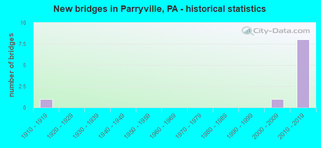
- New bridges - historical statistics
- 11910-1919
- 12000-2009
- 82010-2019


- Bridge Condition - Deck
- 16.7%Very good
- 66.7%Good
- 16.7%Fair

- Bridge Condition - Superstructure
- 16.7%Very good
- 66.7%Good
- 16.7%Fair

- Bridge Condition - Substructure
- 16.7%Very good
- 66.7%Good
- 16.7%Fair
Find on map >> Show street view
Structure Number: 4743, Location: SCHUYLKILL AVE (Lat: 40.353097, Lng: -75.946700), Route carried "on" structure: State highway 183, Year Built: 1912, Year Reconstructed: 1930, Status: Open, Structure Length: 2.65m (8.69ft), Average Daily Traffic: 15,418 (year 2020), Truck Traffic: 3%, Average Future Daily Traffic: 19,200 (year 2032), Design Load: HS 20, Features Intersected: NORFOLK SOUTHERN RR
Minimum Vertical Clearance: 30+ m (98+ ft), Kilometerpoint: 0.507, Lanes on structure: 4, Owner: Railroad, Maintenance Responsibility: State Highway Agency, Approaching Roadway Width: 14.6m (47.9ft), Skew: 1 degrees, Material/Design: Steel, Design/Construction: Stringer/Multi-beam, Number Of Spans In Main Unit: 3, Length of Maximum Span: 10.4m (34.1ft), Curb or Sidewalk Widths: Left: 3.1m (10.2ft), Right: 3.1m (10.2ft), Curb-To-Curb Width: 14.6m (47.9ft), Out-to-Out Width: 21.6m (70.9ft)
Condition: Deck: Fair, Superstructure: Fair, Substructure: Fair, Inventory Rating: 60.8 metric tons, Method Used To Determine Inventory Rating: Load Factor (LF), Structural Evaluation: Somewhat better than minimum adequacy, Deck Geometry: High priority of replacement, Underclear: High priority of corrective action, Approach Roadway Alignment: Better than present minimum criteria, Length Of Structure Improvement: 3.40m (11.15ft), Designated Inspection Frequency: Every 24 months, Inspection Date: December 2019, Bridge Improvement Cost: $55,000, Roadway Improvement Cost: $163,000, Total Project Cost: $745,000, Deck Structure Type: Concrete Cast-file-Place, Wearing Surface/Protective System: Wearing Surface: Bituminous
Find on map >> Show street view
Structure Number: 45655, Location: Parryville-Centre St. (Lat: 40.817372, Lng: -75.672786), Route carried "on" structure: State highway , Year Built: 2009, Status: Open, Structure Length: 2.44m (8.01ft), Average Daily Traffic: 247 (year 2022), Truck Traffic: 5%, Average Future Daily Traffic: 599 (year 2032), Design Load: HL 93, Features Intersected: Pohopoco Ck, Facility Carried by Structure: SR 2008
Minimum Vertical Clearance: 30.18m (99.02ft), Kilometerpoint: 0.000, Lanes on structure: 2, Owner: State Highway Agency, Approaching Roadway Width: 7.9m (25.9ft), Material/Design: Prestressed concrete, Design/Construction: Box Beam or Girders - Single/Spread, Number Of Spans In Main Unit: 1, Length of Maximum Span: 24.4m (80.1ft), Curb or Sidewalk Widths: Left: 1.5m (4.9ft), Right: 0.0m, Curb-To-Curb Width: 8.5m (27.9ft), Out-to-Out Width: 10.9m (35.8ft)
Condition: Deck: Very good, Superstructure: Very good, Substructure: Very good, Channel: Very good, Operating Rating: 70.8 metric tons, Method Used To Determine Operating Rating: Load and Resistance Factor (LRFR), Inventory Rating: 38.1 metric tons, Method Used To Determine Inventory Rating: Load and Resistance Factor (LRFR), Structural Evaluation: Equal to present desirable criteria, Deck Geometry: Equal to present minimum criteria, Waterway Adequacy: Superior to present desirable criteria, Approach Roadway Alignment: Equal to present desirable criteria, Designated Inspection Frequency: Every 48 months, Inspection Date: August 2018, Deck Structure Type: Concrete Cast-file-Place, Wearing Surface/Protective System: Wearing Surface: Monolithic Concrete, Deck Protection: Epoxy Coated Reinforcing
Find on map >> Show street view
Structure Number: 47428, Location: Parryville Boro (Lat: 40.818642, Lng: -75.677175), Route carried "on" structure: Interstate 476, Year Built: 2012, Status: Open, Structure Length: 47.15m (154.69ft), Average Daily Traffic: 24,228 (year 2004), Truck Traffic: 20%, Average Future Daily Traffic: 32,159 (year 2030), Design Load: HL 93, Features Intersected: LVRR, Lehigh R, PA 248,
Minimum Vertical Clearance: 30+ m (98+ ft), Kilometerpoint: 0.000, Lanes on structure: 2, Lanes under structure: 4, Base Highway Network: Yes, Toll: On toll road, Owner: State Toll Authority, Approaching Roadway Width: 12.8m (42.0ft), Skew: 30 degrees, Material/Design: Prestressed concrete continuous, Design/Construction: Stringer/Multi-beam, Number Of Spans In Main Unit: 10, Length of Maximum Span: 51.2m (168.0ft), Curb or Sidewalk Widths: Left: 0.2m (0.7ft), Right: 0.2m (0.7ft), Curb-To-Curb Width: 12.8m (42.0ft), Out-to-Out Width: 13.8m (45.3ft)
Condition: Deck: Good, Superstructure: Good, Substructure: Good, Channel: Very good, Operating Rating: 51.8 metric tons, Method Used To Determine Operating Rating: Assigned ratings based on Load and Resistance Factor Design (LRFD) reported by rating factor (RF) using HL93 loadings, Inventory Rating: 32.4 metric tons, Method Used To Determine Inventory Rating: Assigned ratings based on Load and Resistance Factor Design (LRFD) reported by rating factor (RF) using HL93 loadings, Structural Evaluation: Better than present minimum criteria, Deck Geometry: Equal to present desirable criteria, Underclear: Meets minimum limits, Waterway Adequacy: Superior to present desirable criteria, Approach Roadway Alignment: Equal to present desirable criteria, Designated Inspection Frequency: Every 48 months, Underwater Inspection Frequency: Every 60 months, Inspection Date: September 2018, Underwater Inspection Date: October 2018, Deck Structure Type: Concrete Cast-file-Place, Wearing Surface/Protective System: Wearing Surface: Monolithic Concrete, Deck Protection: Epoxy Coated Reinforcing
Find on map >> Show street view
Structure Number: 47429, Location: Parryville Boro (Lat: 40.818856, Lng: -75.677325), Route carried "on" structure: Interstate 476, Year Built: 2012, Status: Open, Structure Length: 46.06m (151.12ft), Average Daily Traffic: 24,228 (year 2004), Truck Traffic: 20%, Average Future Daily Traffic: 32,159 (year 2030), Design Load: HL 93, Features Intersected: LVRR, Lehigh R, PA 248,
Minimum Vertical Clearance: 5.83m (19.13ft), Kilometerpoint: 0.000, Lanes on structure: 2, Lanes under structure: 4, Base Highway Network: Yes, Toll: On toll road, Owner: State Toll Authority, Approaching Roadway Width: 13.7m (44.9ft), Skew: 10 degrees, Material/Design: Prestressed concrete continuous, Design/Construction: Stringer/Multi-beam, Number Of Spans In Main Unit: 11, Length of Maximum Span: 49.7m (163.1ft), Curb or Sidewalk Widths: Left: 0.2m (0.7ft), Right: 0.2m (0.7ft), Curb-To-Curb Width: 13.7m (44.9ft), Out-to-Out Width: 13.8m (45.3ft)
Condition: Deck: Good, Superstructure: Good, Substructure: Good, Channel: Very good, Operating Rating: 51.8 metric tons, Method Used To Determine Operating Rating: Assigned ratings based on Load and Resistance Factor Design (LRFD) reported by rating factor (RF) using HL93 loadings, Inventory Rating: 32.7 metric tons, Method Used To Determine Inventory Rating: Assigned ratings based on Load and Resistance Factor Design (LRFD) reported by rating factor (RF) using HL93 loadings, Structural Evaluation: Better than present minimum criteria, Deck Geometry: Superior to present desirable criteria, Underclear: Meets minimum limits, Waterway Adequacy: Superior to present desirable criteria, Approach Roadway Alignment: Equal to present desirable criteria, Designated Inspection Frequency: Every 48 months, Underwater Inspection Frequency: Every 60 months, Inspection Date: September 2018, Underwater Inspection Date: October 2018, Deck Structure Type: Concrete Cast-file-Place, Wearing Surface/Protective System: Wearing Surface: Integral Concrete, Deck Protection: Epoxy Coated Reinforcing
Find on map >> Show street view
Structure Number: 4743, Location: Parryville (Lat: 40.823147, Lng: -75.678250), Route carried "on" structure: Interstate 476, Year Built: 2012, Status: Open, Structure Length: 31.33m (102.79ft), Average Daily Traffic: 30,509 (year 2010), Truck Traffic: 17%, Average Future Daily Traffic: 81,900 (year 2030), Design Load: HS 20, Features Intersected: Pohopoco Cr &LowerMainSt
Minimum Vertical Clearance: 30+ m (98+ ft), Kilometerpoint: 0.000, Lanes on structure: 2, Base Highway Network: Yes, Toll: On toll road, Owner: State Toll Authority, Approaching Roadway Width: 13.7m (44.9ft), Skew: 10 degrees, Material/Design: Prestressed concrete continuous, Design/Construction: Stringer/Multi-beam, Number Of Spans In Main Unit: 7, Length of Maximum Span: 50.3m (165.0ft), Curb or Sidewalk Widths: Left: 0.2m (0.7ft), Right: 0.2m (0.7ft), Curb-To-Curb Width: 13.7m (44.9ft), Out-to-Out Width: 13.9m (45.6ft)
Condition: Deck: Good, Superstructure: Good, Substructure: Good, Channel: Very good, Operating Rating: 77.1 metric tons, Method Used To Determine Operating Rating: Assigned ratings based on Load and Resistance Factor Design (LRFD) reported in metric tons, Inventory Rating: 46.3 metric tons, Method Used To Determine Inventory Rating: Assigned ratings based on Load and Resistance Factor Design (LRFD) reported in metric tons, Structural Evaluation: Better than present minimum criteria, Deck Geometry: Superior to present desirable criteria, Waterway Adequacy: Superior to present desirable criteria, Approach Roadway Alignment: Equal to present desirable criteria, Designated Inspection Frequency: Every 48 months, Underwater Inspection Frequency: Every 60 months, Inspection Date: September 2018, Underwater Inspection Date: August 2018, Deck Structure Type: Concrete Cast-file-Place, Wearing Surface/Protective System: Wearing Surface: Monolithic Concrete, Deck Protection: Epoxy Coated Reinforcing
Find on map >> Show street view
Structure Number: 47431, Location: Parryville (Lat: 40.823294, Lng: -75.678250), Route carried "on" structure: Other road 476, Year Built: 2012, Status: Open, Structure Length: 31.33m (102.79ft), Average Daily Traffic: 39,509 (year 2010), Truck Traffic: 17%, Average Future Daily Traffic: 81,900 (year 2030), Design Load: HS 20, Features Intersected: Pohopoco Cr &LowerMainSt
Minimum Vertical Clearance: 30+ m (98+ ft), Kilometerpoint: 0.000, Lanes on structure: 2, Base Highway Network: Yes, Toll: On toll road, Owner: State Toll Authority, Approaching Roadway Width: 12.8m (42.0ft), Skew: 10 degrees, Material/Design: Prestressed concrete continuous, Design/Construction: Stringer/Multi-beam, Number Of Spans In Main Unit: 7, Length of Maximum Span: 50.3m (165.0ft), Curb or Sidewalk Widths: Left: 0.2m (0.7ft), Right: 0.2m (0.7ft), Curb-To-Curb Width: 12.8m (42.0ft), Out-to-Out Width: 13.9m (45.6ft)
Condition: Deck: Good, Superstructure: Good, Substructure: Good, Channel: Very good, Operating Rating: 77.1 metric tons, Method Used To Determine Operating Rating: Assigned ratings based on Load and Resistance Factor Design (LRFD) reported in metric tons, Inventory Rating: 46.3 metric tons, Method Used To Determine Inventory Rating: Assigned ratings based on Load and Resistance Factor Design (LRFD) reported in metric tons, Structural Evaluation: Better than present minimum criteria, Deck Geometry: Somewhat better than minimum adequacy, Waterway Adequacy: Superior to present desirable criteria, Approach Roadway Alignment: Equal to present desirable criteria, Designated Inspection Frequency: Every 48 months, Underwater Inspection Frequency: Every 60 months, Inspection Date: September 2018, Underwater Inspection Date: August 2018, Deck Structure Type: Concrete Cast-file-Place, Wearing Surface/Protective System: Wearing Surface: Monolithic Concrete, Deck Protection: Epoxy Coated Reinforcing
Find on map >> Show street view
Structure Number: 47428, Location: Parryville Boro (Lat: 40.818642, Lng: -75.677175), Route carried "under" structure: State highway 248, Year Built: 2012, Structure Length: 0. m, Average Daily Traffic: 8,237 (year 2020), Truck Traffic: 7%, Features Intersected: LVRR, Lehigh R, PA 248,, Facility Carried by Structure: PA TPK (I-476 NB)
Minimum Vertical Clearance: 6.01m (19.72ft), Kilometerpoint: 1.183, Lanes on structure: 2, Lanes under structure: 2, Material/Design: Prestressed concrete continuous, Design/Construction: Stringer/Multi-beam, Length of Maximum Span: 51.2m (168.0ft)
Find on map >> Show street view
Structure Number: 47428, Location: Parryville Boro (Lat: 40.818642, Lng: -75.677175), Route carried "under" structure: State highway 248, Year Built: 2012, Structure Length: 0. m, Average Daily Traffic: 8,373 (year 2020), Truck Traffic: 7%, Features Intersected: LVRR, Lehigh R, PA 248,, Facility Carried by Structure: PA TPK (I-476 NB)
Minimum Vertical Clearance: 6.05m (19.85ft), Kilometerpoint: 1.199, Lanes on structure: 2, Lanes under structure: 2, Material/Design: Prestressed concrete continuous, Design/Construction: Stringer/Multi-beam, Length of Maximum Span: 51.2m (168.0ft)
Find on map >> Show street view
Structure Number: 47429, Location: Parryville Boro (Lat: 40.818856, Lng: -75.677325), Route carried "under" structure: State highway 248, Year Built: 2012, Structure Length: 0. m, Average Daily Traffic: 8,237 (year 2020), Truck Traffic: 7%, Features Intersected: LVRR, Lehigh R, PA 248,, Facility Carried by Structure: PA TPK (I-476 SB)
Minimum Vertical Clearance: 5.98m (19.62ft), Kilometerpoint: 1.183, Lanes on structure: 2, Lanes under structure: 2, Material/Design: Prestressed concrete continuous, Design/Construction: Stringer/Multi-beam, Length of Maximum Span: 49.7m (163.1ft)
Find on map >> Show street view
Structure Number: 47429, Location: Parryville Boro (Lat: 40.818856, Lng: -75.677325), Route carried "under" structure: State highway 248, Year Built: 2012, Structure Length: 0. m, Average Daily Traffic: 8,373 (year 2020), Truck Traffic: 7%, Features Intersected: LVRR, Lehigh R, PA 248,, Facility Carried by Structure: PA TPK (I-476 SB)
Minimum Vertical Clearance: 6.04m (19.82ft), Kilometerpoint: 1.199, Lanes on structure: 2, Lanes under structure: 2, Material/Design: Prestressed concrete continuous, Design/Construction: Stringer/Multi-beam, Length of Maximum Span: 49.7m (163.1ft)