Bridge Statistics for Perry, Ohio (OH)
Condition, Traffic, Stress, Structural Evaluation, Project Costs
- National Bridge Inventory (NBI) Statistics
- 15Number of bridges
- 420ft / 128mTotal length
- 193,148Total average daily traffic
- 33,683Total average daily truck traffic
- National Bridge Inventory (NBI) Registered Bridges for Perry
- No street view available for this location
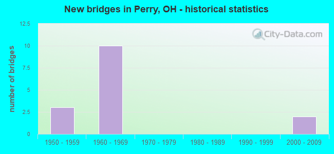
- New bridges - historical statistics
- 31950-1959
- 101960-1969
- 22000-2009

- Reconstructed bridges - Historical Statistics
- 21990-1999
- 12000-2009


- Bridge Condition - Deck
- 36.4%Very good
- 45.5%Good
- 9.1%Satisfactory
- 9.1%Poor

- Bridge Condition - Superstructure
- 63.6%Very good
- 9.1%Good
- 18.2%Satisfactory
- 9.1%Poor

- Bridge Condition - Substructure
- 54.5%Very good
- 18.2%Good
- 18.2%Satisfactory
- 9.1%Fair

- Bridge Condition - Channel
- 57.1%Very good
- 14.3%Good
- 28.6%Satisfactory
Find on map >> Show street view
Structure Number: 4302346, Location: 2.3 MI E GRAND RIVER (Lat: 41.755300, Lng: -81.197731), Route carried "on" structure: US 20, Year Built: 1966, Year Reconstructed: 1990, Status: Open, Structure Length: 8.17m (26.80ft), Average Daily Traffic: 27,428 (year 2015), Truck Traffic: 10%, Average Future Daily Traffic: 38,070 (year 2035), Design Load: HS 20+Mod, Features Intersected: SR-2 EB (LAK-2-1866R)
Minimum Vertical Clearance: 30+ m (98+ ft), Kilometerpoint: 31.205, Lanes on structure: 2, Lanes under structure: 2, Owner: State Highway Agency, Approaching Roadway Width: 12.8m (42.0ft), Skew: 5 degrees, Material/Design: Steel continuous, Design/Construction: Stringer/Multi-beam, Number Of Spans In Main Unit: 3, Length of Maximum Span: 30.5m (100.1ft), Curb or Sidewalk Widths: Left: 1.5m (4.9ft), Right: 1.5m (4.9ft), Curb-To-Curb Width: 15.9m (52.2ft), Out-to-Out Width: 19.5m (64.0ft)
Condition: Deck: Good, Superstructure: Good, Substructure: Satisfactory, Operating Rating: 42.1 metric tons, Method Used To Determine Operating Rating: Allowable Stress (AS) rating reported by rating factor (RF) method using MS18 loading, Inventory Rating: 32.4 metric tons, Method Used To Determine Inventory Rating: Allowable Stress (AS) rating reported by rating factor (RF) method using MS18 loading, Structural Evaluation: Equal to present minimum criteria, Deck Geometry: Superior to present desirable criteria, Underclear: High priority of corrective action, Approach Roadway Alignment: Equal to present desirable criteria, Designated Inspection Frequency: Every 12 months, Inspection Date: March 2021, Deck Structure Type: Concrete Cast-file-Place, Wearing Surface/Protective System: Wearing Surface: Monolithic Concrete
Find on map >> Show street view
Structure Number: 4304748, Location: 4.3 MI E RAVENNA RD (Lat: 41.715469, Lng: -81.163461), Route carried "on" structure: Interstate 90, Year Built: 1960, Status: Open, Structure Length: 14.87m (48.79ft), Average Daily Traffic: 18,883 (year 2015), Truck Traffic: 18%, Average Future Daily Traffic: 26,210 (year 2035), Design Load: HS 20+Mod, Features Intersected: PAINE CREEK @ MP 206.2
Minimum Vertical Clearance: 30+ m (98+ ft), Kilometerpoint: 32.235, Lanes on structure: 2, Base Highway Network: Yes, Owner: State Highway Agency, Approaching Roadway Width: 14.3m (46.9ft), Skew: 3 degrees, Material/Design: Steel continuous, Design/Construction: Stringer/Multi-beam, Number Of Spans In Main Unit: 3, Length of Maximum Span: 57.3m (188.0ft), Curb-To-Curb Width: 13.4m (44.0ft), Out-to-Out Width: 14.3m (46.9ft)
Condition: Deck: Very good, Superstructure: Very good, Substructure: Very good, Channel: Satisfactory, Operating Rating: 42.1 metric tons, Method Used To Determine Operating Rating: Allowable Stress (AS) rating reported by rating factor (RF) method using MS18 loading, Inventory Rating: 32.4 metric tons, Method Used To Determine Inventory Rating: Allowable Stress (AS) rating reported by rating factor (RF) method using MS18 loading, Structural Evaluation: Equal to present desirable criteria, Deck Geometry: Superior to present desirable criteria, Waterway Adequacy: Meets minimum limits, Approach Roadway Alignment: Equal to present desirable criteria, Designated Inspection Frequency: Every 24 months, Inspection Date: October 2021, Deck Structure Type: Concrete Cast-file-Place, Wearing Surface/Protective System: Wearing Surface: Monolithic Concrete
Find on map >> Show street view
Structure Number: 4304772, Location: 4.3 MI E RAVENNA RD (Lat: 41.715489, Lng: -81.162419), Route carried "on" structure: Interstate 90, Year Built: 1960, Status: Open, Structure Length: 15.12m (49.61ft), Average Daily Traffic: 18,883 (year 2015), Truck Traffic: 18%, Average Future Daily Traffic: 26,210 (year 2035), Design Load: HS 20+Mod, Features Intersected: PAINE CREEK @ MP 206.2
Minimum Vertical Clearance: 30+ m (98+ ft), Kilometerpoint: 32.235, Lanes on structure: 2, Base Highway Network: Yes, Owner: State Highway Agency, Approaching Roadway Width: 14.3m (46.9ft), Skew: 3 degrees, Material/Design: Steel continuous, Design/Construction: Stringer/Multi-beam, Number Of Spans In Main Unit: 3, Length of Maximum Span: 57.3m (188.0ft), Curb-To-Curb Width: 13.4m (44.0ft), Out-to-Out Width: 14.3m (46.9ft)
Condition: Deck: Very good, Superstructure: Very good, Substructure: Very good, Channel: Satisfactory, Operating Rating: 42.1 metric tons, Method Used To Determine Operating Rating: Allowable Stress (AS) rating reported by rating factor (RF) method using MS18 loading, Inventory Rating: 32.4 metric tons, Method Used To Determine Inventory Rating: Allowable Stress (AS) rating reported by rating factor (RF) method using MS18 loading, Structural Evaluation: Equal to present desirable criteria, Deck Geometry: Superior to present desirable criteria, Waterway Adequacy: Meets minimum limits, Approach Roadway Alignment: Equal to present desirable criteria, Designated Inspection Frequency: Every 24 months, Inspection Date: October 2021, Deck Structure Type: Concrete Cast-file-Place, Wearing Surface/Protective System: Wearing Surface: Monolithic Concrete
Find on map >> Show street view
Structure Number: 4304802, Location: 5.3 MI E RAVENNA RD (Lat: 41.718819, Lng: -81.143811), Route carried "on" structure: Interstate 90, Year Built: 1960, Status: Open, Structure Length: 4.05m (13.29ft), Average Daily Traffic: 18,883 (year 2015), Truck Traffic: 18%, Average Future Daily Traffic: 26,210 (year 2035), Design Load: HS 20+Mod, Features Intersected: PAINE RD AT MP 207.2
Minimum Vertical Clearance: 30+ m (98+ ft), Kilometerpoint: 33.957, Lanes on structure: 2, Lanes under structure: 2, Base Highway Network: Yes, Owner: State Highway Agency, Approaching Roadway Width: 12.8m (42.0ft), Skew: 1 degrees, Material/Design: Steel continuous, Design/Construction: Stringer/Multi-beam, Number Of Spans In Main Unit: 3, Length of Maximum Span: 14.0m (45.9ft), Curb-To-Curb Width: 12.8m (42.0ft), Out-to-Out Width: 13.4m (44.0ft)
Condition: Deck: Very good, Superstructure: Very good, Substructure: Very good, Operating Rating: 42.1 metric tons, Method Used To Determine Operating Rating: Allowable Stress (AS) rating reported by rating factor (RF) method using MS18 loading, Inventory Rating: 32.4 metric tons, Method Used To Determine Inventory Rating: Allowable Stress (AS) rating reported by rating factor (RF) method using MS18 loading, Structural Evaluation: Equal to present desirable criteria, Deck Geometry: Equal to present desirable criteria, Underclear: Somewhat better than minimum adequacy, Approach Roadway Alignment: Equal to present desirable criteria, Designated Inspection Frequency: Every 24 months, Inspection Date: Febuary 2021, Deck Structure Type: Concrete Cast-file-Place, Wearing Surface/Protective System: Wearing Surface: Monolithic Concrete, Deck Protection: Epoxy Coated Reinforcing
Find on map >> Show street view
Structure Number: 4304837, Location: 5.3 MI E RAVENNA RD (Lat: 41.719250, Lng: -81.143411), Route carried "on" structure: Interstate 90, Year Built: 1960, Status: Open, Structure Length: 3.44m (11.29ft), Average Daily Traffic: 18,883 (year 2015), Truck Traffic: 19%, Average Future Daily Traffic: 26,210 (year 2035), Design Load: HS 20+Mod, Features Intersected: PAINE RD AT MP 207.2
Minimum Vertical Clearance: 30+ m (98+ ft), Kilometerpoint: 33.957, Lanes on structure: 2, Lanes under structure: 2, Base Highway Network: Yes, Owner: State Highway Agency, Approaching Roadway Width: 12.8m (42.0ft), Skew: 1 degrees, Material/Design: Steel continuous, Design/Construction: Stringer/Multi-beam, Number Of Spans In Main Unit: 3, Length of Maximum Span: 14.0m (45.9ft), Curb-To-Curb Width: 12.8m (42.0ft), Out-to-Out Width: 13.4m (44.0ft)
Condition: Deck: Very good, Superstructure: Very good, Substructure: Very good, Operating Rating: 42.1 metric tons, Method Used To Determine Operating Rating: Allowable Stress (AS) rating reported by rating factor (RF) method using MS18 loading, Inventory Rating: 32.4 metric tons, Method Used To Determine Inventory Rating: Allowable Stress (AS) rating reported by rating factor (RF) method using MS18 loading, Structural Evaluation: Equal to present desirable criteria, Deck Geometry: Equal to present desirable criteria, Underclear: Somewhat better than minimum adequacy, Approach Roadway Alignment: Equal to present desirable criteria, Designated Inspection Frequency: Every 24 months, Inspection Date: Febuary 2021, Deck Structure Type: Concrete Cast-file-Place, Wearing Surface/Protective System: Wearing Surface: Monolithic Concrete, Deck Protection: Epoxy Coated Reinforcing
Find on map >> Show street view
Structure Number: 4304861, Location: 6.3 MI E RAVENNA RD (Lat: 41.722589, Lng: -81.126650), Route carried "on" structure: County highway C0006, Year Built: 1960, Status: Open, Structure Length: 19.54m (64.11ft), Average Daily Traffic: 439 (year 2015), Truck Traffic: 8%, Average Future Daily Traffic: 52,419 (year 2035), Design Load: H 15, Features Intersected: I-90, Facility Carried by Structure: FORD RD
Minimum Vertical Clearance: 30+ m (98+ ft), Kilometerpoint: 1.014, Lanes on structure: 2, Lanes under structure: 4, Owner: State Highway Agency, Approaching Roadway Width: 7.3m (24.0ft), Skew: 6 degrees, Material/Design: Steel continuous, Design/Construction: Stringer/Multi-beam, Number Of Spans In Main Unit: 4, Length of Maximum Span: 60.0m (196.9ft), Curb-To-Curb Width: 7.3m (24.0ft), Out-to-Out Width: 9.8m (32.2ft)
Condition: Deck: Satisfactory, Superstructure: Satisfactory, Substructure: Good, Operating Rating: 32.4 metric tons, Method Used To Determine Operating Rating: Load Factor (LF) rating reported by rating factor (RF) method using MS18 loading, Inventory Rating: 25.9 metric tons, Method Used To Determine Inventory Rating: Load Factor (LF) rating reported by rating factor (RF) method using MS18 loading, Structural Evaluation: Equal to present minimum criteria, Deck Geometry: Meets minimum limits, Underclear: Equal to present minimum criteria, Approach Roadway Alignment: Equal to present desirable criteria, Designated Inspection Frequency: Every 12 months, Inspection Date: November 2021, Deck Structure Type: Concrete Cast-file-Place, Wearing Surface/Protective System: Wearing Surface: Latex Concrete
Find on map >> Show street view
Structure Number: 4304969, Location: 3.45 MI W OF SR 528 (Lat: 41.734461, Lng: -81.105389), Route carried "on" structure: Interstate 90, Year Built: 2008, Status: Open, Structure Length: 27.71m (90.91ft), Average Daily Traffic: 18,883 (year 2015), Truck Traffic: 23%, Average Future Daily Traffic: 26,210 (year 2035), Design Load: HS 20+Mod, Features Intersected: GRAND RIVER
Minimum Vertical Clearance: 30+ m (98+ ft), Kilometerpoint: 37.691, Lanes on structure: 2, Base Highway Network: Yes, Owner: State Highway Agency, Approaching Roadway Width: 15.9m (52.2ft), Material/Design: Steel continuous, Design/Construction: Stringer/Multi-beam, Number Of Spans In Main Unit: 5, Length of Maximum Span: 67.1m (220.1ft), Curb-To-Curb Width: 15.9m (52.2ft), Out-to-Out Width: 16.8m (55.1ft)
Condition: Deck: Good, Superstructure: Very good, Substructure: Very good, Channel: Very good, Operating Rating: 61.6 metric tons, Method Used To Determine Operating Rating: Load Factor (LF) rating reported by rating factor (RF) method using MS18 loading, Inventory Rating: 38.9 metric tons, Method Used To Determine Inventory Rating: Load Factor (LF) rating reported by rating factor (RF) method using MS18 loading, Structural Evaluation: Equal to present desirable criteria, Deck Geometry: Superior to present desirable criteria, Waterway Adequacy: Superior to present desirable criteria, Approach Roadway Alignment: Superior to present desirable criteria, Designated Inspection Frequency: Every 24 months, Inspection Date: June 2021, Deck Structure Type: Concrete Cast-file-Place, Wearing Surface/Protective System: Wearing Surface: Monolithic Concrete, Membrane: Epoxy, Deck Protection: Epoxy Coated Reinforcing
Find on map >> Show street view
Structure Number: 4304993, Location: 3.45 MI W OF SR-528 (Lat: 41.735339, Lng: -81.103719), Route carried "on" structure: Interstate 90, Year Built: 2008, Status: Open, Structure Length: 27.71m (90.91ft), Average Daily Traffic: 18,883 (year 2015), Truck Traffic: 23%, Average Future Daily Traffic: 26,210 (year 2035), Design Load: HS 20+Mod, Features Intersected: GRAND RIVER
Minimum Vertical Clearance: 30+ m (98+ ft), Kilometerpoint: 37.691, Lanes on structure: 2, Base Highway Network: Yes, Owner: State Highway Agency, Approaching Roadway Width: 15.9m (52.2ft), Material/Design: Steel continuous, Design/Construction: Stringer/Multi-beam, Number Of Spans In Main Unit: 5, Length of Maximum Span: 67.1m (220.1ft), Curb-To-Curb Width: 15.9m (52.2ft), Out-to-Out Width: 16.8m (55.1ft)
Condition: Deck: Good, Superstructure: Very good, Substructure: Very good, Channel: Very good, Operating Rating: 61.6 metric tons, Method Used To Determine Operating Rating: Load Factor (LF) rating reported by rating factor (RF) method using MS18 loading, Inventory Rating: 38.9 metric tons, Method Used To Determine Inventory Rating: Load Factor (LF) rating reported by rating factor (RF) method using MS18 loading, Structural Evaluation: Equal to present desirable criteria, Deck Geometry: Superior to present desirable criteria, Waterway Adequacy: Superior to present desirable criteria, Approach Roadway Alignment: Superior to present desirable criteria, Designated Inspection Frequency: Every 24 months, Inspection Date: July 2021, Deck Structure Type: Concrete Cast-file-Place, Wearing Surface/Protective System: Wearing Surface: Monolithic Concrete, Membrane: Epoxy, Deck Protection: Epoxy Coated Reinforcing
Find on map >> Show street view
Structure Number: 4336178, Location: 0.6 MI S OF RIVER ROAD (Lat: 41.727950, Lng: -81.137239), Route carried "on" structure: County highway 217, Year Built: 1952, Year Reconstructed: 1999, Status: Open, Structure Length: 4.51m (14.80ft), Average Daily Traffic: 740 (year 2015), Truck Traffic: 8%, Average Future Daily Traffic: 1,027 (year 2035), Design Load: HS 20+Mod, Features Intersected: GRAND RIVER, Facility Carried by Structure: BLAIR ROAD
Minimum Vertical Clearance: 30+ m (98+ ft), Kilometerpoint: 1.497, Lanes on structure: 2, Owner: County Highway Agency, Approaching Roadway Width: 6.7m (22.0ft), Material/Design: Steel continuous, Design/Construction: Stringer/Multi-beam, Number Of Spans In Main Unit: 2, Length of Maximum Span: 21.6m (70.9ft), Curb-To-Curb Width: 6.7m (22.0ft), Out-to-Out Width: 7.3m (24.0ft)
Condition: Deck: Good, Superstructure: Very good, Substructure: Good, Channel: Very good, Operating Rating: 81.0 metric tons, Method Used To Determine Operating Rating: Load Factor (LF) rating reported by rating factor (RF) method using MS18 loading, Inventory Rating: 48.6 metric tons, Method Used To Determine Inventory Rating: Load Factor (LF) rating reported by rating factor (RF) method using MS18 loading, Structural Evaluation: Better than present minimum criteria, Deck Geometry: Meets minimum limits, Waterway Adequacy: Equal to present desirable criteria, Approach Roadway Alignment: Equal to present minimum criteria, Length Of Structure Improvement: 9.14m (29.99ft), Designated Inspection Frequency: Every 24 months, Underwater Inspection Frequency: Every 60 months, Inspection Date: December 2021, Underwater Inspection Date: July 2017, Deck Structure Type: Concrete Cast-file-Place, Wearing Surface/Protective System: Wearing Surface: Bituminous, Membrane: Built-up, Deck Protection: Epoxy Coated Reinforcing
Find on map >> Show street view
Structure Number: 4336836, Location: 2.15 MI.N/LEROY CENTER RD (Lat: 41.716650, Lng: -81.143439), Route carried "on" structure: County highway 221, Year Built: 1951, Year Reconstructed: 2000, Status: Open, Structure Length: 2.07m (6.79ft), Average Daily Traffic: 1,003 (year 2015), Truck Traffic: 7%, Average Future Daily Traffic: 1,392 (year 2035), Design Load: HS 20, Features Intersected: PAINE CREEK, Facility Carried by Structure: PAINE ROAD
Minimum Vertical Clearance: 30+ m (98+ ft), Kilometerpoint: 3.460, Lanes on structure: 2, Owner: County Highway Agency, Approaching Roadway Width: 6.1m (20.0ft), Material/Design: Steel, Design/Construction: Truss - Thru, Number Of Spans In Main Unit: 1, Length of Maximum Span: 19.8m (65.0ft), Curb-To-Curb Width: 7.3m (24.0ft), Out-to-Out Width: 7.5m (24.6ft)
Condition: Deck: Poor, Superstructure: Satisfactory, Substructure: Satisfactory, Channel: Very good, Operating Rating: 45.4 metric tons, Method Used To Determine Operating Rating: Load Factor (LF) rating reported by rating factor (RF) method using MS18 loading, Inventory Rating: 25.9 metric tons, Method Used To Determine Inventory Rating: Load Factor (LF) rating reported by rating factor (RF) method using MS18 loading, Structural Evaluation: Equal to present minimum criteria, Deck Geometry: Meets minimum limits, Waterway Adequacy: Equal to present desirable criteria, Approach Roadway Alignment: Meets minimum limits, Designated Inspection Frequency: Every 12 months, Critical Feature Inspection Frequency: Every 24 months, Inspection Date: December 2021, Critical Feature Inspection Date: September 2020, Deck Structure Type: Corrugated Steel, Wearing Surface/Protective System: Wearing Surface: Bituminous, Membrane: Preformed Fabric
Find on map >> Show street view
Structure Number: 4348923, Location: 0.4O MI. E. OF CENTER RD (Lat: 41.769131, Lng: -81.139639), Route carried "on" structure: County highway C0106, Year Built: 1952, Status: Posted for load, Structure Length: 0.88m (2.89ft), Average Daily Traffic: 1,009 (year 2015), Truck Traffic: 5%, Average Future Daily Traffic: 1,400 (year 2035), Design Load: HS 15, Features Intersected: FORK OF RED MILL CREEK, Facility Carried by Structure: MANCHESTER ROAD
Minimum Vertical Clearance: 30+ m (98+ ft), Kilometerpoint: 0.644, Lanes on structure: 2, Owner: County Highway Agency, Approaching Roadway Width: 6.4m (21.0ft), Material/Design: Steel, Design/Construction: Stringer/Multi-beam, Number Of Spans In Main Unit: 1, Length of Maximum Span: 8.2m (26.9ft), Curb-To-Curb Width: 6.6m (21.7ft), Out-to-Out Width: 7.0m (23.0ft)
Condition: Deck: Good, Superstructure: Poor, Substructure: Fair, Channel: Good, Operating Rating: 25.9 metric tons, Method Used To Determine Operating Rating: Allowable Stress (AS) rating reported by rating factor (RF) method using MS18 loading, Inventory Rating: 16.2 metric tons, Method Used To Determine Inventory Rating: Allowable Stress (AS) rating reported by rating factor (RF) method using MS18 loading, Structural Evaluation: Meets minimum limits, Deck Geometry: High priority of replacement, Waterway Adequacy: Equal to present desirable criteria, Approach Roadway Alignment: Equal to present desirable criteria, Bridge Posting: Required (Relationship of Operating Rating to Maximum Legal Load: 30.0 - 39.9% below), Designated Inspection Frequency: Every 12 months, Inspection Date: November 2021, Deck Structure Type: Wood or Timber, Wearing Surface/Protective System: Wearing Surface: Bituminous
Find on map >> Show street view
Structure Number: 4302346, Location: 2.3 MI E GRAND RIVER (Lat: 41.755300, Lng: -81.197731), Route carried "under" structure: State highway 2, Year Built: 1966, Structure Length: 0. m, Average Daily Traffic: 9,459 (year 2015), Truck Traffic: 10%, Features Intersected: US-20 (LAK-20-1939)
Minimum Vertical Clearance: 4.42m (14.50ft), Kilometerpoint: 30.030, Lanes on structure: 2, Lanes under structure: 2, Material/Design: Steel continuous, Design/Construction: Stringer/Multi-beam, Length of Maximum Span: 30.5m (100.1ft)
Find on map >> Show street view
Structure Number: 4304802, Location: 5.3 MI E RAVENNA RD (Lat: 41.718819, Lng: -81.143811), Route carried "under" structure: County highway 221, Year Built: 1960, Structure Length: 0. m, Average Daily Traffic: 1,003 (year 2015), Truck Traffic: 7%, Features Intersected: I-90, Facility Carried by Structure: I-90
Minimum Vertical Clearance: 6.15m (20.18ft), Kilometerpoint: 3.814, Lanes on structure: 2, Lanes under structure: 2, Material/Design: Steel continuous, Design/Construction: Stringer/Multi-beam, Length of Maximum Span: 14.0m (45.9ft)
Find on map >> Show street view
Structure Number: 4304837, Location: 5.3 MI E RAVENNA RD (Lat: 41.719250, Lng: -81.143411), Route carried "under" structure: County highway 221, Year Built: 1960, Structure Length: 0. m, Average Daily Traffic: 1,003 (year 2015), Truck Traffic: 7%, Features Intersected: I-90, Facility Carried by Structure: I-90
Minimum Vertical Clearance: 4.60m (15.09ft), Kilometerpoint: 3.814, Lanes on structure: 2, Lanes under structure: 2, Material/Design: Steel continuous, Design/Construction: Stringer/Multi-beam, Length of Maximum Span: 14.0m (45.9ft)
Find on map >> Show street view
Structure Number: 4304861, Location: 6.3 MI E RAVENNA RD (Lat: 41.722589, Lng: -81.126650), Route carried "under" structure: Interstate 90, Year Built: 1960, Structure Length: 0. m, Average Daily Traffic: 37,766 (year 2015), Truck Traffic: 19%, Features Intersected: FORD RD, Facility Carried by Structure: FORD RD
Minimum Vertical Clearance: 5.26m (17.26ft), Kilometerpoint: 35.567, Lanes on structure: 2, Lanes under structure: 4, Material/Design: Steel continuous, Design/Construction: Stringer/Multi-beam, Length of Maximum Span: 60.0m (196.9ft)