Bridge Statistics for Phelps, Kentucky (KY)
Condition, Traffic, Stress, Structural Evaluation, Project Costs
- National Bridge Inventory (NBI) Statistics
- 20Number of bridges
- 72ft / 21.6mTotal length
- $816,000Total costs
- 19,972Total average daily traffic
- 1,428Total average daily truck traffic
- National Bridge Inventory (NBI) Registered Bridges for Phelps
- No street view available for this location
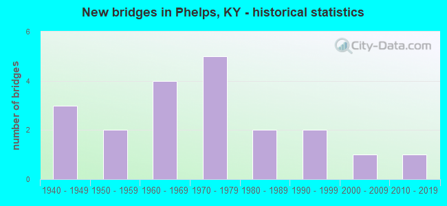
- New bridges - historical statistics
- 31940-1949
- 21950-1959
- 41960-1969
- 51970-1979
- 21980-1989
- 21990-1999
- 12000-2009
- 12010-2019


- Bridge Condition - Deck
- 18.2%Good
- 36.4%Satisfactory
- 45.5%Fair

- Bridge Condition - Superstructure
- 18.2%Good
- 36.4%Satisfactory
- 18.2%Fair
- 18.2%Poor
- 9.1%Critical

- Bridge Condition - Substructure
- 18.2%Good
- 36.4%Satisfactory
- 36.4%Fair
- 9.1%Poor

- Bridge Condition - Channel
- 12.5%Very good
- 62.5%Good
- 6.3%Satisfactory
- 18.8%Fair

- Bridge Condition - Culverts
- 40.0%Good
- 20.0%Satisfactory
- 40.0%Fair
Find on map >> Show street view
Structure Number: 98B00039N, Location: 2.3 MI SW OF JCT KY 2062 (Lat: 37.465000, Lng: -82.129722), Route carried "on" structure: State highway 194, Year Built: 1941, Status: Posted for load, Structure Length: 3.02m (9.91ft), Average Daily Traffic: 623 (year 2019), Truck Traffic: 5%, Average Future Daily Traffic: 548 (year 2039), Design Load: H 15, Features Intersected: PETER CREEK
Minimum Vertical Clearance: 30+ m (98+ ft), Kilometerpoint: 81.990, Lanes on structure: 2, Owner: State Highway Agency, Approaching Roadway Width: 6.4m (21.0ft), Skew: 4 degrees, Material/Design: Concrete, Design/Construction: Tee Beam, Number Of Spans In Main Unit: 3, Length of Maximum Span: 9.1m (29.9ft), Curb or Sidewalk Widths: Left: 0.3m (1.0ft), Right: 0.3m (1.0ft), Curb-To-Curb Width: 6.7m (22.0ft), Out-to-Out Width: 7.9m (25.9ft)
Condition: Deck: Satisfactory, Superstructure: Satisfactory, Substructure: Fair, Channel: Fair, Operating Rating: 57.3 metric tons, Method Used To Determine Operating Rating: Load Factor (LF), Inventory Rating: 34.4 metric tons, Method Used To Determine Inventory Rating: Load Factor (LF), Structural Evaluation: Somewhat better than minimum adequacy, Deck Geometry: Meets minimum limits, Waterway Adequacy: Equal to present desirable criteria, Approach Roadway Alignment: Equal to present minimum criteria, Bridge Posting: Required (Relationship of Operating Rating to Maximum Legal Load: 20.0 - 29.9% below), Length Of Structure Improvement: 0.30m (0.98ft), Designated Inspection Frequency: Every 24 months, Inspection Date: January 2020, Bridge Improvement Cost: $297,000, Total Project Cost: $297,000, Deck Structure Type: Concrete Cast-file-Place, Wearing Surface/Protective System: Wearing Surface: Bituminous
Find on map >> Show street view
Structure Number: 98B00136N, Location: W @E-JCT KY 194 @PHELPS (Lat: 37.514444, Lng: -82.152500), Route carried "on" structure: State highway 632, Year Built: 1959, Status: Posted for load, Structure Length: 2.32m (7.61ft), Average Daily Traffic: 3,579 (year 2019), Truck Traffic: 11%, Average Future Daily Traffic: 2,970 (year 2039), Design Load: H 20, Features Intersected: PETER CREEK
Minimum Vertical Clearance: 30+ m (98+ ft), Kilometerpoint: 22.536, Lanes on structure: 2, Base Highway Network: Yes, Owner: State Highway Agency, Approaching Roadway Width: 8.8m (28.9ft), Skew: 3 degrees, Material/Design: Concrete, Design/Construction: Tee Beam, Number Of Spans In Main Unit: 2, Length of Maximum Span: 10.7m (35.1ft), Curb or Sidewalk Widths: Left: 0.6m (2.0ft), Right: 0.6m (2.0ft), Curb-To-Curb Width: 7.9m (25.9ft), Out-to-Out Width: 9.8m (32.2ft)
Condition: Deck: Satisfactory, Superstructure: Satisfactory, Substructure: Fair, Channel: Good, Operating Rating: 81.2 metric tons, Method Used To Determine Operating Rating: Load Factor (LF), Inventory Rating: 48.7 metric tons, Method Used To Determine Inventory Rating: Load Factor (LF), Structural Evaluation: Somewhat better than minimum adequacy, Deck Geometry: High priority of corrective action, Waterway Adequacy: Equal to present desirable criteria, Approach Roadway Alignment: Equal to present desirable criteria, Length Of Structure Improvement: 0.23m (0.75ft), Designated Inspection Frequency: Every 24 months, Inspection Date: January 2021, Bridge Improvement Cost: $287,000, Total Project Cost: $286,000, Deck Structure Type: Concrete Cast-file-Place, Wearing Surface/Protective System: Wearing Surface: Monolithic Concrete
Find on map >> Show street view
Structure Number: 98B00178N, Location: 2.409 MI S OF JCT KY1056 (Lat: 37.525278, Lng: -82.207222), Route carried "on" structure: State highway 3419, Year Built: 1950, Status: Open, Structure Length: 0.94m (3.08ft), Average Daily Traffic: 575 (year 2020), Average Future Daily Traffic: 500 (year 2040), Features Intersected: LT FK BLACKBERRY
Minimum Vertical Clearance: 30+ m (98+ ft), Kilometerpoint: 15.210, Lanes on structure: 2, Owner: State Highway Agency, Approaching Roadway Width: 4.6m (15.1ft), Skew: 4 degrees, Material/Design: Concrete, Design/Construction: Culvert, Number Of Spans In Main Unit: 2, Length of Maximum Span: 4.3m (14.1ft)
Condition: Channel: Fair, Culverts: Fair, Operating Rating: 54.4 metric tons, Method Used To Determine Operating Rating: Field evaluation and documented engineering judgment, Inventory Rating: 39.9 metric tons, Method Used To Determine Inventory Rating: Field evaluation and documented engineering judgment, Structural Evaluation: Somewhat better than minimum adequacy, Waterway Adequacy: Equal to present minimum criteria, Approach Roadway Alignment: Equal to present minimum criteria, Designated Inspection Frequency: Every 12 months, Inspection Date: January 2021
Find on map >> Show street view
Structure Number: 98B00180N, Location: 0.5 MI S of JCT KY 1056 (Lat: 37.545556, Lng: -82.199444), Route carried "on" structure: State highway 3419, Year Built: 1975, Status: Posted for load, Structure Length: 1.19m (3.90ft), Average Daily Traffic: 575 (year 2020), Average Future Daily Traffic: 500 (year 2040), Features Intersected: Left Frk Blackberry Crk
Minimum Vertical Clearance: 30+ m (98+ ft), Kilometerpoint: 18.226, Lanes on structure: 1, Owner: State Highway Agency, Approaching Roadway Width: 6.1m (20.0ft), Skew: 4 degrees, Material/Design: Steel, Design/Construction: Stringer/Multi-beam, Number Of Spans In Main Unit: 1, Length of Maximum Span: 11.3m (37.1ft), Curb-To-Curb Width: 3.7m (12.1ft), Out-to-Out Width: 3.7m (12.1ft)
Condition: Deck: Fair, Superstructure: Poor, Substructure: Fair, Channel: Fair, Operating Rating: 39.4 metric tons, Method Used To Determine Operating Rating: Load Factor (LF), Inventory Rating: 23.6 metric tons, Method Used To Determine Inventory Rating: Load Factor (LF), Structural Evaluation: Meets minimum limits, Deck Geometry: High priority of replacement, Waterway Adequacy: Better than present minimum criteria, Approach Roadway Alignment: High priority of corrective action, Bridge Posting: Required (Relationship of Operating Rating to Maximum Legal Load: > 39.9% below), Length Of Structure Improvement: 0.12m (0.39ft), Designated Inspection Frequency: Every 12 months, Inspection Date: January 2021, Bridge Improvement Cost: $58,000, Total Project Cost: $58,000, Deck Structure Type: Concrete Cast-file-Place, Wearing Surface/Protective System: Wearing Surface: Bituminous
Find on map >> Show street view
Structure Number: 98B00195N, Location: @ JCT KY 1056 (Lat: 37.552500, Lng: -82.200278), Route carried "on" structure: State highway 3419, Year Built: 1988, Status: Open, Structure Length: 1.07m (3.51ft), Average Daily Traffic: 575 (year 2020), Average Future Daily Traffic: 500 (year 2040), Design Load: HS 20, Features Intersected: LEFT FK-BLACKBERRY CK
Minimum Vertical Clearance: 30+ m (98+ ft), Kilometerpoint: 19.064, Lanes on structure: 2, Owner: State Highway Agency, Approaching Roadway Width: 7.6m (24.9ft), Material/Design: Prestressed concrete, Design/Construction: Box Beam or Girders - Multiple, Number Of Spans In Main Unit: 1, Length of Maximum Span: 10.1m (33.1ft), Curb-To-Curb Width: 7.8m (25.6ft), Out-to-Out Width: 8.2m (26.9ft)
Condition: Deck: Fair, Superstructure: Poor, Substructure: Satisfactory, Channel: Good, Operating Rating: 62.5 metric tons, Method Used To Determine Operating Rating: Load Factor (LF), Inventory Rating: 37.5 metric tons, Method Used To Determine Inventory Rating: Load Factor (LF), Structural Evaluation: Meets minimum limits, Deck Geometry: Meets minimum limits, Waterway Adequacy: Better than present minimum criteria, Approach Roadway Alignment: Equal to present minimum criteria, Designated Inspection Frequency: Every 24 months, Inspection Date: January 2021, Deck Structure Type: Concrete Precast Panels, Wearing Surface/Protective System: Wearing Surface: Bituminous
Find on map >> Show street view
Structure Number: 98B00221N, Location: 1.86 MI S - KY 1056 (Lat: 37.528611, Lng: -82.198333), Route carried "on" structure: State highway 3419, Year Built: 1993, Status: Open, Structure Length: 0.98m (3.22ft), Average Daily Traffic: 575 (year 2020), Average Future Daily Traffic: 500 (year 2040), Features Intersected: LT FK BLACKBERRY CK
Minimum Vertical Clearance: 30+ m (98+ ft), Kilometerpoint: 16.089, Lanes on structure: 2, Owner: State Highway Agency, Approaching Roadway Width: 6.1m (20.0ft), Skew: 4 degrees, Material/Design: Concrete, Design/Construction: Culvert, Number Of Spans In Main Unit: 2, Length of Maximum Span: 2.7m (8.9ft), Curb-To-Curb Width: 8.3m (27.2ft), Out-to-Out Width: 8.9m (29.2ft)
Condition: Channel: Good, Culverts: Good, Operating Rating: 54.4 metric tons, Method Used To Determine Operating Rating: Field evaluation and documented engineering judgment, Inventory Rating: 39.9 metric tons, Method Used To Determine Inventory Rating: Field evaluation and documented engineering judgment, Structural Evaluation: Better than present minimum criteria, Deck Geometry: Somewhat better than minimum adequacy, Waterway Adequacy: Equal to present desirable criteria, Approach Roadway Alignment: High priority of corrective action, Designated Inspection Frequency: Every 24 months, Inspection Date: January 2021
Find on map >> Show street view
Structure Number: 98B00236N, Location: .1 MI. N JCT KY 632 (Lat: 37.494167, Lng: -82.187222), Route carried "on" structure: State highway 3419, Year Built: 1998, Status: Open, Structure Length: 0.79m (2.59ft), Average Daily Traffic: 236 (year 2020), Average Future Daily Traffic: 205 (year 2040), Design Load: HS 25 or greater, Features Intersected: CALLOWAY CREEK
Minimum Vertical Clearance: 30+ m (98+ ft), Kilometerpoint: 8.884, Lanes on structure: 2, Owner: State Highway Agency, Approaching Roadway Width: 6.7m (22.0ft), Skew: 3 degrees, Material/Design: Prestressed concrete, Design/Construction: Box Beam or Girders - Multiple, Number Of Spans In Main Unit: 1, Length of Maximum Span: 7.3m (24.0ft), Curb-To-Curb Width: 7.2m (23.6ft), Out-to-Out Width: 7.6m (24.9ft)
Condition: Deck: Good, Superstructure: Good, Substructure: Good, Channel: Good, Operating Rating: 68.3 metric tons, Method Used To Determine Operating Rating: Load Factor (LF), Inventory Rating: 41.0 metric tons, Method Used To Determine Inventory Rating: Load Factor (LF), Structural Evaluation: Better than present minimum criteria, Deck Geometry: Meets minimum limits, Waterway Adequacy: Equal to present minimum criteria, Approach Roadway Alignment: Equal to present minimum criteria, Designated Inspection Frequency: Every 24 months, Inspection Date: January 2020, Deck Structure Type: Concrete Cast-file-Place, Wearing Surface/Protective System: Wearing Surface: Bituminous, Deck Protection: Epoxy Coated Reinforcing
Find on map >> Show street view
Structure Number: 98B00248N, Location: .25 MI SE JCT KY 632 (Lat: 37.485278, Lng: -82.184167), Route carried "on" structure: State highway 3419, Year Built: 2002, Status: Open, Structure Length: 1.89m (6.20ft), Average Daily Traffic: 805 (year 2018), Average Future Daily Traffic: 700 (year 2038), Design Load: HS 25 or greater, Features Intersected: SMITH FORK
Minimum Vertical Clearance: 30+ m (98+ ft), Kilometerpoint: 7.548, Lanes on structure: 2, Owner: State Highway Agency, Approaching Roadway Width: 11.6m (38.1ft), Skew: 4 degrees, Material/Design: Prestressed concrete, Design/Construction: Box Beam or Girders - Single/Spread, Number Of Spans In Main Unit: 1, Length of Maximum Span: 17.7m (58.1ft), Curb-To-Curb Width: 9.1m (29.9ft), Out-to-Out Width: 10.1m (33.1ft)
Condition: Deck: Good, Superstructure: Good, Substructure: Good, Channel: Very good, Operating Rating: 99.8 metric tons, Method Used To Determine Operating Rating: Load Factor (LF), Inventory Rating: 60.2 metric tons, Method Used To Determine Inventory Rating: Load Factor (LF), Structural Evaluation: Better than present minimum criteria, Deck Geometry: Equal to present minimum criteria, Waterway Adequacy: Equal to present desirable criteria, Approach Roadway Alignment: Equal to present desirable criteria, Designated Inspection Frequency: Every 24 months, Inspection Date: January 2021, Deck Structure Type: Concrete Cast-file-Place, Wearing Surface/Protective System: Wearing Surface: Monolithic Concrete, Deck Protection: Epoxy Coated Reinforcing
Find on map >> Show street view
Structure Number: 98B00271N, Location: .1 MI SE OF JCT KY 632 (Lat: 37.487222, Lng: -82.186944), Route carried "on" structure: State highway 3419, Year Built: 2011, Status: Open, Structure Length: 0.66m (2.17ft), Average Daily Traffic: 805 (year 2018), Average Future Daily Traffic: 700 (year 2038), Design Load: Greater than HL93, Features Intersected: RIGHT FRK OF PETER CREEK
Minimum Vertical Clearance: 30+ m (98+ ft), Kilometerpoint: 7.878, Lanes on structure: 2, Owner: State Highway Agency, Approaching Roadway Width: 11.3m (37.1ft), Skew: 11 degrees, Material/Design: Concrete, Design/Construction: Culvert, Number Of Spans In Main Unit: 1, Length of Maximum Span: 6.6m (21.7ft), Curb-To-Curb Width: 11.4m (37.4ft), Out-to-Out Width: 11.9m (39.0ft)
Condition: Channel: Very good, Culverts: Good, Operating Rating: 46.7 metric tons, Method Used To Determine Operating Rating: Load and Resistance Factor Rating (LRFR) rating reported by rating factor(RF) method using HL-93 loadings, Inventory Rating: 36.0 metric tons, Method Used To Determine Inventory Rating: Load and Resistance Factor Rating (LRFR) rating reported by rating factor(RF) method using HL-93 loadings, Structural Evaluation: Better than present minimum criteria, Deck Geometry: Better than present minimum criteria, Waterway Adequacy: Equal to present desirable criteria, Approach Roadway Alignment: Equal to present desirable criteria, Designated Inspection Frequency: Every 24 months, Inspection Date: January 2021
Find on map >> Show street view
Structure Number: 98C00033N, Location: .1 MI W OF JCT KY 194 (Lat: 37.496111, Lng: -82.136944), Route carried "on" structure: County highway 1867, Year Built: 1976, Status: Open, Structure Length: 1.10m (3.61ft), Average Daily Traffic: 1,729 (year 2012), Average Future Daily Traffic: 1,504 (year 2032), Design Load: HS 20, Features Intersected: LT FORK OF PETER CR, Facility Carried by Structure: PHILLIPS BRANCH RD
Minimum Vertical Clearance: 30+ m (98+ ft), Kilometerpoint: 0.011, Lanes on structure: 2, Owner: County Highway Agency, Approaching Roadway Width: 6.1m (20.0ft), Material/Design: Prestressed concrete, Design/Construction: Box Beam or Girders - Multiple, Number Of Spans In Main Unit: 1, Length of Maximum Span: 10.1m (33.1ft), Curb-To-Curb Width: 6.8m (22.3ft), Out-to-Out Width: 7.4m (24.3ft)
Condition: Deck: Fair, Superstructure: Fair, Substructure: Satisfactory, Channel: Good, Operating Rating: 89.7 metric tons, Method Used To Determine Operating Rating: Load Factor (LF), Inventory Rating: 53.9 metric tons, Method Used To Determine Inventory Rating: Load Factor (LF), Structural Evaluation: Somewhat better than minimum adequacy, Deck Geometry: High priority of corrective action, Waterway Adequacy: Equal to present desirable criteria, Approach Roadway Alignment: High priority of corrective action, Designated Inspection Frequency: Every 24 months, Inspection Date: March 2020, Deck Structure Type: Concrete Precast Panels
Find on map >> Show street view
Structure Number: 98C00035N, Location: .1 MI SE OF JCT KY 632 (Lat: 37.505000, Lng: -82.159722), Route carried "on" structure: County highway 1843, Year Built: 1970, Status: Closed, Structure Length: 1.37m (4.49ft), Average Daily Traffic: 368 (year 2011), Average Future Daily Traffic: 320 (year 2031), Features Intersected: RT FORK OF PETER CR., Facility Carried by Structure: ELM BR
Minimum Vertical Clearance: 30+ m (98+ ft), Kilometerpoint: 0.021, Lanes on structure: 1, Owner: County Highway Agency, Approaching Roadway Width: 4.0m (13.1ft), Material/Design: Steel, Design/Construction: Stringer/Multi-beam, Number Of Spans In Main Unit: 1, Length of Maximum Span: 12.2m (40.0ft), Curb or Sidewalk Widths: Left: 0.2m (0.7ft), Right: 0.2m (0.7ft), Curb-To-Curb Width: 3.8m (12.5ft), Out-to-Out Width: 4.3m (14.1ft)
Condition: Deck: Fair, Superstructure: Critical, Substructure: Poor, Channel: Good, Operating Rating: 0.2 metric tons, Method Used To Determine Operating Rating: Load Factor (LF), Inventory Rating: 0.1 metric tons, Method Used To Determine Inventory Rating: Load Factor (LF), Waterway Adequacy: Equal to present desirable criteria, Approach Roadway Alignment: Equal to present minimum criteria, Bridge Posting: Required (Relationship of Operating Rating to Maximum Legal Load: > 39.9% below), Length Of Structure Improvement: 0.14m (0.46ft), Designated Inspection Frequency: Every 12 months, Inspection Date: March 2021, Bridge Improvement Cost: $94,000, Total Project Cost: $94,000, Deck Structure Type: Concrete Cast-file-Place, Wearing Surface/Protective System: Wearing Surface: Bituminous
Find on map >> Show street view
Structure Number: 98C00084N, Location: SE @JCT KY 632 (Lat: 37.503056, Lng: -82.162222), Route carried "on" structure: County highway 1842, Year Built: 1975, Status: Open, Structure Length: 1.07m (3.51ft), Average Daily Traffic: 12 (year 2011), Average Future Daily Traffic: 10 (year 2031), Design Load: H 20, Features Intersected: PETER CREEK, Facility Carried by Structure: MAPLE ST
Minimum Vertical Clearance: 30+ m (98+ ft), Kilometerpoint: 0.014, Lanes on structure: 2, Owner: County Highway Agency, Approaching Roadway Width: 3.7m (12.1ft), Skew: 3 degrees, Material/Design: Prestressed concrete, Design/Construction: Box Beam or Girders - Multiple, Number Of Spans In Main Unit: 1, Length of Maximum Span: 9.8m (32.2ft), Curb-To-Curb Width: 5.2m (17.1ft), Out-to-Out Width: 5.7m (18.7ft)
Condition: Deck: Satisfactory, Superstructure: Satisfactory, Substructure: Satisfactory, Channel: Good, Operating Rating: 82.7 metric tons, Method Used To Determine Operating Rating: Load Factor (LF), Inventory Rating: 49.6 metric tons, Method Used To Determine Inventory Rating: Load Factor (LF), Structural Evaluation: Equal to present minimum criteria, Deck Geometry: High priority of corrective action, Waterway Adequacy: Equal to present desirable criteria, Approach Roadway Alignment: High priority of corrective action, Length Of Structure Improvement: 0.11m (0.36ft), Designated Inspection Frequency: Every 24 months, Inspection Date: March 2020, Bridge Improvement Cost: $81,000, Total Project Cost: $81,000, Deck Structure Type: Concrete Precast Panels
Find on map >> Show street view
Structure Number: 98C00089N, Location: 100' SW OF JCT KY 194 (Lat: 37.484444, Lng: -82.134167), Route carried "on" structure: County highway 1106, Year Built: 1978, Status: Posted for load, Structure Length: 1.40m (4.59ft), Average Daily Traffic: 150 (year 2006), Average Future Daily Traffic: 2,026 (year 2026), Design Load: HS 20, Features Intersected: PETER CREEK, Facility Carried by Structure: BEECH CRK
Minimum Vertical Clearance: 30+ m (98+ ft), Kilometerpoint: 0.013, Lanes on structure: 2, Owner: County Highway Agency, Approaching Roadway Width: 4.6m (15.1ft), Skew: 1 degrees, Material/Design: Prestressed concrete, Design/Construction: Box Beam or Girders - Multiple, Number Of Spans In Main Unit: 1, Length of Maximum Span: 11.9m (39.0ft), Curb-To-Curb Width: 7.0m (23.0ft), Out-to-Out Width: 7.3m (24.0ft)
Condition: Deck: Fair, Superstructure: Fair, Substructure: Fair, Channel: Good, Operating Rating: 41.2 metric tons, Method Used To Determine Operating Rating: Load Factor (LF), Inventory Rating: 24.8 metric tons, Method Used To Determine Inventory Rating: Load Factor (LF), Structural Evaluation: Somewhat better than minimum adequacy, Deck Geometry: Meets minimum limits, Waterway Adequacy: Equal to present desirable criteria, Approach Roadway Alignment: Equal to present desirable criteria, Bridge Posting: Required (Relationship of Operating Rating to Maximum Legal Load: 10.0 - 19.9% below), Designated Inspection Frequency: Every 24 months, Inspection Date: March 2020, Deck Structure Type: Concrete Precast Panels
Find on map >> Show street view
Structure Number: 98C00099N, Location: .1 MI W OF JCT KY 1056 (Lat: 37.548333, Lng: -82.210833), Route carried "on" structure: County highway 1804, Year Built: 1947, Status: Posted for load, Structure Length: 0.82m (2.69ft), Average Daily Traffic: 629 (year 2012), Average Future Daily Traffic: 547 (year 2032), Design Load: H 15, Features Intersected: RT.FK.BLACKBERRY CREEK, Facility Carried by Structure: UPPER BLACKBERRY R
Minimum Vertical Clearance: 30+ m (98+ ft), Kilometerpoint: 0.161, Lanes on structure: 1, Owner: County Highway Agency, Approaching Roadway Width: 4.9m (16.1ft), Skew: 6 degrees, Material/Design: Concrete, Design/Construction: Culvert, Number Of Spans In Main Unit: 2, Length of Maximum Span: 3.7m (12.1ft)
Condition: Channel: Satisfactory, Culverts: Satisfactory, Operating Rating: 16.4 metric tons, Method Used To Determine Operating Rating: Field evaluation and documented engineering judgment, Inventory Rating: 16.3 metric tons, Method Used To Determine Inventory Rating: Field evaluation and documented engineering judgment, Structural Evaluation: Meets minimum limits, Waterway Adequacy: Better than present minimum criteria, Approach Roadway Alignment: Equal to present minimum criteria, Bridge Posting: Required (Relationship of Operating Rating to Maximum Legal Load: > 39.9% below), Designated Inspection Frequency: Every 24 months, Inspection Date: March 2021
Find on map >> Show street view
Structure Number: 98C00101N, Location: .9 MI W OF JCT KY 1056 (Lat: 37.540833, Lng: -82.220556), Route carried "on" structure: County highway 1804, Year Built: 1947, Status: Posted for load, Structure Length: 0.70m (2.30ft), Average Daily Traffic: 254 (year 2012), Average Future Daily Traffic: 220 (year 2032), Design Load: H 15, Features Intersected: RT FK BLACKBERRY CREEK, Facility Carried by Structure: UPPER BLACKBERRY R
Minimum Vertical Clearance: 30+ m (98+ ft), Kilometerpoint: 1.463, Lanes on structure: 1, Owner: County Highway Agency, Approaching Roadway Width: 4.9m (16.1ft), Skew: 6 degrees, Material/Design: Concrete, Design/Construction: Culvert, Number Of Spans In Main Unit: 2, Length of Maximum Span: 3.0m (9.8ft)
Condition: Channel: Good, Culverts: Fair, Operating Rating: 16.4 metric tons, Method Used To Determine Operating Rating: Field evaluation and documented engineering judgment, Inventory Rating: 16.3 metric tons, Method Used To Determine Inventory Rating: Field evaluation and documented engineering judgment, Structural Evaluation: Somewhat better than minimum adequacy, Waterway Adequacy: Better than present minimum criteria, Approach Roadway Alignment: Equal to present minimum criteria, Bridge Posting: Required (Relationship of Operating Rating to Maximum Legal Load: > 39.9% below), Designated Inspection Frequency: Every 24 months, Inspection Date: March 2021
Find on map >> Show street view
Structure Number: 98C00107N, Location: 0.01 MI SW of JCT KY 194 (Lat: 37.541111, Lng: -82.162222), Route carried "on" structure: County highway 1828, Year Built: 1986, Status: Open, Structure Length: 2.23m (7.32ft), Average Daily Traffic: 198 (year 2011), Average Future Daily Traffic: 172 (year 2031), Design Load: HS 20, Features Intersected: Peter Creek, Facility Carried by Structure: Billy Dotson Br
Minimum Vertical Clearance: 30+ m (98+ ft), Kilometerpoint: 0.021, Lanes on structure: 2, Owner: County Highway Agency, Approaching Roadway Width: 5.2m (17.1ft), Material/Design: Prestressed concrete, Design/Construction: Box Beam or Girders - Multiple, Number Of Spans In Main Unit: 1, Length of Maximum Span: 21.3m (69.9ft), Curb-To-Curb Width: 6.1m (20.0ft), Out-to-Out Width: 6.6m (21.7ft)
Condition: Deck: Satisfactory, Superstructure: Satisfactory, Substructure: Satisfactory, Channel: Good, Operating Rating: 44.1 metric tons, Method Used To Determine Operating Rating: Load Factor (LF), Inventory Rating: 26.5 metric tons, Method Used To Determine Inventory Rating: Load Factor (LF), Structural Evaluation: Equal to present minimum criteria, Deck Geometry: Meets minimum limits, Waterway Adequacy: Equal to present desirable criteria, Approach Roadway Alignment: High priority of corrective action, Designated Inspection Frequency: Every 24 months, Inspection Date: March 2020, Deck Structure Type: Concrete Precast Panels
Find on map >> Show street view
Structure Number: 98R00606N, Location: .9 MI S OF JCT KY 2062 (Lat: 37.491667, Lng: -82.134722), Route carried "under" structure: State highway 194, Year Built: 1966, Structure Length: 0. m, Average Daily Traffic: 1,564 (year 2020), Truck Traffic: 17%, Features Intersected: KY-194, Facility Carried by Structure: N&S Railroad
Minimum Vertical Clearance: 5.61m (18.41ft), Kilometerpoint: 85.023, Lanes under structure: 2, Material/Design: Steel, Design/Construction: Girder and Floorbeam System, Length of Maximum Span: 21.0m (68.9ft)
Find on map >> Show street view
Structure Number: 98R00607N, Location: .2 MI W OF JCT KY 194 (Lat: 37.513611, Lng: -82.154167), Route carried "under" structure: State highway 632, Year Built: 1966, Structure Length: 0. m, Average Daily Traffic: 2,691 (year 2018), Truck Traffic: 11%, Features Intersected: KY-632/R Frk Peter Crk, Facility Carried by Structure: N&S Railroad
Minimum Vertical Clearance: 6.20m (20.34ft), Kilometerpoint: 22.376, Lanes under structure: 2, Material/Design: Steel, Design/Construction: Girder and Floorbeam System, Length of Maximum Span: 16.2m (53.1ft)
Find on map >> Show street view
Structure Number: 98R00608N, Location: 0.35 MI-JCT KY 194 (Lat: 37.513056, Lng: -82.157778), Route carried "under" structure: State highway 632, Year Built: 1965, Structure Length: 0. m, Average Daily Traffic: 2,691 (year 2018), Truck Traffic: 11%, Features Intersected: KY-632/R Frk Peter Crk, Facility Carried by Structure: N&S Railroad
Minimum Vertical Clearance: 4.37m (14.34ft), Kilometerpoint: 22.027, Lanes under structure: 2, Material/Design: Steel, Design/Construction: Stringer/Multi-beam, Length of Maximum Span: 18.3m (60.0ft)
Find on map >> Show street view
Structure Number: 98R00609N, Location: 2.75 MI W of JCT KY 194 (Lat: 37.499722, Lng: -82.184167), Route carried "under" structure: State highway 632, Year Built: 1965, Structure Length: 0. m, Average Daily Traffic: 1,338 (year 2020), Truck Traffic: 11%, Features Intersected: KY-632/R Frk Peter Crk, Facility Carried by Structure: N&S Railroad
Minimum Vertical Clearance: 4.32m (14.17ft), Kilometerpoint: 18.303, Lanes under structure: 2, Material/Design: Steel, Design/Construction: Girder and Floorbeam System, Length of Maximum Span: 22.9m (75.1ft)