Bridge Statistics for Picnic Point-North Lynnwood, Washington (WA)
Condition, Traffic, Stress, Structural Evaluation, Project Costs
- National Bridge Inventory (NBI) Statistics
- 18Number of bridges
- 469ft / 143mTotal length
- $99,138,000Total costs
- 877,129Total average daily traffic
- 53,051Total average daily truck traffic
- National Bridge Inventory (NBI) Registered Bridges for Picnic Point-North Lynnwood
- No street view available for this location
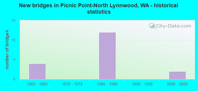
- New bridges - historical statistics
- 41960-1969
- 121980-1989
- 22000-2009
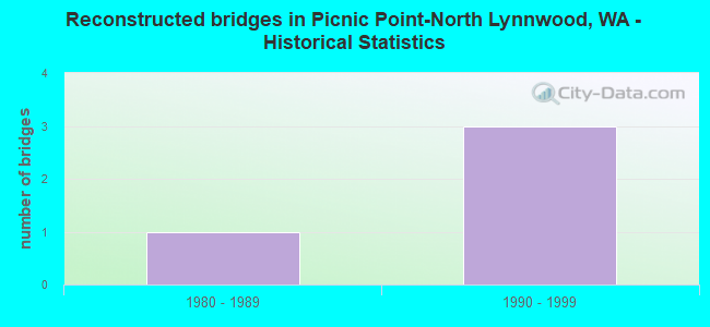
- Reconstructed bridges - Historical Statistics
- 11980-1989
- 31990-1999
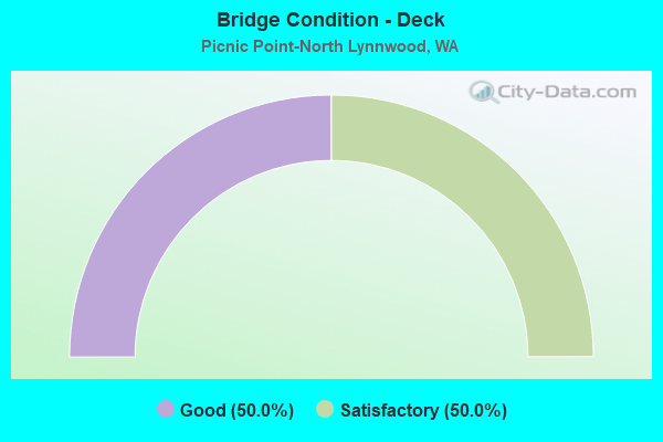
- Bridge Condition - Deck
- 50.0%Good
- 50.0%Satisfactory
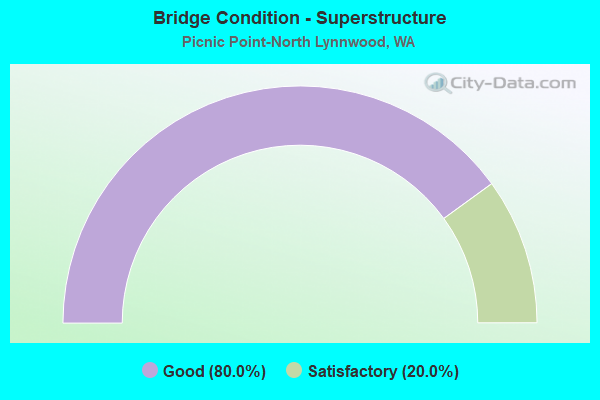
- Bridge Condition - Superstructure
- 80.0%Good
- 20.0%Satisfactory
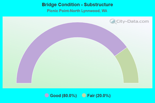
- Bridge Condition - Substructure
- 80.0%Good
- 20.0%Fair
Find on map >> Show street view
Structure Number: 11561A, Location: 1.3 N JCT I-405 (Lat: 47.849833, Lng: -122.258139), Route carried "on" structure: County highway , Year Built: 1963, Year Reconstructed: 2001, Status: Open, Structure Length: 9.85m (32.32ft), Average Daily Traffic: 44,483 (year 2010), Truck Traffic: 5%, Average Future Daily Traffic: 75,710 (year 2036), Design Load: HS 20+Mod, Features Intersected: I-5, Facility Carried by Structure: 164TH ST SW
Minimum Vertical Clearance: 30+ m (98+ ft), Kilometerpoint: 0.177, Lanes on structure: 6, Lanes under structure: 14, Base Highway Network: Yes, Owner: State Highway Agency, Approaching Roadway Width: 24.7m (81.0ft), Material/Design: Prestressed concrete, Design/Construction: Stringer/Multi-beam, Number Of Spans In Main Unit: 4, Length of Maximum Span: 30.5m (100.1ft), Curb or Sidewalk Widths: Left: 2.0m (6.6ft), Right: 2.0m (6.6ft), Curb-To-Curb Width: 24.6m (80.7ft), Out-to-Out Width: 29.2m (95.8ft)
Condition: Deck: Good, Superstructure: Good, Substructure: Good, Operating Rating: 59.0 metric tons, Method Used To Determine Operating Rating: Load Factor (LF), Inventory Rating: 34.5 metric tons, Method Used To Determine Inventory Rating: Load Factor (LF), Structural Evaluation: Better than present minimum criteria, Deck Geometry: Somewhat better than minimum adequacy, Underclear: Meets minimum limits, Approach Roadway Alignment: Equal to present desirable criteria, Length Of Structure Improvement: 9.85m (32.32ft), Designated Inspection Frequency: Every 48 months, Inspection Date: April 2018, Bridge Improvement Cost: $5,362,000, Roadway Improvement Cost: $1,072,000, Total Project Cost: $10,724,000 ( Estimate for 2014), Deck Structure Type: Concrete Cast-file-Place, Wearing Surface/Protective System: Wearing Surface: Latex Concrete
Find on map >> Show street view
Structure Number: 11598C, Location: 1.1 N JCT SR 524 (Lat: 47.832028, Lng: -122.262778), Route carried "on" structure: Interstate 5, Year Built: 1980, Year Reconstructed: 1995, Status: Open, Structure Length: 8.38m (27.49ft), Average Daily Traffic: 71,003 (year 2019), Truck Traffic: 6%, Average Future Daily Traffic: 102,812 (year 2039), Design Load: HS 20+Mod, Features Intersected: S 405 & N 525 RAMPS
Minimum Vertical Clearance: 30+ m (98+ ft), Kilometerpoint: 293.898, Lanes on structure: 4, Lanes under structure: 4, Base Highway Network: Yes, Owner: State Highway Agency, Approaching Roadway Width: 23.5m (77.1ft), Skew: 5 degrees, Material/Design: Prestressed concrete continuous, Design/Construction: Stringer/Multi-beam, Number Of Spans In Main Unit: 2, Length of Maximum Span: 42.7m (140.1ft), Curb-To-Curb Width: 20.7m (67.9ft), Out-to-Out Width: 21.6m (70.9ft)
Condition: Deck: Satisfactory, Superstructure: Good, Substructure: Good, Operating Rating: 64.4 metric tons, Method Used To Determine Operating Rating: Load Factor (LF), Inventory Rating: 38.1 metric tons, Method Used To Determine Inventory Rating: Load Factor (LF), Structural Evaluation: Better than present minimum criteria, Deck Geometry: Equal to present minimum criteria, Underclear: Equal to present minimum criteria, Approach Roadway Alignment: Equal to present desirable criteria, Length Of Structure Improvement: 8.38m (27.49ft), Designated Inspection Frequency: Every 24 months, Inspection Date: Febuary 2020, Bridge Improvement Cost: $4,345,000, Roadway Improvement Cost: $869,000, Total Project Cost: $8,690,000 ( Estimate for 2014), Deck Structure Type: Concrete Cast-file-Place, Wearing Surface/Protective System: Wearing Surface: Monolithic Concrete, Deck Protection: Epoxy Coated Reinforcing
Find on map >> Show street view
Structure Number: 11598D, Location: 0.3 N JCT I-405 (Lat: 47.834639, Lng: -122.262306), Route carried "on" structure: City street , Year Built: 1962, Year Reconstructed: 1980, Status: Open, Structure Length: 14.57m (47.80ft), Average Daily Traffic: 8,340 (year 2002), Truck Traffic: 1%, Average Future Daily Traffic: 15,145 (year 2036), Design Load: HS 20, Features Intersected: I-5, Facility Carried by Structure: MAPLE ROAD
Minimum Vertical Clearance: 30+ m (98+ ft), Kilometerpoint: 0.692, Lanes on structure: 2, Lanes under structure: 11, Owner: State Highway Agency, Approaching Roadway Width: 9.4m (30.8ft), Skew: 3 degrees, Material/Design: Prestressed concrete, Design/Construction: Stringer/Multi-beam, Number Of Spans In Main Unit: 6, Length of Maximum Span: 32.6m (107.0ft), Curb or Sidewalk Widths: Left: 0.9m (3.0ft), Right: 0.9m (3.0ft), Curb-To-Curb Width: 7.9m (25.9ft), Out-to-Out Width: 10.3m (33.8ft)
Condition: Deck: Satisfactory, Superstructure: Good, Substructure: Good, Operating Rating: 76.2 metric tons, Method Used To Determine Operating Rating: Load Factor (LF), Inventory Rating: 44.4 metric tons, Method Used To Determine Inventory Rating: Load Factor (LF), Structural Evaluation: Better than present minimum criteria, Deck Geometry: High priority of corrective action, Underclear: High priority of corrective action, Approach Roadway Alignment: Equal to present desirable criteria, Length Of Structure Improvement: 14.57m (47.80ft), Designated Inspection Frequency: Every 24 months, Inspection Date: October 2021, Bridge Improvement Cost: $3,155,000, Roadway Improvement Cost: $631,000, Total Project Cost: $6,310,000 ( Estimate for 2014), Deck Structure Type: Concrete Cast-file-Place, Wearing Surface/Protective System: Wearing Surface: Monolithic Concrete
Find on map >> Show street view
Structure Number: 11627A, Location: 1.4 N JCT I-5 (Lat: 47.850000, Lng: -122.274806), Route carried "on" structure: County highway , Year Built: 1980, Status: Open, Structure Length: 6.43m (21.10ft), Average Daily Traffic: 30,703 (year 2012), Truck Traffic: 15%, Average Future Daily Traffic: 38,212 (year 2033), Design Load: HS 20+Mod, Features Intersected: SR 525, Facility Carried by Structure: 164TH ST SW
Minimum Vertical Clearance: 30+ m (98+ ft), Kilometerpoint: 0.531, Lanes on structure: 4, Lanes under structure: 4, Owner: State Highway Agency, Approaching Roadway Width: 17.1m (56.1ft), Material/Design: Prestressed concrete continuous, Design/Construction: Stringer/Multi-beam, Number Of Spans In Main Unit: 2, Length of Maximum Span: 36.6m (120.1ft), Curb or Sidewalk Widths: Left: 1.2m (3.9ft), Right: 2.4m (7.9ft), Curb-To-Curb Width: 13.4m (44.0ft), Out-to-Out Width: 17.7m (58.1ft)
Condition: Deck: Satisfactory, Superstructure: Good, Substructure: Good, Operating Rating: 34.3 metric tons, Method Used To Determine Operating Rating: Load and Resistance Factor Rating (LRFR) rating reported by rating factor(RF) method using HL-93 loadings, Inventory Rating: 26.6 metric tons, Method Used To Determine Inventory Rating: Load and Resistance Factor Rating (LRFR) rating reported by rating factor(RF) method using HL-93 loadings, Structural Evaluation: Equal to present minimum criteria, Deck Geometry: High priority of replacement, Underclear: Equal to present minimum criteria, Approach Roadway Alignment: Equal to present desirable criteria, Length Of Structure Improvement: 6.43m (21.10ft), Designated Inspection Frequency: Every 24 months, Inspection Date: October 2021, Bridge Improvement Cost: $2,448,000, Roadway Improvement Cost: $490,000, Total Project Cost: $4,895,000 ( Estimate for 2014), Deck Structure Type: Concrete Cast-file-Place, Wearing Surface/Protective System: Wearing Surface: Monolithic Concrete
Find on map >> Show street view
Structure Number: 11627B, Location: 2.4 N JCT I-5 (Lat: 47.864194, Lng: -122.275250), Route carried "on" structure: County highway , Year Built: 1980, Status: Open, Structure Length: 6.71m (22.01ft), Average Daily Traffic: 8,494 (year 2020), Truck Traffic: 6%, Average Future Daily Traffic: 13,649 (year 2040), Design Load: HS 20+Mod, Features Intersected: SR 525, Facility Carried by Structure: 148TH ST SW
Minimum Vertical Clearance: 30+ m (98+ ft), Kilometerpoint: 2.076, Lanes on structure: 2, Lanes under structure: 5, Owner: State Highway Agency, Approaching Roadway Width: 12.2m (40.0ft), Material/Design: Prestressed concrete continuous, Design/Construction: Stringer/Multi-beam, Number Of Spans In Main Unit: 2, Length of Maximum Span: 39.6m (129.9ft), Curb-To-Curb Width: 12.2m (40.0ft), Out-to-Out Width: 13.1m (43.0ft)
Condition: Deck: Good, Superstructure: Good, Substructure: Good, Operating Rating: 89.8 metric tons, Method Used To Determine Operating Rating: Load Factor (LF), Inventory Rating: 58.0 metric tons, Method Used To Determine Inventory Rating: Load Factor (LF), Structural Evaluation: Better than present minimum criteria, Deck Geometry: Somewhat better than minimum adequacy, Underclear: High priority of corrective action, Approach Roadway Alignment: Equal to present desirable criteria, Length Of Structure Improvement: 6.71m (22.01ft), Designated Inspection Frequency: Every 24 months, Inspection Date: October 2021, Bridge Improvement Cost: $1,848,000, Roadway Improvement Cost: $370,000, Total Project Cost: $3,696,000 ( Estimate for 2014), Deck Structure Type: Concrete Cast-file-Place, Wearing Surface/Protective System: Wearing Surface: Monolithic Concrete
Find on map >> Show street view
Structure Number: 11855B, Location: JCT I-5 (Lat: 47.833722, Lng: -122.264639), Route carried "on" structure: Ramp Interstate 405, Year Built: 1981, Status: Open, Structure Length: 38.71m (127.00ft), Average Daily Traffic: 14,295 (year 2019), Truck Traffic: 5%, Average Future Daily Traffic: 20,699 (year 2039), Design Load: HS 20+Mod, Features Intersected: RAMPS AND SWAMP CREEK
Minimum Vertical Clearance: 30+ m (98+ ft), Kilometerpoint: 0.354, Lanes on structure: 1, Lanes under structure: 2, Owner: State Highway Agency, Approaching Roadway Width: 9.8m (32.2ft), Material/Design: Concrete continuous, Design/Construction: Box Beam or Girders - Multiple, Number Of Spans In Main Unit: 11, Length of Maximum Span: 42.7m (140.1ft), Curb-To-Curb Width: 8.5m (27.9ft), Out-to-Out Width: 9.4m (30.8ft)
Condition: Deck: Satisfactory, Superstructure: Satisfactory, Substructure: Good, Channel: Very good, Operating Rating: 67.1 metric tons, Method Used To Determine Operating Rating: Load Factor (LF), Inventory Rating: 39.9 metric tons, Method Used To Determine Inventory Rating: Load Factor (LF), Structural Evaluation: Equal to present minimum criteria, Deck Geometry: Superior to present desirable criteria, Underclear: Superior to present desirable criteria, Waterway Adequacy: Equal to present desirable criteria, Approach Roadway Alignment: Equal to present minimum criteria, Length Of Structure Improvement: 38.71m (127.00ft), Designated Inspection Frequency: Every 48 months, Inspection Date: April 2018, Bridge Improvement Cost: $8,636,000, Roadway Improvement Cost: $1,727,000, Total Project Cost: $17,272,000 ( Estimate for 2014), Deck Structure Type: Concrete Cast-file-Place, Wearing Surface/Protective System: Wearing Surface: Monolithic Concrete, Deck Protection: Epoxy Coated Reinforcing
Find on map >> Show street view
Structure Number: 11980A, Location: 0.4 N JCT I-5 (Lat: 47.836111, Lng: -122.269111), Route carried "on" structure: State highway 525, Year Built: 1983, Status: Open, Structure Length: 25.30m (83.01ft), Average Daily Traffic: 33,748 (year 2019), Truck Traffic: 4%, Average Future Daily Traffic: 48,867 (year 2039), Design Load: HS 20+Mod, Features Intersected: MAPLE RD & ASH WAY
Minimum Vertical Clearance: 30+ m (98+ ft), Kilometerpoint: 0.612, Lanes on structure: 3, Lanes under structure: 4, Base Highway Network: Yes, Owner: State Highway Agency, Approaching Roadway Width: 17.1m (56.1ft), Skew: 1 degrees, Material/Design: Prestressed concrete continuous, Design/Construction: Stringer/Multi-beam, Number Of Spans In Main Unit: 8, Length of Maximum Span: 42.4m (139.1ft), Curb-To-Curb Width: 17.1m (56.1ft), Out-to-Out Width: 20.6m (67.6ft)
Condition: Deck: Good, Superstructure: Good, Substructure: Fair, Operating Rating: 74.4 metric tons, Method Used To Determine Operating Rating: Load Factor (LF), Inventory Rating: 43.5 metric tons, Method Used To Determine Inventory Rating: Load Factor (LF), Structural Evaluation: Somewhat better than minimum adequacy, Deck Geometry: Equal to present minimum criteria, Underclear: Equal to present minimum criteria, Approach Roadway Alignment: Equal to present desirable criteria, Length Of Structure Improvement: 25.30m (83.01ft), Designated Inspection Frequency: Every 24 months, Inspection Date: October 2021, Bridge Improvement Cost: $9,628,000, Roadway Improvement Cost: $1,926,000, Total Project Cost: $19,256,000 ( Estimate for 2014), Deck Structure Type: Concrete Cast-file-Place, Wearing Surface/Protective System: Wearing Surface: Monolithic Concrete, Deck Protection: Epoxy Coated Reinforcing
Find on map >> Show street view
Structure Number: 11980B, Location: 0.4 N JCT I-5 (Lat: 47.836028, Lng: -122.269306), Route carried "on" structure: State highway 525, Year Built: 1983, Status: Open, Structure Length: 23.07m (75.69ft), Average Daily Traffic: 33,748 (year 2019), Truck Traffic: 4%, Average Future Daily Traffic: 48,867 (year 2039), Design Load: HS 20+Mod, Features Intersected: MAPLE RD & ASH WAY
Minimum Vertical Clearance: 30+ m (98+ ft), Kilometerpoint: 0.612, Lanes on structure: 3, Lanes under structure: 4, Base Highway Network: Yes, Owner: State Highway Agency, Approaching Roadway Width: 17.7m (58.1ft), Skew: 1 degrees, Material/Design: Prestressed concrete continuous, Design/Construction: Stringer/Multi-beam, Number Of Spans In Main Unit: 7, Length of Maximum Span: 42.4m (139.1ft), Curb-To-Curb Width: 17.5m (57.4ft), Out-to-Out Width: 20.9m (68.6ft)
Condition: Deck: Good, Superstructure: Good, Substructure: Fair, Operating Rating: 72.6 metric tons, Method Used To Determine Operating Rating: Load Factor (LF), Inventory Rating: 42.6 metric tons, Method Used To Determine Inventory Rating: Load Factor (LF), Structural Evaluation: Somewhat better than minimum adequacy, Deck Geometry: Better than present minimum criteria, Underclear: Better than present minimum criteria, Approach Roadway Alignment: Equal to present desirable criteria, Length Of Structure Improvement: 23.07m (75.69ft), Designated Inspection Frequency: Every 24 months, Inspection Date: October 2021, Bridge Improvement Cost: $9,084,000, Roadway Improvement Cost: $1,817,000, Total Project Cost: $18,168,000 ( Estimate for 2014), Deck Structure Type: Concrete Cast-file-Place, Wearing Surface/Protective System: Wearing Surface: Monolithic Concrete, Deck Protection: Epoxy Coated Reinforcing
Find on map >> Show street view
Structure Number: 12036A, Location: 0.6 N JCT I-5 (Lat: 47.839028, Lng: -122.272083), Route carried "on" structure: State highway 525, Year Built: 1983, Year Reconstructed: 2002, Status: Open, Structure Length: 6.46m (21.19ft), Average Daily Traffic: 67,495 (year 2019), Truck Traffic: 4%, Average Future Daily Traffic: 97,732 (year 2039), Design Load: HS 20, Features Intersected: ALDERWOOD MALL PKWY
Minimum Vertical Clearance: 30+ m (98+ ft), Kilometerpoint: 0.998, Lanes on structure: 5, Lanes under structure: 4, Base Highway Network: Yes, Owner: State Highway Agency, Approaching Roadway Width: 29.0m (95.1ft), Skew: 33 degrees, Material/Design: Prestressed concrete continuous, Design/Construction: Stringer/Multi-beam, Number Of Spans In Main Unit: 3, Length of Maximum Span: 28.0m (91.9ft), Curb-To-Curb Width: 29.1m (95.5ft), Out-to-Out Width: 30.6m (100.4ft)
Condition: Deck: Good, Superstructure: Good, Substructure: Good, Operating Rating: 60.8 metric tons, Method Used To Determine Operating Rating: Load Factor (LF), Inventory Rating: 36.3 metric tons, Method Used To Determine Inventory Rating: Load Factor (LF), Structural Evaluation: Better than present minimum criteria, Deck Geometry: Superior to present desirable criteria, Underclear: Equal to present minimum criteria, Approach Roadway Alignment: Equal to present desirable criteria, Length Of Structure Improvement: 6.46m (21.19ft), Designated Inspection Frequency: Every 48 months, Inspection Date: Febuary 2020, Bridge Improvement Cost: $4,113,000, Roadway Improvement Cost: $823,000, Total Project Cost: $8,226,000 ( Estimate for 2014), Deck Structure Type: Concrete Cast-file-Place, Wearing Surface/Protective System: Wearing Surface: Monolithic Concrete, Deck Protection: Epoxy Coated Reinforcing
Find on map >> Show street view
Structure Number: 16859A, Location: 1.5 N JCT I-405 (Lat: 47.853278, Lng: -122.256278), Route carried "on" structure: Ramp City street 5, Year Built: 2005, Status: Open, Structure Length: 3.29m (10.79ft), Average Daily Traffic: 533 (year 2019), Truck Traffic: 5%, Average Future Daily Traffic: 771 (year 2039), Design Load: HL 93, Features Intersected: I-5 SB, Facility Carried by Structure: ASH WAY ACCESS
Minimum Vertical Clearance: 30+ m (98+ ft), Kilometerpoint: 0.113, Lanes on structure: 2, Lanes under structure: 4, Owner: State Highway Agency, Approaching Roadway Width: 12.8m (42.0ft), Material/Design: Concrete, Design/Construction: Box Beam or Girders - Multiple, Number Of Spans In Main Unit: 1, Length of Maximum Span: 32.0m (105.0ft), Curb-To-Curb Width: 12.5m (41.0ft), Out-to-Out Width: 13.6m (44.6ft)
Condition: Deck: Satisfactory, Superstructure: Satisfactory, Substructure: Good, Operating Rating: 70.7 metric tons, Method Used To Determine Operating Rating: Load Factor (LF), Inventory Rating: 42.6 metric tons, Method Used To Determine Inventory Rating: Load Factor (LF), Structural Evaluation: Equal to present minimum criteria, Deck Geometry: Superior to present desirable criteria, Underclear: Somewhat better than minimum adequacy, Approach Roadway Alignment: High priority of corrective action, Length Of Structure Improvement: 3.29m (10.79ft), Designated Inspection Frequency: Every 48 months, Inspection Date: June 2018, Bridge Improvement Cost: $950,000, Roadway Improvement Cost: $190,000, Total Project Cost: $1,901,000 ( Estimate for 2014), Deck Structure Type: Concrete Cast-file-Place, Wearing Surface/Protective System: Wearing Surface: Monolithic Concrete, Deck Protection: Epoxy Coated Reinforcing
Find on map >> Show street view
Structure Number: 11561A, Location: 1.3 N JCT I-405 (Lat: 47.849833, Lng: -122.258139), Route carried "under" structure: Interstate 5, Year Built: 1963, Structure Length: 0. m, Average Daily Traffic: 163,030 (year 2019), Truck Traffic: 6%, Features Intersected: I-5, Facility Carried by Structure: 164TH ST SW
Minimum Vertical Clearance: 6.48m (21.26ft), Kilometerpoint: 295.958, Lanes on structure: 6, Lanes under structure: 8, Material/Design: Prestressed concrete, Design/Construction: Stringer/Multi-beam, Length of Maximum Span: 30.5m (100.1ft)
Find on map >> Show street view
Structure Number: 11598C, Location: 1.0 N JCT SR 524 (Lat: 47.832028, Lng: -122.262778), Route carried "under" structure: Ramp Interstate 5, Year Built: 1980, Structure Length: 0. m, Average Daily Traffic: 16,421 (year 2019), Truck Traffic: 15%, Features Intersected: S 405 & N 525 RAMPS
Minimum Vertical Clearance: 5.59m (18.34ft), Kilometerpoint: 0.531, Lanes on structure: 4, Lanes under structure: 2, Material/Design: Prestressed concrete continuous, Design/Construction: Stringer/Multi-beam, Length of Maximum Span: 42.7m (140.1ft)
Find on map >> Show street view
Structure Number: 11598C, Location: 1.4 N JCT SR 524 (Lat: 47.832028, Lng: -122.262778), Route carried "under" structure: Ramp Interstate 5, Year Built: 1980, Structure Length: 0. m, Average Daily Traffic: 26,953 (year 2019), Truck Traffic: 15%, Features Intersected: S 405 & N 525 RAMPS
Minimum Vertical Clearance: 5.03m (16.50ft), Kilometerpoint: 0.821, Lanes on structure: 4, Lanes under structure: 2, Material/Design: Prestressed concrete continuous, Design/Construction: Stringer/Multi-beam, Length of Maximum Span: 42.7m (140.1ft)
Find on map >> Show street view
Structure Number: 11598D, Location: 0.3 N JCT I-405 (Lat: 47.834639, Lng: -122.262306), Route carried "under" structure: Interstate 5, Year Built: 1962, Structure Length: 0. m, Average Daily Traffic: 142,005 (year 2019), Truck Traffic: 6%, Features Intersected: I-5, Facility Carried by Structure: MAPLE ROAD
Minimum Vertical Clearance: 6.30m (20.67ft), Kilometerpoint: 294.285, Lanes on structure: 2, Lanes under structure: 11, Material/Design: Prestressed concrete, Design/Construction: Stringer/Multi-beam, Length of Maximum Span: 32.6m (107.0ft)
Find on map >> Show street view
Structure Number: 11627A, Location: 1.4 N JCT I-5 (Lat: 47.850000, Lng: -122.274806), Route carried "under" structure: State highway 525, Year Built: 1980, Structure Length: 0. m, Average Daily Traffic: 58,971 (year 2019), Truck Traffic: 4%, Features Intersected: SR 525, Facility Carried by Structure: 164TH ST SW
Minimum Vertical Clearance: 5.99m (19.65ft), Kilometerpoint: 2.253, Lanes on structure: 4, Lanes under structure: 4, Material/Design: Prestressed concrete continuous, Design/Construction: Stringer/Multi-beam, Length of Maximum Span: 36.6m (120.1ft)
Find on map >> Show street view
Structure Number: 11627B, Location: 2.4 N JCT I-5 (Lat: 47.864194, Lng: -122.275250), Route carried "under" structure: State highway 525, Year Built: 1980, Structure Length: 0. m, Average Daily Traffic: 58,971 (year 2019), Truck Traffic: 4%, Features Intersected: SR 525, Facility Carried by Structure: 148TH ST SW
Minimum Vertical Clearance: 6.15m (20.18ft), Kilometerpoint: 3.830, Lanes on structure: 2, Lanes under structure: 4, Material/Design: Prestressed concrete continuous, Design/Construction: Stringer/Multi-beam, Length of Maximum Span: 39.6m (129.9ft)
Find on map >> Show street view
Structure Number: 11855B, Location: 1.4 N JCT SR 524 (Lat: 47.833722, Lng: -122.264639), Route carried "under" structure: Ramp Interstate 5, Year Built: 1981, Structure Length: 0. m, Average Daily Traffic: 16,421 (year 2019), Truck Traffic: 5%, Features Intersected: RAMPS AND SWAMP CREEK
Minimum Vertical Clearance: 6.05m (19.85ft), Kilometerpoint: 0.563, Lanes on structure: 1, Lanes under structure: 2, Material/Design: Concrete continuous, Design/Construction: Box Beam or Girders - Multiple, Length of Maximum Span: 42.7m (140.1ft)
Find on map >> Show street view
Structure Number: 16859A, Location: 1.5 N JCT I-405 (Lat: 47.853278, Lng: -122.256278), Route carried "under" structure: Interstate 5, Year Built: 2005, Structure Length: 0. m, Average Daily Traffic: 81,515 (year 2019), Truck Traffic: 6%, Features Intersected: I-5 SB, Facility Carried by Structure: ASH WAY ACCESS
Minimum Vertical Clearance: 5.44m (17.85ft), Kilometerpoint: 296.361, Lanes on structure: 2, Lanes under structure: 2, Material/Design: Concrete, Design/Construction: Box Beam or Girders - Multiple, Length of Maximum Span: 32.0m (105.0ft)