Bridge Statistics for Piggott, Arkansas (AR)
Condition, Traffic, Stress, Structural Evaluation, Project Costs
- National Bridge Inventory (NBI) Statistics
- 26Number of bridges
- 144ft / 44.3mTotal length
- $449,000Total costs
- 22,313Total average daily traffic
- 446Total average daily truck traffic
- 23,801Total future (year 2007) average daily traffic
- National Bridge Inventory (NBI) Registered Bridges for Piggott
- No street view available for this location
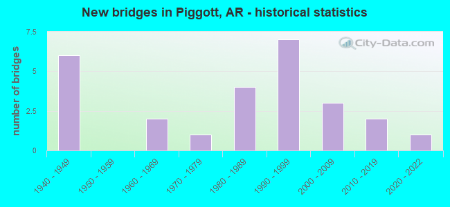
- New bridges - historical statistics
- 61940-1949
- 21960-1969
- 11970-1979
- 41980-1989
- 71990-1999
- 32000-2009
- 22010-2019
- 12020-2022


- Bridge Condition - Deck
- 5.6%Very good
- 77.8%Good
- 5.6%Satisfactory
- 11.1%Fair

- Bridge Condition - Superstructure
- 50.0%Good
- 50.0%Satisfactory

- Bridge Condition - Substructure
- 11.1%Very good
- 50.0%Good
- 11.1%Satisfactory
- 16.7%Fair
- 11.1%Poor

- Bridge Condition - Channel
- 3.8%Very good
- 38.5%Good
- 34.6%Satisfactory
- 15.4%Fair
- 7.7%Poor

- Bridge Condition - Culverts
- 12.5%Excellent
- 25.0%Very good
- 12.5%Good
- 50.0%Satisfactory
Find on map >> Show street view
Structure Number: 4275, Location: .75 E SH 139 (Lat: 36.345314, Lng: -90.143858), Route carried "on" structure: County highway 85, Year Built: 1975, Status: Open, Structure Length: 1.74m (5.71ft), Average Daily Traffic: 213 (year 2018), Truck Traffic: 1%, Average Future Daily Traffic: 124 (year 2007), Design Load: H 15, Features Intersected: RHYNE DITCH
Minimum Vertical Clearance: 30+ m (98+ ft), Kilometerpoint: 1.191, Lanes on structure: 2, Owner: County Highway Agency, Approaching Roadway Width: 9.1m (29.9ft), Material/Design: Concrete, Design/Construction: Channel Beam, Number Of Spans In Main Unit: 3, Length of Maximum Span: 5.8m (19.0ft), Curb or Sidewalk Widths: Left: 0.2m (0.7ft), Right: 0.2m (0.7ft), Curb-To-Curb Width: 8.0m (26.2ft), Out-to-Out Width: 8.3m (27.2ft)
Condition: Deck: Good, Superstructure: Satisfactory, Substructure: Good, Channel: Satisfactory, Operating Rating: 35.4 metric tons, Method Used To Determine Operating Rating: Load Factor (LF), Inventory Rating: 20.9 metric tons, Method Used To Determine Inventory Rating: Load Factor (LF), Structural Evaluation: Equal to present minimum criteria, Deck Geometry: Somewhat better than minimum adequacy, Waterway Adequacy: Equal to present desirable criteria, Approach Roadway Alignment: Equal to present desirable criteria, Designated Inspection Frequency: Every 24 months, Critical Feature Inspection Frequency: Every 24 months, Inspection Date: Febuary 2021, Deck Structure Type: Concrete Precast Panels, Wearing Surface/Protective System: Wearing Surface: Bituminous
Find on map >> Show street view
Structure Number: 4731, Location: .69 Mi SE of Piggott (Lat: 36.367211, Lng: -90.173881), Route carried "on" structure: County highway 80, Year Built: 1994, Status: Open, Structure Length: 4.10m (13.45ft), Average Daily Traffic: 85 (year 2018), Truck Traffic: 12%, Average Future Daily Traffic: 241 (year 2014), Design Load: HS 20, Features Intersected: BIG SLOUGH DITCH
Minimum Vertical Clearance: 30+ m (98+ ft), Kilometerpoint: 1.110, Lanes on structure: 2, Owner: County Highway Agency, Approaching Roadway Width: 8.5m (27.9ft), Skew: 3 degrees, Material/Design: Concrete, Design/Construction: Channel Beam, Number Of Spans In Main Unit: 5, Length of Maximum Span: 9.4m (30.8ft), Curb-To-Curb Width: 8.5m (27.9ft), Out-to-Out Width: 9.3m (30.5ft)
Condition: Deck: Good, Superstructure: Good, Substructure: Good, Channel: Satisfactory, Operating Rating: 54.4 metric tons, Method Used To Determine Operating Rating: Load Factor (LF), Inventory Rating: 32.7 metric tons, Method Used To Determine Inventory Rating: Load Factor (LF), Structural Evaluation: Better than present minimum criteria, Deck Geometry: Better than present minimum criteria, Waterway Adequacy: Equal to present desirable criteria, Approach Roadway Alignment: Better than present minimum criteria, Designated Inspection Frequency: Every 24 months, Critical Feature Inspection Frequency: Every 24 months, Inspection Date: Febuary 2022, Deck Structure Type: Concrete Precast Panels, Wearing Surface/Protective System: Wearing Surface: Monolithic Concrete
Find on map >> Show street view
Structure Number: 5251, Location: 1 MI S JCT US 62 & SH 139 (Lat: 36.367458, Lng: -90.157039), Route carried "on" structure: State highway 139, Year Built: 1968, Status: Open, Structure Length: 1.74m (5.71ft), Average Daily Traffic: 1,700 (year 2018), Truck Traffic: 6%, Average Future Daily Traffic: 1,929 (year 2028), Design Load: H 15, Features Intersected: DRAINAGE DITCH B
Minimum Vertical Clearance: 30+ m (98+ ft), Kilometerpoint: 11.974, Lanes on structure: 2, Owner: State Highway Agency, Approaching Roadway Width: 8.5m (27.9ft), Material/Design: Concrete, Design/Construction: Channel Beam, Number Of Spans In Main Unit: 3, Length of Maximum Span: 5.8m (19.0ft), Curb or Sidewalk Widths: Left: 0.1m (0.3ft), Right: 0.1m (0.3ft), Curb-To-Curb Width: 7.9m (25.9ft), Out-to-Out Width: 8.6m (28.2ft)
Condition: Deck: Good, Superstructure: Satisfactory, Substructure: Good, Channel: Good, Operating Rating: 54.4 metric tons, Method Used To Determine Operating Rating: Load Factor (LF), Inventory Rating: 32.7 metric tons, Method Used To Determine Inventory Rating: Load Factor (LF), Structural Evaluation: Equal to present minimum criteria, Deck Geometry: Meets minimum limits, Waterway Adequacy: Equal to present desirable criteria, Approach Roadway Alignment: Equal to present desirable criteria, Designated Inspection Frequency: Every 24 months, Critical Feature Inspection Frequency: Every 24 months, Inspection Date: January 2021, Deck Structure Type: Concrete Precast Panels, Wearing Surface/Protective System: Wearing Surface: Bituminous
Find on map >> Show street view
Structure Number: 5252, Location: 0.46 MI S JCT US 62 & 139 (Lat: 36.374747, Lng: -90.156989), Route carried "on" structure: State highway 139, Year Built: 1968, Status: Open, Structure Length: 1.74m (5.71ft), Average Daily Traffic: 1,700 (year 2018), Truck Traffic: 6%, Average Future Daily Traffic: 1,929 (year 2028), Design Load: H 15, Features Intersected: DRAINAGE DITCH C
Minimum Vertical Clearance: 30+ m (98+ ft), Kilometerpoint: 12.843, Lanes on structure: 2, Owner: State Highway Agency, Approaching Roadway Width: 8.5m (27.9ft), Material/Design: Concrete, Design/Construction: Channel Beam, Number Of Spans In Main Unit: 3, Length of Maximum Span: 5.8m (19.0ft), Curb or Sidewalk Widths: Left: 0.1m (0.3ft), Right: 0.1m (0.3ft), Curb-To-Curb Width: 7.9m (25.9ft), Out-to-Out Width: 8.6m (28.2ft)
Condition: Deck: Good, Superstructure: Satisfactory, Substructure: Good, Channel: Good, Operating Rating: 54.4 metric tons, Method Used To Determine Operating Rating: Load Factor (LF), Inventory Rating: 32.7 metric tons, Method Used To Determine Inventory Rating: Load Factor (LF), Structural Evaluation: Equal to present minimum criteria, Deck Geometry: Meets minimum limits, Waterway Adequacy: Equal to present desirable criteria, Approach Roadway Alignment: Equal to present desirable criteria, Designated Inspection Frequency: Every 24 months, Critical Feature Inspection Frequency: Every 24 months, Inspection Date: January 2021, Deck Structure Type: Concrete Precast Panels, Wearing Surface/Protective System: Wearing Surface: Bituminous
Find on map >> Show street view
Structure Number: 613, Location: 1.00 MI E JCT US 49 (Lat: 36.381811, Lng: -90.169661), Route carried "on" structure: US 62, Year Built: 1987, Status: Open, Structure Length: 5.55m (18.21ft), Average Daily Traffic: 4,156 (year 2018), Truck Traffic: 1%, Average Future Daily Traffic: 4,221 (year 2028), Design Load: HS 20, Features Intersected: BIG SLOUGH DITCH
Minimum Vertical Clearance: 30+ m (98+ ft), Kilometerpoint: 1.609, Lanes on structure: 2, Base Highway Network: Yes (Inventory Route: 622, Subroute: 1), Owner: State Highway Agency, Approaching Roadway Width: 14.6m (47.9ft), Material/Design: Steel, Design/Construction: Stringer/Multi-beam, Number Of Spans In Main Unit: 4, Length of Maximum Span: 13.7m (44.9ft), Curb-To-Curb Width: 12.2m (40.0ft), Out-to-Out Width: 13.0m (42.7ft)
Condition: Deck: Good, Superstructure: Satisfactory, Substructure: Good, Channel: Good, Operating Rating: 54.4 metric tons, Method Used To Determine Operating Rating: Load Factor (LF), Inventory Rating: 32.7 metric tons, Method Used To Determine Inventory Rating: Load Factor (LF), Structural Evaluation: Equal to present minimum criteria, Deck Geometry: Equal to present minimum criteria, Waterway Adequacy: Superior to present desirable criteria, Approach Roadway Alignment: Equal to present desirable criteria, Designated Inspection Frequency: Every 24 months, Critical Feature Inspection Frequency: Every 24 months, Inspection Date: Febuary 2022, Deck Structure Type: Concrete Cast-file-Place, Wearing Surface/Protective System: Wearing Surface: Monolithic Concrete
Find on map >> Show street view
Structure Number: 6227, Location: NW ON US 62 IN PIGGOTT (Lat: 36.389350, Lng: -90.197058), Route carried "on" structure: US 62, Year Built: 1989, Status: Open, Structure Length: 2.29m (7.51ft), Average Daily Traffic: 2,900 (year 2018), Truck Traffic: 1%, Average Future Daily Traffic: 2,532 (year 2028), Design Load: HS 20, Features Intersected: SUGAR CREEK
Minimum Vertical Clearance: 30+ m (98+ ft), Kilometerpoint: 40.185, Lanes on structure: 2, Base Highway Network: Yes (Inventory Route: 622, Subroute: 1), Owner: State Highway Agency, Approaching Roadway Width: 14.0m (45.9ft), Material/Design: Concrete, Design/Construction: Tee Beam, Number Of Spans In Main Unit: 3, Length of Maximum Span: 7.6m (24.9ft), Curb-To-Curb Width: 12.2m (40.0ft), Out-to-Out Width: 13.0m (42.7ft)
Condition: Deck: Good, Superstructure: Good, Substructure: Good, Channel: Good, Operating Rating: 54.4 metric tons, Method Used To Determine Operating Rating: Load Factor (LF), Inventory Rating: 32.7 metric tons, Method Used To Determine Inventory Rating: Load Factor (LF), Structural Evaluation: Better than present minimum criteria, Deck Geometry: Equal to present minimum criteria, Waterway Adequacy: Superior to present desirable criteria, Approach Roadway Alignment: Equal to present desirable criteria, Designated Inspection Frequency: Every 24 months, Critical Feature Inspection Frequency: Every 24 months, Inspection Date: June 2020, Deck Structure Type: Concrete Cast-file-Place, Wearing Surface/Protective System: Wearing Surface: Monolithic Concrete
Find on map >> Show street view
Structure Number: 6367, Location: 0.58 MI S OF JCT US 62 (Lat: 36.374500, Lng: -90.188681), Route carried "on" structure: US 49, Year Built: 1993, Status: Open, Structure Length: 2.29m (7.51ft), Average Daily Traffic: 1,400 (year 2018), Truck Traffic: 1%, Average Future Daily Traffic: 2,532 (year 2028), Design Load: HS 20, Features Intersected: SUGAR CREEK
Minimum Vertical Clearance: 30+ m (98+ ft), Kilometerpoint: 0.933, Lanes on structure: 2, Base Highway Network: Yes, Owner: State Highway Agency, Approaching Roadway Width: 12.2m (40.0ft), Material/Design: Concrete, Design/Construction: Tee Beam, Number Of Spans In Main Unit: 3, Length of Maximum Span: 7.6m (24.9ft), Curb-To-Curb Width: 12.2m (40.0ft), Out-to-Out Width: 13.0m (42.7ft)
Condition: Deck: Good, Superstructure: Good, Substructure: Good, Channel: Good, Operating Rating: 54.4 metric tons, Method Used To Determine Operating Rating: Load Factor (LF), Inventory Rating: 32.7 metric tons, Method Used To Determine Inventory Rating: Load Factor (LF), Structural Evaluation: Better than present minimum criteria, Deck Geometry: Better than present minimum criteria, Waterway Adequacy: Equal to present desirable criteria, Approach Roadway Alignment: Equal to present desirable criteria, Designated Inspection Frequency: Every 24 months, Critical Feature Inspection Frequency: Every 24 months, Inspection Date: June 2021, Deck Structure Type: Concrete Cast-file-Place, Wearing Surface/Protective System: Wearing Surface: Monolithic Concrete
Find on map >> Show street view
Structure Number: 17838, Location: 4 W PIGGOTT (Lat: 36.375200, Lng: -90.261669), Route carried "on" structure: County highway 53, Year Built: 1941, Status: Posted for load, Structure Length: 0.98m (3.22ft), Average Daily Traffic: 889 (year 2018), Truck Traffic: 1%, Average Future Daily Traffic: 147 (year 2007), Features Intersected: DITCH
Minimum Vertical Clearance: 30+ m (98+ ft), Kilometerpoint: 13.406, Lanes on structure: 2, Owner: County Highway Agency, Approaching Roadway Width: 5.8m (19.0ft), Skew: 1 degrees, Material/Design: Steel, Design/Construction: Stringer/Multi-beam, Number Of Spans In Main Unit: 1, Length of Maximum Span: 9.4m (30.8ft), Curb or Sidewalk Widths: Left: 0.2m (0.7ft), Right: 0.2m (0.7ft), Curb-To-Curb Width: 6.7m (22.0ft), Out-to-Out Width: 7.0m (23.0ft)
Condition: Deck: Good, Superstructure: Satisfactory, Substructure: Satisfactory, Channel: Satisfactory, Operating Rating: 20.9 metric tons, Method Used To Determine Operating Rating: Load Factor (LF), Inventory Rating: 12.7 metric tons, Method Used To Determine Inventory Rating: Load Factor (LF), Structural Evaluation: Meets minimum limits, Deck Geometry: Meets minimum limits, Waterway Adequacy: Equal to present minimum criteria, Approach Roadway Alignment: Better than present minimum criteria, Bridge Posting: Required (Relationship of Operating Rating to Maximum Legal Load: > 39.9% below), Length Of Structure Improvement: 0.98m (3.22ft), Designated Inspection Frequency: Every 24 months, Critical Feature Inspection Frequency: Every 24 months, Inspection Date: November 2021, Total Project Cost: $33,000, Deck Structure Type: Concrete Cast-file-Place, Wearing Surface/Protective System: Wearing Surface: Gravel
Find on map >> Show street view
Structure Number: 19048, Location: 0.12 Mi S Jct US 62 (Lat: 36.380153, Lng: -90.191794), Route carried "on" structure: City street 21341, Year Built: 1942, Status: Open, Structure Length: 1.31m (4.30ft), Average Daily Traffic: 336 (year 2018), Truck Traffic: 1%, Average Future Daily Traffic: 1,798 (year 2007), Features Intersected: SUGAR CREEK, Facility Carried by Structure: SO FRONT AVE- I
Minimum Vertical Clearance: 30+ m (98+ ft), Kilometerpoint: 0.241, Lanes on structure: 2, Owner: City or Municipal Highway Agency, Approaching Roadway Width: 8.5m (27.9ft), Material/Design: Concrete, Design/Construction: Culvert, Number Of Spans In Main Unit: 4, Length of Maximum Span: 3.4m (11.2ft), Curb-To-Curb Width: 8.5m (27.9ft), Out-to-Out Width: 9.2m (30.2ft)
Condition: Channel: Satisfactory, Culverts: Satisfactory, Operating Rating: 42.6 metric tons, Method Used To Determine Operating Rating: Load Factor (LF), Inventory Rating: 25.4 metric tons, Method Used To Determine Inventory Rating: Load Factor (LF), Structural Evaluation: Equal to present minimum criteria, Deck Geometry: Equal to present minimum criteria, Waterway Adequacy: Somewhat better than minimum adequacy, Approach Roadway Alignment: Equal to present desirable criteria, Designated Inspection Frequency: Every 24 months, Critical Feature Inspection Frequency: Every 24 months, Inspection Date: December 2020, Wearing Surface/Protective System: Wearing Surface: Bituminous
Find on map >> Show street view
Structure Number: 19049, Location: 0.25 Mi W Jct US 62 (Lat: 36.385011, Lng: -90.196050), Route carried "on" structure: City street 10580, Year Built: 1942, Status: Open, Structure Length: 0.99m (3.25ft), Average Daily Traffic: 759 (year 2018), Truck Traffic: 1%, Average Future Daily Traffic: 539 (year 2007), Features Intersected: SUGAR CREEK, Facility Carried by Structure: W CHERRY ST.
Minimum Vertical Clearance: 30+ m (98+ ft), Kilometerpoint: 0.595, Lanes on structure: 2, Owner: City or Municipal Highway Agency, Approaching Roadway Width: 8.8m (28.9ft), Skew: 1 degrees, Material/Design: Concrete, Design/Construction: Culvert, Number Of Spans In Main Unit: 3, Length of Maximum Span: 3.4m (11.2ft), Curb or Sidewalk Widths: Left: 1.2m (3.9ft), Right: 1.2m (3.9ft), Curb-To-Curb Width: 8.8m (28.9ft), Out-to-Out Width: 11.7m (38.4ft)
Condition: Channel: Fair, Culverts: Satisfactory, Operating Rating: 26.3 metric tons, Method Used To Determine Operating Rating: Load Factor (LF), Inventory Rating: 16.3 metric tons, Method Used To Determine Inventory Rating: Load Factor (LF), Structural Evaluation: Meets minimum limits, Deck Geometry: Somewhat better than minimum adequacy, Waterway Adequacy: Better than present minimum criteria, Approach Roadway Alignment: Equal to present desirable criteria, Designated Inspection Frequency: Every 24 months, Critical Feature Inspection Frequency: Every 24 months, Inspection Date: November 2021, Deck Structure Type: Concrete Cast-file-Place, Wearing Surface/Protective System: Wearing Surface: Bituminous
Find on map >> Show street view
Structure Number: 1905, Location: 0.2 Mi W & S Jct US 62 (Lat: 36.383031, Lng: -90.195547), Route carried "on" structure: City street 13280, Year Built: 1942, Status: Open, Structure Length: 0.98m (3.22ft), Average Daily Traffic: 557 (year 2018), Truck Traffic: 1%, Average Future Daily Traffic: 2,999 (year 2007), Features Intersected: SUGAR CREEK, Facility Carried by Structure: W COURT ST.
Minimum Vertical Clearance: 30+ m (98+ ft), Kilometerpoint: 0.837, Lanes on structure: 2, Owner: City or Municipal Highway Agency, Approaching Roadway Width: 8.8m (28.9ft), Material/Design: Concrete, Design/Construction: Culvert, Number Of Spans In Main Unit: 3, Length of Maximum Span: 3.4m (11.2ft), Curb or Sidewalk Widths: Left: 1.2m (3.9ft), Right: 1.2m (3.9ft), Curb-To-Curb Width: 8.6m (28.2ft), Out-to-Out Width: 11.9m (39.0ft)
Condition: Channel: Fair, Culverts: Satisfactory, Operating Rating: 29.9 metric tons, Method Used To Determine Operating Rating: Load Factor (LF), Inventory Rating: 18.1 metric tons, Method Used To Determine Inventory Rating: Load Factor (LF), Structural Evaluation: Somewhat better than minimum adequacy, Deck Geometry: Somewhat better than minimum adequacy, Waterway Adequacy: Equal to present minimum criteria, Approach Roadway Alignment: Equal to present desirable criteria, Designated Inspection Frequency: Every 24 months, Critical Feature Inspection Frequency: Every 24 months, Inspection Date: March 2021, Deck Structure Type: Concrete Cast-file-Place, Wearing Surface/Protective System: Wearing Surface: Bituminous
Find on map >> Show street view
Structure Number: 19051, Location: 0.25 Mi W Jct US 62 (Lat: 36.384019, Lng: -90.196239), Route carried "on" structure: City street 61545, Year Built: 1942, Status: Open, Structure Length: 0.98m (3.22ft), Average Daily Traffic: 513 (year 2018), Truck Traffic: 1%, Average Future Daily Traffic: 1,437 (year 2007), Features Intersected: SUGAR CREEK, Facility Carried by Structure: W MAIN ST.
Minimum Vertical Clearance: 30+ m (98+ ft), Kilometerpoint: 0.338, Lanes on structure: 2, Owner: City or Municipal Highway Agency, Approaching Roadway Width: 10.7m (35.1ft), Material/Design: Concrete, Design/Construction: Culvert, Number Of Spans In Main Unit: 3, Length of Maximum Span: 3.4m (11.2ft), Curb or Sidewalk Widths: Left: 0.0m, Right: 1.2m (3.9ft), Curb-To-Curb Width: 10.5m (34.4ft), Out-to-Out Width: 11.9m (39.0ft)
Condition: Channel: Fair, Culverts: Satisfactory, Operating Rating: 29.9 metric tons, Method Used To Determine Operating Rating: Load Factor (LF), Inventory Rating: 18.1 metric tons, Method Used To Determine Inventory Rating: Load Factor (LF), Structural Evaluation: Somewhat better than minimum adequacy, Deck Geometry: Equal to present minimum criteria, Waterway Adequacy: Meets minimum limits, Approach Roadway Alignment: Equal to present desirable criteria, Designated Inspection Frequency: Every 24 months, Critical Feature Inspection Frequency: Every 24 months, Inspection Date: March 2021
Find on map >> Show street view
Structure Number: 21467, Location: .63 M W of CR 341 (Lat: 36.454536, Lng: -90.206903), Route carried "on" structure: County highway 223, Year Built: 1994, Year Reconstructed: 1998, Status: Posted for load, Structure Length: 1.87m (6.14ft), Average Daily Traffic: 36 (year 2018), Truck Traffic: 1%, Average Future Daily Traffic: 28 (year 2007), Features Intersected: POPLAR CREEK
Minimum Vertical Clearance: 30+ m (98+ ft), Kilometerpoint: 1.014, Lanes on structure: 1, Owner: County Highway Agency, Approaching Roadway Width: 5.5m (18.0ft), Material/Design: Steel, Design/Construction: Stringer/Multi-beam, Number Of Spans In Main Unit: 1, Length of Maximum Span: 17.9m (58.7ft), Curb or Sidewalk Widths: Left: 0.2m (0.7ft), Right: 0.2m (0.7ft), Curb-To-Curb Width: 4.6m (15.1ft), Out-to-Out Width: 4.9m (16.1ft)
Condition: Deck: Fair, Superstructure: Satisfactory, Substructure: Poor, Channel: Poor, Operating Rating: 21.8 metric tons, Method Used To Determine Operating Rating: Load Factor (LF), Inventory Rating: 12.7 metric tons, Method Used To Determine Inventory Rating: Load Factor (LF), Structural Evaluation: Meets minimum limits, Deck Geometry: Better than present minimum criteria, Waterway Adequacy: Equal to present minimum criteria, Approach Roadway Alignment: Somewhat better than minimum adequacy, Bridge Posting: Required (Relationship of Operating Rating to Maximum Legal Load: > 39.9% below), Designated Inspection Frequency: Every 24 months, Critical Feature Inspection Frequency: Every 24 months, Other Special Inspection Frequency: Every 24 months, Inspection Date: March 2021, Other Special Inspection Date: September 2021, Deck Structure Type: Wood or Timber, Wearing Surface/Protective System: Wearing Surface: Wood or Timber
Find on map >> Show street view
Structure Number: 21555, Location: 2.18 Mi SW of Hwy 62 (Lat: 36.422589, Lng: -90.169975), Route carried "on" structure: County highway 204, Year Built: 1995, Year Reconstructed: 2001, Status: Posted for load, Structure Length: 1.83m (6.00ft), Average Daily Traffic: 41 (year 2018), Truck Traffic: 1%, Average Future Daily Traffic: 110 (year 2007), Features Intersected: MCNEIL CREEK
Minimum Vertical Clearance: 30+ m (98+ ft), Kilometerpoint: 0.467, Lanes on structure: 1, Owner: County Highway Agency, Approaching Roadway Width: 4.3m (14.1ft), Material/Design: Steel, Design/Construction: Stringer/Multi-beam, Number Of Spans In Main Unit: 1, Length of Maximum Span: 18.0m (59.1ft), Curb or Sidewalk Widths: Left: 0.2m (0.7ft), Right: 0.2m (0.7ft), Curb-To-Curb Width: 4.5m (14.8ft), Out-to-Out Width: 4.9m (16.1ft)
Condition: Deck: Fair, Superstructure: Satisfactory, Substructure: Poor, Channel: Satisfactory, Operating Rating: 18.1 metric tons, Method Used To Determine Operating Rating: Load Factor (LF), Inventory Rating: 10.9 metric tons, Method Used To Determine Inventory Rating: Load Factor (LF), Structural Evaluation: Meets minimum limits, Deck Geometry: Equal to present minimum criteria, Waterway Adequacy: Equal to present minimum criteria, Approach Roadway Alignment: Equal to present minimum criteria, Bridge Posting: Required (Relationship of Operating Rating to Maximum Legal Load: > 39.9% below), Designated Inspection Frequency: Every 24 months, Critical Feature Inspection Frequency: Every 24 months, Inspection Date: March 2021, Deck Structure Type: Wood or Timber, Wearing Surface/Protective System: Wearing Surface: Wood or Timber
Find on map >> Show street view
Structure Number: 21955, Location: .75 MI N,3.5 MI E POLLARD (Lat: 36.440047, Lng: -90.207864), Route carried "on" structure: County highway 94, Year Built: 1998, Status: Posted for load, Structure Length: 1.83m (6.00ft), Average Daily Traffic: 224 (year 2018), Truck Traffic: 5%, Average Future Daily Traffic: 89 (year 2007), Features Intersected: CREEK
Minimum Vertical Clearance: 30+ m (98+ ft), Kilometerpoint: 3.428, Lanes on structure: 1, Owner: County Highway Agency, Approaching Roadway Width: 4.0m (13.1ft), Material/Design: Steel, Design/Construction: Stringer/Multi-beam, Number Of Spans In Main Unit: 1, Length of Maximum Span: 18.1m (59.4ft), Curb or Sidewalk Widths: Left: 0.2m (0.7ft), Right: 0.2m (0.7ft), Curb-To-Curb Width: 4.5m (14.8ft), Out-to-Out Width: 4.9m (16.1ft)
Condition: Deck: Satisfactory, Superstructure: Satisfactory, Substructure: Fair, Channel: Poor, Operating Rating: 21.8 metric tons, Method Used To Determine Operating Rating: Load Factor (LF), Inventory Rating: 13.6 metric tons, Method Used To Determine Inventory Rating: Load Factor (LF), Structural Evaluation: Meets minimum limits, Deck Geometry: High priority of replacement, Waterway Adequacy: Better than present minimum criteria, Approach Roadway Alignment: Equal to present minimum criteria, Bridge Posting: Required (Relationship of Operating Rating to Maximum Legal Load: > 39.9% below), Designated Inspection Frequency: Every 24 months, Critical Feature Inspection Frequency: Every 24 months, Inspection Date: March 2021, Deck Structure Type: Wood or Timber, Wearing Surface/Protective System: Wearing Surface: Wood or Timber
Find on map >> Show street view
Structure Number: 21965, Location: .74 Mi W of Hwy 62 (Lat: 36.418347, Lng: -90.160942), Route carried "on" structure: County highway 93, Year Built: 1998, Status: Posted for load, Structure Length: 1.83m (6.00ft), Average Daily Traffic: 217 (year 2018), Truck Traffic: 1%, Average Future Daily Traffic: 31 (year 2007), Features Intersected: BIG SLOUGH DITCH, Facility Carried by Structure: CR 63-C 911=344
Minimum Vertical Clearance: 30+ m (98+ ft), Kilometerpoint: 5.086, Lanes on structure: 1, Owner: County Highway Agency, Approaching Roadway Width: 4.9m (16.1ft), Material/Design: Steel, Design/Construction: Stringer/Multi-beam, Number Of Spans In Main Unit: 1, Length of Maximum Span: 17.4m (57.1ft), Curb or Sidewalk Widths: Left: 0.2m (0.7ft), Right: 0.2m (0.7ft), Curb-To-Curb Width: 5.2m (17.1ft), Out-to-Out Width: 5.5m (18.0ft)
Condition: Deck: Good, Superstructure: Satisfactory, Substructure: Fair, Channel: Fair, Operating Rating: 26.3 metric tons, Method Used To Determine Operating Rating: Load Factor (LF), Inventory Rating: 15.4 metric tons, Method Used To Determine Inventory Rating: Load Factor (LF), Structural Evaluation: Meets minimum limits, Deck Geometry: High priority of replacement, Waterway Adequacy: Equal to present minimum criteria, Approach Roadway Alignment: Equal to present minimum criteria, Bridge Posting: Required (Relationship of Operating Rating to Maximum Legal Load: 30.0 - 39.9% below), Designated Inspection Frequency: Every 24 months, Critical Feature Inspection Frequency: Every 24 months, Inspection Date: March 2021, Deck Structure Type: Other, Wearing Surface/Protective System: Wearing Surface: Other
Find on map >> Show street view
Structure Number: 22038, Location: JCT CLAY ST & HOUSTON AVE (Lat: 36.381950, Lng: -90.195131), Route carried "on" structure: City street 11560, Year Built: 1949, Year Reconstructed: 1997, Status: Open, Structure Length: 0.70m (2.30ft), Average Daily Traffic: 661 (year 2018), Truck Traffic: 2%, Average Future Daily Traffic: 121 (year 2017), Features Intersected: CREEK, Facility Carried by Structure: W CLAY ST. -SEC- I
Minimum Vertical Clearance: 30+ m (98+ ft), Kilometerpoint: 20.278, Lanes on structure: 2, Owner: City or Municipal Highway Agency, Approaching Roadway Width: 6.4m (21.0ft), Material/Design: Concrete, Design/Construction: Culvert, Number Of Spans In Main Unit: 2, Length of Maximum Span: 3.3m (10.8ft), Curb or Sidewalk Widths: Left: 0.3m (1.0ft), Right: 1.4m (4.6ft), Curb-To-Curb Width: 7.6m (24.9ft), Out-to-Out Width: 9.3m (30.5ft)
Condition: Channel: Good, Culverts: Good, Operating Rating: 26.3 metric tons, Method Used To Determine Operating Rating: Load Factor (LF), Inventory Rating: 16.3 metric tons, Method Used To Determine Inventory Rating: Load Factor (LF), Structural Evaluation: Meets minimum limits, Deck Geometry: Meets minimum limits, Waterway Adequacy: Better than present minimum criteria, Approach Roadway Alignment: Equal to present desirable criteria, Designated Inspection Frequency: Every 24 months, Critical Feature Inspection Frequency: Every 24 months, Inspection Date: November 2020, Wearing Surface/Protective System: Wearing Surface: Bituminous
Find on map >> Show street view
Structure Number: 22242, Location: 0.1 MI. SO OF W. CLAY ST (Lat: 36.380917, Lng: -90.196617), Route carried "on" structure: City street 64552, Year Built: 1980, Status: Open, Structure Length: 0.76m (2.49ft), Average Daily Traffic: 166 (year 2018), Truck Traffic: 1%, Average Future Daily Traffic: 362 (year 2020), Features Intersected: CREEK, Facility Carried by Structure: SO. 7TH AVE.-I
Minimum Vertical Clearance: 30+ m (98+ ft), Kilometerpoint: 0.209, Lanes on structure: 2, Owner: City or Municipal Highway Agency, Approaching Roadway Width: 6.1m (20.0ft), Material/Design: Steel, Design/Construction: Stringer/Multi-beam, Number Of Spans In Main Unit: 1, Length of Maximum Span: 7.3m (24.0ft), Curb or Sidewalk Widths: Left: 0.2m (0.7ft), Right: 0.2m (0.7ft), Curb-To-Curb Width: 6.0m (19.7ft), Out-to-Out Width: 6.5m (21.3ft)
Condition: Deck: Good, Superstructure: Good, Substructure: Good, Channel: Satisfactory, Operating Rating: 54.4 metric tons, Method Used To Determine Operating Rating: Load Factor (LF), Inventory Rating: 32.7 metric tons, Method Used To Determine Inventory Rating: Load Factor (LF), Structural Evaluation: Better than present minimum criteria, Deck Geometry: High priority of corrective action, Waterway Adequacy: Better than present minimum criteria, Approach Roadway Alignment: Better than present minimum criteria, Length Of Structure Improvement: 1.46m (4.79ft), Designated Inspection Frequency: Every 24 months, Critical Feature Inspection Frequency: Every 24 months, Inspection Date: November 2020, Roadway Improvement Cost: $109,000, Total Project Cost: $208,000, Deck Structure Type: Concrete Cast-file-Place, Wearing Surface/Protective System: Wearing Surface: Bituminous
Find on map >> Show street view
Structure Number: 22243, Location: .04 SO. OF W. CLAY ST. (Lat: 36.381422, Lng: -90.198822), Route carried "on" structure: City street 64592, Year Built: 1980, Status: Open, Structure Length: 0.94m (3.08ft), Average Daily Traffic: 563 (year 2018), Truck Traffic: 1%, Average Future Daily Traffic: 362 (year 2020), Features Intersected: CREEK, Facility Carried by Structure: SO. 9TH AVE.-I
Minimum Vertical Clearance: 30+ m (98+ ft), Kilometerpoint: 0.241, Lanes on structure: 2, Owner: City or Municipal Highway Agency, Approaching Roadway Width: 6.1m (20.0ft), Material/Design: Concrete, Design/Construction: Channel Beam, Number Of Spans In Main Unit: 1, Length of Maximum Span: 9.1m (29.9ft), Curb-To-Curb Width: 7.3m (24.0ft), Out-to-Out Width: 7.7m (25.3ft)
Condition: Deck: Very good, Superstructure: Good, Substructure: Very good, Channel: Satisfactory, Operating Rating: 54.4 metric tons, Method Used To Determine Operating Rating: Load Factor (LF), Inventory Rating: 32.7 metric tons, Method Used To Determine Inventory Rating: Load Factor (LF), Structural Evaluation: Better than present minimum criteria, Deck Geometry: Meets minimum limits, Waterway Adequacy: Equal to present minimum criteria, Approach Roadway Alignment: Better than present minimum criteria, Designated Inspection Frequency: Every 24 months, Critical Feature Inspection Frequency: Every 24 months, Inspection Date: November 2020, Deck Structure Type: Concrete Precast Panels, Wearing Surface/Protective System: Wearing Surface: Bituminous
Find on map >> Show street view
Structure Number: 22244, Location: 15' S. OF W. CLAY ST. (Lat: 36.382031, Lng: -90.200400), Route carried "on" structure: City street 64613, Year Built: 1990, Status: Open, Structure Length: 0.76m (2.49ft), Average Daily Traffic: 2,400 (year 2018), Truck Traffic: 1%, Average Future Daily Traffic: 362 (year 2020), Features Intersected: CREEK, Facility Carried by Structure: SO. 10TH AVE-I
Minimum Vertical Clearance: 30+ m (98+ ft), Kilometerpoint: 0.161, Lanes on structure: 2, Owner: City or Municipal Highway Agency, Approaching Roadway Width: 6.1m (20.0ft), Material/Design: Steel, Design/Construction: Stringer/Multi-beam, Number Of Spans In Main Unit: 1, Length of Maximum Span: 7.3m (24.0ft), Curb or Sidewalk Widths: Left: 0.2m (0.7ft), Right: 0.2m (0.7ft), Curb-To-Curb Width: 6.0m (19.7ft), Out-to-Out Width: 6.6m (21.7ft)
Condition: Deck: Good, Superstructure: Good, Substructure: Very good, Channel: Good, Operating Rating: 54.4 metric tons, Method Used To Determine Operating Rating: Load Factor (LF), Inventory Rating: 32.7 metric tons, Method Used To Determine Inventory Rating: Load Factor (LF), Structural Evaluation: Better than present minimum criteria, Deck Geometry: High priority of replacement, Waterway Adequacy: Better than present minimum criteria, Approach Roadway Alignment: Equal to present minimum criteria, Length Of Structure Improvement: 1.46m (4.79ft), Designated Inspection Frequency: Every 24 months, Critical Feature Inspection Frequency: Every 24 months, Inspection Date: November 2020, Roadway Improvement Cost: $109,000, Total Project Cost: $208,000, Deck Structure Type: Concrete Cast-file-Place, Wearing Surface/Protective System: Wearing Surface: Monolithic Concrete
Find on map >> Show street view
Structure Number: 22808, Location: 0.91 Mi W of Hwy 62 (Lat: 36.403922, Lng: -90.164253), Route carried "on" structure: County highway 90, Year Built: 2004, Status: Posted for load, Structure Length: 2.35m (7.71ft), Average Daily Traffic: 173 (year 2018), Truck Traffic: 1%, Average Future Daily Traffic: 100 (year 2017), Features Intersected: SLOUGH DITCH
Minimum Vertical Clearance: 30+ m (98+ ft), Kilometerpoint: 1.465, Lanes on structure: 2, Owner: County Highway Agency, Approaching Roadway Width: 5.5m (18.0ft), Material/Design: Steel, Design/Construction: Stringer/Multi-beam, Number Of Spans In Main Unit: 2, Length of Maximum Span: 14.3m (46.9ft), Curb or Sidewalk Widths: Left: 0.2m (0.7ft), Right: 0.2m (0.7ft), Curb-To-Curb Width: 5.9m (19.4ft), Out-to-Out Width: 6.2m (20.3ft)
Condition: Deck: Good, Superstructure: Good, Substructure: Fair, Channel: Satisfactory, Operating Rating: 20.9 metric tons, Method Used To Determine Operating Rating: Load Factor (LF), Inventory Rating: 12.7 metric tons, Method Used To Determine Inventory Rating: Load Factor (LF), Structural Evaluation: Meets minimum limits, Deck Geometry: High priority of corrective action, Waterway Adequacy: Better than present minimum criteria, Approach Roadway Alignment: Somewhat better than minimum adequacy, Bridge Posting: Required (Relationship of Operating Rating to Maximum Legal Load: > 39.9% below), Designated Inspection Frequency: Every 24 months, Inspection Date: March 2021, Deck Structure Type: Other, Wearing Surface/Protective System: Wearing Surface: Other
Find on map >> Show street view
Structure Number: 22812, Location: .25 Mi N of Hwy 49 (Lat: 36.378119, Lng: -90.188769), Route carried "on" structure: City street 7390, Year Built: 2004, Status: Open, Structure Length: 1.54m (5.05ft), Average Daily Traffic: 208 (year 2018), Truck Traffic: 1%, Average Future Daily Traffic: 262 (year 2007), Features Intersected: SUGAR CREEK, Facility Carried by Structure: S. BROWNING AVE-I
Minimum Vertical Clearance: 30+ m (98+ ft), Kilometerpoint: 0.402, Lanes on structure: 2, Owner: City or Municipal Highway Agency, Approaching Roadway Width: 6.4m (21.0ft), Material/Design: Steel, Design/Construction: Stringer/Multi-beam, Number Of Spans In Main Unit: 1, Length of Maximum Span: 14.6m (47.9ft), Curb-To-Curb Width: 6.5m (21.3ft), Out-to-Out Width: 6.7m (22.0ft)
Condition: Deck: Good, Superstructure: Good, Substructure: Good, Channel: Good, Operating Rating: 39.0 metric tons, Method Used To Determine Operating Rating: Load Factor (LF), Inventory Rating: 23.6 metric tons, Method Used To Determine Inventory Rating: Load Factor (LF), Structural Evaluation: Equal to present minimum criteria, Deck Geometry: Meets minimum limits, Waterway Adequacy: Equal to present desirable criteria, Approach Roadway Alignment: Better than present minimum criteria, Designated Inspection Frequency: Every 24 months, Critical Feature Inspection Frequency: Every 24 months, Inspection Date: November 2021, Deck Structure Type: Other
Find on map >> Show street view
Structure Number: 22814, Location: 1.0 MI. E OF GREENWAY (Lat: 36.345350, Lng: -90.197967), Route carried "on" structure: County highway 83, Year Built: 2004, Status: Posted for load, Structure Length: 2.22m (7.28ft), Average Daily Traffic: 18 (year 2018), Truck Traffic: 1%, Average Future Daily Traffic: 100 (year 2007), Features Intersected: QUICK CREEK
Minimum Vertical Clearance: 30+ m (98+ ft), Kilometerpoint: 0.789, Lanes on structure: 2, Owner: County Highway Agency, Approaching Roadway Width: 5.5m (18.0ft), Material/Design: Steel, Design/Construction: Stringer/Multi-beam, Number Of Spans In Main Unit: 2, Length of Maximum Span: 14.6m (47.9ft), Curb or Sidewalk Widths: Left: 0.2m (0.7ft), Right: 0.2m (0.7ft), Curb-To-Curb Width: 5.8m (19.0ft), Out-to-Out Width: 6.1m (20.0ft)
Condition: Deck: Good, Superstructure: Good, Substructure: Satisfactory, Channel: Satisfactory, Operating Rating: 29.0 metric tons, Method Used To Determine Operating Rating: Load Factor (LF), Inventory Rating: 17.2 metric tons, Method Used To Determine Inventory Rating: Load Factor (LF), Structural Evaluation: Somewhat better than minimum adequacy, Deck Geometry: Meets minimum limits, Waterway Adequacy: Better than present minimum criteria, Approach Roadway Alignment: Somewhat better than minimum adequacy, Bridge Posting: Required (Relationship of Operating Rating to Maximum Legal Load: 20.0 - 29.9% below), Designated Inspection Frequency: Every 24 months, Critical Feature Inspection Frequency: Every 24 months, Inspection Date: August 2021, Deck Structure Type: Other, Wearing Surface/Protective System: Wearing Surface: Other
Find on map >> Show street view
Structure Number: 2357, Location: 3.7 W of Piggott (Lat: 36.375147, Lng: -90.251050), Route carried "on" structure: County highway 53, Year Built: 2016, Status: Open, Structure Length: 0.90m (2.95ft), Average Daily Traffic: 889 (year 2018), Truck Traffic: 1%, Average Future Daily Traffic: 373 (year 2007), Design Load: HL 93, Features Intersected: Creek
Minimum Vertical Clearance: 30.44m (99.87ft), Kilometerpoint: 14.629, Lanes on structure: 2, Owner: County Highway Agency, Approaching Roadway Width: 6.7m (22.0ft), Skew: 2 degrees, Material/Design: Steel, Design/Construction: Culvert, Number Of Spans In Main Unit: 3, Length of Maximum Span: 2.4m (7.9ft)
Condition: Channel: Good, Culverts: Very good, Operating Rating: 54.4 metric tons, Method Used To Determine Operating Rating: Load and Resistance Factor (LRFR), Inventory Rating: 32.7 metric tons, Method Used To Determine Inventory Rating: Load and Resistance Factor (LRFR), Structural Evaluation: Equal to present desirable criteria, Waterway Adequacy: Equal to present desirable criteria, Approach Roadway Alignment: Equal to present desirable criteria, Designated Inspection Frequency: Every 24 months, Critical Feature Inspection Frequency: Every 24 months, Inspection Date: December 2020
Find on map >> Show street view
Structure Number: 23571, Location: 2 W of Piggott (Lat: 36.377458, Lng: -90.222908), Route carried "on" structure: County highway 53, Year Built: 2016, Status: Open, Structure Length: 1.07m (3.51ft), Average Daily Traffic: 889 (year 2018), Truck Traffic: 1%, Average Future Daily Traffic: 373 (year 2007), Design Load: HL 93, Features Intersected: Creek
Minimum Vertical Clearance: 30+ m (98+ ft), Kilometerpoint: 17.461, Lanes on structure: 2, Owner: County Highway Agency, Approaching Roadway Width: 6.7m (22.0ft), Skew: 4 degrees, Material/Design: Steel, Design/Construction: Culvert, Number Of Spans In Main Unit: 3, Length of Maximum Span: 2.1m (6.9ft)
Condition: Channel: Good, Culverts: Very good, Operating Rating: 54.4 metric tons, Method Used To Determine Operating Rating: Load and Resistance Factor (LRFR), Inventory Rating: 32.7 metric tons, Method Used To Determine Inventory Rating: Load and Resistance Factor (LRFR), Structural Evaluation: Equal to present desirable criteria, Waterway Adequacy: Equal to present minimum criteria, Approach Roadway Alignment: Equal to present desirable criteria, Designated Inspection Frequency: Every 24 months, Critical Feature Inspection Frequency: Every 24 months, Inspection Date: December 2020
Find on map >> Show street view
Structure Number: X1634, Location: 2 Miles E of Piggott (Lat: 36.381839, Lng: -90.143989), Route carried "on" structure: State highway 1, Year Built: 2021, Status: Open, Structure Length: 1.02m (3.35ft), Average Daily Traffic: 620 (year 2020), Truck Traffic: 7%, Average Future Daily Traffic: 700 (year 2040), Design Load: HL 93, Features Intersected: Big Slough Ditch Branch
Minimum Vertical Clearance: 30+ m (98+ ft), Kilometerpoint: 0.724, Lanes on structure: 2, Owner: State Highway Agency, Approaching Roadway Width: 7.9m (25.9ft), Material/Design: Concrete, Design/Construction: Culvert, Number Of Spans In Main Unit: 3, Length of Maximum Span: 3.6m (11.8ft)
Condition: Channel: Very good, Culverts: Excellent, Operating Rating: 54.4 metric tons, Method Used To Determine Operating Rating: Load and Resistance Factor (LRFR), Inventory Rating: 32.7 metric tons, Method Used To Determine Inventory Rating: Load and Resistance Factor (LRFR), Structural Evaluation: Superior to present desirable criteria, Waterway Adequacy: Better than present minimum criteria, Approach Roadway Alignment: Equal to present desirable criteria, Designated Inspection Frequency: Every 24 months, Critical Feature Inspection Frequency: Every 24 months, Inspection Date: October 2021, Wearing Surface/Protective System: Wearing Surface: Bituminous