Bridge Statistics for Pikeville, Tennessee (TN)
Condition, Traffic, Stress, Structural Evaluation, Project Costs
- National Bridge Inventory (NBI) Statistics
- 25Number of bridges
- 200ft / 60.9mTotal length
- $5,014,000Total costs
- 70,071Total average daily traffic
- 7,096Total average daily truck traffic
- 102,048Total future (year 2040) average daily traffic
- National Bridge Inventory (NBI) Registered Bridges for Pikeville
- No street view available for this location
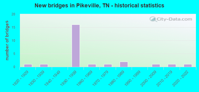
- New bridges - historical statistics
- 11920-1929
- 11930-1939
- 161950-1959
- 11960-1969
- 11970-1979
- 21980-1989
- 12000-2009
- 12010-2019
- 12020-2022

- Reconstructed bridges - Historical Statistics
- 11990-1999
- 12000-2009


- Bridge Condition - Deck
- 33.3%Good
- 50.0%Satisfactory
- 16.7%Fair

- Bridge Condition - Superstructure
- 16.7%Good
- 50.0%Satisfactory
- 33.3%Fair

- Bridge Condition - Substructure
- 50.0%Good
- 16.7%Satisfactory
- 33.3%Fair

- Bridge Condition - Channel
- 4.0%Very good
- 32.0%Good
- 40.0%Satisfactory
- 20.0%Fair
- 4.0%Poor

- Bridge Condition - Culverts
- 73.7%Good
- 21.1%Satisfactory
- 5.3%Fair
Find on map >> Show street view
Structure Number: 4011340007, Location: 2MI EAST OF US 127 (Lat: 35.528386, Lng: -85.231228), Route carried "on" structure: County highway 1134, Year Built: 1954, Status: Open, Structure Length: 0.88m (2.89ft), Average Daily Traffic: 420 (year 2020), Truck Traffic: 3%, Average Future Daily Traffic: 624 (year 2040), Design Load: H 15, Features Intersected: BRANCH
Minimum Vertical Clearance: 30+ m (98+ ft), Kilometerpoint: 25.862, Lanes on structure: 2, Owner: County Highway Agency, Approaching Roadway Width: 7.3m (24.0ft), Material/Design: Concrete continuous, Design/Construction: Culvert, Number Of Spans In Main Unit: 2, Length of Maximum Span: 3.7m (12.1ft), Curb-To-Curb Width: 7.3m (24.0ft), Out-to-Out Width: 8.7m (28.5ft)
Condition: Channel: Satisfactory, Culverts: Good, Operating Rating: 30.6 metric tons, Method Used To Determine Operating Rating: Load Factor (LF), Inventory Rating: 19.8 metric tons, Method Used To Determine Inventory Rating: Load Factor (LF), Structural Evaluation: Somewhat better than minimum adequacy, Deck Geometry: Meets minimum limits, Waterway Adequacy: Equal to present minimum criteria, Approach Roadway Alignment: Equal to present desirable criteria, Length Of Structure Improvement: 1.55m (5.09ft), Designated Inspection Frequency: Every 24 months, Inspection Date: June 2020, Bridge Improvement Cost: $308,000, Roadway Improvement Cost: $31,000, Total Project Cost: $463,000 ( Estimate for 2020), Deck Structure Type: Concrete Cast-file-Place, Wearing Surface/Protective System: Wearing Surface: Bituminous
Find on map >> Show street view
Structure Number: 4011340009, Location: 2 MI EAST OF US 127 (Lat: 35.529464, Lng: -85.228969), Route carried "on" structure: County highway 1134, Year Built: 1963, Status: Open, Structure Length: 1.04m (3.41ft), Average Daily Traffic: 420 (year 2020), Truck Traffic: 3%, Average Future Daily Traffic: 624 (year 2040), Design Load: H 15, Features Intersected: KEEDY LOVE BRANCH
Minimum Vertical Clearance: 30+ m (98+ ft), Kilometerpoint: 26.120, Lanes on structure: 2, Owner: County Highway Agency, Approaching Roadway Width: 7.6m (24.9ft), Skew: 4 degrees, Material/Design: Concrete continuous, Design/Construction: Culvert, Number Of Spans In Main Unit: 2, Length of Maximum Span: 3.0m (9.8ft), Curb-To-Curb Width: 6.1m (20.0ft), Out-to-Out Width: 10.7m (35.1ft)
Condition: Channel: Satisfactory, Culverts: Good, Operating Rating: 38.7 metric tons, Method Used To Determine Operating Rating: Load Factor (LF), Inventory Rating: 22.5 metric tons, Method Used To Determine Inventory Rating: Load Factor (LF), Structural Evaluation: Equal to present minimum criteria, Deck Geometry: High priority of corrective action, Waterway Adequacy: Equal to present minimum criteria, Approach Roadway Alignment: Equal to present minimum criteria, Length Of Structure Improvement: 1.04m (3.41ft), Designated Inspection Frequency: Every 24 months, Inspection Date: June 2020, Bridge Improvement Cost: $1,000, Roadway Improvement Cost: $1,000, Total Project Cost: $2,000 ( Estimate for 2020), Deck Structure Type: Concrete Cast-file-Place, Wearing Surface/Protective System: Wearing Surface: Bituminous
Find on map >> Show street view
Structure Number: 4011340011, Location: 3MI EAST OF US 127 (Lat: 35.540267, Lng: -85.212303), Route carried "on" structure: County highway 1134, Year Built: 1952, Status: Open, Structure Length: 1.80m (5.91ft), Average Daily Traffic: 420 (year 2020), Truck Traffic: 3%, Average Future Daily Traffic: 624 (year 2040), Design Load: H 15, Features Intersected: CRYSTAL CREEK
Minimum Vertical Clearance: 30+ m (98+ ft), Kilometerpoint: 28.180, Lanes on structure: 2, Owner: County Highway Agency, Approaching Roadway Width: 6.4m (21.0ft), Skew: 2 degrees, Material/Design: Concrete continuous, Design/Construction: Culvert, Number Of Spans In Main Unit: 5, Length of Maximum Span: 3.0m (9.8ft), Curb-To-Curb Width: 6.1m (20.0ft), Out-to-Out Width: 7.9m (25.9ft)
Condition: Channel: Fair, Culverts: Fair, Operating Rating: 38.7 metric tons, Method Used To Determine Operating Rating: Load Factor (LF), Inventory Rating: 22.5 metric tons, Method Used To Determine Inventory Rating: Load Factor (LF), Structural Evaluation: Somewhat better than minimum adequacy, Deck Geometry: High priority of corrective action, Waterway Adequacy: Equal to present minimum criteria, Approach Roadway Alignment: Equal to present desirable criteria, Length Of Structure Improvement: 1.80m (5.91ft), Designated Inspection Frequency: Every 24 months, Inspection Date: June 2020, Bridge Improvement Cost: $81,000, Roadway Improvement Cost: $9,000, Total Project Cost: $122,000 ( Estimate for 2020), Deck Structure Type: Concrete Cast-file-Place, Wearing Surface/Protective System: Wearing Surface: Bituminous
Find on map >> Show street view
Structure Number: 4011340013, Location: 2MI EAST OF US 127 (Lat: 35.548400, Lng: -85.208458), Route carried "on" structure: County highway 1134, Year Built: 1952, Status: Open, Structure Length: 0.70m (2.30ft), Average Daily Traffic: 420 (year 2020), Truck Traffic: 3%, Average Future Daily Traffic: 624 (year 2040), Design Load: H 15, Features Intersected: BRANCH
Minimum Vertical Clearance: 30+ m (98+ ft), Kilometerpoint: 29.210, Lanes on structure: 2, Owner: County Highway Agency, Approaching Roadway Width: 8.5m (27.9ft), Material/Design: Concrete continuous, Design/Construction: Culvert, Number Of Spans In Main Unit: 2, Length of Maximum Span: 3.0m (9.8ft), Curb-To-Curb Width: 6.1m (20.0ft), Out-to-Out Width: 7.9m (25.9ft)
Condition: Channel: Satisfactory, Culverts: Good, Operating Rating: 41.4 metric tons, Method Used To Determine Operating Rating: Load Factor (LF), Inventory Rating: 24.3 metric tons, Method Used To Determine Inventory Rating: Load Factor (LF), Structural Evaluation: Equal to present minimum criteria, Deck Geometry: High priority of corrective action, Waterway Adequacy: Equal to present minimum criteria, Approach Roadway Alignment: Equal to present desirable criteria, Length Of Structure Improvement: 0.70m (2.30ft), Designated Inspection Frequency: Every 24 months, Inspection Date: June 2020, Bridge Improvement Cost: $43,000, Roadway Improvement Cost: $5,000, Total Project Cost: $65,000 ( Estimate for 2020), Deck Structure Type: Concrete Cast-file-Place, Wearing Surface/Protective System: Wearing Surface: Bituminous
Find on map >> Show street view
Structure Number: 4011340015, Location: 1MI EAST OF US127 (Lat: 35.575333, Lng: -85.196169), Route carried "on" structure: County highway 1134, Year Built: 1952, Status: Open, Structure Length: 0.73m (2.40ft), Average Daily Traffic: 420 (year 2020), Truck Traffic: 3%, Average Future Daily Traffic: 624 (year 2040), Design Load: H 15, Features Intersected: MCREYNOLDS BRANCH
Minimum Vertical Clearance: 30+ m (98+ ft), Kilometerpoint: 32.461, Lanes on structure: 2, Owner: County Highway Agency, Approaching Roadway Width: 7.9m (25.9ft), Skew: 2 degrees, Material/Design: Concrete continuous, Design/Construction: Culvert, Number Of Spans In Main Unit: 2, Length of Maximum Span: 3.0m (9.8ft), Curb-To-Curb Width: 6.1m (20.0ft), Out-to-Out Width: 7.7m (25.3ft)
Condition: Channel: Fair, Culverts: Satisfactory, Operating Rating: 30.6 metric tons, Method Used To Determine Operating Rating: Load Factor (LF), Inventory Rating: 19.8 metric tons, Method Used To Determine Inventory Rating: Load Factor (LF), Structural Evaluation: Somewhat better than minimum adequacy, Deck Geometry: High priority of corrective action, Waterway Adequacy: Equal to present minimum criteria, Approach Roadway Alignment: Equal to present desirable criteria, Length Of Structure Improvement: 0.73m (2.40ft), Designated Inspection Frequency: Every 24 months, Inspection Date: June 2020, Bridge Improvement Cost: $47,000, Roadway Improvement Cost: $5,000, Total Project Cost: $71,000 ( Estimate for 2020)
Find on map >> Show street view
Structure Number: 4011340017, Location: .5 MI SOUTH OF SR 30 (Lat: 35.585850, Lng: -85.190614), Route carried "on" structure: County highway 1134, Year Built: 1952, Status: Open, Structure Length: 1.68m (5.51ft), Average Daily Traffic: 420 (year 2020), Truck Traffic: 3%, Average Future Daily Traffic: 624 (year 2040), Design Load: H 15, Features Intersected: SKILLERN CREEK
Minimum Vertical Clearance: 30+ m (98+ ft), Kilometerpoint: 33.748, Lanes on structure: 2, Owner: County Highway Agency, Approaching Roadway Width: 7.9m (25.9ft), Material/Design: Concrete continuous, Design/Construction: Culvert, Number Of Spans In Main Unit: 5, Length of Maximum Span: 3.0m (9.8ft), Curb-To-Curb Width: 6.1m (20.0ft), Out-to-Out Width: 7.5m (24.6ft)
Condition: Channel: Fair, Culverts: Satisfactory, Operating Rating: 32.4 metric tons, Method Used To Determine Operating Rating: Load Factor (LF), Inventory Rating: 24.3 metric tons, Method Used To Determine Inventory Rating: Load Factor (LF), Structural Evaluation: Equal to present minimum criteria, Deck Geometry: High priority of corrective action, Waterway Adequacy: Equal to present minimum criteria, Approach Roadway Alignment: Equal to present desirable criteria, Length Of Structure Improvement: 1.68m (5.51ft), Designated Inspection Frequency: Every 24 months, Inspection Date: June 2020, Bridge Improvement Cost: $91,000, Roadway Improvement Cost: $10,000, Total Project Cost: $137,000 ( Estimate for 2020), Deck Structure Type: Concrete Cast-file-Place, Wearing Surface/Protective System: Wearing Surface: Bituminous
Find on map >> Show street view
Structure Number: 40A0430001, Location: IN CITY OF PIKEVILLE (Lat: 35.618936, Lng: -85.191267), Route carried "on" structure: City street 466, Year Built: 1989, Status: Open, Structure Length: 0.94m (3.08ft), Average Daily Traffic: 1,030 (year 2022), Truck Traffic: 7%, Average Future Daily Traffic: 1,648 (year 2040), Design Load: HS 20, Features Intersected: BRANCH
Minimum Vertical Clearance: 30+ m (98+ ft), Kilometerpoint: 0.612, Lanes on structure: 2, Owner: City or Municipal Highway Agency, Approaching Roadway Width: 6.7m (22.0ft), Skew: 3 degrees, Material/Design: Concrete continuous, Design/Construction: Culvert, Number Of Spans In Main Unit: 2, Length of Maximum Span: 3.7m (12.1ft), Curb-To-Curb Width: 6.3m (20.7ft), Out-to-Out Width: 7.5m (24.6ft)
Condition: Channel: Fair, Culverts: Good, Operating Rating: 44.1 metric tons, Method Used To Determine Operating Rating: Assigned rating based on Load Factor Design (LFD) reported in metric tons, Inventory Rating: 32.4 metric tons, Method Used To Determine Inventory Rating: Assigned rating based on Load Factor Design (LFD) reported in metric tons, Structural Evaluation: Better than present minimum criteria, Deck Geometry: High priority of replacement, Waterway Adequacy: Equal to present minimum criteria, Approach Roadway Alignment: Equal to present minimum criteria, Length Of Structure Improvement: 0.94m (3.08ft), Designated Inspection Frequency: Every 24 months, Inspection Date: July 2020, Bridge Improvement Cost: $98,000, Roadway Improvement Cost: $10,000, Total Project Cost: $148,000 ( Estimate for 2020), Deck Structure Type: Concrete Cast-file-Place, Wearing Surface/Protective System: Wearing Surface: Monolithic Concrete
Find on map >> Show street view
Structure Number: 40A0680001, Location: .1 MI WEST OF US127 (Lat: 35.490336, Lng: -85.304422), Route carried "on" structure: County highway 68, Year Built: 2020, Status: Open, Structure Length: 0.94m (3.08ft), Average Daily Traffic: 510 (year 2022), Truck Traffic: 4%, Average Future Daily Traffic: 816 (year 2040), Design Load: HL 93, Features Intersected: POND CREEK
Minimum Vertical Clearance: 30+ m (98+ ft), Kilometerpoint: 6.783, Lanes on structure: 2, Owner: County Highway Agency, Approaching Roadway Width: 7.0m (23.0ft), Skew: 1 degrees, Material/Design: Concrete, Design/Construction: Culvert, Number Of Spans In Main Unit: 2, Length of Maximum Span: 4.3m (14.1ft), Curb-To-Curb Width: 6.7m (22.0ft), Out-to-Out Width: 8.7m (28.5ft)
Condition: Channel: Satisfactory, Culverts: Good, Operating Rating: 44.1 metric tons, Method Used To Determine Operating Rating: Assigned ratings based on Load and Resistance Factor Design (LRFD) reported by rating factor (RF) using HL93 loadings, Inventory Rating: 32.4 metric tons, Method Used To Determine Inventory Rating: Assigned ratings based on Load and Resistance Factor Design (LRFD) reported by rating factor (RF) using HL93 loadings, Structural Evaluation: Better than present minimum criteria, Deck Geometry: Meets minimum limits, Waterway Adequacy: Equal to present minimum criteria, Approach Roadway Alignment: Equal to present minimum criteria, Designated Inspection Frequency: Every 24 months, Inspection Date: July 2020, Deck Structure Type: Concrete Cast-file-Place, Wearing Surface/Protective System: Wearing Surface: Monolithic Concrete, Deck Protection: Epoxy Coated Reinforcing
Find on map >> Show street view
Structure Number: 40A0680007, Location: CITY OF PIKEVILLE (Lat: 35.587747, Lng: -85.214456), Route carried "on" structure: City street 68, Year Built: 1978, Status: Open, Structure Length: 0.91m (2.99ft), Average Daily Traffic: 220 (year 2022), Truck Traffic: 4%, Average Future Daily Traffic: 352 (year 2040), Design Load: H 15, Features Intersected: BRANCH
Minimum Vertical Clearance: 30+ m (98+ ft), Kilometerpoint: 20.941, Lanes on structure: 2, Owner: City or Municipal Highway Agency, Approaching Roadway Width: 7.3m (24.0ft), Material/Design: Steel, Design/Construction: Culvert, Number Of Spans In Main Unit: 3, Length of Maximum Span: 2.7m (8.9ft)
Condition: Channel: Poor, Culverts: Good, Operating Rating: 39.6 metric tons, Method Used To Determine Operating Rating: Load Factor (LF), Inventory Rating: 32.4 metric tons, Method Used To Determine Inventory Rating: Load Factor (LF), Structural Evaluation: Better than present minimum criteria, Waterway Adequacy: Meets minimum limits, Approach Roadway Alignment: Equal to present desirable criteria, Designated Inspection Frequency: Every 24 months, Inspection Date: July 2020
Find on map >> Show street view
Structure Number: 40A0730001, Location: 1 MI FROM FAS 1155 (Lat: 35.630428, Lng: -85.152989), Route carried "on" structure: County highway 73, Year Built: 1936, Status: Open, Structure Length: 6.40m (21.00ft), Average Daily Traffic: 200 (year 2022), Truck Traffic: 2%, Average Future Daily Traffic: 320 (year 2040), Features Intersected: SEQUATCHIE RIVER
Minimum Vertical Clearance: 30+ m (98+ ft), Kilometerpoint: 1.088, Lanes on structure: 2, Owner: County Highway Agency, Approaching Roadway Width: 5.8m (19.0ft), Material/Design: Steel, Design/Construction: Stringer/Multi-beam, Number Of Spans In Main Unit: 4, Length of Maximum Span: 15.8m (51.8ft), Curb-To-Curb Width: 6.1m (20.0ft), Out-to-Out Width: 6.4m (21.0ft)
Condition: Deck: Fair, Superstructure: Fair, Substructure: Fair, Channel: Satisfactory, Operating Rating: 36.0 metric tons, Method Used To Determine Operating Rating: Load Factor (LF), Inventory Rating: 24.3 metric tons, Method Used To Determine Inventory Rating: Load Factor (LF), Structural Evaluation: Somewhat better than minimum adequacy, Deck Geometry: Meets minimum limits, Waterway Adequacy: Equal to present minimum criteria, Approach Roadway Alignment: Equal to present minimum criteria, Length Of Structure Improvement: 6.40m (21.00ft), Designated Inspection Frequency: Every 24 months, Inspection Date: July 2020, Bridge Improvement Cost: $439,000, Roadway Improvement Cost: $44,000, Total Project Cost: $659,000 ( Estimate for 2020), Deck Structure Type: Concrete Cast-file-Place, Wearing Surface/Protective System: Wearing Surface: Bituminous
Find on map >> Show street view
Structure Number: 4S42630001, Location: .2 MI EAST OF SR 28 (Lat: 35.605550, Lng: -85.186433), Route carried "on" structure: County highway 1155, Year Built: 1986, Status: Open, Structure Length: 5.43m (17.81ft), Average Daily Traffic: 585 (year 2020), Truck Traffic: 4%, Average Future Daily Traffic: 1,104 (year 2040), Design Load: HS 20, Features Intersected: SEQUATCHIE RIVER
Minimum Vertical Clearance: 30+ m (98+ ft), Kilometerpoint: 0.274, Lanes on structure: 2, Owner: County Highway Agency, Approaching Roadway Width: 7.9m (25.9ft), Material/Design: Prestressed concrete continuous, Design/Construction: Box Beam or Girders - Single/Spread, Number Of Spans In Main Unit: 3, Length of Maximum Span: 18.0m (59.1ft), Curb-To-Curb Width: 7.9m (25.9ft), Out-to-Out Width: 8.6m (28.2ft)
Condition: Deck: Good, Superstructure: Good, Substructure: Good, Channel: Good, Operating Rating: 43.7 metric tons, Method Used To Determine Operating Rating: Load Factor (LF), Inventory Rating: 22.5 metric tons, Method Used To Determine Inventory Rating: Load Factor (LF), Structural Evaluation: Equal to present minimum criteria, Deck Geometry: Somewhat better than minimum adequacy, Waterway Adequacy: Equal to present minimum criteria, Approach Roadway Alignment: Equal to present minimum criteria, Designated Inspection Frequency: Every 24 months, Inspection Date: June 2020, Deck Structure Type: Concrete Precast Panels, Wearing Surface/Protective System: Wearing Surface: Bituminous, Deck Protection: Epoxy Coated Reinforcing
Find on map >> Show street view
Structure Number: 4SR0280001, Location: .11 MI.NE.SEQUATCHIE CO. (Lat: 35.425586, Lng: -85.347817), Route carried "on" structure: US 127, Year Built: 1953, Status: Open, Structure Length: 0.70m (2.30ft), Average Daily Traffic: 4,884 (year 2020), Truck Traffic: 11%, Average Future Daily Traffic: 8,144 (year 2040), Design Load: H 20, Features Intersected: AUSTIN BRANCH, Facility Carried by Structure: FAP 28
Minimum Vertical Clearance: 30+ m (98+ ft), Kilometerpoint: 0.193, Lanes on structure: 2, Base Highway Network: Yes, Owner: State Highway Agency, Approaching Roadway Width: 9.1m (29.9ft), Skew: 1 degrees, Material/Design: Concrete continuous, Design/Construction: Culvert, Number Of Spans In Main Unit: 2, Length of Maximum Span: 3.0m (9.8ft)
Condition: Channel: Satisfactory, Culverts: Satisfactory, Operating Rating: 89.1 metric tons, Method Used To Determine Operating Rating: Load Factor (LF), Inventory Rating: 32.4 metric tons, Method Used To Determine Inventory Rating: Load Factor (LF), Structural Evaluation: Equal to present minimum criteria, Waterway Adequacy: Equal to present minimum criteria, Approach Roadway Alignment: Equal to present desirable criteria, Designated Inspection Frequency: Every 24 months, Inspection Date: June 2020
Find on map >> Show street view
Structure Number: 4SR0280019, Location: 1.1 MI.SW.LEE'S STATION (Lat: 35.541128, Lng: -85.258258), Route carried "on" structure: US 127, Year Built: 1953, Status: Open, Structure Length: 0.70m (2.30ft), Average Daily Traffic: 5,870 (year 2020), Truck Traffic: 11%, Average Future Daily Traffic: 9,264 (year 2040), Design Load: H 20, Features Intersected: PEMBERTON CREEK, Facility Carried by Structure: FAP 28
Minimum Vertical Clearance: 30+ m (98+ ft), Kilometerpoint: 13.438, Lanes on structure: 2, Base Highway Network: Yes, Owner: State Highway Agency, Approaching Roadway Width: 9.1m (29.9ft), Material/Design: Concrete continuous, Design/Construction: Culvert, Number Of Spans In Main Unit: 2, Length of Maximum Span: 3.0m (9.8ft), Curb-To-Curb Width: 9.1m (29.9ft), Out-to-Out Width: 10.4m (34.1ft)
Condition: Channel: Good, Culverts: Good, Operating Rating: 44.1 metric tons, Method Used To Determine Operating Rating: Load Factor (LF), Inventory Rating: 26.1 metric tons, Method Used To Determine Inventory Rating: Load Factor (LF), Structural Evaluation: Equal to present minimum criteria, Deck Geometry: High priority of corrective action, Waterway Adequacy: Equal to present desirable criteria, Approach Roadway Alignment: Equal to present desirable criteria, Length Of Structure Improvement: 0.70m (2.30ft), Designated Inspection Frequency: Every 24 months, Inspection Date: June 2020, Bridge Improvement Cost: $80,000, Roadway Improvement Cost: $9,000, Total Project Cost: $121,000 ( Estimate for 2020)
Find on map >> Show street view
Structure Number: 4SR0280021, Location: .5 MI.SW.LEE'S STATION (Lat: 35.545922, Lng: -85.255500), Route carried "on" structure: US 127, Year Built: 1951, Status: Open, Structure Length: 2.62m (8.60ft), Average Daily Traffic: 5,870 (year 2020), Truck Traffic: 11%, Average Future Daily Traffic: 9,264 (year 2040), Design Load: H 20, Features Intersected: ROCKY BRANCH, Facility Carried by Structure: FAP 28
Minimum Vertical Clearance: 30+ m (98+ ft), Kilometerpoint: 14.082, Lanes on structure: 2, Base Highway Network: Yes, Owner: State Highway Agency, Approaching Roadway Width: 9.1m (29.9ft), Material/Design: Concrete, Design/Construction: Tee Beam, Number Of Spans In Main Unit: 3, Length of Maximum Span: 8.8m (28.9ft), Curb-To-Curb Width: 7.9m (25.9ft), Out-to-Out Width: 9.8m (32.2ft)
Condition: Deck: Satisfactory, Superstructure: Satisfactory, Substructure: Good, Channel: Good, Operating Rating: 39.6 metric tons, Method Used To Determine Operating Rating: Load Factor (LF), Inventory Rating: 24.3 metric tons, Method Used To Determine Inventory Rating: Load Factor (LF), Structural Evaluation: Equal to present minimum criteria, Deck Geometry: High priority of replacement, Waterway Adequacy: Equal to present minimum criteria, Approach Roadway Alignment: Equal to present desirable criteria, Length Of Structure Improvement: 2.62m (8.60ft), Designated Inspection Frequency: Every 24 months, Inspection Date: June 2020, Bridge Improvement Cost: $269,000, Roadway Improvement Cost: $27,000, Total Project Cost: $404,000 ( Estimate for 2020), Deck Structure Type: Concrete Cast-file-Place, Wearing Surface/Protective System: Wearing Surface: Bituminous
Find on map >> Show street view
Structure Number: 4SR0280023, Location: SOUTHWEST LEE'S STATION (Lat: 35.548058, Lng: -85.254864), Route carried "on" structure: US 127, Year Built: 1953, Status: Open, Structure Length: 0.70m (2.30ft), Average Daily Traffic: 5,870 (year 2020), Truck Traffic: 11%, Average Future Daily Traffic: 9,264 (year 2040), Design Load: H 20, Features Intersected: BRANCH, Facility Carried by Structure: FAP 28
Minimum Vertical Clearance: 30+ m (98+ ft), Kilometerpoint: 14.275, Lanes on structure: 2, Base Highway Network: Yes, Owner: State Highway Agency, Approaching Roadway Width: 9.1m (29.9ft), Material/Design: Concrete continuous, Design/Construction: Culvert, Number Of Spans In Main Unit: 2, Length of Maximum Span: 3.0m (9.8ft), Curb-To-Curb Width: 9.4m (30.8ft), Out-to-Out Width: 10.4m (34.1ft)
Condition: Channel: Good, Culverts: Good, Operating Rating: 46.8 metric tons, Method Used To Determine Operating Rating: Load Factor (LF), Inventory Rating: 27.9 metric tons, Method Used To Determine Inventory Rating: Load Factor (LF), Structural Evaluation: Better than present minimum criteria, Deck Geometry: High priority of corrective action, Waterway Adequacy: Equal to present minimum criteria, Approach Roadway Alignment: Equal to present desirable criteria, Length Of Structure Improvement: 0.70m (2.30ft), Designated Inspection Frequency: Every 24 months, Inspection Date: June 2020, Bridge Improvement Cost: $80,000, Roadway Improvement Cost: $9,000, Total Project Cost: $121,000 ( Estimate for 2020)
Find on map >> Show street view
Structure Number: 4SR0280025, Location: IN LEE'S STATION (Lat: 35.562522, Lng: -85.246844), Route carried "on" structure: US 127, Year Built: 1953, Status: Open, Structure Length: 0.70m (2.30ft), Average Daily Traffic: 5,870 (year 2020), Truck Traffic: 11%, Average Future Daily Traffic: 9,264 (year 2040), Design Load: H 20, Features Intersected: BRACKEN BRANCH, Facility Carried by Structure: FAP 28
Minimum Vertical Clearance: 30+ m (98+ ft), Kilometerpoint: 16.094, Lanes on structure: 2, Base Highway Network: Yes, Owner: State Highway Agency, Approaching Roadway Width: 9.1m (29.9ft), Material/Design: Concrete continuous, Design/Construction: Culvert, Number Of Spans In Main Unit: 2, Length of Maximum Span: 3.0m (9.8ft), Curb-To-Curb Width: 9.4m (30.8ft), Out-to-Out Width: 10.4m (34.1ft)
Condition: Channel: Good, Culverts: Good, Operating Rating: 42.3 metric tons, Method Used To Determine Operating Rating: Load Factor (LF), Inventory Rating: 26.1 metric tons, Method Used To Determine Inventory Rating: Load Factor (LF), Structural Evaluation: Equal to present minimum criteria, Deck Geometry: High priority of corrective action, Waterway Adequacy: Equal to present minimum criteria, Approach Roadway Alignment: Equal to present desirable criteria, Length Of Structure Improvement: 0.70m (2.30ft), Designated Inspection Frequency: Every 24 months, Inspection Date: June 2020, Bridge Improvement Cost: $80,000, Roadway Improvement Cost: $9,000, Total Project Cost: $121,000 ( Estimate for 2020)
Find on map >> Show street view
Structure Number: 4SR0280027, Location: 2.7 MI.SW.OF PIKEVILLE (Lat: 35.570319, Lng: -85.237022), Route carried "on" structure: US 127, Year Built: 1953, Status: Open, Structure Length: 0.70m (2.30ft), Average Daily Traffic: 5,870 (year 2020), Truck Traffic: 11%, Average Future Daily Traffic: 9,264 (year 2040), Design Load: H 20, Features Intersected: BRANCH, Facility Carried by Structure: FAP 28
Minimum Vertical Clearance: 30+ m (98+ ft), Kilometerpoint: 17.349, Lanes on structure: 2, Base Highway Network: Yes, Owner: State Highway Agency, Approaching Roadway Width: 9.1m (29.9ft), Material/Design: Concrete continuous, Design/Construction: Culvert, Number Of Spans In Main Unit: 2, Length of Maximum Span: 3.0m (9.8ft)
Condition: Channel: Satisfactory, Culverts: Good, Operating Rating: 74.7 metric tons, Method Used To Determine Operating Rating: Load Factor (LF), Inventory Rating: 32.4 metric tons, Method Used To Determine Inventory Rating: Load Factor (LF), Structural Evaluation: Better than present minimum criteria, Waterway Adequacy: Equal to present minimum criteria, Approach Roadway Alignment: Equal to present desirable criteria, Designated Inspection Frequency: Every 24 months, Inspection Date: June 2020
Find on map >> Show street view
Structure Number: 4SR0280029, Location: 1.6 MI.SW.OF PIKEVILLE (Lat: 35.580303, Lng: -85.221761), Route carried "on" structure: US 127, Year Built: 1953, Status: Open, Structure Length: 0.70m (2.30ft), Average Daily Traffic: 5,870 (year 2020), Truck Traffic: 11%, Average Future Daily Traffic: 9,264 (year 2040), Design Load: H 20, Features Intersected: BRANCH, Facility Carried by Structure: FAP 28
Minimum Vertical Clearance: 30+ m (98+ ft), Kilometerpoint: 19.119, Lanes on structure: 2, Base Highway Network: Yes, Owner: State Highway Agency, Approaching Roadway Width: 9.1m (29.9ft), Material/Design: Concrete continuous, Design/Construction: Culvert, Number Of Spans In Main Unit: 2, Length of Maximum Span: 3.0m (9.8ft), Curb-To-Curb Width: 9.1m (29.9ft), Out-to-Out Width: 10.4m (34.1ft)
Condition: Channel: Good, Culverts: Good, Operating Rating: 42.3 metric tons, Method Used To Determine Operating Rating: Load Factor (LF), Inventory Rating: 26.1 metric tons, Method Used To Determine Inventory Rating: Load Factor (LF), Structural Evaluation: Equal to present minimum criteria, Deck Geometry: High priority of corrective action, Waterway Adequacy: Equal to present desirable criteria, Approach Roadway Alignment: Equal to present desirable criteria, Length Of Structure Improvement: 0.70m (2.30ft), Designated Inspection Frequency: Every 24 months, Inspection Date: June 2020, Bridge Improvement Cost: $80,000, Roadway Improvement Cost: $9,000, Total Project Cost: $121,000 ( Estimate for 2020)
Find on map >> Show street view
Structure Number: 4SR0280031, Location: 1.04 MI.SW.OF PIKEVILLE (Lat: 35.584983, Lng: -85.213769), Route carried "on" structure: US 127, Year Built: 1951, Status: Open, Structure Length: 2.62m (8.60ft), Average Daily Traffic: 5,870 (year 2020), Truck Traffic: 11%, Average Future Daily Traffic: 9,264 (year 2040), Design Load: H 20, Features Intersected: BRANCH, Facility Carried by Structure: FAP 28
Minimum Vertical Clearance: 30+ m (98+ ft), Kilometerpoint: 20.036, Lanes on structure: 2, Base Highway Network: Yes, Owner: State Highway Agency, Approaching Roadway Width: 9.1m (29.9ft), Material/Design: Concrete, Design/Construction: Tee Beam, Number Of Spans In Main Unit: 3, Length of Maximum Span: 8.8m (28.9ft), Curb-To-Curb Width: 7.9m (25.9ft), Out-to-Out Width: 9.8m (32.2ft)
Condition: Deck: Satisfactory, Superstructure: Satisfactory, Substructure: Satisfactory, Channel: Good, Operating Rating: 28.8 metric tons, Method Used To Determine Operating Rating: Load and Resistance Factor Rating (LRFR) rating reported by rating factor(RF) method using HL-93 loadings, Inventory Rating: 22.0 metric tons, Method Used To Determine Inventory Rating: Load and Resistance Factor Rating (LRFR) rating reported by rating factor(RF) method using HL-93 loadings, Structural Evaluation: Somewhat better than minimum adequacy, Deck Geometry: High priority of replacement, Waterway Adequacy: Equal to present desirable criteria, Approach Roadway Alignment: Equal to present desirable criteria, Length Of Structure Improvement: 2.62m (8.60ft), Designated Inspection Frequency: Every 24 months, Inspection Date: June 2020, Bridge Improvement Cost: $269,000, Roadway Improvement Cost: $27,000, Total Project Cost: $404,000 ( Estimate for 2020), Deck Structure Type: Concrete Cast-file-Place, Wearing Surface/Protective System: Wearing Surface: Bituminous
Find on map >> Show street view
Structure Number: 4SR0280033, Location: .01 MI.NE.OF PIKEVILLE (Lat: 35.615000, Lng: -85.186667), Route carried "on" structure: US 127, Year Built: 1957, Year Reconstructed: 2000, Status: Open, Structure Length: 0.70m (2.30ft), Average Daily Traffic: 6,886 (year 2020), Truck Traffic: 11%, Average Future Daily Traffic: 1,600 (year 2040), Design Load: HS 20, Features Intersected: BRANCH, Facility Carried by Structure: FAP 28
Minimum Vertical Clearance: 30+ m (98+ ft), Kilometerpoint: 24.704, Lanes on structure: 3, Base Highway Network: Yes, Owner: State Highway Agency, Approaching Roadway Width: 13.4m (44.0ft), Skew: 1 degrees, Material/Design: Concrete continuous, Design/Construction: Culvert, Number Of Spans In Main Unit: 2, Length of Maximum Span: 3.0m (9.8ft)
Condition: Channel: Satisfactory, Culverts: Good, Operating Rating: 45.9 metric tons, Method Used To Determine Operating Rating: Load Factor (LF), Inventory Rating: 27.0 metric tons, Method Used To Determine Inventory Rating: Load Factor (LF), Structural Evaluation: Equal to present minimum criteria, Waterway Adequacy: Equal to present minimum criteria, Approach Roadway Alignment: Equal to present desirable criteria, Length Of Structure Improvement: 0.70m (2.30ft), Designated Inspection Frequency: Every 24 months, Inspection Date: June 2020, Bridge Improvement Cost: $191,000, Roadway Improvement Cost: $20,000, Total Project Cost: $287,000 ( Estimate for 2020)
Find on map >> Show street view
Structure Number: 4SR0280035, Location: .2 MI.NE.OF PIKEVILLE (Lat: 35.618994, Lng: -85.184961), Route carried "on" structure: US 127, Year Built: 1957, Year Reconstructed: 2001, Status: Open, Structure Length: 0.70m (2.30ft), Average Daily Traffic: 4,332 (year 2020), Truck Traffic: 11%, Average Future Daily Traffic: 6,672 (year 2040), Design Load: HS 20, Features Intersected: BRANCH, Facility Carried by Structure: FAP 28
Minimum Vertical Clearance: 30+ m (98+ ft), Kilometerpoint: 25.009, Lanes on structure: 3, Base Highway Network: Yes, Owner: State Highway Agency, Approaching Roadway Width: 17.1m (56.1ft), Material/Design: Concrete continuous, Design/Construction: Culvert, Number Of Spans In Main Unit: 2, Length of Maximum Span: 3.0m (9.8ft)
Condition: Channel: Fair, Culverts: Good, Operating Rating: 50.4 metric tons, Method Used To Determine Operating Rating: Load Factor (LF), Inventory Rating: 29.7 metric tons, Method Used To Determine Inventory Rating: Load Factor (LF), Structural Evaluation: Better than present minimum criteria, Waterway Adequacy: Equal to present desirable criteria, Approach Roadway Alignment: Equal to present desirable criteria, Length Of Structure Improvement: 0.70m (2.30ft), Designated Inspection Frequency: Every 24 months, Inspection Date: June 2020, Bridge Improvement Cost: $191,000, Roadway Improvement Cost: $20,000, Total Project Cost: $287,000 ( Estimate for 2020)
Find on map >> Show street view
Structure Number: 4SR0280037, Location: 2.44 MI.NE.OF PIKEVILLE (Lat: 35.646789, Lng: -85.166494), Route carried "on" structure: US 127, Year Built: 1957, Status: Open, Structure Length: 1.13m (3.71ft), Average Daily Traffic: 4,332 (year 2020), Truck Traffic: 11%, Average Future Daily Traffic: 6,672 (year 2040), Design Load: HS 20, Features Intersected: HALL CREEK, Facility Carried by Structure: FAP 28
Minimum Vertical Clearance: 30+ m (98+ ft), Kilometerpoint: 28.630, Lanes on structure: 2, Base Highway Network: Yes, Owner: State Highway Agency, Approaching Roadway Width: 11.6m (38.1ft), Skew: 4 degrees, Material/Design: Concrete continuous, Design/Construction: Culvert, Number Of Spans In Main Unit: 2, Length of Maximum Span: 3.7m (12.1ft)
Condition: Channel: Satisfactory, Culverts: Satisfactory, Operating Rating: 41.4 metric tons, Method Used To Determine Operating Rating: Load Factor (LF), Inventory Rating: 25.2 metric tons, Method Used To Determine Inventory Rating: Load Factor (LF), Structural Evaluation: Equal to present minimum criteria, Waterway Adequacy: Equal to present desirable criteria, Approach Roadway Alignment: Equal to present desirable criteria, Length Of Structure Improvement: 1.13m (3.71ft), Designated Inspection Frequency: Every 24 months, Inspection Date: June 2020, Bridge Improvement Cost: $234,000, Roadway Improvement Cost: $24,000, Total Project Cost: $352,000 ( Estimate for 2020)
Find on map >> Show street view
Structure Number: 4SR0300001, Location: 1.1 MI.SE.VAN BUREN CO. (Lat: 35.683992, Lng: -85.276572), Route carried "on" structure: State highway 30, Year Built: 2012, Status: Open, Structure Length: 0.89m (2.92ft), Average Daily Traffic: 1,471 (year 2020), Truck Traffic: 3%, Average Future Daily Traffic: 2,640 (year 2040), Design Load: HS 20, Features Intersected: BRADDEN CREEK
Minimum Vertical Clearance: 30+ m (98+ ft), Kilometerpoint: 1.770, Lanes on structure: 2, Base Highway Network: Yes, Owner: State Highway Agency, Approaching Roadway Width: 13.1m (43.0ft), Skew: 3 degrees, Material/Design: Concrete continuous, Design/Construction: Culvert, Number Of Spans In Main Unit: 2, Length of Maximum Span: 4.2m (13.8ft)
Condition: Channel: Good, Culverts: Good, Operating Rating: 54.1 metric tons, Method Used To Determine Operating Rating: Assigned ratings based on Load and Resistance Factor Design (LRFD) reported by rating factor (RF) using HL93 loadings, Inventory Rating: 32.4 metric tons, Method Used To Determine Inventory Rating: Assigned ratings based on Load and Resistance Factor Design (LRFD) reported by rating factor (RF) using HL93 loadings, Structural Evaluation: Better than present minimum criteria, Waterway Adequacy: Equal to present desirable criteria, Approach Roadway Alignment: Equal to present desirable criteria, Designated Inspection Frequency: Every 24 months, Inspection Date: June 2020, Wearing Surface/Protective System: Deck Protection: Epoxy Coated Reinforcing
Find on map >> Show street view
Structure Number: 4SR0300005, Location: IN PIKEVILLE CITY LIMITS (Lat: 35.596981, Lng: -85.191056), Route carried "on" structure: County highway 474, Year Built: 1925, Status: Open, Structure Length: 4.51m (14.80ft), Average Daily Traffic: 1,090 (year 2019), Truck Traffic: 6%, Average Future Daily Traffic: 1,744 (year 2040), Design Load: HS 15, Features Intersected: SEQUATCHIE RIVER
Minimum Vertical Clearance: 30+ m (98+ ft), Kilometerpoint: 0.114, Lanes on structure: 2, Owner: City or Municipal Highway Agency, Approaching Roadway Width: 8.5m (27.9ft), Material/Design: Concrete, Design/Construction: Tee Beam, Number Of Spans In Main Unit: 4, Length of Maximum Span: 11.2m (36.7ft), Curb-To-Curb Width: 5.8m (19.0ft), Out-to-Out Width: 6.4m (21.0ft)
Condition: Deck: Satisfactory, Superstructure: Fair, Substructure: Fair, Channel: Satisfactory, Operating Rating: 32.4 metric tons, Method Used To Determine Operating Rating: Load Factor (LF), Inventory Rating: 22.5 metric tons, Method Used To Determine Inventory Rating: Load Factor (LF), Structural Evaluation: Somewhat better than minimum adequacy, Deck Geometry: High priority of replacement, Waterway Adequacy: Equal to present minimum criteria, Approach Roadway Alignment: High priority of corrective action, Length Of Structure Improvement: 4.51m (14.80ft), Designated Inspection Frequency: Every 24 months, Inspection Date: July 2020, Bridge Improvement Cost: $752,000, Roadway Improvement Cost: $76,000, Total Project Cost: $1,129,000 ( Estimate for 2020), Deck Structure Type: Concrete Cast-file-Place, Wearing Surface/Protective System: Wearing Surface: Bituminous
Find on map >> Show street view
Structure Number: 4SR0300007, Location: IN PIKEVILLE CITY LIMITS (Lat: 35.596322, Lng: -85.196378), Route carried "on" structure: State highway 30, Year Built: 2001, Status: Open, Structure Length: 22.10m (72.51ft), Average Daily Traffic: 921 (year 2020), Truck Traffic: 3%, Average Future Daily Traffic: 1,744 (year 2041), Design Load: HS 20, Features Intersected: SEQUATCHIE RIVER
Minimum Vertical Clearance: 30+ m (98+ ft), Kilometerpoint: 16.673, Lanes on structure: 2, Base Highway Network: Yes (Inventory Route: 4SR0300, Subroute: 1), Owner: State Highway Agency, Approaching Roadway Width: 13.9m (45.6ft), Material/Design: Prestressed concrete continuous, Design/Construction: Stringer/Multi-beam, Number Of Spans In Main Unit: 7, Length of Maximum Span: 32.0m (105.0ft), Curb-To-Curb Width: 12.8m (42.0ft), Out-to-Out Width: 13.9m (45.6ft)
Condition: Deck: Good, Superstructure: Satisfactory, Substructure: Good, Channel: Very good, Operating Rating: 31.1 metric tons, Method Used To Determine Operating Rating: Load and Resistance Factor Rating (LRFR) rating reported by rating factor(RF) method using HL-93 loadings, Inventory Rating: 24.0 metric tons, Method Used To Determine Inventory Rating: Load and Resistance Factor Rating (LRFR) rating reported by rating factor(RF) method using HL-93 loadings, Structural Evaluation: Equal to present minimum criteria, Deck Geometry: Superior to present desirable criteria, Waterway Adequacy: Superior to present desirable criteria, Approach Roadway Alignment: Equal to present desirable criteria, Designated Inspection Frequency: Every 24 months, Inspection Date: June 2020, Deck Structure Type: Concrete Cast-file-Place, Wearing Surface/Protective System: Wearing Surface: Monolithic Concrete, Deck Protection: Epoxy Coated Reinforcing