Bridge Statistics for Pine Bluffs, Wyoming (WY)
Condition, Traffic, Stress, Structural Evaluation, Project Costs
- National Bridge Inventory (NBI) Statistics
- 22Number of bridges
- 213ft / 64.9mTotal length
- $52,000Total costs
- 60,846Total average daily traffic
- 21,781Total average daily truck traffic
- National Bridge Inventory (NBI) Registered Bridges for Pine Bluffs
- No street view available for this location
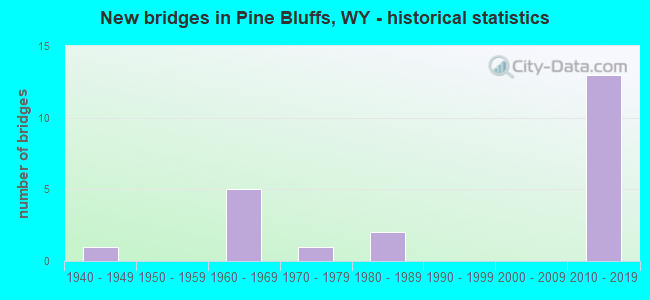
- New bridges - historical statistics
- 11940-1949
- 51960-1969
- 11970-1979
- 21980-1989
- 132010-2019


- Bridge Condition - Deck
- 8.3%Very good
- 58.3%Good
- 25.0%Satisfactory
- 8.3%Poor

- Bridge Condition - Superstructure
- 58.3%Very good
- 8.3%Good
- 33.3%Satisfactory

- Bridge Condition - Substructure
- 50.0%Very good
- 16.7%Good
- 25.0%Satisfactory
- 8.3%Fair

- Bridge Condition - Channel
- 66.7%Very good
- 33.3%Good

- Bridge Condition - Culverts
- 50.0%Very good
- 50.0%Satisfactory
Find on map >> Show street view
Structure Number: AZQ, Location: Cheyenne - Pine Bluffs (Lat: 41.158439, Lng: -104.560528), Route carried "on" structure: Interstate 80, Year Built: 1964, Status: Open, Structure Length: 2.56m (8.40ft), Average Daily Traffic: 5,790 (year 2021), Truck Traffic: 44%, Average Future Daily Traffic: 8,106 (year 2041), Design Load: HS 20+Mod, Features Intersected: Service Road
Minimum Vertical Clearance: 30+ m (98+ ft), Kilometerpoint: 603.556, Lanes on structure: 2, Lanes under structure: 2, Base Highway Network: Yes (Inventory Route: ML8, Subroute: 4), Owner: State Highway Agency, Approaching Roadway Width: 11.6m (38.1ft), Skew: 10 degrees, Material/Design: Concrete continuous, Design/Construction: Slab, Number Of Spans In Main Unit: 3, Length of Maximum Span: 10.7m (35.1ft), Curb-To-Curb Width: 11.6m (38.1ft), Out-to-Out Width: 12.5m (41.0ft)
Condition: Deck: Satisfactory, Superstructure: Satisfactory, Substructure: Satisfactory, Operating Rating: 56.2 metric tons, Method Used To Determine Operating Rating: Load Factor (LF), Inventory Rating: 33.7 metric tons, Method Used To Determine Inventory Rating: Load Factor (LF), Structural Evaluation: Equal to present minimum criteria, Deck Geometry: Equal to present minimum criteria, Underclear: High priority of corrective action, Approach Roadway Alignment: Equal to present desirable criteria, Designated Inspection Frequency: Every 24 months, Inspection Date: January 2022, Deck Structure Type: Concrete Cast-file-Place, Wearing Surface/Protective System: Wearing Surface: Latex Concrete
Find on map >> Show street view
Structure Number: BAH, Location: Cheyenne - Pine Bluffs (Lat: 41.167403, Lng: -104.087544), Route carried "on" structure: Interstate 80, Year Built: 1967, Status: Open, Structure Length: 2.80m (9.19ft), Average Daily Traffic: 5,278 (year 2021), Truck Traffic: 46%, Average Future Daily Traffic: 7,389 (year 2041), Design Load: HS 20+Mod, Features Intersected: I-80 Service Road
Minimum Vertical Clearance: 30+ m (98+ ft), Kilometerpoint: 644.373, Lanes on structure: 2, Lanes under structure: 2, Base Highway Network: Yes (Inventory Route: ML8, Subroute: 4), Owner: State Highway Agency, Approaching Roadway Width: 11.6m (38.1ft), Skew: 10 degrees, Material/Design: Concrete continuous, Design/Construction: Tee Beam, Number Of Spans In Main Unit: 3, Length of Maximum Span: 11.3m (37.1ft), Curb-To-Curb Width: 11.6m (38.1ft), Out-to-Out Width: 12.5m (41.0ft)
Condition: Deck: Poor, Superstructure: Satisfactory, Substructure: Satisfactory, Operating Rating: 50.6 metric tons, Method Used To Determine Operating Rating: Load Factor (LF), Inventory Rating: 30.4 metric tons, Method Used To Determine Inventory Rating: Load Factor (LF), Structural Evaluation: Equal to present minimum criteria, Deck Geometry: Equal to present minimum criteria, Underclear: Meets minimum limits, Approach Roadway Alignment: Equal to present desirable criteria, Length Of Structure Improvement: 0.30m (0.98ft), Designated Inspection Frequency: Every 24 months, Inspection Date: January 2022, Bridge Improvement Cost: $1,000, Roadway Improvement Cost: $1,000, Total Project Cost: $3,000 ( Estimate for 2014), Deck Structure Type: Concrete Cast-file-Place, Wearing Surface/Protective System: Wearing Surface: Latex Concrete
Find on map >> Show street view
Structure Number: BAI, Location: Cheyenne - Pine Bluffs (Lat: 41.167600, Lng: -104.087800), Route carried "on" structure: Interstate 80, Year Built: 1967, Status: Open, Structure Length: 2.80m (9.19ft), Average Daily Traffic: 5,362 (year 2021), Truck Traffic: 44%, Average Future Daily Traffic: 7,507 (year 2041), Design Load: HS 20+Mod, Features Intersected: I-80 Service Road
Minimum Vertical Clearance: 30+ m (98+ ft), Kilometerpoint: 644.074, Lanes on structure: 2, Lanes under structure: 2, Base Highway Network: Yes (Inventory Route: ML8, Subroute: 4), Owner: State Highway Agency, Approaching Roadway Width: 11.6m (38.1ft), Skew: 10 degrees, Material/Design: Concrete continuous, Design/Construction: Tee Beam, Number Of Spans In Main Unit: 3, Length of Maximum Span: 11.3m (37.1ft), Curb-To-Curb Width: 11.6m (38.1ft), Out-to-Out Width: 12.4m (40.7ft)
Condition: Deck: Satisfactory, Superstructure: Satisfactory, Substructure: Satisfactory, Operating Rating: 50.6 metric tons, Method Used To Determine Operating Rating: Load Factor (LF), Inventory Rating: 30.4 metric tons, Method Used To Determine Inventory Rating: Load Factor (LF), Structural Evaluation: Equal to present minimum criteria, Deck Geometry: Equal to present minimum criteria, Underclear: Meets minimum limits, Approach Roadway Alignment: Equal to present desirable criteria, Designated Inspection Frequency: Every 24 months, Inspection Date: January 2022, Deck Structure Type: Concrete Cast-file-Place, Wearing Surface/Protective System: Wearing Surface: Latex Concrete
Find on map >> Show street view
Structure Number: BAL, Location: Cheyenne - Pine Bluffs (Lat: 41.176006, Lng: -104.080603), Route carried "on" structure: ServiceOther road 921, Year Built: 1974, Status: Posted for load, Structure Length: 2.56m (8.40ft), Average Daily Traffic: 2,038 (year 2021), Truck Traffic: 5%, Average Future Daily Traffic: 2,853 (year 2041), Design Load: HS 20, Features Intersected: Muddy Creek, Facility Carried by Structure: I-80 Service Road
Minimum Vertical Clearance: 30+ m (98+ ft), Kilometerpoint: 0.618, Lanes on structure: 2, Owner: County Highway Agency, Approaching Roadway Width: 7.3m (24.0ft), Skew: 10 degrees, Material/Design: Prestressed concrete, Design/Construction: Tee Beam, Number Of Spans In Main Unit: 2, Length of Maximum Span: 12.2m (40.0ft), Curb-To-Curb Width: 8.1m (26.6ft), Out-to-Out Width: 8.5m (27.9ft)
Condition: Deck: Good, Superstructure: Satisfactory, Substructure: Fair, Channel: Good, Operating Rating: 46.7 metric tons, Method Used To Determine Operating Rating: Field evaluation and documented engineering judgment, Inventory Rating: 27.8 metric tons, Method Used To Determine Inventory Rating: Field evaluation and documented engineering judgment, Structural Evaluation: Somewhat better than minimum adequacy, Deck Geometry: High priority of corrective action, Waterway Adequacy: Equal to present desirable criteria, Approach Roadway Alignment: Equal to present desirable criteria, Length Of Structure Improvement: 9.69m (31.79ft), Designated Inspection Frequency: Every 12 months, Inspection Date: December 2021, Bridge Improvement Cost: $17,000, Roadway Improvement Cost: $30,000, Total Project Cost: $49,000, Deck Structure Type: Concrete Precast Panels, Wearing Surface/Protective System: Wearing Surface: Bituminous
Find on map >> Show street view
Structure Number: CRP, Location: Pine Bluffs - Albin (Lat: 41.365108, Lng: -104.080500), Route carried "on" structure: State highway 215, Year Built: 1947, Status: Open, Structure Length: 1.30m (4.27ft), Average Daily Traffic: 624 (year 2021), Truck Traffic: 13%, Average Future Daily Traffic: 874 (year 2041), Design Load: H 15, Features Intersected: Unnamed Draw
Minimum Vertical Clearance: 30+ m (98+ ft), Kilometerpoint: 21.239, Lanes on structure: 2, Owner: State Highway Agency, Approaching Roadway Width: 7.9m (25.9ft), Material/Design: Concrete continuous, Design/Construction: Culvert, Number Of Spans In Main Unit: 4, Length of Maximum Span: 3.0m (9.8ft)
Condition: Channel: Very good, Culverts: Satisfactory, Operating Rating: 32.7 metric tons, Method Used To Determine Operating Rating: Field evaluation and documented engineering judgment, Inventory Rating: 32.7 metric tons, Method Used To Determine Inventory Rating: Field evaluation and documented engineering judgment, Structural Evaluation: Equal to present minimum criteria, Waterway Adequacy: Equal to present desirable criteria, Approach Roadway Alignment: Equal to present desirable criteria, Length Of Structure Improvement: 2.01m (6.59ft), Designated Inspection Frequency: Every 24 months, Inspection Date: April 2021
Find on map >> Show street view
Structure Number: FBF, Location: Pine Bluffs - Albin (Lat: 41.177178, Lng: -104.079108), Route carried "on" structure: State highway 215, Year Built: 1986, Status: Open, Structure Length: 14.97m (49.11ft), Average Daily Traffic: 713 (year 2021), Truck Traffic: 10%, Average Future Daily Traffic: 998 (year 2041), Design Load: HS 20, Features Intersected: UPRR / US 30
Minimum Vertical Clearance: 30+ m (98+ ft), Kilometerpoint: 0.288, Lanes on structure: 2, Lanes under structure: 2, Owner: State Highway Agency, Approaching Roadway Width: 12.2m (40.0ft), Material/Design: Steel continuous, Design/Construction: Stringer/Multi-beam, Number Of Spans In Main Unit: 2, Number Of Approach Spans: 2, Length of Maximum Span: 58.5m (191.9ft), Curb or Sidewalk Widths: Left: 0.0m, Right: 1.5m (4.9ft), Curb-To-Curb Width: 12.2m (40.0ft), Out-to-Out Width: 14.9m (48.9ft)
Condition: Deck: Satisfactory, Superstructure: Good, Substructure: Good, Operating Rating: 55.3 metric tons, Method Used To Determine Operating Rating: Load Factor (LF), Inventory Rating: 32.7 metric tons, Method Used To Determine Inventory Rating: Load Factor (LF), Structural Evaluation: Better than present minimum criteria, Deck Geometry: Equal to present desirable criteria, Underclear: Superior to present desirable criteria, Approach Roadway Alignment: Equal to present minimum criteria, Designated Inspection Frequency: Every 24 months, Inspection Date: April 2021, Deck Structure Type: Concrete Cast-file-Place, Wearing Surface/Protective System: Deck Protection: Epoxy Coated Reinforcing
Find on map >> Show street view
Structure Number: MUP, Location: Pine Bluffs (Lat: 41.174064, Lng: -104.081225), Route carried "on" structure: Interstate 80, Year Built: 2017, Status: Open, Structure Length: 6.40m (21.00ft), Average Daily Traffic: 5,278 (year 2021), Truck Traffic: 46%, Average Future Daily Traffic: 7,389 (year 2041), Design Load: HL 93, Features Intersected: Muddy Creek
Minimum Vertical Clearance: 30+ m (98+ ft), Kilometerpoint: 645.284, Lanes on structure: 2, Base Highway Network: Yes, Owner: State Highway Agency, Approaching Roadway Width: 13.1m (43.0ft), Skew: 3 degrees, Material/Design: Steel continuous, Design/Construction: Stringer/Multi-beam, Number Of Spans In Main Unit: 4, Length of Maximum Span: 19.1m (62.7ft), Curb-To-Curb Width: 12.2m (40.0ft), Out-to-Out Width: 13.2m (43.3ft)
Condition: Deck: Good, Superstructure: Very good, Substructure: Good, Channel: Good, Operating Rating: 42.1 metric tons, Method Used To Determine Operating Rating: Assigned ratings based on Load and Resistance Factor Design (LRFD) reported by rating factor (RF) using HL93 loadings, Inventory Rating: 32.4 metric tons, Method Used To Determine Inventory Rating: Assigned ratings based on Load and Resistance Factor Design (LRFD) reported by rating factor (RF) using HL93 loadings, Structural Evaluation: Better than present minimum criteria, Deck Geometry: Better than present minimum criteria, Waterway Adequacy: Better than present minimum criteria, Approach Roadway Alignment: Equal to present desirable criteria, Designated Inspection Frequency: Every 24 months, Inspection Date: November 2021, Deck Structure Type: Concrete Cast-file-Place, Wearing Surface/Protective System: Wearing Surface: Epoxy Overlay, Deck Protection: Epoxy Coated Reinforcing
Find on map >> Show street view
Structure Number: MUQ, Location: Cheyenne - Pine Bluffs (Lat: 41.174303, Lng: -104.081300), Route carried "on" structure: Interstate 80, Year Built: 2015, Status: Open, Structure Length: 7.62m (25.00ft), Average Daily Traffic: 4,449 (year 2021), Truck Traffic: 44%, Average Future Daily Traffic: 6,229 (year 2041), Design Load: HL 93, Features Intersected: Muddy Creek
Minimum Vertical Clearance: 30+ m (98+ ft), Kilometerpoint: 644.999, Lanes on structure: 2, Lanes under structure: 2, Base Highway Network: Yes (Inventory Route: ML8, Subroute: 4), Owner: State Highway Agency, Approaching Roadway Width: 15.2m (49.9ft), Skew: 3 degrees, Material/Design: Steel continuous, Design/Construction: Stringer/Multi-beam, Number Of Spans In Main Unit: 4, Length of Maximum Span: 19.1m (62.7ft), Curb-To-Curb Width: 15.2m (49.9ft), Out-to-Out Width: 16.3m (53.5ft)
Condition: Deck: Good, Superstructure: Very good, Substructure: Very good, Channel: Very good, Operating Rating: 50.5 metric tons, Method Used To Determine Operating Rating: Load and Resistance Factor Rating (LRFR) rating reported by rating factor(RF) method using HL-93 loadings, Inventory Rating: 38.9 metric tons, Method Used To Determine Inventory Rating: Load and Resistance Factor Rating (LRFR) rating reported by rating factor(RF) method using HL-93 loadings, Structural Evaluation: Equal to present desirable criteria, Deck Geometry: Superior to present desirable criteria, Underclear: High priority of corrective action, Waterway Adequacy: Equal to present desirable criteria, Approach Roadway Alignment: Equal to present desirable criteria, Designated Inspection Frequency: Every 24 months, Inspection Date: November 2021, Deck Structure Type: Concrete Cast-file-Place, Wearing Surface/Protective System: Wearing Surface: Epoxy Overlay, Deck Protection: Epoxy Coated Reinforcing
Find on map >> Show street view
Structure Number: MUR, Location: Pine Bluffs (Lat: 41.175692, Lng: -104.076019), Route carried "on" structure: Interstate 80, Year Built: 2017, Status: Open, Structure Length: 4.88m (16.01ft), Average Daily Traffic: 5,278 (year 2021), Truck Traffic: 46%, Average Future Daily Traffic: 7,389 (year 2041), Design Load: HL 93, Features Intersected: Parsons Street
Minimum Vertical Clearance: 30+ m (98+ ft), Kilometerpoint: 645.764, Lanes on structure: 2, Lanes under structure: 2, Base Highway Network: Yes (Inventory Route: ML8, Subroute: 4), Owner: State Highway Agency, Approaching Roadway Width: 12.2m (40.0ft), Material/Design: Steel, Design/Construction: Stringer/Multi-beam, Number Of Spans In Main Unit: 3, Length of Maximum Span: 24.4m (80.1ft), Curb-To-Curb Width: 12.2m (40.0ft), Out-to-Out Width: 13.2m (43.3ft)
Condition: Deck: Very good, Superstructure: Very good, Substructure: Very good, Operating Rating: 84.9 metric tons, Method Used To Determine Operating Rating: Load and Resistance Factor Rating (LRFR) rating reported by rating factor(RF) method using HL-93 loadings, Inventory Rating: 65.4 metric tons, Method Used To Determine Inventory Rating: Load and Resistance Factor Rating (LRFR) rating reported by rating factor(RF) method using HL-93 loadings, Structural Evaluation: Equal to present desirable criteria, Deck Geometry: Better than present minimum criteria, Underclear: Equal to present minimum criteria, Approach Roadway Alignment: Equal to present desirable criteria, Designated Inspection Frequency: Every 24 months, Inspection Date: November 2021, Deck Structure Type: Concrete Cast-file-Place, Wearing Surface/Protective System: Wearing Surface: Epoxy Overlay, Deck Protection: Epoxy Coated Reinforcing
Find on map >> Show street view
Structure Number: MUS, Location: Pine Bluffs (Lat: 41.175894, Lng: -104.076092), Route carried "on" structure: Interstate 80, Year Built: 2015, Status: Open, Structure Length: 5.49m (18.01ft), Average Daily Traffic: 4,449 (year 2021), Truck Traffic: 44%, Average Future Daily Traffic: 6,229 (year 2041), Design Load: HL 93, Features Intersected: Parsons Street
Minimum Vertical Clearance: 30+ m (98+ ft), Kilometerpoint: 645.482, Lanes on structure: 2, Lanes under structure: 2, Base Highway Network: Yes (Inventory Route: ML8, Subroute: 4), Owner: State Highway Agency, Approaching Roadway Width: 12.2m (40.0ft), Material/Design: Steel continuous, Design/Construction: Stringer/Multi-beam, Number Of Spans In Main Unit: 3, Length of Maximum Span: 24.4m (80.1ft), Curb-To-Curb Width: 12.2m (40.0ft), Out-to-Out Width: 13.2m (43.3ft)
Condition: Deck: Good, Superstructure: Very good, Substructure: Very good, Operating Rating: 65.8 metric tons, Method Used To Determine Operating Rating: Load and Resistance Factor Rating (LRFR) rating reported by rating factor(RF) method using HL-93 loadings, Inventory Rating: 50.9 metric tons, Method Used To Determine Inventory Rating: Load and Resistance Factor Rating (LRFR) rating reported by rating factor(RF) method using HL-93 loadings, Structural Evaluation: Equal to present desirable criteria, Deck Geometry: Better than present minimum criteria, Underclear: Equal to present minimum criteria, Approach Roadway Alignment: Equal to present desirable criteria, Designated Inspection Frequency: Every 24 months, Inspection Date: November 2021, Deck Structure Type: Concrete Cast-file-Place, Wearing Surface/Protective System: Wearing Surface: Epoxy Overlay, Deck Protection: Epoxy Coated Reinforcing
Find on map >> Show street view
Structure Number: MUT, Location: Pine Bluffs (Lat: 41.174947, Lng: -104.063061), Route carried "on" structure: Interstate 80, Year Built: 2016, Status: Open, Structure Length: 4.88m (16.01ft), Average Daily Traffic: 4,535 (year 2021), Truck Traffic: 56%, Average Future Daily Traffic: 6,349 (year 2041), Design Load: HL 93, Features Intersected: Beech Street
Minimum Vertical Clearance: 30+ m (98+ ft), Kilometerpoint: 646.861, Lanes on structure: 2, Lanes under structure: 2, Base Highway Network: Yes, Owner: State Highway Agency, Approaching Roadway Width: 13.2m (43.3ft), Skew: 1 degrees, Material/Design: Steel, Design/Construction: Stringer/Multi-beam, Number Of Spans In Main Unit: 3, Length of Maximum Span: 24.4m (80.1ft), Curb-To-Curb Width: 12.2m (40.0ft), Out-to-Out Width: 13.2m (43.3ft)
Condition: Deck: Good, Superstructure: Very good, Substructure: Very good, Operating Rating: 80.0 metric tons, Method Used To Determine Operating Rating: Load and Resistance Factor Rating (LRFR) rating reported by rating factor(RF) method using HL-93 loadings, Inventory Rating: 61.6 metric tons, Method Used To Determine Inventory Rating: Load and Resistance Factor Rating (LRFR) rating reported by rating factor(RF) method using HL-93 loadings, Structural Evaluation: Equal to present desirable criteria, Deck Geometry: Better than present minimum criteria, Underclear: Somewhat better than minimum adequacy, Approach Roadway Alignment: Equal to present desirable criteria, Designated Inspection Frequency: Every 24 months, Inspection Date: November 2021, Deck Structure Type: Concrete Cast-file-Place, Wearing Surface/Protective System: Wearing Surface: Epoxy Overlay, Deck Protection: Epoxy Coated Reinforcing
Find on map >> Show street view
Structure Number: MUV, Location: Pine Bluffs (Lat: 41.175100, Lng: -104.063017), Route carried "on" structure: Interstate 80, Year Built: 2015, Status: Open, Structure Length: 4.57m (14.99ft), Average Daily Traffic: 4,449 (year 2021), Truck Traffic: 44%, Average Future Daily Traffic: 6,229 (year 2041), Design Load: HL 93, Features Intersected: Beech Street
Minimum Vertical Clearance: 30+ m (98+ ft), Kilometerpoint: 646.589, Lanes on structure: 2, Lanes under structure: 2, Base Highway Network: Yes (Inventory Route: ML8, Subroute: 4), Owner: State Highway Agency, Approaching Roadway Width: 12.2m (40.0ft), Skew: 1 degrees, Material/Design: Steel continuous, Design/Construction: Stringer/Multi-beam, Number Of Spans In Main Unit: 3, Length of Maximum Span: 24.4m (80.1ft), Curb-To-Curb Width: 12.2m (40.0ft), Out-to-Out Width: 13.2m (43.3ft)
Condition: Deck: Good, Superstructure: Very good, Substructure: Very good, Operating Rating: 64.2 metric tons, Method Used To Determine Operating Rating: Load and Resistance Factor Rating (LRFR) rating reported by rating factor(RF) method using HL-93 loadings, Inventory Rating: 49.6 metric tons, Method Used To Determine Inventory Rating: Load and Resistance Factor Rating (LRFR) rating reported by rating factor(RF) method using HL-93 loadings, Structural Evaluation: Equal to present desirable criteria, Deck Geometry: Better than present minimum criteria, Underclear: Equal to present minimum criteria, Approach Roadway Alignment: Equal to present desirable criteria, Designated Inspection Frequency: Every 24 months, Inspection Date: November 2021, Deck Structure Type: Concrete Cast-file-Place, Wearing Surface/Protective System: Wearing Surface: Epoxy Overlay, Deck Protection: Epoxy Coated Reinforcing
Find on map >> Show street view
Structure Number: NDA, Location: North of Pine Bluffs (Lat: 41.187408, Lng: -104.081761), Route carried "on" structure: State highway 215, Year Built: 2019, Status: Open, Structure Length: 3.35m (10.99ft), Average Daily Traffic: 713 (year 2021), Truck Traffic: 10%, Average Future Daily Traffic: 998 (year 2041), Design Load: HL 93, Features Intersected: Lodgepole Creek
Minimum Vertical Clearance: 30+ m (98+ ft), Kilometerpoint: 1.510, Lanes on structure: 2, Owner: State Highway Agency, Approaching Roadway Width: 9.1m (29.9ft), Material/Design: Steel continuous, Design/Construction: Stringer/Multi-beam, Number Of Spans In Main Unit: 2, Length of Maximum Span: 16.4m (53.8ft), Curb-To-Curb Width: 9.1m (29.9ft), Out-to-Out Width: 10.2m (33.5ft)
Condition: Deck: Good, Superstructure: Very good, Substructure: Very good, Channel: Very good, Operating Rating: 56.1 metric tons, Method Used To Determine Operating Rating: Load and Resistance Factor Rating (LRFR) rating reported by rating factor(RF) method using HL-93 loadings, Inventory Rating: 43.1 metric tons, Method Used To Determine Inventory Rating: Load and Resistance Factor Rating (LRFR) rating reported by rating factor(RF) method using HL-93 loadings, Structural Evaluation: Equal to present desirable criteria, Deck Geometry: Equal to present minimum criteria, Waterway Adequacy: Equal to present desirable criteria, Approach Roadway Alignment: Equal to present desirable criteria, Designated Inspection Frequency: Every 24 months, Inspection Date: August 2020, Deck Structure Type: Concrete Cast-file-Place, Wearing Surface/Protective System: Deck Protection: Epoxy Coated Reinforcing
Find on map >> Show street view
Structure Number: NDB, Location: North of Pine Bluffs (Lat: 41.198639, Lng: -104.081575), Route carried "on" structure: State highway 215, Year Built: 2019, Status: Open, Structure Length: 0.75m (2.46ft), Average Daily Traffic: 624 (year 2021), Truck Traffic: 13%, Average Future Daily Traffic: 874 (year 2041), Design Load: HL 93, Features Intersected: Spring Creek
Minimum Vertical Clearance: 30+ m (98+ ft), Kilometerpoint: 2.757, Lanes on structure: 2, Owner: State Highway Agency, Approaching Roadway Width: 9.2m (30.2ft), Material/Design: Concrete, Design/Construction: Culvert, Number Of Spans In Main Unit: 2, Length of Maximum Span: 3.7m (12.1ft)
Condition: Channel: Very good, Culverts: Very good, Operating Rating: 46.7 metric tons, Method Used To Determine Operating Rating: Load and Resistance Factor Rating (LRFR) rating reported by rating factor(RF) method using HL-93 loadings, Inventory Rating: 36.0 metric tons, Method Used To Determine Inventory Rating: Load and Resistance Factor Rating (LRFR) rating reported by rating factor(RF) method using HL-93 loadings, Structural Evaluation: Equal to present desirable criteria, Waterway Adequacy: Equal to present desirable criteria, Approach Roadway Alignment: Equal to present desirable criteria, Designated Inspection Frequency: Every 24 months, Inspection Date: August 2020
Find on map >> Show street view
Structure Number: BAH, Location: Cheyenne - Pine Bluffs (Lat: 41.167403, Lng: -104.087544), Route carried "under" structure: ServiceOther road 921, Year Built: 1967, Structure Length: 0. m, Average Daily Traffic: 2,038 (year 2021), Truck Traffic: 5%, Features Intersected: I-80 Service Road, Facility Carried by Structure: I-80 EBL
Minimum Vertical Clearance: 4.54m (14.90ft), Kilometerpoint: 1.790, Lanes on structure: 2, Lanes under structure: 2, Material/Design: Concrete continuous, Design/Construction: Tee Beam, Length of Maximum Span: 11.3m (37.1ft)
Find on map >> Show street view
Structure Number: BAI, Location: Cheyenne - Pine Bluffs (Lat: 41.167600, Lng: -104.087800), Route carried "under" structure: ServiceOther road 921, Year Built: 1967, Structure Length: 0. m, Average Daily Traffic: 2,038 (year 2021), Truck Traffic: 5%, Features Intersected: I-80 Service Road, Facility Carried by Structure: I-80 WBL
Minimum Vertical Clearance: 4.42m (14.50ft), Kilometerpoint: 1.761, Lanes on structure: 2, Lanes under structure: 2, Material/Design: Concrete continuous, Design/Construction: Tee Beam, Length of Maximum Span: 11.3m (37.1ft)
Find on map >> Show street view
Structure Number: FBF, Location: Pine Bluffs - Albin (Lat: 41.177178, Lng: -104.079108), Route carried "under" structure: ServiceOther road 921, Year Built: 1986, Structure Length: 0. m, Average Daily Traffic: 2,038 (year 2021), Truck Traffic: 5%, Features Intersected: UPRR / US 30, Facility Carried by Structure: WYO 215
Minimum Vertical Clearance: 9.92m (32.55ft), Kilometerpoint: 0.438, Lanes on structure: 2, Lanes under structure: 2, Material/Design: Steel continuous, Design/Construction: Stringer/Multi-beam, Length of Maximum Span: 58.5m (191.9ft)
Find on map >> Show street view
Structure Number: MUQ, Location: Cheyenne - Pine Bluffs (Lat: 41.174303, Lng: -104.081300), Route carried "under" structure: City street , Year Built: 2015, Structure Length: 0. m, Average Daily Traffic: 250 (year 2021), Truck Traffic: 5%, Features Intersected: Muddy Creek, Facility Carried by Structure: I-80 WBL
Minimum Vertical Clearance: 6.38m (20.93ft), Kilometerpoint: 0.253, Lanes on structure: 2, Lanes under structure: 2, Material/Design: Steel continuous, Design/Construction: Stringer/Multi-beam, Length of Maximum Span: 19.1m (62.7ft)
Find on map >> Show street view
Structure Number: MUR, Location: Pine Bluffs (Lat: 41.175692, Lng: -104.076019), Route carried "under" structure: City street 30, Year Built: 2017, Structure Length: 0. m, Average Daily Traffic: 2,201 (year 2021), Truck Traffic: 10%, Features Intersected: Parsons Street, Facility Carried by Structure: I-80 EBL
Minimum Vertical Clearance: 5.14m (16.86ft), Kilometerpoint: 0.011, Lanes on structure: 2, Lanes under structure: 2, Material/Design: Steel, Design/Construction: Stringer/Multi-beam, Length of Maximum Span: 24.4m (80.1ft)
Find on map >> Show street view
Structure Number: MUS, Location: Pine Bluffs (Lat: 41.175894, Lng: -104.076092), Route carried "under" structure: US 30, Year Built: 2015, Structure Length: 0. m, Average Daily Traffic: 2,201 (year 2021), Truck Traffic: 10%, Features Intersected: Parsons Street, Facility Carried by Structure: I-80 WBL
Minimum Vertical Clearance: 6.63m (21.75ft), Kilometerpoint: 646.099, Lanes on structure: 2, Lanes under structure: 2, Material/Design: Steel continuous, Design/Construction: Stringer/Multi-beam, Length of Maximum Span: 24.4m (80.1ft)
Find on map >> Show street view
Structure Number: MUT, Location: Pine Bluffs (Lat: 41.174947, Lng: -104.063061), Route carried "under" structure: County highway 164-1, Year Built: 2016, Structure Length: 0. m, Average Daily Traffic: 250 (year 2021), Truck Traffic: 5%, Features Intersected: Beech Street, Facility Carried by Structure: I-80 EBL
Minimum Vertical Clearance: 5.94m (19.49ft), Kilometerpoint: 19.405, Lanes on structure: 2, Lanes under structure: 2, Material/Design: Steel, Design/Construction: Stringer/Multi-beam, Length of Maximum Span: 24.4m (80.1ft)
Find on map >> Show street view
Structure Number: MUV, Location: Pine Bluffs (Lat: 41.175100, Lng: -104.063017), Route carried "under" structure: County highway 164-1, Year Built: 2015, Structure Length: 0. m, Average Daily Traffic: 250 (year 2021), Truck Traffic: 5%, Features Intersected: Beech Street, Facility Carried by Structure: I-80 WBL
Minimum Vertical Clearance: 5.11m (16.77ft), Kilometerpoint: 19.422, Lanes on structure: 2, Lanes under structure: 2, Material/Design: Steel continuous, Design/Construction: Stringer/Multi-beam, Length of Maximum Span: 24.4m (80.1ft)