Bridge Statistics for Pleasant Valley, Missouri (MO)
Condition, Traffic, Stress, Structural Evaluation, Project Costs
- National Bridge Inventory (NBI) Statistics
- 47Number of bridges
- 509ft / 155mTotal length
- 793,015Total average daily traffic
- 125,887Total average daily truck traffic
- National Bridge Inventory (NBI) Registered Bridges for Pleasant Valley
- No street view available for this location
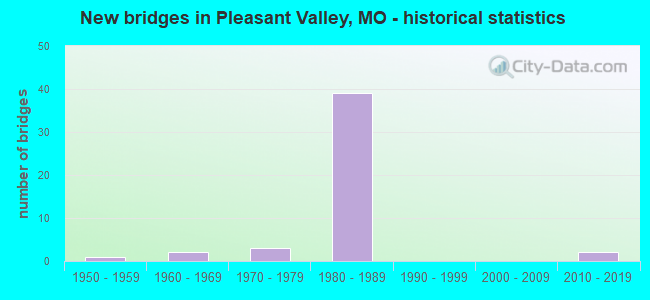
- New bridges - historical statistics
- 11950-1959
- 21960-1969
- 31970-1979
- 391980-1989
- 22010-2019


- Bridge Condition - Deck
- 40.0%Good
- 55.0%Satisfactory
- 5.0%Fair

- Bridge Condition - Superstructure
- 5.0%Excellent
- 50.0%Good
- 45.0%Satisfactory

- Bridge Condition - Substructure
- 5.0%Excellent
- 5.0%Very good
- 40.0%Good
- 40.0%Satisfactory
- 10.0%Fair

- Bridge Condition - Channel
- 57.1%Good
- 42.9%Satisfactory
Find on map >> Show street view
Structure Number: 1274, Location: S 27 T 51 N R 32 W (Lat: 39.202472, Lng: -94.492853), Route carried "on" structure: Ramp State highway , Year Built: 1969, Status: Open, Structure Length: 6.13m (20.11ft), Average Daily Traffic: 1,718 (year 2021), Truck Traffic: 13%, Average Future Daily Traffic: 3,092 (year 2041), Design Load: HS 20, Features Intersected: US 69, Facility Carried by Structure: RP IS35N TO IS435S
Minimum Vertical Clearance: 30+ m (98+ ft), Kilometerpoint: 0.523, Lanes on structure: 2, Lanes under structure: 5, Base Highway Network: Yes, Owner: State Highway Agency, Approaching Roadway Width: 11.6m (38.1ft), Skew: 2 degrees, Material/Design: Concrete continuous, Design/Construction: Slab, Number Of Spans In Main Unit: 4, Length of Maximum Span: 18.3m (60.0ft), Curb-To-Curb Width: 11.6m (38.1ft), Out-to-Out Width: 12.4m (40.7ft)
Condition: Deck: Satisfactory, Superstructure: Satisfactory, Substructure: Good, Operating Rating: 65.7 metric tons, Method Used To Determine Operating Rating: Load Factor (LF), Inventory Rating: 39.6 metric tons, Method Used To Determine Inventory Rating: Load Factor (LF), Structural Evaluation: Equal to present minimum criteria, Deck Geometry: Superior to present desirable criteria, Underclear: Equal to present minimum criteria, Approach Roadway Alignment: Equal to present desirable criteria, Designated Inspection Frequency: Every 24 months, Inspection Date: September 2020, Deck Structure Type: Concrete Cast-file-Place, Wearing Surface/Protective System: Wearing Surface: Low Slump Concrete, Membrane: Built-up, Deck Protection: Internally Sealed
Find on map >> Show street view
Structure Number: 1276, Location: S 27 T 51 N R 32 W (Lat: 39.200008, Lng: -94.492717), Route carried "on" structure: Interstate 435, Year Built: 1969, Status: Open, Structure Length: 1.35m (4.43ft), Average Daily Traffic: 59,966 (year 2021), Truck Traffic: 15%, Average Future Daily Traffic: 107,939 (year 2041), Design Load: HS 20, Features Intersected: MILL CR
Minimum Vertical Clearance: 30+ m (98+ ft), Kilometerpoint: 51.827, Lanes on structure: 6, Base Highway Network: Yes, Owner: State Highway Agency, Approaching Roadway Width: 17.1m (56.1ft), Skew: 20 degrees, Material/Design: Concrete continuous, Design/Construction: Culvert, Number Of Spans In Main Unit: 3, Length of Maximum Span: 4.3m (14.1ft)
Condition: Channel: Good, Culverts: Satisfactory, Operating Rating: 87.3 metric tons, Method Used To Determine Operating Rating: Field evaluation and documented engineering judgment, Inventory Rating: 52.2 metric tons, Method Used To Determine Inventory Rating: Field evaluation and documented engineering judgment, Structural Evaluation: Equal to present minimum criteria, Waterway Adequacy: Equal to present minimum criteria, Approach Roadway Alignment: Equal to present desirable criteria, Designated Inspection Frequency: Every 24 months, Inspection Date: November 2020
Find on map >> Show street view
Structure Number: 2774, Location: S 18 T 52 N R 32 W (Lat: 39.311192, Lng: -94.533844), Route carried "on" structure: Interstate 435, Year Built: 1983, Status: Open, Structure Length: 3.93m (12.89ft), Average Daily Traffic: 9,943 (year 2021), Truck Traffic: 19%, Average Future Daily Traffic: 17,897 (year 2041), Design Load: HS 20+Mod, Features Intersected: CST N MERSINGTON AVE
Minimum Vertical Clearance: 30+ m (98+ ft), Kilometerpoint: 51.443, Lanes on structure: 2, Lanes under structure: 2, Base Highway Network: Yes, Owner: State Highway Agency, Approaching Roadway Width: 12.2m (40.0ft), Material/Design: Prestressed concrete continuous, Design/Construction: Stringer/Multi-beam, Number Of Spans In Main Unit: 3, Length of Maximum Span: 20.4m (66.9ft), Curb or Sidewalk Widths: Left: 0.2m (0.7ft), Right: 0.2m (0.7ft), Curb-To-Curb Width: 11.8m (38.7ft), Out-to-Out Width: 13.0m (42.7ft)
Condition: Deck: Good, Superstructure: Good, Substructure: Good, Operating Rating: 49.5 metric tons, Method Used To Determine Operating Rating: Load Factor (LF), Inventory Rating: 29.7 metric tons, Method Used To Determine Inventory Rating: Load Factor (LF), Structural Evaluation: Better than present minimum criteria, Deck Geometry: Equal to present minimum criteria, Approach Roadway Alignment: Equal to present desirable criteria, Designated Inspection Frequency: Every 24 months, Inspection Date: September 2020, Deck Structure Type: Concrete Cast-file-Place, Wearing Surface/Protective System: Wearing Surface: Monolithic Concrete, Deck Protection: Epoxy Coated Reinforcing
Find on map >> Show street view
Structure Number: 28, Location: S 13 T 28 N R 15 W (Lat: 37.108708, Lng: -92.526411), Route carried "on" structure: US 60, Year Built: 1957, Year Reconstructed: 1977, Status: Open, Structure Length: 0.68m (2.23ft), Average Daily Traffic: 12,509 (year 2021), Truck Traffic: 23%, Average Future Daily Traffic: 21,891 (year 2041), Design Load: HS 20, Features Intersected: FK SPENCE CR
Minimum Vertical Clearance: 30+ m (98+ ft), Kilometerpoint: 209.411, Lanes on structure: 4, Base Highway Network: Yes, Owner: State Highway Agency, Approaching Roadway Width: 39.0m (128.0ft), Skew: 22 degrees, Material/Design: Concrete continuous, Design/Construction: Culvert, Number Of Spans In Main Unit: 2, Length of Maximum Span: 3.0m (9.8ft)
Condition: Channel: Satisfactory, Culverts: Satisfactory, Operating Rating: 72.0 metric tons, Method Used To Determine Operating Rating: Field evaluation and documented engineering judgment, Inventory Rating: 43.2 metric tons, Method Used To Determine Inventory Rating: Field evaluation and documented engineering judgment, Structural Evaluation: Equal to present minimum criteria, Waterway Adequacy: Equal to present desirable criteria, Approach Roadway Alignment: Equal to present desirable criteria, Designated Inspection Frequency: Every 24 months, Inspection Date: Febuary 2022
Find on map >> Show street view
Structure Number: 28, Location: S 16 T 51 N R 32 W (Lat: 39.231497, Lng: -94.503322), Route carried "on" structure: Interstate 435, Year Built: 1980, Status: Open, Structure Length: 4.91m (16.11ft), Average Daily Traffic: 17,793 (year 2021), Truck Traffic: 15%, Average Future Daily Traffic: 32,027 (year 2041), Design Load: HS 20, Features Intersected: E FK SHOAL CR
Minimum Vertical Clearance: 30+ m (98+ ft), Kilometerpoint: 48.045, Lanes on structure: 3, Base Highway Network: Yes, Owner: State Highway Agency, Approaching Roadway Width: 17.1m (56.1ft), Skew: 14 degrees, Material/Design: Prestressed concrete continuous, Design/Construction: Stringer/Multi-beam, Number Of Spans In Main Unit: 3, Length of Maximum Span: 16.4m (53.8ft), Curb or Sidewalk Widths: Left: 0.2m (0.7ft), Right: 0.2m (0.7ft), Curb-To-Curb Width: 17.1m (56.1ft), Out-to-Out Width: 17.9m (58.7ft)
Condition: Deck: Satisfactory, Superstructure: Satisfactory, Substructure: Good, Channel: Satisfactory, Operating Rating: 80.1 metric tons, Method Used To Determine Operating Rating: Load Factor (LF), Inventory Rating: 37.8 metric tons, Method Used To Determine Inventory Rating: Load Factor (LF), Structural Evaluation: Equal to present minimum criteria, Deck Geometry: Equal to present minimum criteria, Waterway Adequacy: Equal to present desirable criteria, Approach Roadway Alignment: Equal to present desirable criteria, Designated Inspection Frequency: Every 24 months, Inspection Date: September 2020, Deck Structure Type: Concrete Cast-file-Place, Wearing Surface/Protective System: Wearing Surface: Monolithic Concrete, Deck Protection: Epoxy Coated Reinforcing
Find on map >> Show street view
Structure Number: 2801, Location: S 16 T 51 N R 32 W (Lat: 39.231803, Lng: -94.503028), Route carried "on" structure: Interstate 435, Year Built: 1980, Status: Open, Structure Length: 4.91m (16.11ft), Average Daily Traffic: 18,028 (year 2021), Truck Traffic: 19%, Average Future Daily Traffic: 32,450 (year 2041), Design Load: HS 20, Features Intersected: E FK SHOAL CR
Minimum Vertical Clearance: 30+ m (98+ ft), Kilometerpoint: 40.818, Lanes on structure: 3, Base Highway Network: Yes, Owner: State Highway Agency, Approaching Roadway Width: 17.1m (56.1ft), Skew: 14 degrees, Material/Design: Prestressed concrete continuous, Design/Construction: Stringer/Multi-beam, Number Of Spans In Main Unit: 3, Length of Maximum Span: 16.4m (53.8ft), Curb or Sidewalk Widths: Left: 0.2m (0.7ft), Right: 0.2m (0.7ft), Curb-To-Curb Width: 17.1m (56.1ft), Out-to-Out Width: 17.9m (58.7ft)
Condition: Deck: Satisfactory, Superstructure: Satisfactory, Substructure: Good, Channel: Satisfactory, Operating Rating: 80.1 metric tons, Method Used To Determine Operating Rating: Load Factor (LF), Inventory Rating: 37.8 metric tons, Method Used To Determine Inventory Rating: Load Factor (LF), Structural Evaluation: Equal to present minimum criteria, Deck Geometry: Equal to present minimum criteria, Waterway Adequacy: Equal to present desirable criteria, Approach Roadway Alignment: Equal to present desirable criteria, Designated Inspection Frequency: Every 24 months, Inspection Date: September 2020, Deck Structure Type: Concrete Cast-file-Place, Wearing Surface/Protective System: Wearing Surface: Monolithic Concrete, Deck Protection: Other Coated Reinforcing
Find on map >> Show street view
Structure Number: 2808, Location: S 16 T 51 N R 32 W (Lat: 39.224364, Lng: -94.499592), Route carried "on" structure: City street , Year Built: 1980, Status: Open, Structure Length: 9.57m (31.40ft), Average Daily Traffic: 4,696 (year 2021), Truck Traffic: 3%, Average Future Daily Traffic: 7,514 (year 2041), Design Load: HS 20, Features Intersected: IS 435, Facility Carried by Structure: NE SHOAL CREEK PKW
Minimum Vertical Clearance: 30+ m (98+ ft), Kilometerpoint: 4.991, Lanes on structure: 4, Lanes under structure: 6, Owner: State Highway Agency, Approaching Roadway Width: 26.2m (86.0ft), Skew: 22 degrees, Material/Design: Steel continuous, Design/Construction: Stringer/Multi-beam, Number Of Spans In Main Unit: 4, Length of Maximum Span: 35.7m (117.1ft), Curb-To-Curb Width: 26.2m (86.0ft), Out-to-Out Width: 27.2m (89.2ft)
Condition: Deck: Fair, Superstructure: Satisfactory, Substructure: Fair, Operating Rating: 49.5 metric tons, Method Used To Determine Operating Rating: Allowable Stress (AS), Inventory Rating: 36.0 metric tons, Method Used To Determine Inventory Rating: Allowable Stress (AS), Structural Evaluation: Somewhat better than minimum adequacy, Deck Geometry: Superior to present desirable criteria, Underclear: Better than present minimum criteria, Approach Roadway Alignment: Equal to present desirable criteria, Designated Inspection Frequency: Every 24 months, Other Special Inspection Frequency: Every 24 months, Inspection Date: March 2021, Other Special Inspection Date: March 2021, Deck Structure Type: Concrete Cast-file-Place, Wearing Surface/Protective System: Wearing Surface: Monolithic Concrete, Deck Protection: Epoxy Coated Reinforcing
Find on map >> Show street view
Structure Number: 2842, Location: S 27 T 51 N R 32 W (Lat: 39.206364, Lng: -94.491722), Route carried "on" structure: Interstate 435, Year Built: 1981, Status: Open, Structure Length: 10.27m (33.69ft), Average Daily Traffic: 18,887 (year 2021), Truck Traffic: 15%, Average Future Daily Traffic: 33,997 (year 2041), Design Load: HS 20, Features Intersected: IS 35, RP IS35N TO IS435
Minimum Vertical Clearance: 30+ m (98+ ft), Kilometerpoint: 51.053, Lanes on structure: 2, Lanes under structure: 7, Base Highway Network: Yes, Owner: State Highway Agency, Approaching Roadway Width: 13.4m (44.0ft), Skew: 13 degrees, Material/Design: Steel continuous, Design/Construction: Stringer/Multi-beam, Number Of Spans In Main Unit: 4, Length of Maximum Span: 32.6m (107.0ft), Curb-To-Curb Width: 12.2m (40.0ft), Out-to-Out Width: 13.2m (43.3ft)
Condition: Deck: Good, Superstructure: Good, Substructure: Satisfactory, Operating Rating: 58.5 metric tons, Method Used To Determine Operating Rating: Load Factor (LF), Inventory Rating: 35.1 metric tons, Method Used To Determine Inventory Rating: Load Factor (LF), Structural Evaluation: Equal to present minimum criteria, Deck Geometry: Better than present minimum criteria, Underclear: High priority of corrective action, Approach Roadway Alignment: Equal to present desirable criteria, Designated Inspection Frequency: Every 24 months, Inspection Date: September 2020, Deck Structure Type: Concrete Cast-file-Place, Wearing Surface/Protective System: Wearing Surface: Monolithic Concrete, Deck Protection: Epoxy Coated Reinforcing
Find on map >> Show street view
Structure Number: 2843, Location: S 27 T 51 N R 32 W (Lat: 39.206394, Lng: -94.491425), Route carried "on" structure: Interstate 435, Year Built: 1981, Status: Open, Structure Length: 10.94m (35.89ft), Average Daily Traffic: 30,465 (year 2021), Truck Traffic: 19%, Average Future Daily Traffic: 54,837 (year 2041), Design Load: HS 20, Features Intersected: IS 35, RP IS35N TO IS435
Minimum Vertical Clearance: 30+ m (98+ ft), Kilometerpoint: 37.713, Lanes on structure: 3, Lanes under structure: 7, Base Highway Network: Yes, Owner: State Highway Agency, Approaching Roadway Width: 14.6m (47.9ft), Skew: 3 degrees, Material/Design: Steel continuous, Design/Construction: Stringer/Multi-beam, Number Of Spans In Main Unit: 4, Length of Maximum Span: 39.9m (130.9ft), Curb-To-Curb Width: 14.6m (47.9ft), Out-to-Out Width: 15.6m (51.2ft)
Condition: Deck: Good, Superstructure: Good, Substructure: Satisfactory, Operating Rating: 67.5 metric tons, Method Used To Determine Operating Rating: Load Factor (LF), Inventory Rating: 40.5 metric tons, Method Used To Determine Inventory Rating: Load Factor (LF), Structural Evaluation: Equal to present minimum criteria, Deck Geometry: Meets minimum limits, Underclear: High priority of corrective action, Approach Roadway Alignment: Equal to present desirable criteria, Designated Inspection Frequency: Every 24 months, Other Special Inspection Frequency: Every 24 months, Inspection Date: March 2021, Other Special Inspection Date: March 2021, Deck Structure Type: Concrete Cast-file-Place, Wearing Surface/Protective System: Wearing Surface: Monolithic Concrete, Deck Protection: Epoxy Coated Reinforcing
Find on map >> Show street view
Structure Number: 2844, Location: S 27 T 51 N R 32 W (Lat: 39.202631, Lng: -94.492492), Route carried "on" structure: Interstate 435, Year Built: 1981, Status: Open, Structure Length: 6.46m (21.19ft), Average Daily Traffic: 30,465 (year 2021), Truck Traffic: 19%, Average Future Daily Traffic: 54,837 (year 2041), Design Load: HS 20, Features Intersected: US 69
Minimum Vertical Clearance: 30+ m (98+ ft), Kilometerpoint: 37.261, Lanes on structure: 2, Lanes under structure: 5, Base Highway Network: Yes, Owner: State Highway Agency, Approaching Roadway Width: 17.1m (56.1ft), Skew: 12 degrees, Material/Design: Concrete continuous, Design/Construction: Slab, Number Of Spans In Main Unit: 4, Length of Maximum Span: 19.2m (63.0ft), Curb or Sidewalk Widths: Left: 0.2m (0.7ft), Right: 0.2m (0.7ft), Curb-To-Curb Width: 12.3m (40.4ft), Out-to-Out Width: 13.3m (43.6ft)
Condition: Deck: Good, Superstructure: Good, Substructure: Good, Operating Rating: 67.5 metric tons, Method Used To Determine Operating Rating: Load Factor (LF), Inventory Rating: 40.5 metric tons, Method Used To Determine Inventory Rating: Load Factor (LF), Structural Evaluation: Better than present minimum criteria, Deck Geometry: Better than present minimum criteria, Underclear: Equal to present minimum criteria, Approach Roadway Alignment: Equal to present desirable criteria, Designated Inspection Frequency: Every 24 months, Inspection Date: September 2020, Deck Structure Type: Concrete Cast-file-Place, Wearing Surface/Protective System: Wearing Surface: Monolithic Concrete, Deck Protection: Epoxy Coated Reinforcing
Find on map >> Show street view
Structure Number: 2845, Location: S 27 T 51 N R 32 W (Lat: 39.207508, Lng: -94.490828), Route carried "on" structure: Interstate 435, Year Built: 1981, Status: Open, Structure Length: 5.85m (19.19ft), Average Daily Traffic: 17,998 (year 2021), Truck Traffic: 19%, Average Future Daily Traffic: 32,396 (year 2041), Design Load: HS 20, Features Intersected: RP IS35S TO IS435S
Minimum Vertical Clearance: 30+ m (98+ ft), Kilometerpoint: 37.887, Lanes on structure: 2, Lanes under structure: 1, Base Highway Network: Yes, Owner: State Highway Agency, Approaching Roadway Width: 17.1m (56.1ft), Skew: 13 degrees, Material/Design: Steel continuous, Design/Construction: Stringer/Multi-beam, Number Of Spans In Main Unit: 3, Length of Maximum Span: 22.3m (73.2ft), Curb-To-Curb Width: 14.6m (47.9ft), Out-to-Out Width: 15.6m (51.2ft)
Condition: Deck: Good, Superstructure: Good, Substructure: Satisfactory, Operating Rating: 64.8 metric tons, Method Used To Determine Operating Rating: Load Factor (LF), Inventory Rating: 38.7 metric tons, Method Used To Determine Inventory Rating: Load Factor (LF), Structural Evaluation: Equal to present minimum criteria, Deck Geometry: Superior to present desirable criteria, Underclear: Better than present minimum criteria, Approach Roadway Alignment: Equal to present desirable criteria, Designated Inspection Frequency: Every 24 months, Inspection Date: September 2020, Deck Structure Type: Concrete Cast-file-Place, Wearing Surface/Protective System: Wearing Surface: Monolithic Concrete, Deck Protection: Epoxy Coated Reinforcing
Find on map >> Show street view
Structure Number: 2846, Location: S 27 T 51 N R 32 W (Lat: 39.207381, Lng: -94.491203), Route carried "on" structure: Interstate 435, Year Built: 1981, Status: Open, Structure Length: 5.33m (17.49ft), Average Daily Traffic: 18,887 (year 2021), Truck Traffic: 15%, Average Future Daily Traffic: 33,997 (year 2041), Design Load: HS 20, Features Intersected: RP IS35S TO IS435S
Minimum Vertical Clearance: 30+ m (98+ ft), Kilometerpoint: 50.952, Lanes on structure: 2, Lanes under structure: 1, Base Highway Network: Yes, Owner: State Highway Agency, Approaching Roadway Width: 13.4m (44.0ft), Skew: 13 degrees, Material/Design: Steel continuous, Design/Construction: Stringer/Multi-beam, Number Of Spans In Main Unit: 3, Length of Maximum Span: 21.9m (71.9ft), Curb-To-Curb Width: 12.2m (40.0ft), Out-to-Out Width: 13.2m (43.3ft)
Condition: Deck: Good, Superstructure: Good, Substructure: Satisfactory, Operating Rating: 63.9 metric tons, Method Used To Determine Operating Rating: Load Factor (LF), Inventory Rating: 38.7 metric tons, Method Used To Determine Inventory Rating: Load Factor (LF), Structural Evaluation: Equal to present minimum criteria, Deck Geometry: Better than present minimum criteria, Underclear: Equal to present minimum criteria, Approach Roadway Alignment: Equal to present desirable criteria, Designated Inspection Frequency: Every 24 months, Inspection Date: September 2020, Deck Structure Type: Concrete Cast-file-Place, Wearing Surface/Protective System: Wearing Surface: Monolithic Concrete, Deck Protection: Epoxy Coated Reinforcing
Find on map >> Show street view
Structure Number: 2852, Location: S 27 T 51 N R 32 W (Lat: 39.204819, Lng: -94.491519), Route carried "on" structure: Ramp State highway , Year Built: 1981, Status: Open, Structure Length: 7.80m (25.59ft), Average Daily Traffic: 2,228 (year 2021), Truck Traffic: 19%, Average Future Daily Traffic: 4,010 (year 2041), Design Load: HS 20, Features Intersected: RP IS435N TO IS35N, Facility Carried by Structure: RP US69N TO IS435N
Minimum Vertical Clearance: 30+ m (98+ ft), Kilometerpoint: 0.164, Lanes on structure: 1, Lanes under structure: 1, Base Highway Network: Yes, Owner: State Highway Agency, Approaching Roadway Width: 7.9m (25.9ft), Skew: 6 degrees, Material/Design: Steel continuous, Design/Construction: Girder and Floorbeam System, Number Of Spans In Main Unit: 3, Length of Maximum Span: 29.6m (97.1ft), Curb-To-Curb Width: 7.9m (25.9ft), Out-to-Out Width: 8.9m (29.2ft)
Condition: Deck: Satisfactory, Superstructure: Good, Substructure: Good, Operating Rating: 54.9 metric tons, Method Used To Determine Operating Rating: Load Factor (LF), Inventory Rating: 32.4 metric tons, Method Used To Determine Inventory Rating: Load Factor (LF), Structural Evaluation: Better than present minimum criteria, Deck Geometry: Equal to present desirable criteria, Underclear: Equal to present minimum criteria, Approach Roadway Alignment: Equal to present desirable criteria, Designated Inspection Frequency: Every 24 months, Critical Feature Inspection Frequency: Every 24 months, Inspection Date: January 2021, Critical Feature Inspection Date: January 2021, Deck Structure Type: Concrete Cast-file-Place, Wearing Surface/Protective System: Wearing Surface: Monolithic Concrete, Deck Protection: Epoxy Coated Reinforcing
Find on map >> Show street view
Structure Number: 2853, Location: S 22 T 51 N R 32 W (Lat: 39.210031, Lng: -94.491594), Route carried "on" structure: Ramp State highway , Year Built: 1980, Status: Open, Structure Length: 8.35m (27.40ft), Average Daily Traffic: 4,152 (year 2021), Truck Traffic: 18%, Average Future Daily Traffic: 7,474 (year 2041), Design Load: HS 20, Features Intersected: BIG SHOAL CR, Facility Carried by Structure: RP IS435S TO IS35S
Minimum Vertical Clearance: 30+ m (98+ ft), Kilometerpoint: 0.066, Lanes on structure: 2, Base Highway Network: Yes, Owner: State Highway Agency, Approaching Roadway Width: 6.7m (22.0ft), Material/Design: Concrete continuous, Design/Construction: Slab, Number Of Spans In Main Unit: 5, Length of Maximum Span: 18.9m (62.0ft), Curb-To-Curb Width: 12.2m (40.0ft), Out-to-Out Width: 13.2m (43.3ft)
Condition: Deck: Satisfactory, Superstructure: Satisfactory, Substructure: Satisfactory, Channel: Good, Operating Rating: 65.7 metric tons, Method Used To Determine Operating Rating: Load Factor (LF), Inventory Rating: 39.6 metric tons, Method Used To Determine Inventory Rating: Load Factor (LF), Structural Evaluation: Equal to present minimum criteria, Deck Geometry: Superior to present desirable criteria, Waterway Adequacy: Equal to present desirable criteria, Approach Roadway Alignment: Equal to present desirable criteria, Designated Inspection Frequency: Every 24 months, Inspection Date: September 2020, Deck Structure Type: Concrete Cast-file-Place, Wearing Surface/Protective System: Wearing Surface: Monolithic Concrete, Deck Protection: Epoxy Coated Reinforcing
Find on map >> Show street view
Structure Number: 2854, Location: S 27 T 51 N R 32 W (Lat: 39.207319, Lng: -94.489342), Route carried "on" structure: Ramp State highway , Year Built: 1981, Status: Open, Structure Length: 15.94m (52.30ft), Average Daily Traffic: 4,198 (year 2021), Truck Traffic: 2%, Average Future Daily Traffic: 7,556 (year 2041), Design Load: HS 20, Features Intersected: IS 35, RP IS35S TO IS435, Facility Carried by Structure: RP IS35N TO IS435N
Minimum Vertical Clearance: 30+ m (98+ ft), Kilometerpoint: 0.261, Lanes on structure: 1, Lanes under structure: 5, Base Highway Network: Yes, Owner: State Highway Agency, Approaching Roadway Width: 6.7m (22.0ft), Material/Design: Steel continuous, Design/Construction: Stringer/Multi-beam, Number Of Spans In Main Unit: 6, Length of Maximum Span: 35.7m (117.1ft), Curb-To-Curb Width: 7.9m (25.9ft), Out-to-Out Width: 8.9m (29.2ft)
Condition: Deck: Satisfactory, Superstructure: Good, Substructure: Satisfactory, Operating Rating: 55.8 metric tons, Method Used To Determine Operating Rating: Load Factor (LF), Inventory Rating: 33.3 metric tons, Method Used To Determine Inventory Rating: Load Factor (LF), Structural Evaluation: Equal to present minimum criteria, Deck Geometry: Equal to present desirable criteria, Underclear: Equal to present minimum criteria, Approach Roadway Alignment: Equal to present desirable criteria, Designated Inspection Frequency: Every 24 months, Inspection Date: January 2021, Deck Structure Type: Concrete Cast-file-Place, Wearing Surface/Protective System: Wearing Surface: Monolithic Concrete, Deck Protection: Epoxy Coated Reinforcing
Find on map >> Show street view
Structure Number: 2855, Location: S 27 T 51 N R 32 W (Lat: 39.205942, Lng: -94.493236), Route carried "on" structure: Ramp State highway , Year Built: 1981, Status: Open, Structure Length: 7.53m (24.70ft), Average Daily Traffic: 2,300 (year 2021), Truck Traffic: 18%, Average Future Daily Traffic: 4,140 (year 2041), Design Load: HS 20, Features Intersected: IS 35, Facility Carried by Structure: RP IS435S TO US69N
Minimum Vertical Clearance: 4.88m (16.01ft), Kilometerpoint: 0.555, Lanes on structure: 1, Lanes under structure: 5, Base Highway Network: Yes, Owner: State Highway Agency, Approaching Roadway Width: 6.7m (22.0ft), Skew: 4 degrees, Material/Design: Concrete continuous, Design/Construction: Slab, Number Of Spans In Main Unit: 4, Length of Maximum Span: 22.9m (75.1ft), Curb or Sidewalk Widths: Left: 0.2m (0.7ft), Right: 0.2m (0.7ft), Curb-To-Curb Width: 7.9m (25.9ft), Out-to-Out Width: 8.9m (29.2ft)
Condition: Deck: Satisfactory, Superstructure: Satisfactory, Substructure: Very good, Operating Rating: 54.9 metric tons, Method Used To Determine Operating Rating: Load Factor (LF), Inventory Rating: 33.3 metric tons, Method Used To Determine Inventory Rating: Load Factor (LF), Structural Evaluation: Equal to present minimum criteria, Deck Geometry: Somewhat better than minimum adequacy, Underclear: High priority of corrective action, Approach Roadway Alignment: Equal to present desirable criteria, Designated Inspection Frequency: Every 24 months, Inspection Date: September 2020, Deck Structure Type: Concrete Cast-file-Place, Wearing Surface/Protective System: Wearing Surface: Monolithic Concrete, Deck Protection: Epoxy Coated Reinforcing
Find on map >> Show street view
Structure Number: 2856, Location: S 27 T 51 N R 32 W (Lat: 39.204400, Lng: -94.493819), Route carried "on" structure: Ramp State highway , Year Built: 1981, Status: Open, Structure Length: 5.94m (19.49ft), Average Daily Traffic: 1,718 (year 2021), Truck Traffic: 13%, Average Future Daily Traffic: 3,092 (year 2041), Design Load: HS 20, Features Intersected: RP IS435S TO US69N, Facility Carried by Structure: RP IS35N TO IS435S
Minimum Vertical Clearance: 30+ m (98+ ft), Kilometerpoint: 0.275, Lanes on structure: 1, Lanes under structure: 1, Base Highway Network: Yes, Owner: State Highway Agency, Approaching Roadway Width: 6.7m (22.0ft), Skew: 4 degrees, Material/Design: Concrete continuous, Design/Construction: Slab, Number Of Spans In Main Unit: 4, Length of Maximum Span: 18.3m (60.0ft), Curb-To-Curb Width: 8.8m (28.9ft), Out-to-Out Width: 9.8m (32.2ft)
Condition: Deck: Good, Superstructure: Good, Substructure: Good, Operating Rating: 61.2 metric tons, Method Used To Determine Operating Rating: Load Factor (LF), Inventory Rating: 36.9 metric tons, Method Used To Determine Inventory Rating: Load Factor (LF), Structural Evaluation: Better than present minimum criteria, Deck Geometry: Superior to present desirable criteria, Underclear: Meets minimum limits, Approach Roadway Alignment: Equal to present desirable criteria, Designated Inspection Frequency: Every 24 months, Inspection Date: September 2020, Deck Structure Type: Concrete Cast-file-Place, Wearing Surface/Protective System: Wearing Surface: Monolithic Concrete, Deck Protection: Epoxy Coated Reinforcing
Find on map >> Show street view
Structure Number: 2857, Location: S 22 T 51 N R 32 W (Lat: 39.210061, Lng: -94.491272), Route carried "on" structure: Interstate 435, Year Built: 1980, Status: Open, Structure Length: 9.57m (31.40ft), Average Daily Traffic: 18,887 (year 2021), Truck Traffic: 15%, Average Future Daily Traffic: 33,997 (year 2041), Design Load: HS 20, Features Intersected: BIG SHOAL CR
Minimum Vertical Clearance: 30+ m (98+ ft), Kilometerpoint: 50.633, Lanes on structure: 2, Base Highway Network: Yes, Owner: State Highway Agency, Approaching Roadway Width: 13.4m (44.0ft), Skew: 1 degrees, Material/Design: Concrete continuous, Design/Construction: Slab, Number Of Spans In Main Unit: 6, Length of Maximum Span: 18.9m (62.0ft), Curb or Sidewalk Widths: Left: 0.2m (0.7ft), Right: 0.2m (0.7ft), Curb-To-Curb Width: 12.2m (40.0ft), Out-to-Out Width: 13.2m (43.3ft)
Condition: Deck: Satisfactory, Superstructure: Satisfactory, Substructure: Satisfactory, Channel: Good, Operating Rating: 81.9 metric tons, Method Used To Determine Operating Rating: Load Factor (LF), Inventory Rating: 48.6 metric tons, Method Used To Determine Inventory Rating: Load Factor (LF), Structural Evaluation: Equal to present minimum criteria, Deck Geometry: Better than present minimum criteria, Waterway Adequacy: Equal to present desirable criteria, Approach Roadway Alignment: Equal to present desirable criteria, Designated Inspection Frequency: Every 24 months, Inspection Date: September 2020, Deck Structure Type: Concrete Cast-file-Place, Wearing Surface/Protective System: Wearing Surface: Monolithic Concrete, Deck Protection: Epoxy Coated Reinforcing
Find on map >> Show street view
Structure Number: 2858, Location: S 22 T 51 N R 32 W (Lat: 39.210097, Lng: -94.490922), Route carried "on" structure: Interstate 435, Year Built: 1980, Status: Open, Structure Length: 10.30m (33.79ft), Average Daily Traffic: 17,998 (year 2021), Truck Traffic: 19%, Average Future Daily Traffic: 32,396 (year 2041), Design Load: HS 20, Features Intersected: BIG SHOAL CR
Minimum Vertical Clearance: 30+ m (98+ ft), Kilometerpoint: 38.130, Lanes on structure: 3, Base Highway Network: Yes, Owner: State Highway Agency, Approaching Roadway Width: 17.1m (56.1ft), Skew: 1 degrees, Material/Design: Concrete continuous, Design/Construction: Slab, Number Of Spans In Main Unit: 7, Length of Maximum Span: 18.9m (62.0ft), Curb or Sidewalk Widths: Left: 0.2m (0.7ft), Right: 0.2m (0.7ft), Curb-To-Curb Width: 15.8m (51.8ft), Out-to-Out Width: 16.9m (55.4ft)
Condition: Deck: Satisfactory, Superstructure: Satisfactory, Substructure: Satisfactory, Channel: Good, Operating Rating: 60.3 metric tons, Method Used To Determine Operating Rating: Load Factor (LF), Inventory Rating: 36.0 metric tons, Method Used To Determine Inventory Rating: Load Factor (LF), Structural Evaluation: Equal to present minimum criteria, Deck Geometry: Somewhat better than minimum adequacy, Waterway Adequacy: Equal to present desirable criteria, Approach Roadway Alignment: Better than present minimum criteria, Designated Inspection Frequency: Every 24 months, Inspection Date: September 2020, Deck Structure Type: Concrete Cast-file-Place, Wearing Surface/Protective System: Wearing Surface: Monolithic Concrete, Deck Protection: Epoxy Coated Reinforcing
Find on map >> Show street view
Structure Number: 2867, Location: S 16 T 51 N R 33 W (Lat: 39.243342, Lng: -94.507250), Route carried "on" structure: Interstate 435, Year Built: 1979, Status: Open, Structure Length: 8.17m (26.80ft), Average Daily Traffic: 18,028 (year 2021), Truck Traffic: 19%, Average Future Daily Traffic: 32,450 (year 2041), Design Load: HS 20, Features Intersected: MO 152
Minimum Vertical Clearance: 30+ m (98+ ft), Kilometerpoint: 42.138, Lanes on structure: 4, Lanes under structure: 6, Base Highway Network: Yes, Owner: State Highway Agency, Approaching Roadway Width: 17.1m (56.1ft), Skew: 10 degrees, Material/Design: Steel continuous, Design/Construction: Stringer/Multi-beam, Number Of Spans In Main Unit: 2, Length of Maximum Span: 35.3m (115.8ft), Curb or Sidewalk Widths: Left: 0.2m (0.7ft), Right: 0.2m (0.7ft), Curb-To-Curb Width: 19.5m (64.0ft), Out-to-Out Width: 20.5m (67.3ft)
Condition: Deck: Satisfactory, Superstructure: Good, Substructure: Fair, Operating Rating: 61.2 metric tons, Method Used To Determine Operating Rating: Load Factor (LF), Inventory Rating: 36.9 metric tons, Method Used To Determine Inventory Rating: Load Factor (LF), Structural Evaluation: Somewhat better than minimum adequacy, Deck Geometry: Somewhat better than minimum adequacy, Underclear: Better than present minimum criteria, Approach Roadway Alignment: Equal to present desirable criteria, Designated Inspection Frequency: Every 24 months, Inspection Date: September 2020, Deck Structure Type: Concrete Cast-file-Place, Wearing Surface/Protective System: Wearing Surface: Monolithic Concrete, Deck Protection: Epoxy Coated Reinforcing
Find on map >> Show street view
Structure Number: 2874, Location: S 27 T 51 N R 32 W (Lat: 39.202572, Lng: -94.492653), Route carried "on" structure: Interstate 435, Year Built: 1981, Status: Open, Structure Length: 6.16m (20.21ft), Average Daily Traffic: 29,501 (year 2021), Truck Traffic: 15%, Average Future Daily Traffic: 53,102 (year 2041), Design Load: HS 20, Features Intersected: US 69
Minimum Vertical Clearance: 30+ m (98+ ft), Kilometerpoint: 51.510, Lanes on structure: 2, Lanes under structure: 5, Base Highway Network: Yes, Owner: State Highway Agency, Approaching Roadway Width: 17.1m (56.1ft), Skew: 12 degrees, Material/Design: Concrete continuous, Design/Construction: Slab, Number Of Spans In Main Unit: 4, Length of Maximum Span: 19.2m (63.0ft), Curb or Sidewalk Widths: Left: 0.2m (0.7ft), Right: 0.2m (0.7ft), Curb-To-Curb Width: 12.3m (40.4ft), Out-to-Out Width: 13.3m (43.6ft)
Condition: Deck: Satisfactory, Superstructure: Satisfactory, Substructure: Good, Operating Rating: 67.5 metric tons, Method Used To Determine Operating Rating: Load Factor (LF), Inventory Rating: 40.5 metric tons, Method Used To Determine Inventory Rating: Load Factor (LF), Structural Evaluation: Equal to present minimum criteria, Deck Geometry: Better than present minimum criteria, Underclear: Equal to present minimum criteria, Approach Roadway Alignment: Equal to present desirable criteria, Designated Inspection Frequency: Every 24 months, Inspection Date: September 2020, Deck Structure Type: Concrete Cast-file-Place, Wearing Surface/Protective System: Wearing Surface: Monolithic Concrete, Deck Protection: Epoxy Coated Reinforcing
Find on map >> Show street view
Structure Number: 34873, Location: S 22 T 51 N R 32 W (Lat: 39.216311, Lng: -94.474850), Route carried "on" structure: Interstate 35, Year Built: 2014, Status: Open, Structure Length: 4.54m (14.90ft), Average Daily Traffic: 30,366 (year 2021), Truck Traffic: 16%, Average Future Daily Traffic: 54,659 (year 2041), Features Intersected: CST PLEASANT VALLEY RD,
Minimum Vertical Clearance: 30+ m (98+ ft), Kilometerpoint: 160.989, Lanes on structure: 2, Lanes under structure: 4, Base Highway Network: Yes, Owner: State Highway Agency, Approaching Roadway Width: 11.6m (38.1ft), Skew: 2 degrees, Material/Design: Prestressed concrete continuous, Design/Construction: Tee Beam, Number Of Spans In Main Unit: 2, Length of Maximum Span: 22.6m (74.1ft), Curb-To-Curb Width: 11.6m (38.1ft), Out-to-Out Width: 12.4m (40.7ft)
Condition: Deck: Good, Superstructure: Excellent, Substructure: Excellent, Operating Rating: 63.9 metric tons, Method Used To Determine Operating Rating: Load Factor (LF), Inventory Rating: 36.9 metric tons, Method Used To Determine Inventory Rating: Load Factor (LF), Structural Evaluation: Superior to present desirable criteria, Deck Geometry: Equal to present minimum criteria, Underclear: Somewhat better than minimum adequacy, Approach Roadway Alignment: Equal to present desirable criteria, Designated Inspection Frequency: Every 24 months, Inspection Date: September 2020, Deck Structure Type: Concrete Cast-file-Place, Wearing Surface/Protective System: Wearing Surface: Monolithic Concrete, Deck Protection: Epoxy Coated Reinforcing
Find on map >> Show street view
Structure Number: 2774, Location: S 18 T 52 N R 32 W (Lat: 39.311192, Lng: -94.533844), Route carried "under" structure: City street , Year Built: 1983, Structure Length: 0. m, Average Daily Traffic: 10 (year 2021), Truck Traffic: 10%, Features Intersected: CST N MERSINGTON AVE, Facility Carried by Structure: IS 435 N
Minimum Vertical Clearance: 4.85m (15.91ft), Kilometerpoint: 0.278, Lanes on structure: 2, Lanes under structure: 2, Material/Design: Prestressed concrete continuous, Design/Construction: Stringer/Multi-beam, Length of Maximum Span: 20.4m (66.9ft)
Find on map >> Show street view
Structure Number: 2808, Location: S 16 T 51 N R 32 W (Lat: 39.224364, Lng: -94.499592), Route carried "under" structure: Interstate 435, Year Built: 1980, Structure Length: 0. m, Average Daily Traffic: 17,793 (year 2021), Truck Traffic: 15%, Features Intersected: IS 435, Facility Carried by Structure: NE SHOAL CREEK PKW
Minimum Vertical Clearance: 5.11m (16.77ft), Kilometerpoint: 48.931, Lanes on structure: 4, Lanes under structure: 3, Material/Design: Steel continuous, Design/Construction: Stringer/Multi-beam, Length of Maximum Span: 35.7m (117.1ft)
Find on map >> Show street view
Structure Number: 2808, Location: S 16 T 51 N R 32 W (Lat: 39.224364, Lng: -94.499592), Route carried "under" structure: Interstate 435, Year Built: 1980, Structure Length: 0. m, Average Daily Traffic: 17,998 (year 2021), Truck Traffic: 19%, Features Intersected: IS 435, Facility Carried by Structure: NE SHOAL CREEK PKW
Minimum Vertical Clearance: 5.36m (17.59ft), Kilometerpoint: 39.971, Lanes on structure: 4, Lanes under structure: 3, Material/Design: Steel continuous, Design/Construction: Stringer/Multi-beam, Length of Maximum Span: 35.7m (117.1ft)
Find on map >> Show street view
Structure Number: 2842, Location: S 27 T 51 N R 32 W (Lat: 39.206364, Lng: -94.491722), Route carried "under" structure: Ramp State highway , Year Built: 1981, Structure Length: 0. m, Average Daily Traffic: 4,198 (year 2021), Truck Traffic: 2%, Features Intersected: RP IS35N TO IS435N, Facility Carried by Structure: IS 435 S
Minimum Vertical Clearance: 5.16m (16.93ft), Kilometerpoint: 0.047, Lanes on structure: 2, Lanes under structure: 1, Material/Design: Steel continuous, Design/Construction: Stringer/Multi-beam, Length of Maximum Span: 32.6m (107.0ft)
Find on map >> Show street view
Structure Number: 2842, Location: S 27 T 51 N R 32 W (Lat: 39.206364, Lng: -94.491722), Route carried "under" structure: Interstate 35, Year Built: 1981, Structure Length: 0. m, Average Daily Traffic: 28,618 (year 2021), Truck Traffic: 18%, Features Intersected: IS 35
Minimum Vertical Clearance: 5.16m (16.93ft), Kilometerpoint: 21.288, Lanes on structure: 2, Lanes under structure: 3, Material/Design: Steel continuous, Design/Construction: Stringer/Multi-beam, Length of Maximum Span: 32.6m (107.0ft)
Find on map >> Show street view
Structure Number: 2842, Location: S 27 T 51 N R 32 W (Lat: 39.206364, Lng: -94.491722), Route carried "under" structure: Interstate 35, Year Built: 1981, Structure Length: 0. m, Average Daily Traffic: 32,449 (year 2021), Truck Traffic: 16%, Features Intersected: IS 35
Minimum Vertical Clearance: 6.45m (21.16ft), Kilometerpoint: 162.822, Lanes on structure: 2, Lanes under structure: 3, Material/Design: Steel continuous, Design/Construction: Stringer/Multi-beam, Length of Maximum Span: 32.6m (107.0ft)
Find on map >> Show street view
Structure Number: 2843, Location: S 27 T 51 N R 32 W (Lat: 39.206394, Lng: -94.491425), Route carried "under" structure: Ramp State highway , Year Built: 1981, Structure Length: 0. m, Average Daily Traffic: 4,198 (year 2021), Truck Traffic: 2%, Features Intersected: RP IS35N TO IS435N, Facility Carried by Structure: IS 435 N
Minimum Vertical Clearance: 5.26m (17.26ft), Kilometerpoint: 0.069, Lanes on structure: 3, Lanes under structure: 1, Material/Design: Steel continuous, Design/Construction: Stringer/Multi-beam, Length of Maximum Span: 39.9m (130.9ft)
Find on map >> Show street view
Structure Number: 2843, Location: S 27 T 51 N R 32 W (Lat: 39.206394, Lng: -94.491425), Route carried "under" structure: Interstate 35, Year Built: 1981, Structure Length: 0. m, Average Daily Traffic: 30,578 (year 2021), Truck Traffic: 18%, Features Intersected: IS 35
Minimum Vertical Clearance: 5.21m (17.09ft), Kilometerpoint: 21.319, Lanes on structure: 3, Lanes under structure: 3, Material/Design: Steel continuous, Design/Construction: Stringer/Multi-beam, Length of Maximum Span: 39.9m (130.9ft)
Find on map >> Show street view
Structure Number: 2843, Location: S 27 T 51 N R 32 W (Lat: 39.206394, Lng: -94.491425), Route carried "under" structure: Interstate 35, Year Built: 1981, Structure Length: 0. m, Average Daily Traffic: 32,449 (year 2021), Truck Traffic: 16%, Features Intersected: IS 35
Minimum Vertical Clearance: 5.31m (17.42ft), Kilometerpoint: 162.790, Lanes on structure: 3, Lanes under structure: 3, Material/Design: Steel continuous, Design/Construction: Stringer/Multi-beam, Length of Maximum Span: 39.9m (130.9ft)
Find on map >> Show street view
Structure Number: 2844, Location: S 27 T 51 N R 32 W (Lat: 39.202631, Lng: -94.492492), Route carried "under" structure: US 69, Year Built: 1981, Structure Length: 0. m, Average Daily Traffic: 5,377 (year 2021), Truck Traffic: 13%, Features Intersected: US 69, Facility Carried by Structure: IS 435 N
Minimum Vertical Clearance: 5.28m (17.32ft), Kilometerpoint: 15.543, Lanes on structure: 2, Lanes under structure: 2, Material/Design: Concrete continuous, Design/Construction: Slab, Length of Maximum Span: 19.2m (63.0ft)
Find on map >> Show street view
Structure Number: 2844, Location: S 27 T 51 N R 32 W (Lat: 39.202631, Lng: -94.492492), Route carried "under" structure: US 69, Year Built: 1981, Structure Length: 0. m, Average Daily Traffic: 4,999 (year 2021), Truck Traffic: 14%, Features Intersected: US 69, Facility Carried by Structure: IS 435 N
Minimum Vertical Clearance: 5.23m (17.16ft), Kilometerpoint: 180.416, Lanes on structure: 2, Lanes under structure: 3, Material/Design: Concrete continuous, Design/Construction: Slab, Length of Maximum Span: 19.2m (63.0ft)
Find on map >> Show street view
Structure Number: 2845, Location: S 27 T 51 N R 32 W (Lat: 39.207508, Lng: -94.490828), Route carried "under" structure: Ramp State highway , Year Built: 1981, Structure Length: 0. m, Average Daily Traffic: 13,556 (year 2021), Truck Traffic: 16%, Features Intersected: RP IS35S TO IS435S, Facility Carried by Structure: IS 435 N
Minimum Vertical Clearance: 5.16m (16.93ft), Kilometerpoint: 0.299, Lanes on structure: 2, Lanes under structure: 1, Material/Design: Steel continuous, Design/Construction: Stringer/Multi-beam, Length of Maximum Span: 22.3m (73.2ft)
Find on map >> Show street view
Structure Number: 2846, Location: S 27 T 51 N R 32 W (Lat: 39.207381, Lng: -94.491203), Route carried "under" structure: Ramp State highway , Year Built: 1981, Structure Length: 0. m, Average Daily Traffic: 13,556 (year 2021), Truck Traffic: 16%, Features Intersected: RP IS35S TO IS435S, Facility Carried by Structure: IS 435 S
Minimum Vertical Clearance: 5.08m (16.67ft), Kilometerpoint: 0.333, Lanes on structure: 2, Lanes under structure: 1, Material/Design: Steel continuous, Design/Construction: Stringer/Multi-beam, Length of Maximum Span: 21.9m (71.9ft)
Find on map >> Show street view
Structure Number: 2852, Location: S 27 T 51 N R 32 W (Lat: 39.204819, Lng: -94.491519), Route carried "under" structure: Ramp State highway , Year Built: 1981, Structure Length: 0. m, Average Daily Traffic: 12,855 (year 2021), Truck Traffic: 19%, Features Intersected: RP IS435N TO IS35N, Facility Carried by Structure: RP US69N TO IS435N
Minimum Vertical Clearance: 5.08m (16.67ft), Kilometerpoint: 0.486, Lanes on structure: 1, Lanes under structure: 1, Material/Design: Steel continuous, Design/Construction: Girder and Floorbeam System, Length of Maximum Span: 29.6m (97.1ft)
Find on map >> Show street view
Structure Number: 2854, Location: S 27 T 51 N R 32 W (Lat: 39.207319, Lng: -94.489342), Route carried "under" structure: Interstate 35, Year Built: 1981, Structure Length: 0. m, Average Daily Traffic: 32,449 (year 2021), Truck Traffic: 16%, Features Intersected: IS 35
Minimum Vertical Clearance: 7.09m (23.26ft), Kilometerpoint: 162.600, Lanes on structure: 1, Lanes under structure: 2, Material/Design: Steel continuous, Design/Construction: Stringer/Multi-beam, Length of Maximum Span: 35.7m (117.1ft)
Find on map >> Show street view
Structure Number: 2854, Location: S 27 T 51 N R 32 W (Lat: 39.207319, Lng: -94.489342), Route carried "under" structure: Interstate 35, Year Built: 1981, Structure Length: 0. m, Average Daily Traffic: 30,578 (year 2021), Truck Traffic: 18%, Features Intersected: IS 35
Minimum Vertical Clearance: 5.26m (17.26ft), Kilometerpoint: 21.514, Lanes on structure: 1, Lanes under structure: 2, Material/Design: Steel continuous, Design/Construction: Stringer/Multi-beam, Length of Maximum Span: 35.7m (117.1ft)
Find on map >> Show street view
Structure Number: 2854, Location: S 27 T 51 N R 32 W (Lat: 39.207319, Lng: -94.489342), Route carried "under" structure: Ramp State highway , Year Built: 1981, Structure Length: 0. m, Average Daily Traffic: 13,556 (year 2021), Truck Traffic: 16%, Features Intersected: RP IS35S TO IS435S, Facility Carried by Structure: RP IS35N TO IS435N
Minimum Vertical Clearance: 5.54m (18.18ft), Kilometerpoint: 0.169, Lanes on structure: 1, Lanes under structure: 1, Material/Design: Steel continuous, Design/Construction: Stringer/Multi-beam, Length of Maximum Span: 35.7m (117.1ft)
Find on map >> Show street view
Structure Number: 2855, Location: S 27 T 51 N R 32 W (Lat: 39.205942, Lng: -94.493236), Route carried "under" structure: Interstate 35, Year Built: 1981, Structure Length: 0. m, Average Daily Traffic: 31,371 (year 2021), Truck Traffic: 18%, Features Intersected: IS 35
Minimum Vertical Clearance: 5.23m (17.16ft), Kilometerpoint: 162.953, Lanes on structure: 1, Lanes under structure: 2, Material/Design: Concrete continuous, Design/Construction: Slab, Length of Maximum Span: 22.9m (75.1ft)
Find on map >> Show street view
Structure Number: 2855, Location: S 27 T 51 N R 32 W (Lat: 39.205942, Lng: -94.493236), Route carried "under" structure: Interstate 35, Year Built: 1981, Structure Length: 0. m, Average Daily Traffic: 28,618 (year 2021), Truck Traffic: 18%, Features Intersected: IS 35
Minimum Vertical Clearance: 4.93m (16.17ft), Kilometerpoint: 21.156, Lanes on structure: 1, Lanes under structure: 3, Material/Design: Concrete continuous, Design/Construction: Slab, Length of Maximum Span: 22.9m (75.1ft)
Find on map >> Show street view
Structure Number: 2856, Location: S 27 T 51 N R 32 W (Lat: 39.204400, Lng: -94.493819), Route carried "under" structure: Ramp State highway , Year Built: 1981, Structure Length: 0. m, Average Daily Traffic: 2,300 (year 2021), Truck Traffic: 18%, Features Intersected: RP IS435S TO US69N, Facility Carried by Structure: RP IS35N TO IS435S
Minimum Vertical Clearance: 5.08m (16.67ft), Kilometerpoint: 0.781, Lanes on structure: 1, Lanes under structure: 1, Material/Design: Concrete continuous, Design/Construction: Slab, Length of Maximum Span: 18.3m (60.0ft)
Find on map >> Show street view
Structure Number: 2867, Location: S 16 T 51 N R 33 W (Lat: 39.243342, Lng: -94.507250), Route carried "under" structure: State highway 152, Year Built: 1979, Structure Length: 0. m, Average Daily Traffic: 27,283 (year 2021), Truck Traffic: 6%, Features Intersected: MO 152, Facility Carried by Structure: IS 435 N
Minimum Vertical Clearance: 5.49m (18.01ft), Kilometerpoint: 22.639, Lanes on structure: 4, Lanes under structure: 3, Material/Design: Steel continuous, Design/Construction: Stringer/Multi-beam, Length of Maximum Span: 35.3m (115.8ft)
Find on map >> Show street view
Structure Number: 2867, Location: S 16 T 51 N R 33 W (Lat: 39.243342, Lng: -94.507250), Route carried "under" structure: State highway 152, Year Built: 1979, Structure Length: 0. m, Average Daily Traffic: 22,897 (year 2021), Truck Traffic: 6%, Features Intersected: MO 152, Facility Carried by Structure: IS 435 N
Minimum Vertical Clearance: 5.79m (19.00ft), Kilometerpoint: 4.567, Lanes on structure: 4, Lanes under structure: 3, Material/Design: Steel continuous, Design/Construction: Stringer/Multi-beam, Length of Maximum Span: 35.3m (115.8ft)
Find on map >> Show street view
Structure Number: 2874, Location: S 27 T 51 N R 32 W (Lat: 39.202572, Lng: -94.492653), Route carried "under" structure: US 69, Year Built: 1981, Structure Length: 0. m, Average Daily Traffic: 4,999 (year 2021), Truck Traffic: 14%, Features Intersected: US 69, Facility Carried by Structure: IS 435 S
Minimum Vertical Clearance: 4.83m (15.85ft), Kilometerpoint: 180.429, Lanes on structure: 2, Lanes under structure: 3, Material/Design: Concrete continuous, Design/Construction: Slab, Length of Maximum Span: 19.2m (63.0ft)
Find on map >> Show street view
Structure Number: 2874, Location: S 27 T 51 N R 32 W (Lat: 39.202572, Lng: -94.492653), Route carried "under" structure: US 69, Year Built: 1981, Structure Length: 0. m, Average Daily Traffic: 6,168 (year 2021), Truck Traffic: 12%, Features Intersected: US 69, Facility Carried by Structure: IS 435 S
Minimum Vertical Clearance: 4.85m (15.91ft), Kilometerpoint: 15.529, Lanes on structure: 2, Lanes under structure: 2, Material/Design: Concrete continuous, Design/Construction: Slab, Length of Maximum Span: 19.2m (63.0ft)
Find on map >> Show street view
Structure Number: 34873, Location: S 22 T 51 N R 32 W (Lat: 39.216311, Lng: -94.474850), Route carried "under" structure: City street , Year Built: 2014, Structure Length: 0. m, Average Daily Traffic: 3,431 (year 2021), Truck Traffic: 5%, Features Intersected: CST PLEASANT VALLEY RD, Facility Carried by Structure: IS 35 S
Minimum Vertical Clearance: 5.26m (17.26ft), Kilometerpoint: 1.579, Lanes on structure: 2, Lanes under structure: 2, Material/Design: Prestressed concrete continuous, Design/Construction: Tee Beam, Length of Maximum Span: 22.6m (74.1ft)