Bridge Statistics for Plymouth, Illinois (IL)
Condition, Traffic, Stress, Structural Evaluation, Project Costs
- National Bridge Inventory (NBI) Statistics
- 11Number of bridges
- 194ft / 58.8mTotal length
- 2,825Total average daily traffic
- 484Total average daily truck traffic
- 2,879Total future (year 2032) average daily traffic
- National Bridge Inventory (NBI) Registered Bridges for Plymouth
- No street view available for this location
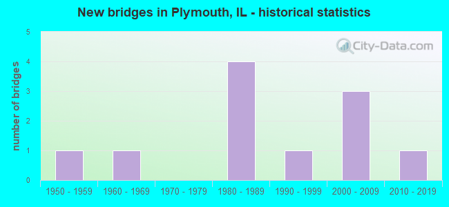
- New bridges - historical statistics
- 11950-1959
- 11960-1969
- 41980-1989
- 11990-1999
- 32000-2009
- 12010-2019


- Bridge Condition - Deck
- 9.1%Excellent
- 18.2%Very good
- 54.5%Good
- 9.1%Satisfactory
- 9.1%Fair

- Bridge Condition - Superstructure
- 27.3%Very good
- 54.5%Good
- 18.2%Satisfactory

- Bridge Condition - Substructure
- 54.5%Very good
- 9.1%Good
- 27.3%Satisfactory
- 9.1%Critical

- Bridge Condition - Channel
- 9.1%Very good
- 27.3%Good
- 45.5%Satisfactory
- 18.2%Fair
Find on map >> Show street view
Structure Number: 340502, Location: 3.6M N IL101-AUGUSTA (Lat: 40.276208, Lng: -90.920219), Route carried "on" structure: State highway 61, Year Built: 2001, Status: Open, Structure Length: 1.60m (5.25ft), Average Daily Traffic: 1,200 (year 2021), Truck Traffic: 15%, Average Future Daily Traffic: 1,000 (year 2032), Design Load: HS 20, Features Intersected: FLOUR CREEK
Minimum Vertical Clearance: 30+ m (98+ ft), Kilometerpoint: 55.891, Lanes on structure: 2, Base Highway Network: Yes, Owner: State Highway Agency, Approaching Roadway Width: 9.6m (31.5ft), Material/Design: Prestressed concrete, Design/Construction: Stringer/Multi-beam, Number Of Spans In Main Unit: 1, Length of Maximum Span: 15.1m (49.5ft), Curb-To-Curb Width: 9.6m (31.5ft), Out-to-Out Width: 10.6m (34.8ft)
Condition: Deck: Good, Superstructure: Very good, Substructure: Satisfactory, Channel: Very good, Operating Rating: 65.8 metric tons, Method Used To Determine Operating Rating: Load Factor (LF) rating reported by rating factor (RF) method using MS18 loading, Inventory Rating: 39.5 metric tons, Method Used To Determine Inventory Rating: Load Factor (LF) rating reported by rating factor (RF) method using MS18 loading, Structural Evaluation: Equal to present minimum criteria, Deck Geometry: Somewhat better than minimum adequacy, Waterway Adequacy: Superior to present desirable criteria, Approach Roadway Alignment: Equal to present desirable criteria, Designated Inspection Frequency: Every 24 months, Inspection Date: Febuary 2022, Deck Structure Type: Concrete Cast-file-Place, Wearing Surface/Protective System: Deck Protection: Epoxy Coated Reinforcing
Find on map >> Show street view
Structure Number: 34306, Location: 1.04 mi W of IL 61 (Lat: 40.343719, Lng: -90.914508), Route carried "on" structure: County highway , Year Built: 1968, Year Reconstructed: 2021, Status: Open, Structure Length: 14.33m (47.01ft), Average Daily Traffic: 200 (year 2014), Truck Traffic: 18%, Average Future Daily Traffic: 275 (year 2032), Design Load: HS 20, Features Intersected: La Moine River, Facility Carried by Structure: FAS 434 (CH 6)
Minimum Vertical Clearance: 30+ m (98+ ft), Kilometerpoint: 17.574, Lanes on structure: 2, Owner: County Highway Agency, Approaching Roadway Width: 6.7m (22.0ft), Skew: 3 degrees, Material/Design: Steel continuous, Design/Construction: Stringer/Multi-beam, Number Of Spans In Main Unit: 6, Length of Maximum Span: 33.5m (109.9ft), Curb-To-Curb Width: 8.2m (26.9ft), Out-to-Out Width: 9.1m (29.9ft)
Condition: Deck: Excellent, Superstructure: Good, Substructure: Very good, Channel: Good, Operating Rating: 60.9 metric tons, Method Used To Determine Operating Rating: Load Factor (LF) rating reported by rating factor (RF) method using MS18 loading, Inventory Rating: 36.6 metric tons, Method Used To Determine Inventory Rating: Load Factor (LF) rating reported by rating factor (RF) method using MS18 loading, Structural Evaluation: Better than present minimum criteria, Deck Geometry: Somewhat better than minimum adequacy, Waterway Adequacy: Better than present minimum criteria, Approach Roadway Alignment: Equal to present minimum criteria, Designated Inspection Frequency: Every 24 months, Inspection Date: December 2021, Deck Structure Type: Concrete Cast-file-Place, Wearing Surface/Protective System: Deck Protection: Epoxy Coated Reinforcing
Find on map >> Show street view
Structure Number: 345409, Location: 2.0 SW ST MARY (Lat: 40.323842, Lng: -90.966636), Route carried "on" structure: County highway , Year Built: 1981, Status: Open, Structure Length: 2.96m (9.71ft), Average Daily Traffic: 25 (year 2020), Average Future Daily Traffic: 25 (year 2032), Design Load: HS 20, Features Intersected: BRONSON CREEK, Facility Carried by Structure: TR 334
Minimum Vertical Clearance: 30+ m (98+ ft), Kilometerpoint: 3.685, Lanes on structure: 2, Owner: Town or Township Highway Agency, Approaching Roadway Width: 4.3m (14.1ft), Material/Design: Prestressed concrete, Design/Construction: Box Beam or Girders - Multiple, Number Of Spans In Main Unit: 3, Length of Maximum Span: 12.8m (42.0ft), Curb-To-Curb Width: 8.3m (27.2ft), Out-to-Out Width: 8.3m (27.2ft)
Condition: Deck: Good, Superstructure: Good, Substructure: Very good, Channel: Satisfactory, Operating Rating: 44.4 metric tons, Method Used To Determine Operating Rating: Assigned rating based on Load Factor Design (LFD) reported by rating factor (RF) using MS18 loading, Inventory Rating: 32.4 metric tons, Method Used To Determine Inventory Rating: Assigned rating based on Load Factor Design (LFD) reported by rating factor (RF) using MS18 loading, Structural Evaluation: Better than present minimum criteria, Deck Geometry: Equal to present minimum criteria, Waterway Adequacy: Somewhat better than minimum adequacy, Approach Roadway Alignment: Equal to present desirable criteria, Designated Inspection Frequency: Every 48 months, Inspection Date: March 2018, Deck Structure Type: Concrete Precast Panels, Wearing Surface/Protective System: Wearing Surface: Gravel
Find on map >> Show street view
Structure Number: 345421, Location: 2.0 SW ST MARY (Lat: 40.312275, Lng: -90.966739), Route carried "on" structure: County highway , Year Built: 1983, Status: Open, Structure Length: 3.29m (10.79ft), Average Daily Traffic: 25 (year 2020), Average Future Daily Traffic: 25 (year 2032), Design Load: HS 20, Features Intersected: PANTHER CREEK, Facility Carried by Structure: TR 334
Minimum Vertical Clearance: 30+ m (98+ ft), Kilometerpoint: 4.973, Lanes on structure: 2, Owner: Town or Township Highway Agency, Approaching Roadway Width: 4.9m (16.1ft), Material/Design: Concrete, Design/Construction: Channel Beam, Number Of Spans In Main Unit: 3, Length of Maximum Span: 11.6m (38.1ft), Curb-To-Curb Width: 8.1m (26.6ft), Out-to-Out Width: 8.1m (26.6ft)
Condition: Deck: Very good, Superstructure: Satisfactory, Substructure: Satisfactory, Channel: Fair, Operating Rating: 44.4 metric tons, Method Used To Determine Operating Rating: Assigned rating based on Load Factor Design (LFD) reported by rating factor (RF) using MS18 loading, Inventory Rating: 32.4 metric tons, Method Used To Determine Inventory Rating: Assigned rating based on Load Factor Design (LFD) reported by rating factor (RF) using MS18 loading, Structural Evaluation: Equal to present minimum criteria, Deck Geometry: Equal to present minimum criteria, Waterway Adequacy: Equal to present desirable criteria, Approach Roadway Alignment: Equal to present minimum criteria, Designated Inspection Frequency: Every 24 months, Inspection Date: March 2020, Deck Structure Type: Concrete Precast Panels
Find on map >> Show street view
Structure Number: 345422, Location: 1.5 MI NW PLYMOUTH (Lat: 40.311503, Lng: -90.940644), Route carried "on" structure: County highway , Year Built: 1959, Status: Open, Structure Length: 3.81m (12.50ft), Average Daily Traffic: 100 (year 2018), Truck Traffic: 22%, Average Future Daily Traffic: 125 (year 2032), Design Load: HS 15, Features Intersected: BRONSON CREEK, Facility Carried by Structure: TR 356
Minimum Vertical Clearance: 30+ m (98+ ft), Kilometerpoint: 8.867, Lanes on structure: 2, Owner: Town or Township Highway Agency, Approaching Roadway Width: 5.5m (18.0ft), Material/Design: Steel continuous, Design/Construction: Stringer/Multi-beam, Number Of Spans In Main Unit: 3, Length of Maximum Span: 14.3m (46.9ft), Curb-To-Curb Width: 7.4m (24.3ft), Out-to-Out Width: 8.7m (28.5ft)
Condition: Deck: Good, Superstructure: Good, Substructure: Critical, Channel: Satisfactory, Operating Rating: 37.3 metric tons, Method Used To Determine Operating Rating: Load Factor (LF) rating reported by rating factor (RF) method using MS18 loading, Inventory Rating: 22.4 metric tons, Method Used To Determine Inventory Rating: Load Factor (LF) rating reported by rating factor (RF) method using MS18 loading, Structural Evaluation: High priority of replacement, Deck Geometry: Equal to present minimum criteria, Waterway Adequacy: Equal to present desirable criteria, Approach Roadway Alignment: Equal to present minimum criteria, Bridge Posting: Required (Relationship of Operating Rating to Maximum Legal Load: 20.0 - 29.9% below), Designated Inspection Frequency: Every 24 months, Inspection Date: Febuary 2021, Deck Structure Type: Concrete Cast-file-Place, Wearing Surface/Protective System: Wearing Surface: Gravel
Find on map >> Show street view
Structure Number: 345425, Location: 1.8MI N PLYMOUTH (Lat: 40.324819, Lng: -90.918836), Route carried "on" structure: County highway , Year Built: 1997, Status: Open, Structure Length: 6.92m (22.70ft), Average Daily Traffic: 100 (year 2018), Truck Traffic: 34%, Average Future Daily Traffic: 175 (year 2032), Design Load: HS 20, Features Intersected: BRONSON CREEK, Facility Carried by Structure: TR 414
Minimum Vertical Clearance: 30+ m (98+ ft), Kilometerpoint: 2.446, Lanes on structure: 2, Owner: Town or Township Highway Agency, Approaching Roadway Width: 5.5m (18.0ft), Skew: 2 degrees, Material/Design: Prestressed concrete, Design/Construction: Box Beam or Girders - Multiple, Number Of Spans In Main Unit: 3, Length of Maximum Span: 22.9m (75.1ft), Curb-To-Curb Width: 8.3m (27.2ft), Out-to-Out Width: 8.3m (27.2ft)
Condition: Deck: Good, Superstructure: Good, Substructure: Very good, Channel: Good, Operating Rating: 44.1 metric tons, Method Used To Determine Operating Rating: Assigned rating based on Load Factor Design (LFD) reported by rating factor (RF) using MS18 loading, Inventory Rating: 32.4 metric tons, Method Used To Determine Inventory Rating: Assigned rating based on Load Factor Design (LFD) reported by rating factor (RF) using MS18 loading, Structural Evaluation: Better than present minimum criteria, Deck Geometry: Equal to present minimum criteria, Waterway Adequacy: Equal to present desirable criteria, Approach Roadway Alignment: Equal to present desirable criteria, Designated Inspection Frequency: Every 48 months, Inspection Date: May 2019, Deck Structure Type: Concrete Precast Panels
Find on map >> Show street view
Structure Number: 550083, Location: 1 MI S OF COLMAR (Lat: 40.332217, Lng: -90.896128), Route carried "on" structure: State highway 61, Year Built: 2011, Status: Open, Structure Length: 14.58m (47.83ft), Average Daily Traffic: 1,000 (year 2021), Truck Traffic: 21%, Average Future Daily Traffic: 1,075 (year 2032), Design Load: HS 25 or greater, Features Intersected: La MOINE RIVER
Minimum Vertical Clearance: 30+ m (98+ ft), Kilometerpoint: 63.503, Lanes on structure: 2, Base Highway Network: Yes, Owner: State Highway Agency, Approaching Roadway Width: 9.8m (32.2ft), Material/Design: Prestressed concrete continuous, Design/Construction: Stringer/Multi-beam, Number Of Spans In Main Unit: 5, Length of Maximum Span: 33.5m (109.9ft), Curb-To-Curb Width: 9.8m (32.2ft), Out-to-Out Width: 10.7m (35.1ft)
Condition: Deck: Fair, Superstructure: Very good, Substructure: Very good, Channel: Satisfactory, Operating Rating: 89.1 metric tons, Method Used To Determine Operating Rating: Load Factor (LF) rating reported by rating factor (RF) method using MS18 loading, Inventory Rating: 48.3 metric tons, Method Used To Determine Inventory Rating: Load Factor (LF) rating reported by rating factor (RF) method using MS18 loading, Structural Evaluation: Equal to present desirable criteria, Deck Geometry: Equal to present minimum criteria, Waterway Adequacy: Equal to present minimum criteria, Approach Roadway Alignment: Equal to present minimum criteria, Designated Inspection Frequency: Every 24 months, Inspection Date: December 2019, Deck Structure Type: Concrete Cast-file-Place, Wearing Surface/Protective System: Deck Protection: Epoxy Coated Reinforcing
Find on map >> Show street view
Structure Number: 555304, Location: CTR-21-T4NR4W (Lat: 40.319664, Lng: -90.860022), Route carried "on" structure: County highway , Year Built: 1980, Status: Open, Structure Length: 4.30m (14.11ft), Average Daily Traffic: 75 (year 2016), Average Future Daily Traffic: 77 (year 2032), Design Load: HS 20, Features Intersected: LAMOINE RIVER, Facility Carried by Structure: TR 58
Minimum Vertical Clearance: 30+ m (98+ ft), Kilometerpoint: 9.688, Lanes on structure: 2, Owner: Town or Township Highway Agency, Approaching Roadway Width: 5.5m (18.0ft), Material/Design: Prestressed concrete, Design/Construction: Box Beam or Girders - Multiple, Number Of Spans In Main Unit: 3, Length of Maximum Span: 14.0m (45.9ft), Curb-To-Curb Width: 8.6m (28.2ft), Out-to-Out Width: 8.7m (28.5ft)
Condition: Deck: Satisfactory, Superstructure: Satisfactory, Substructure: Good, Channel: Fair, Operating Rating: 53.8 metric tons, Method Used To Determine Operating Rating: Load Factor (LF) rating reported by rating factor (RF) method using MS18 loading, Inventory Rating: 32.4 metric tons, Method Used To Determine Inventory Rating: Load Factor (LF) rating reported by rating factor (RF) method using MS18 loading, Structural Evaluation: Equal to present minimum criteria, Deck Geometry: Better than present minimum criteria, Waterway Adequacy: Equal to present desirable criteria, Approach Roadway Alignment: High priority of corrective action, Designated Inspection Frequency: Every 24 months, Inspection Date: January 2021, Deck Structure Type: Concrete Precast Panels
Find on map >> Show street view
Structure Number: 555308, Location: S.CTR-28-T4NR4W (Lat: 40.297397, Lng: -90.859850), Route carried "on" structure: County highway , Year Built: 1987, Status: Open, Structure Length: 1.28m (4.20ft), Average Daily Traffic: 50 (year 2016), Average Future Daily Traffic: 51 (year 2032), Design Load: HS 20, Features Intersected: HOGWALLOW BRANCH, Facility Carried by Structure: POLLOCK RD-TR 58
Minimum Vertical Clearance: 30+ m (98+ ft), Kilometerpoint: 12.247, Lanes on structure: 2, Owner: Town or Township Highway Agency, Approaching Roadway Width: 4.9m (16.1ft), Material/Design: Prestressed concrete, Design/Construction: Box Beam or Girders - Multiple, Number Of Spans In Main Unit: 1, Length of Maximum Span: 12.2m (40.0ft), Curb-To-Curb Width: 7.4m (24.3ft), Out-to-Out Width: 7.4m (24.3ft)
Condition: Deck: Good, Superstructure: Good, Substructure: Very good, Channel: Satisfactory, Operating Rating: 44.4 metric tons, Method Used To Determine Operating Rating: Assigned rating based on Load Factor Design (LFD) reported by rating factor (RF) using MS18 loading, Inventory Rating: 32.4 metric tons, Method Used To Determine Inventory Rating: Assigned rating based on Load Factor Design (LFD) reported by rating factor (RF) using MS18 loading, Structural Evaluation: Better than present minimum criteria, Deck Geometry: Equal to present minimum criteria, Waterway Adequacy: Better than present minimum criteria, Approach Roadway Alignment: Better than present minimum criteria, Designated Inspection Frequency: Every 48 months, Inspection Date: January 2021, Deck Structure Type: Concrete Precast Panels, Wearing Surface/Protective System: Wearing Surface: Bituminous
Find on map >> Show street view
Structure Number: 555311, Location: SW-16-T4NR4W (Lat: 40.332583, Lng: -90.864333), Route carried "on" structure: County highway , Year Built: 2005, Status: Open, Structure Length: 3.35m (10.99ft), Average Daily Traffic: 25 (year 2016), Average Future Daily Traffic: 26 (year 2032), Design Load: HS 20, Features Intersected: TROUBLESOME CREEK, Facility Carried by Structure: TR 58
Minimum Vertical Clearance: 30+ m (98+ ft), Kilometerpoint: 7.837, Lanes on structure: 2, Owner: Town or Township Highway Agency, Approaching Roadway Width: 4.9m (16.1ft), Skew: 3 degrees, Material/Design: Concrete, Design/Construction: Channel Beam, Number Of Spans In Main Unit: 3, Length of Maximum Span: 11.0m (36.1ft), Curb-To-Curb Width: 8.0m (26.2ft), Out-to-Out Width: 8.0m (26.2ft)
Condition: Deck: Very good, Superstructure: Very good, Substructure: Very good, Channel: Good, Operating Rating: 44.1 metric tons, Method Used To Determine Operating Rating: Assigned rating based on Load Factor Design (LFD) reported by rating factor (RF) using MS18 loading, Inventory Rating: 32.4 metric tons, Method Used To Determine Inventory Rating: Assigned rating based on Load Factor Design (LFD) reported by rating factor (RF) using MS18 loading, Structural Evaluation: Equal to present desirable criteria, Deck Geometry: Equal to present minimum criteria, Waterway Adequacy: Meets minimum limits, Approach Roadway Alignment: Equal to present desirable criteria, Designated Inspection Frequency: Every 48 months, Inspection Date: January 2021, Deck Structure Type: Concrete Precast Panels, Wearing Surface/Protective System: Wearing Surface: Bituminous, Membrane: Built-up
Find on map >> Show street view
Structure Number: 854212, Location: 2.5 W BRMINGHM (Lat: 40.252744, Lng: -90.864981), Route carried "on" structure: County highway , Year Built: 2008, Status: Open, Structure Length: 2.33m (7.64ft), Average Daily Traffic: 25 (year 2019), Truck Traffic: 8%, Average Future Daily Traffic: 25 (year 2032), Design Load: HS 20, Features Intersected: FLOWER BRANCH, Facility Carried by Structure: TR 38
Minimum Vertical Clearance: 30+ m (98+ ft), Kilometerpoint: 1.561, Lanes on structure: 2, Owner: Town or Township Highway Agency, Approaching Roadway Width: 6.1m (20.0ft), Material/Design: Prestressed concrete, Design/Construction: Box Beam or Girders - Multiple, Number Of Spans In Main Unit: 1, Length of Maximum Span: 22.6m (74.1ft), Curb-To-Curb Width: 7.3m (24.0ft), Out-to-Out Width: 7.3m (24.0ft)
Condition: Deck: Good, Superstructure: Good, Substructure: Satisfactory, Channel: Satisfactory, Operating Rating: 44.1 metric tons, Method Used To Determine Operating Rating: Assigned rating based on Load Factor Design (LFD) reported by rating factor (RF) using MS18 loading, Inventory Rating: 32.4 metric tons, Method Used To Determine Inventory Rating: Assigned rating based on Load Factor Design (LFD) reported by rating factor (RF) using MS18 loading, Structural Evaluation: Equal to present minimum criteria, Deck Geometry: Equal to present minimum criteria, Waterway Adequacy: Equal to present desirable criteria, Approach Roadway Alignment: Better than present minimum criteria, Designated Inspection Frequency: Every 24 months, Inspection Date: November 2020, Deck Structure Type: Concrete Precast Panels