Bridge Statistics for Pocono Woodland Lakes, Pennsylvania (PA)
Condition, Traffic, Stress, Structural Evaluation, Project Costs
- National Bridge Inventory (NBI) Statistics
- 17Number of bridges
- 128ft / 39.0mTotal length
- $5,607,000Total costs
- 99,334Total average daily traffic
- 18,308Total average daily truck traffic
- National Bridge Inventory (NBI) Registered Bridges for Pocono Woodland Lakes
- No street view available for this location
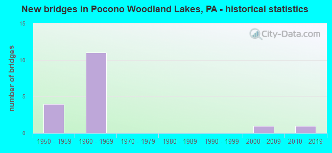
- New bridges - historical statistics
- 41950-1959
- 111960-1969
- 12000-2009
- 12010-2019


- Bridge Condition - Deck
- 12.5%Very good
- 25.0%Good
- 37.5%Satisfactory
- 25.0%Fair

- Bridge Condition - Superstructure
- 10.0%Excellent
- 10.0%Good
- 20.0%Satisfactory
- 50.0%Fair
- 10.0%Serious

- Bridge Condition - Substructure
- 10.0%Very good
- 10.0%Good
- 50.0%Satisfactory
- 30.0%Fair

- Bridge Condition - Channel
- 14.3%Good
- 42.9%Satisfactory
- 14.3%Fair
- 28.6%Poor
Find on map >> Show street view
Structure Number: 29804, Location: DINGMAN TWP 2.3 M W I-84 (Lat: 41.351325, Lng: -74.876497), Route carried "on" structure: US 6, Year Built: 1957, Status: Open, Structure Length: 0.85m (2.79ft), Average Daily Traffic: 8,136 (year 2020), Truck Traffic: 5%, Average Future Daily Traffic: 12,127 (year 2032), Design Load: HS 20, Features Intersected: SAWKILL CREEK
Minimum Vertical Clearance: 30+ m (98+ ft), Kilometerpoint: 31.157, Lanes on structure: 2, Base Highway Network: Yes, Owner: State Highway Agency, Approaching Roadway Width: 10.1m (33.1ft), Material/Design: Prestressed concrete, Design/Construction: Box Beam or Girders - Multiple, Number Of Spans In Main Unit: 1, Length of Maximum Span: 7.9m (25.9ft)
Condition: Superstructure: Serious, Substructure: Fair, Channel: Poor, Inventory Rating: 52.6 metric tons, Method Used To Determine Inventory Rating: Load Factor (LF), Structural Evaluation: High priority of corrective action, Waterway Adequacy: Equal to present minimum criteria, Approach Roadway Alignment: Equal to present desirable criteria, Length Of Structure Improvement: 0.90m (2.95ft), Designated Inspection Frequency: Every 24 months, Other Special Inspection Frequency: Every 6 months, Inspection Date: June 2021, Other Special Inspection Date: June 2021, Bridge Improvement Cost: $17,000, Roadway Improvement Cost: $100,000, Total Project Cost: $228,000
Find on map >> Show street view
Structure Number: 29805, Location: MILFORD TWP OVER I-84 (Lat: 41.338483, Lng: -74.837314), Route carried "on" structure: US 6, Year Built: 1968, Year Reconstructed: 2009, Status: Open, Structure Length: 10.12m (33.20ft), Average Daily Traffic: 8,300 (year 2020), Truck Traffic: 5%, Average Future Daily Traffic: 12,608 (year 2032), Design Load: HS 20, Features Intersected: SR 0084 I-84 EB & WB
Minimum Vertical Clearance: 30+ m (98+ ft), Kilometerpoint: 35.143, Lanes on structure: 2, Lanes under structure: 6, Base Highway Network: Yes, Owner: State Highway Agency, Approaching Roadway Width: 19.8m (65.0ft), Skew: 22 degrees, Material/Design: Prestressed concrete, Design/Construction: Box Beam or Girders - Single/Spread, Number Of Spans In Main Unit: 5, Length of Maximum Span: 22.9m (75.1ft), Curb or Sidewalk Widths: Left: 0.2m (0.7ft), Right: 0.2m (0.7ft), Curb-To-Curb Width: 18.7m (61.4ft), Out-to-Out Width: 20.0m (65.6ft)
Condition: Deck: Good, Superstructure: Fair, Substructure: Satisfactory, Operating Rating: 63.5 metric tons, Method Used To Determine Operating Rating: Load Factor (LF), Inventory Rating: 29.9 metric tons, Method Used To Determine Inventory Rating: Load Factor (LF), Structural Evaluation: Somewhat better than minimum adequacy, Deck Geometry: Superior to present desirable criteria, Underclear: Somewhat better than minimum adequacy, Approach Roadway Alignment: Equal to present desirable criteria, Length Of Structure Improvement: 9.80m (32.15ft), Designated Inspection Frequency: Every 24 months, Inspection Date: June 2021, Bridge Improvement Cost: $153,000, Roadway Improvement Cost: $451,000, Total Project Cost: $2,067,000, Deck Structure Type: Concrete Cast-file-Place, Wearing Surface/Protective System: Wearing Surface: Monolithic Concrete, Deck Protection: Epoxy Coated Reinforcing
Find on map >> Show street view
Structure Number: 29854, Location: DINGMAN TWP OVER SR 2011 (Lat: 41.340081, Lng: -74.877117), Route carried "on" structure: Interstate 84, Year Built: 1968, Year Reconstructed: 2006, Status: Open, Structure Length: 4.08m (13.39ft), Average Daily Traffic: 11,004 (year 2021), Truck Traffic: 26%, Average Future Daily Traffic: 13,869 (year 2032), Design Load: HS 20+Mod, Features Intersected: SR 2011
Minimum Vertical Clearance: 30+ m (98+ ft), Kilometerpoint: 39.524, Lanes on structure: 2, Lanes under structure: 2, Base Highway Network: Yes, Owner: State Highway Agency, Approaching Roadway Width: 11.3m (37.1ft), Skew: 13 degrees, Material/Design: Prestressed concrete, Design/Construction: Box Beam or Girders - Single/Spread, Number Of Spans In Main Unit: 3, Length of Maximum Span: 15.2m (49.9ft), Curb or Sidewalk Widths: Left: 0.2m (0.7ft), Right: 0.2m (0.7ft), Curb-To-Curb Width: 11.7m (38.4ft), Out-to-Out Width: 13.0m (42.7ft)
Condition: Deck: Satisfactory, Superstructure: Satisfactory, Substructure: Fair, Operating Rating: 48.1 metric tons, Method Used To Determine Operating Rating: Load Factor (LF), Inventory Rating: 26.3 metric tons, Method Used To Determine Inventory Rating: Load Factor (LF), Structural Evaluation: Somewhat better than minimum adequacy, Deck Geometry: Equal to present minimum criteria, Underclear: Meets minimum limits, Approach Roadway Alignment: Equal to present desirable criteria, Length Of Structure Improvement: 4.10m (13.45ft), Designated Inspection Frequency: Every 24 months, Inspection Date: Febuary 2021, Bridge Improvement Cost: $59,000, Roadway Improvement Cost: $174,000, Total Project Cost: $798,000, Deck Structure Type: Concrete Cast-file-Place, Wearing Surface/Protective System: Wearing Surface: Latex Concrete
Find on map >> Show street view
Structure Number: 29855, Location: DINGMAN TWP OVER SR 2011 (Lat: 41.340722, Lng: -74.877622), Route carried "on" structure: Interstate 84, Year Built: 1968, Status: Open, Structure Length: 3.66m (12.01ft), Average Daily Traffic: 10,739 (year 2021), Truck Traffic: 25%, Average Future Daily Traffic: 12,339 (year 2032), Design Load: HS 20+Mod, Features Intersected: SR 2011
Minimum Vertical Clearance: 30+ m (98+ ft), Kilometerpoint: 39.480, Lanes on structure: 2, Lanes under structure: 2, Base Highway Network: Yes, Owner: State Highway Agency, Approaching Roadway Width: 11.3m (37.1ft), Skew: 13 degrees, Material/Design: Prestressed concrete, Design/Construction: Box Beam or Girders - Single/Spread, Number Of Spans In Main Unit: 3, Length of Maximum Span: 14.3m (46.9ft), Curb or Sidewalk Widths: Left: 0.2m (0.7ft), Right: 0.2m (0.7ft), Curb-To-Curb Width: 11.7m (38.4ft), Out-to-Out Width: 13.0m (42.7ft)
Condition: Deck: Satisfactory, Superstructure: Satisfactory, Substructure: Satisfactory, Operating Rating: 44.5 metric tons, Method Used To Determine Operating Rating: Load Factor (LF), Inventory Rating: 26.3 metric tons, Method Used To Determine Inventory Rating: Load Factor (LF), Structural Evaluation: Equal to present minimum criteria, Deck Geometry: Equal to present minimum criteria, Underclear: Meets minimum limits, Approach Roadway Alignment: Equal to present desirable criteria, Length Of Structure Improvement: 4.60m (15.09ft), Designated Inspection Frequency: Every 24 months, Inspection Date: Febuary 2021, Bridge Improvement Cost: $18,000, Roadway Improvement Cost: $85,000, Total Project Cost: $248,000, Deck Structure Type: Concrete Cast-file-Place, Wearing Surface/Protective System: Wearing Surface: Latex Concrete
Find on map >> Show street view
Structure Number: 29966, Location: DINGMAN TWP .3M N SR 2009 (Lat: 41.305761, Lng: -74.851453), Route carried "on" structure: State highway , Year Built: 1958, Status: Open, Structure Length: 1.34m (4.40ft), Average Daily Traffic: 6,696 (year 2022), Truck Traffic: 2%, Average Future Daily Traffic: 10,566 (year 2032), Design Load: HS 20, Features Intersected: RAYMONDSKILL CREEK, Facility Carried by Structure: SR 2001
Minimum Vertical Clearance: 30+ m (98+ ft), Kilometerpoint: 28.960, Lanes on structure: 2, Owner: State Highway Agency, Approaching Roadway Width: 9.1m (29.9ft), Material/Design: Steel, Design/Construction: Stringer/Multi-beam, Number Of Spans In Main Unit: 1, Length of Maximum Span: 12.8m (42.0ft), Curb-To-Curb Width: 9.1m (29.9ft), Out-to-Out Width: 9.8m (32.2ft)
Condition: Deck: Fair, Superstructure: Fair, Substructure: Satisfactory, Channel: Satisfactory, Operating Rating: 50.8 metric tons, Method Used To Determine Operating Rating: Load Factor (LF), Inventory Rating: 29.9 metric tons, Method Used To Determine Inventory Rating: Load Factor (LF), Structural Evaluation: Somewhat better than minimum adequacy, Deck Geometry: High priority of corrective action, Waterway Adequacy: Equal to present desirable criteria, Approach Roadway Alignment: Better than present minimum criteria, Length Of Structure Improvement: 1.30m (4.27ft), Designated Inspection Frequency: Every 24 months, Inspection Date: June 2021, Bridge Improvement Cost: $13,000, Roadway Improvement Cost: $100,000, Total Project Cost: $177,000, Deck Structure Type: Concrete Cast-file-Place, Wearing Surface/Protective System: Wearing Surface: Bituminous
Find on map >> Show street view
Structure Number: 29985, Location: DINGMAN TWP .8M S SR 2001 (Lat: 41.294583, Lng: -74.846508), Route carried "on" structure: State highway , Year Built: 1961, Status: Open, Structure Length: 1.58m (5.18ft), Average Daily Traffic: 321 (year 2022), Truck Traffic: 4%, Average Future Daily Traffic: 378 (year 2032), Design Load: HS 20, Features Intersected: RAYMONDSKILL CREEK, Facility Carried by Structure: SR 2009
Minimum Vertical Clearance: 30+ m (98+ ft), Kilometerpoint: 1.455, Lanes on structure: 2, Owner: State Highway Agency, Approaching Roadway Width: 5.5m (18.0ft), Material/Design: Prestressed concrete, Design/Construction: Box Beam or Girders - Multiple, Number Of Spans In Main Unit: 1, Length of Maximum Span: 15.2m (49.9ft)
Condition: Superstructure: Fair, Substructure: Satisfactory, Channel: Satisfactory, Operating Rating: 68.0 metric tons, Method Used To Determine Operating Rating: Load Factor (LF), Inventory Rating: 26.3 metric tons, Method Used To Determine Inventory Rating: Load Factor (LF), Structural Evaluation: Somewhat better than minimum adequacy, Waterway Adequacy: Superior to present desirable criteria, Approach Roadway Alignment: Equal to present desirable criteria, Length Of Structure Improvement: 1.60m (5.25ft), Designated Inspection Frequency: Every 24 months, Inspection Date: July 2021, Bridge Improvement Cost: $13,000, Roadway Improvement Cost: $100,000, Total Project Cost: $171,000
Find on map >> Show street view
Structure Number: 29986, Location: DINGMAN TWP 500'N SR 2001 (Lat: 41.303331, Lng: -74.855331), Route carried "on" structure: State highway , Year Built: 1954, Status: Open, Structure Length: 1.34m (4.40ft), Average Daily Traffic: 266 (year 2020), Truck Traffic: 3%, Average Future Daily Traffic: 389 (year 2032), Design Load: HS 20, Features Intersected: RAYMONDSKILL CREEK, Facility Carried by Structure: SR 2009
Minimum Vertical Clearance: 30+ m (98+ ft), Kilometerpoint: 2.784, Lanes on structure: 2, Owner: State Highway Agency, Approaching Roadway Width: 5.5m (18.0ft), Material/Design: Steel, Design/Construction: Stringer/Multi-beam, Number Of Spans In Main Unit: 1, Length of Maximum Span: 12.8m (42.0ft), Curb or Sidewalk Widths: Left: 0.2m (0.7ft), Right: 0.2m (0.7ft), Curb-To-Curb Width: 7.3m (24.0ft), Out-to-Out Width: 8.0m (26.2ft)
Condition: Deck: Fair, Superstructure: Fair, Substructure: Fair, Channel: Poor, Operating Rating: 49.0 metric tons, Method Used To Determine Operating Rating: Load Factor (LF), Inventory Rating: 29.0 metric tons, Method Used To Determine Inventory Rating: Load Factor (LF), Structural Evaluation: Somewhat better than minimum adequacy, Deck Geometry: Somewhat better than minimum adequacy, Waterway Adequacy: Equal to present minimum criteria, Approach Roadway Alignment: Better than present minimum criteria, Length Of Structure Improvement: 1.30m (4.27ft), Designated Inspection Frequency: Every 24 months, Inspection Date: July 2021, Bridge Improvement Cost: $16,000, Roadway Improvement Cost: $100,000, Total Project Cost: $214,000, Deck Structure Type: Concrete Cast-file-Place, Wearing Surface/Protective System: Wearing Surface: Monolithic Concrete
Find on map >> Show street view
Structure Number: 29988, Location: DINGMAN TWP OVER I-84 (Lat: 41.341469, Lng: -74.904689), Route carried "on" structure: State highway , Year Built: 1966, Status: Open, Structure Length: 12.22m (40.09ft), Average Daily Traffic: 266 (year 2020), Truck Traffic: 3%, Average Future Daily Traffic: 389 (year 2032), Design Load: HS 20, Features Intersected: SR 0084 I-84, Facility Carried by Structure: SR2009 RAYMONDSKIL
Minimum Vertical Clearance: 30+ m (98+ ft), Kilometerpoint: 12.101, Lanes on structure: 2, Lanes under structure: 4, Owner: State Highway Agency, Approaching Roadway Width: 7.9m (25.9ft), Skew: 2 degrees, Material/Design: Prestressed concrete, Design/Construction: Box Beam or Girders - Single/Spread, Number Of Spans In Main Unit: 6, Length of Maximum Span: 25.0m (82.0ft), Curb or Sidewalk Widths: Left: 0.2m (0.7ft), Right: 0.2m (0.7ft), Curb-To-Curb Width: 9.0m (29.5ft), Out-to-Out Width: 10.2m (33.5ft)
Condition: Deck: Satisfactory, Superstructure: Fair, Substructure: Satisfactory, Operating Rating: 59.0 metric tons, Method Used To Determine Operating Rating: Load Factor (LF), Inventory Rating: 35.4 metric tons, Method Used To Determine Inventory Rating: Load Factor (LF), Structural Evaluation: Somewhat better than minimum adequacy, Deck Geometry: Equal to present minimum criteria, Underclear: Somewhat better than minimum adequacy, Approach Roadway Alignment: Better than present minimum criteria, Length Of Structure Improvement: 12.20m (40.03ft), Designated Inspection Frequency: Every 24 months, Inspection Date: July 2021, Bridge Improvement Cost: $122,000, Roadway Improvement Cost: $358,000, Total Project Cost: $1,642,000, Deck Structure Type: Concrete Cast-file-Place, Wearing Surface/Protective System: Wearing Surface: Latex Concrete
Find on map >> Show street view
Structure Number: 45426, Location: MILFORD (Lat: 41.360100, Lng: -74.855697), Route carried "on" structure: ServiceState lands road , Year Built: 2002, Status: Open, Structure Length: 0.88m (2.89ft), Average Daily Traffic: 100 (year 2016), Average Future Daily Traffic: 8 (year 2030), Design Load: HS 20, Features Intersected: CRAFT BROOK, Facility Carried by Structure: SCHOCOPEE ROAD
Minimum Vertical Clearance: 30+ m (98+ ft), Kilometerpoint: 0.000, Lanes on structure: 1, Owner: State Park, Forest, or Reservation Agency, Approaching Roadway Width: 3.0m (9.8ft), Material/Design: Concrete, Design/Construction: Culvert, Number Of Spans In Main Unit: 1, Length of Maximum Span: 2.4m (7.9ft), Curb-To-Curb Width: 3.6m (11.8ft), Out-to-Out Width: 4.6m (15.1ft)
Condition: Channel: Fair, Culverts: Satisfactory, Operating Rating: 76.2 metric tons, Method Used To Determine Operating Rating: Load Factor (LF), Inventory Rating: 45.4 metric tons, Method Used To Determine Inventory Rating: Load Factor (LF), Structural Evaluation: Equal to present minimum criteria, Deck Geometry: High priority of corrective action, Waterway Adequacy: Better than present minimum criteria, Approach Roadway Alignment: Equal to present desirable criteria, Length Of Structure Improvement: 0.90m (2.95ft), Designated Inspection Frequency: Every 24 months, Inspection Date: July 2020
Find on map >> Show street view
Structure Number: 47763, Location: DINGMAN TWP 3 M E TR 739 (Lat: 41.297094, Lng: -74.908556), Route carried "on" structure: State highway , Year Built: 2012, Status: Open, Structure Length: 1.34m (4.40ft), Average Daily Traffic: 3,065 (year 2021), Truck Traffic: 4%, Average Future Daily Traffic: 3,917 (year 2033), Design Load: HL 93, Features Intersected: DWARFSKILL CREEK, Facility Carried by Structure: SR 2006
Minimum Vertical Clearance: 30+ m (98+ ft), Kilometerpoint: 5.258, Lanes on structure: 2, Owner: State Highway Agency, Approaching Roadway Width: 8.5m (27.9ft), Skew: 5 degrees, Material/Design: Prestressed concrete, Design/Construction: Box Beam or Girders - Single/Spread, Number Of Spans In Main Unit: 1, Length of Maximum Span: 12.8m (42.0ft), Curb or Sidewalk Widths: Left: 0.2m (0.7ft), Right: 0.2m (0.7ft), Curb-To-Curb Width: 11.9m (39.0ft), Out-to-Out Width: 13.0m (42.7ft)
Condition: Deck: Very good, Superstructure: Excellent, Substructure: Very good, Channel: Good, Operating Rating: 54.4 metric tons, Method Used To Determine Operating Rating: Assigned ratings based on Load and Resistance Factor Design (LRFD) reported by rating factor (RF) using HL93 loadings, Inventory Rating: 34.3 metric tons, Method Used To Determine Inventory Rating: Assigned ratings based on Load and Resistance Factor Design (LRFD) reported by rating factor (RF) using HL93 loadings, Structural Evaluation: Equal to present desirable criteria, Deck Geometry: Somewhat better than minimum adequacy, Waterway Adequacy: Better than present minimum criteria, Approach Roadway Alignment: Better than present minimum criteria, Designated Inspection Frequency: Every 48 months, Inspection Date: July 2019, Deck Structure Type: Concrete Cast-file-Place, Wearing Surface/Protective System: Wearing Surface: Epoxy Overlay, Deck Protection: Epoxy Coated Reinforcing
Find on map >> Show street view
Structure Number: 4320014P, Location: 2.7 MILES SOUTH OF ROUTE (Lat: 41.287111, Lng: -74.834222), Route carried "on" structure: Federal lands road 14, Year Built: 1955, Year Reconstructed: 2012, Status: Open, Structure Length: 1.59m (5.22ft), Average Daily Traffic: 5,000 (year 2019), Truck Traffic: 10%, Average Future Daily Traffic: 6,000 (year 2039), Design Load: HL 93, Features Intersected: RAYMONDSKILL CREEK, Facility Carried by Structure: U.S. ROUTE 209
Minimum Vertical Clearance: 30+ m (98+ ft), Kilometerpoint: 29.451, Lanes on structure: 2, Owner: National Park Service, Approaching Roadway Width: 10.4m (34.1ft), Skew: 3 degrees, Material/Design: Prestressed concrete, Design/Construction: Box Beam or Girders - Multiple, Number Of Spans In Main Unit: 1, Length of Maximum Span: 14.6m (47.9ft), Curb-To-Curb Width: 12.4m (40.7ft), Out-to-Out Width: 13.0m (42.7ft)
Condition: Deck: Good, Superstructure: Good, Substructure: Good, Channel: Satisfactory, Operating Rating: 84.4 metric tons, Method Used To Determine Operating Rating: Load and Resistance Factor (LRFR), Inventory Rating: 64.4 metric tons, Method Used To Determine Inventory Rating: Load and Resistance Factor (LRFR), Structural Evaluation: Better than present minimum criteria, Deck Geometry: Equal to present minimum criteria, Waterway Adequacy: Somewhat better than minimum adequacy, Approach Roadway Alignment: Equal to present desirable criteria, Length Of Structure Improvement: 1.59m (5.22ft), Designated Inspection Frequency: Every 24 months, Inspection Date: November 2021, Bridge Improvement Cost: $42,000, Roadway Improvement Cost: $4,000, Total Project Cost: $62,000 ( Estimate for 2021), Deck Structure Type: Concrete Cast-file-Place
Find on map >> Show street view
Structure Number: 29805, Location: MILFORD TWP OVER I-84 (Lat: 41.338483, Lng: -74.837314), Route carried "under" structure: Interstate 84, Year Built: 1968, Structure Length: 0. m, Average Daily Traffic: 9,547 (year 2021), Truck Traffic: 30%, Features Intersected: SR 0084 I-84 EB & WB, Facility Carried by Structure: SR 0006 TR 6
Minimum Vertical Clearance: 5.00m (16.40ft), Kilometerpoint: 43.517, Lanes on structure: 2, Lanes under structure: 3, Material/Design: Prestressed concrete, Design/Construction: Box Beam or Girders - Single/Spread, Length of Maximum Span: 22.9m (75.1ft)
Find on map >> Show street view
Structure Number: 29805, Location: MILFORD TWP OVER I-84 (Lat: 41.338483, Lng: -74.837314), Route carried "under" structure: Interstate 84, Year Built: 1968, Structure Length: 0. m, Average Daily Traffic: 10,739 (year 2021), Truck Traffic: 25%, Features Intersected: SR 0084 I-84 EB & WB, Facility Carried by Structure: SR 0006 TR 6
Minimum Vertical Clearance: 5.13m (16.83ft), Kilometerpoint: 43.438, Lanes on structure: 2, Lanes under structure: 3, Material/Design: Prestressed concrete, Design/Construction: Box Beam or Girders - Single/Spread, Length of Maximum Span: 22.9m (75.1ft)
Find on map >> Show street view
Structure Number: 29854, Location: DINGMAN TWP OVER SR 2011 (Lat: 41.340081, Lng: -74.877117), Route carried "under" structure: State highway , Year Built: 1968, Structure Length: 0. m, Average Daily Traffic: 1,706 (year 2021), Truck Traffic: 2%, Features Intersected: SR 2011, Facility Carried by Structure: SR 0084 I-84 EB
Minimum Vertical Clearance: 4.48m (14.70ft), Kilometerpoint: 5.296, Lanes on structure: 2, Lanes under structure: 2, Material/Design: Prestressed concrete, Design/Construction: Box Beam or Girders - Single/Spread, Length of Maximum Span: 15.2m (49.9ft)
Find on map >> Show street view
Structure Number: 29855, Location: DINGMAN TWP OVER SR 2011 (Lat: 41.340722, Lng: -74.877622), Route carried "under" structure: State highway , Year Built: 1968, Structure Length: 0. m, Average Daily Traffic: 1,706 (year 2021), Truck Traffic: 2%, Features Intersected: SR 2011, Facility Carried by Structure: SR 0084 I-84 WB
Minimum Vertical Clearance: 4.54m (14.90ft), Kilometerpoint: 5.914, Lanes on structure: 2, Lanes under structure: 2, Material/Design: Prestressed concrete, Design/Construction: Box Beam or Girders - Single/Spread, Length of Maximum Span: 14.3m (46.9ft)
Find on map >> Show street view
Structure Number: 29988, Location: DINGMAN TWP OVER I-84 (Lat: 41.341469, Lng: -74.904689), Route carried "under" structure: Interstate 84, Year Built: 1966, Structure Length: 0. m, Average Daily Traffic: 11,004 (year 2021), Truck Traffic: 26%, Features Intersected: SR 0084 I-84, Facility Carried by Structure: SR2009 RAYMONDSKIL
Minimum Vertical Clearance: 5.03m (16.50ft), Kilometerpoint: 37.977, Lanes on structure: 2, Lanes under structure: 2, Material/Design: Prestressed concrete, Design/Construction: Box Beam or Girders - Single/Spread, Length of Maximum Span: 25.0m (82.0ft)
Find on map >> Show street view
Structure Number: 29988, Location: DINGMAN TWP OVER I-84 (Lat: 41.341469, Lng: -74.904689), Route carried "under" structure: Interstate 84, Year Built: 1966, Structure Length: 0. m, Average Daily Traffic: 10,739 (year 2021), Truck Traffic: 25%, Features Intersected: SR 0084 I-84, Facility Carried by Structure: SR2009 RAYMONDSKIL
Minimum Vertical Clearance: 5.00m (16.40ft), Kilometerpoint: 37.961, Lanes on structure: 2, Lanes under structure: 2, Material/Design: Prestressed concrete, Design/Construction: Box Beam or Girders - Single/Spread, Length of Maximum Span: 25.0m (82.0ft)