Bridge Statistics for Port Reading, New Jersey (NJ)
Condition, Traffic, Stress, Structural Evaluation, Project Costs
- National Bridge Inventory (NBI) Statistics
- 19Number of bridges
- 164ft / 49.9mTotal length
- $1,375,000Total costs
- 771,742Total average daily traffic
- 89,370Total average daily truck traffic
- National Bridge Inventory (NBI) Registered Bridges for Port Reading
- No street view available for this location
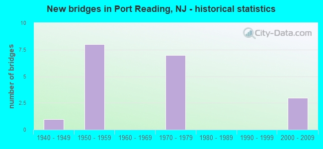
- New bridges - historical statistics
- 11940-1949
- 81950-1959
- 71970-1979
- 32000-2009

- Reconstructed bridges - Historical Statistics
- 31980-1989
- 11990-1999
- 02000-2009
- 12010-2019


- Bridge Condition - Deck
- 14.3%Very good
- 14.3%Good
- 57.1%Satisfactory
- 14.3%Fair

- Bridge Condition - Superstructure
- 10.0%Very good
- 20.0%Good
- 30.0%Satisfactory
- 40.0%Fair

- Bridge Condition - Substructure
- 10.0%Very good
- 30.0%Good
- 20.0%Satisfactory
- 40.0%Fair
Find on map >> Show street view
Structure Number: 121B515, Location: 0.81 miles east of CR 604 (Lat: 40.564789, Lng: -74.232069), Route carried "on" structure: City street , Year Built: 2008, Status: Open, Structure Length: 1.16m (3.81ft), Average Daily Traffic: 583 (year 2021), Truck Traffic: 1%, Average Future Daily Traffic: 712 (year 2041), Design Load: HS 25 or greater, Features Intersected: TRIBUTARY OF ARTHUR KILL, Facility Carried by Structure: PROLOGIS WAY
Minimum Vertical Clearance: 30.45m (99.90ft), Kilometerpoint: 1.304, Lanes on structure: 2, Owner: County Highway Agency, Approaching Roadway Width: 12.2m (40.0ft), Skew: 4 degrees, Material/Design: Concrete, Design/Construction: Arch - Deck, Number Of Spans In Main Unit: 1, Length of Maximum Span: 11.6m (38.1ft), Curb or Sidewalk Widths: Left: 1.2m (3.9ft), Right: 0.0m, Curb-To-Curb Width: 12.2m (40.0ft), Out-to-Out Width: 42.7m (140.1ft)
Condition: Superstructure: Good, Substructure: Very good, Channel: Very good, Operating Rating: 59.0 metric tons, Method Used To Determine Operating Rating: Load Factor (LF), Inventory Rating: 35.4 metric tons, Method Used To Determine Inventory Rating: Load Factor (LF), Structural Evaluation: Better than present minimum criteria, Deck Geometry: Equal to present desirable criteria, Waterway Adequacy: Equal to present desirable criteria, Approach Roadway Alignment: Equal to present desirable criteria, Designated Inspection Frequency: Every 24 months, Inspection Date: May 2021
Find on map >> Show street view
Structure Number: 121B516, Location: 1.07 miles east of CR 604 (Lat: 40.564039, Lng: -74.227550), Route carried "on" structure: City street , Year Built: 2008, Status: Open, Structure Length: 1.10m (3.61ft), Average Daily Traffic: 583 (year 2021), Truck Traffic: 1%, Average Future Daily Traffic: 712 (year 2041), Design Load: HS 25 or greater, Features Intersected: TRIBUTARY OF ARTHUR KILL, Facility Carried by Structure: PROLOGIS WAY
Minimum Vertical Clearance: 30+ m (98+ ft), Kilometerpoint: 1.722, Lanes on structure: 2, Owner: County Highway Agency, Approaching Roadway Width: 12.2m (40.0ft), Material/Design: Concrete, Design/Construction: Arch - Deck, Number Of Spans In Main Unit: 1, Length of Maximum Span: 11.0m (36.1ft), Curb or Sidewalk Widths: Left: 1.2m (3.9ft), Right: 0.0m, Curb-To-Curb Width: 12.2m (40.0ft), Out-to-Out Width: 32.3m (106.0ft)
Condition: Superstructure: Good, Substructure: Good, Channel: Very good, Inventory Rating: 72.6 metric tons, Method Used To Determine Inventory Rating: Load Factor (LF), Structural Evaluation: Better than present minimum criteria, Deck Geometry: Equal to present desirable criteria, Waterway Adequacy: Equal to present desirable criteria, Approach Roadway Alignment: Equal to present desirable criteria, Designated Inspection Frequency: Every 24 months, Inspection Date: May 2021
Find on map >> Show street view
Structure Number: 121B517, Location: 0.05 miles east of CR 604 (Lat: 40.568319, Lng: -74.244511), Route carried "on" structure: City street , Year Built: 2008, Status: Open, Structure Length: 0.79m (2.59ft), Average Daily Traffic: 583 (year 2021), Truck Traffic: 1%, Average Future Daily Traffic: 712 (year 2041), Design Load: HS 25 or greater, Features Intersected: TRIBUTARY OF ARTHUR KILL, Facility Carried by Structure: PROLOGIS WAY
Minimum Vertical Clearance: 30+ m (98+ ft), Kilometerpoint: 0.080, Lanes on structure: 2, Owner: County Highway Agency, Approaching Roadway Width: 12.2m (40.0ft), Skew: 2 degrees, Material/Design: Concrete, Design/Construction: Frame, Number Of Spans In Main Unit: 1, Length of Maximum Span: 7.9m (25.9ft), Curb or Sidewalk Widths: Left: 1.2m (3.9ft), Right: 0.0m, Curb-To-Curb Width: 12.2m (40.0ft), Out-to-Out Width: 24.2m (79.4ft)
Condition: Superstructure: Very good, Substructure: Good, Channel: Very good, Operating Rating: 65.3 metric tons, Method Used To Determine Operating Rating: Load Factor (LF), Inventory Rating: 39.0 metric tons, Method Used To Determine Inventory Rating: Load Factor (LF), Structural Evaluation: Better than present minimum criteria, Deck Geometry: Equal to present desirable criteria, Waterway Adequacy: Equal to present desirable criteria, Approach Roadway Alignment: Equal to present desirable criteria, Designated Inspection Frequency: Every 24 months, Inspection Date: May 2021
Find on map >> Show street view
Structure Number: 1250161, Location: 2.0MI S of NJTPK Exit 12 (Lat: 40.566650, Lng: -74.250600), Route carried "on" structure: County highway 604, Year Built: 1959, Status: Open, Structure Length: 8.56m (28.08ft), Average Daily Traffic: 18,846 (year 2021), Truck Traffic: 4%, Average Future Daily Traffic: 22,996 (year 2041), Design Load: HS 20, Features Intersected: CHEMICAL COAST SECONDARY
Minimum Vertical Clearance: 30+ m (98+ ft), Kilometerpoint: 13.036, Lanes on structure: 2, Lanes under structure: 2, Maintenance Responsibility: State Highway Agency, Approaching Roadway Width: 12.2m (40.0ft), Skew: 4 degrees, Material/Design: Steel continuous, Design/Construction: Stringer/Multi-beam, Number Of Spans In Main Unit: 3, Length of Maximum Span: 32.3m (106.0ft), Curb or Sidewalk Widths: Left: 1.5m (4.9ft), Right: 1.5m (4.9ft), Curb-To-Curb Width: 12.2m (40.0ft), Out-to-Out Width: 16.0m (52.5ft)
Condition: Deck: Satisfactory, Superstructure: Satisfactory, Substructure: Fair, Operating Rating: 69.9 metric tons, Method Used To Determine Operating Rating: Load Factor (LF), Inventory Rating: 41.7 metric tons, Method Used To Determine Inventory Rating: Load Factor (LF), Structural Evaluation: Somewhat better than minimum adequacy, Deck Geometry: Somewhat better than minimum adequacy, Underclear: Equal to present minimum criteria, Approach Roadway Alignment: Better than present minimum criteria, Designated Inspection Frequency: Every 24 months, Inspection Date: September 2021, Deck Structure Type: Concrete Cast-file-Place, Wearing Surface/Protective System: Wearing Surface: Monolithic Concrete
Find on map >> Show street view
Structure Number: 1252163, Location: 2.0MI S of NJTPK Exit 12 (Lat: 40.567411, Lng: -74.248339), Route carried "on" structure: County highway 604, Year Built: 1958, Status: Open, Structure Length: 5.00m (16.40ft), Average Daily Traffic: 18,846 (year 2021), Truck Traffic: 4%, Average Future Daily Traffic: 22,996 (year 2041), Design Load: HS 20, Features Intersected: PORT READING SECONDARY
Minimum Vertical Clearance: 30+ m (98+ ft), Kilometerpoint: 13.213, Lanes on structure: 2, Lanes under structure: 2, Maintenance Responsibility: State Highway Agency, Approaching Roadway Width: 12.2m (40.0ft), Skew: 3 degrees, Material/Design: Steel continuous, Design/Construction: Stringer/Multi-beam, Number Of Spans In Main Unit: 3, Length of Maximum Span: 20.1m (65.9ft), Curb or Sidewalk Widths: Left: 1.5m (4.9ft), Right: 1.5m (4.9ft), Curb-To-Curb Width: 12.2m (40.0ft), Out-to-Out Width: 16.0m (52.5ft)
Condition: Deck: Fair, Superstructure: Satisfactory, Substructure: Fair, Operating Rating: 63.5 metric tons, Method Used To Determine Operating Rating: Load Factor (LF), Inventory Rating: 38.1 metric tons, Method Used To Determine Inventory Rating: Load Factor (LF), Structural Evaluation: Somewhat better than minimum adequacy, Deck Geometry: Somewhat better than minimum adequacy, Underclear: High priority of corrective action, Approach Roadway Alignment: Equal to present minimum criteria, Length Of Structure Improvement: 5.00m (16.40ft), Designated Inspection Frequency: Every 24 months, Inspection Date: September 2021, Total Project Cost: $14,000 ( Estimate for 2021), Deck Structure Type: Concrete Cast-file-Place, Wearing Surface/Protective System: Wearing Surface: Monolithic Concrete
Find on map >> Show street view
Structure Number: M09327, Location: 0.4 MI N SA 10S & 10N (Lat: 40.563333, Lng: -74.261667), Route carried "on" structure: County highway 604, Year Built: 1970, Year Reconstructed: 1990, Status: Open, Structure Length: 15.36m (50.39ft), Average Daily Traffic: 18,003 (year 2021), Truck Traffic: 4%, Average Future Daily Traffic: 21,968 (year 2041), Features Intersected: NJ TURNPIKE, Facility Carried by Structure: PORT READING AVE.
Minimum Vertical Clearance: 30+ m (98+ ft), Kilometerpoint: 12.038, Lanes on structure: 2, Lanes under structure: 19, Owner: State Toll Authority, Approaching Roadway Width: 12.2m (40.0ft), Skew: 3 degrees, Material/Design: Steel, Design/Construction: Stringer/Multi-beam, Number Of Spans In Main Unit: 5, Length of Maximum Span: 41.5m (136.2ft), Curb or Sidewalk Widths: Left: 1.8m (5.9ft), Right: 1.8m (5.9ft), Curb-To-Curb Width: 12.2m (40.0ft), Out-to-Out Width: 16.5m (54.1ft)
Condition: Deck: Satisfactory, Superstructure: Satisfactory, Substructure: Satisfactory, Operating Rating: 43.4 metric tons, Method Used To Determine Operating Rating: Load and Resistance Factor Rating (LRFR) rating reported by rating factor(RF) method using HL-93 loadings, Inventory Rating: 33.4 metric tons, Method Used To Determine Inventory Rating: Load and Resistance Factor Rating (LRFR) rating reported by rating factor(RF) method using HL-93 loadings, Structural Evaluation: Equal to present minimum criteria, Deck Geometry: Somewhat better than minimum adequacy, Underclear: High priority of corrective action, Approach Roadway Alignment: Equal to present desirable criteria, Length Of Structure Improvement: 15.36m (50.39ft), Designated Inspection Frequency: Every 24 months, Inspection Date: May 2021, Bridge Improvement Cost: $153,000, Roadway Improvement Cost: $51,000, Total Project Cost: $306,000 ( Estimate for 2017), Deck Structure Type: Concrete Cast-file-Place, Wearing Surface/Protective System: Wearing Surface: Latex Concrete
Find on map >> Show street view
Structure Number: M09381N, Location: .9 MI N WOODBRIDGE SERV.A (Lat: 40.568333, Lng: -74.253333), Route carried "on" structure: Interstate 95, Year Built: 1950, Year Reconstructed: 2019, Status: Open, Structure Length: 4.11m (13.48ft), Average Daily Traffic: 103,955 (year 2021), Truck Traffic: 10%, Average Future Daily Traffic: 126,845 (year 2041), Design Load: H 20, Features Intersected: PORT READING RR & 94UTRN, Facility Carried by Structure: NJTPK SNI ROADWAY
Minimum Vertical Clearance: 30+ m (98+ ft), Kilometerpoint: 78.005, Lanes on structure: 3, Lanes under structure: 2, Base Highway Network: Yes, Toll: On toll road, Owner: State Toll Authority, Approaching Roadway Width: 16.9m (55.4ft), Skew: 2 degrees, Material/Design: Steel, Design/Construction: Stringer/Multi-beam, Number Of Spans In Main Unit: 3, Length of Maximum Span: 14.6m (47.9ft), Curb-To-Curb Width: 17.0m (55.8ft), Out-to-Out Width: 17.7m (58.1ft)
Condition: Deck: Very good, Superstructure: Fair, Substructure: Good, Operating Rating: 56.7 metric tons, Method Used To Determine Operating Rating: Load and Resistance Factor Rating (LRFR) rating reported by rating factor(RF) method using HL-93 loadings, Inventory Rating: 43.7 metric tons, Method Used To Determine Inventory Rating: Load and Resistance Factor Rating (LRFR) rating reported by rating factor(RF) method using HL-93 loadings, Structural Evaluation: Somewhat better than minimum adequacy, Deck Geometry: Equal to present minimum criteria, Underclear: High priority of corrective action, Approach Roadway Alignment: Equal to present desirable criteria, Length Of Structure Improvement: 4.30m (14.11ft), Designated Inspection Frequency: Every 24 months, Inspection Date: April 2021, Bridge Improvement Cost: $100,000, Roadway Improvement Cost: $50,000, Total Project Cost: $250,000, Deck Structure Type: Concrete Cast-file-Place, Wearing Surface/Protective System: Wearing Surface: Monolithic Concrete, Deck Protection: Epoxy Coated Reinforcing
Find on map >> Show street view
Structure Number: M09381S, Location: .9 MI N WOODBRIDGE SERV.A (Lat: 40.568333, Lng: -74.253333), Route carried "on" structure: Interstate 95, Year Built: 1970, Status: Open, Structure Length: 4.30m (14.11ft), Average Daily Traffic: 105,441 (year 2021), Truck Traffic: 14%, Average Future Daily Traffic: 128,760 (year 2041), Design Load: HS 20, Features Intersected: PORT READING RR & 94UTRN, Facility Carried by Structure: NJTPK NSI ROADWAY
Minimum Vertical Clearance: 30+ m (98+ ft), Kilometerpoint: 78.005, Lanes on structure: 3, Lanes under structure: 2, Base Highway Network: Yes, Toll: On toll road, Owner: State Toll Authority, Approaching Roadway Width: 21.3m (69.9ft), Skew: 2 degrees, Material/Design: Steel, Design/Construction: Stringer/Multi-beam, Number Of Spans In Main Unit: 3, Length of Maximum Span: 14.6m (47.9ft), Curb-To-Curb Width: 21.5m (70.5ft), Out-to-Out Width: 22.6m (74.1ft)
Condition: Deck: Satisfactory, Superstructure: Fair, Substructure: Fair, Operating Rating: 69.3 metric tons, Method Used To Determine Operating Rating: Load and Resistance Factor Rating (LRFR) rating reported by rating factor(RF) method using HL-93 loadings, Inventory Rating: 53.5 metric tons, Method Used To Determine Inventory Rating: Load and Resistance Factor Rating (LRFR) rating reported by rating factor(RF) method using HL-93 loadings, Structural Evaluation: Somewhat better than minimum adequacy, Deck Geometry: Superior to present desirable criteria, Underclear: High priority of corrective action, Approach Roadway Alignment: Equal to present desirable criteria, Length Of Structure Improvement: 4.30m (14.11ft), Designated Inspection Frequency: Every 24 months, Inspection Date: April 2021, Bridge Improvement Cost: $100,000, Roadway Improvement Cost: $50,000, Total Project Cost: $250,000 ( Estimate for 2017), Deck Structure Type: Concrete Cast-file-Place, Wearing Surface/Protective System: Wearing Surface: Bituminous, Membrane: Other
Find on map >> Show street view
Structure Number: M09406, Location: 1.83 Mi. South of Int. 12 (Lat: 40.571458, Lng: -74.251008), Route carried "on" structure: Interstate 95, Year Built: 1947, Year Reconstructed: 1992, Status: Open, Structure Length: 0.91m (2.99ft), Average Daily Traffic: 196,710 (year 2021), Truck Traffic: 10%, Average Future Daily Traffic: 240,024 (year 2041), Design Load: HS 20, Features Intersected: Colonial Pipelines, Facility Carried by Structure: TPKNSO/NSI/SNI/SNO
Minimum Vertical Clearance: 30+ m (98+ ft), Kilometerpoint: 78.407, Lanes on structure: 14, Base Highway Network: Yes, Toll: On toll road, Owner: State Toll Authority, Approaching Roadway Width: 83.2m (273.0ft), Skew: 30 degrees, Material/Design: Concrete, Design/Construction: Culvert, Number Of Spans In Main Unit: 3, Length of Maximum Span: 3.0m (9.8ft)
Condition: Culverts: Good, Operating Rating: 54.4 metric tons, Method Used To Determine Operating Rating: Field evaluation and documented engineering judgment, Inventory Rating: 32.7 metric tons, Method Used To Determine Inventory Rating: Field evaluation and documented engineering judgment, Structural Evaluation: Better than present minimum criteria, Approach Roadway Alignment: Equal to present desirable criteria, Designated Inspection Frequency: Every 24 months, Inspection Date: July 2021
Find on map >> Show street view
Structure Number: MN9381N, Location: 0.9 MI N WOODBRIDGE SA (Lat: 40.568333, Lng: -74.253333), Route carried "on" structure: Interstate 95, Year Built: 1970, Year Reconstructed: 1994, Status: Open, Structure Length: 4.30m (14.11ft), Average Daily Traffic: 104,591 (year 2021), Truck Traffic: 10%, Average Future Daily Traffic: 127,622 (year 2041), Design Load: HS 20, Features Intersected: PORT READING RR & 94UTRN, Facility Carried by Structure: SNO ROADWAY
Minimum Vertical Clearance: 30+ m (98+ ft), Kilometerpoint: 78.005, Lanes on structure: 4, Lanes under structure: 2, Base Highway Network: Yes, Toll: On toll road, Owner: State Toll Authority, Approaching Roadway Width: 23.8m (78.1ft), Skew: 2 degrees, Material/Design: Steel, Design/Construction: Stringer/Multi-beam, Number Of Spans In Main Unit: 3, Length of Maximum Span: 14.6m (47.9ft), Curb-To-Curb Width: 23.8m (78.1ft), Out-to-Out Width: 26.3m (86.3ft)
Condition: Deck: Satisfactory, Superstructure: Fair, Substructure: Fair, Operating Rating: 72.9 metric tons, Method Used To Determine Operating Rating: Load and Resistance Factor Rating (LRFR) rating reported by rating factor(RF) method using HL-93 loadings, Inventory Rating: 56.1 metric tons, Method Used To Determine Inventory Rating: Load and Resistance Factor Rating (LRFR) rating reported by rating factor(RF) method using HL-93 loadings, Structural Evaluation: Somewhat better than minimum adequacy, Deck Geometry: Superior to present desirable criteria, Underclear: High priority of corrective action, Approach Roadway Alignment: Equal to present desirable criteria, Length Of Structure Improvement: 4.30m (14.11ft), Designated Inspection Frequency: Every 24 months, Inspection Date: April 2021, Bridge Improvement Cost: $102,000, Roadway Improvement Cost: $5,000, Total Project Cost: $255,000 ( Estimate for 2015), Deck Structure Type: Concrete Cast-file-Place, Wearing Surface/Protective System: Wearing Surface: Bituminous, Membrane: Other
Find on map >> Show street view
Structure Number: MS9381S, Location: .9 MI N WOODBRIDGE SERV.A (Lat: 40.568333, Lng: -74.253333), Route carried "on" structure: Interstate 95, Year Built: 1950, Year Reconstructed: 1994, Status: Open, Structure Length: 4.30m (14.11ft), Average Daily Traffic: 104,591 (year 2021), Truck Traffic: 10%, Average Future Daily Traffic: 127,622 (year 2041), Design Load: H 20, Features Intersected: PORT READING RR & 94UTRN, Facility Carried by Structure: NJTPK NSO ROADWAY
Minimum Vertical Clearance: 30+ m (98+ ft), Kilometerpoint: 78.005, Lanes on structure: 4, Lanes under structure: 2, Base Highway Network: Yes, Toll: On toll road, Owner: State Toll Authority, Approaching Roadway Width: 23.8m (78.1ft), Skew: 2 degrees, Material/Design: Steel, Design/Construction: Stringer/Multi-beam, Number Of Spans In Main Unit: 3, Length of Maximum Span: 14.6m (47.9ft), Curb-To-Curb Width: 23.7m (77.8ft), Out-to-Out Width: 24.4m (80.1ft)
Condition: Deck: Good, Superstructure: Fair, Substructure: Satisfactory, Operating Rating: 48.3 metric tons, Method Used To Determine Operating Rating: Load and Resistance Factor Rating (LRFR) rating reported by rating factor(RF) method using HL-93 loadings, Inventory Rating: 37.3 metric tons, Method Used To Determine Inventory Rating: Load and Resistance Factor Rating (LRFR) rating reported by rating factor(RF) method using HL-93 loadings, Structural Evaluation: Somewhat better than minimum adequacy, Deck Geometry: Superior to present desirable criteria, Underclear: High priority of corrective action, Approach Roadway Alignment: Equal to present desirable criteria, Length Of Structure Improvement: 4.30m (14.11ft), Designated Inspection Frequency: Every 24 months, Inspection Date: April 2021, Bridge Improvement Cost: $200,000, Roadway Improvement Cost: $50,000, Total Project Cost: $300,000 ( Estimate for 2017), Deck Structure Type: Concrete Cast-file-Place, Wearing Surface/Protective System: Wearing Surface: Bituminous
Find on map >> Show street view
Structure Number: 1250161, Location: 2.0MI S of NJTPK Exit 12 (Lat: 40.566650, Lng: -74.250600), Route carried "under" structure: ServiceOther road , Year Built: 1959, Structure Length: 0. m, Average Daily Traffic: 18 (year 2021), Features Intersected: CHEMICAL COAST SECONDARY, Facility Carried by Structure: PORT RDNG AV-CR604
Minimum Vertical Clearance: 6.30m (20.67ft), Kilometerpoint: 0.000, Lanes on structure: 2, Lanes under structure: 2, Material/Design: Steel continuous, Design/Construction: Stringer/Multi-beam, Length of Maximum Span: 32.3m (106.0ft)
Find on map >> Show street view
Structure Number: 1252163, Location: 2.0MI S of NJTPK Exit 12 (Lat: 40.567411, Lng: -74.248339), Route carried "under" structure: City street , Year Built: 1958, Structure Length: 0. m, Average Daily Traffic: 17 (year 2021), Features Intersected: PORT READING SECONDARY, Facility Carried by Structure: PORT RDG AVE-CR604
Minimum Vertical Clearance: 6.96m (22.83ft), Kilometerpoint: 0.000, Lanes on structure: 2, Lanes under structure: 2, Material/Design: Steel continuous, Design/Construction: Stringer/Multi-beam, Length of Maximum Span: 20.1m (65.9ft)
Find on map >> Show street view
Structure Number: M09327, Location: 0.4 MI N SA 10S & 10N (Lat: 40.563333, Lng: -74.261667), Route carried "under" structure: Interstate 604, Year Built: 1970, Structure Length: 0. m, Average Daily Traffic: 974 (year 2021), Truck Traffic: 4%, Features Intersected: NJ TURNPIKE, Facility Carried by Structure: PORT READING AVE.
Minimum Vertical Clearance: 4.60m (15.09ft), Kilometerpoint: 12.038, Lanes on structure: 2, Lanes under structure: 1, Material/Design: Steel, Design/Construction: Stringer/Multi-beam, Length of Maximum Span: 41.5m (136.2ft)
Find on map >> Show street view
Structure Number: M09327, Location: 0.4 MI N SA 10S & 10N (Lat: 40.563333, Lng: -74.261667), Route carried "under" structure: Interstate 95, Year Built: 1970, Structure Length: 0. m, Average Daily Traffic: 91,809 (year 2021), Truck Traffic: 23%, Features Intersected: NJ TURNPIKE, Facility Carried by Structure: PORT READING AVE.
Minimum Vertical Clearance: 4.80m (15.75ft), Kilometerpoint: 77.120, Lanes on structure: 2, Lanes under structure: 18, Toll: On toll road, Material/Design: Steel, Design/Construction: Stringer/Multi-beam, Length of Maximum Span: 41.5m (136.2ft)
Find on map >> Show street view
Structure Number: M09381N, Location: .9 MI N WOODBRIDGE SERV.A (Lat: 40.568333, Lng: -74.253333), Route carried "under" structure: Ramp Interstate 95, Year Built: 1950, Structure Length: 0. m, Average Daily Traffic: 1,548 (year 2021), Truck Traffic: 9%, Features Intersected: PORT READING RR & 94UTRN, Facility Carried by Structure: NJTPK SNI ROADWAY
Minimum Vertical Clearance: 5.03m (16.50ft), Kilometerpoint: 78.214, Lanes on structure: 3, Lanes under structure: 2, Toll: On toll road, Material/Design: Steel, Design/Construction: Stringer/Multi-beam, Length of Maximum Span: 14.6m (47.9ft)
Find on map >> Show street view
Structure Number: M09381S, Location: .9 MI N WOODBRIDGE SERV.A (Lat: 40.568333, Lng: -74.253333), Route carried "under" structure: Ramp Interstate 95, Year Built: 1970, Structure Length: 0. m, Average Daily Traffic: 1,548 (year 2021), Truck Traffic: 4%, Features Intersected: PORT READING RR & 94UTRN, Facility Carried by Structure: NJTPK NSI ROADWAY
Minimum Vertical Clearance: 4.67m (15.32ft), Kilometerpoint: 78.214, Lanes on structure: 3, Lanes under structure: 2, Toll: On toll road, Material/Design: Steel, Design/Construction: Stringer/Multi-beam, Length of Maximum Span: 14.6m (47.9ft)
Find on map >> Show street view
Structure Number: MN9381N, Location: 0.9 MI N WOODBRIDGE SA (Lat: 40.568333, Lng: -74.253333), Route carried "under" structure: Ramp Interstate 95, Year Built: 1970, Structure Length: 0. m, Average Daily Traffic: 1,548 (year 2021), Truck Traffic: 1%, Features Intersected: PORT READING RR & 94UTRN, Facility Carried by Structure: SNO ROADWAY
Minimum Vertical Clearance: 5.03m (16.50ft), Kilometerpoint: 78.005, Lanes on structure: 4, Lanes under structure: 2, Toll: On toll road, Material/Design: Steel, Design/Construction: Stringer/Multi-beam, Length of Maximum Span: 14.6m (47.9ft)
Find on map >> Show street view
Structure Number: MS9381S, Location: .9 MI N WOODBRIDGE SERV.A (Lat: 40.568333, Lng: -74.253333), Route carried "under" structure: Ramp Interstate , Year Built: 1950, Structure Length: 0. m, Average Daily Traffic: 1,548 (year 2021), Truck Traffic: 1%, Features Intersected: PORT READING RR & 94UTRN, Facility Carried by Structure: NJTPK NSO ROADWAY
Minimum Vertical Clearance: 4.65m (15.26ft), Kilometerpoint: 78.005, Lanes on structure: 4, Lanes under structure: 2, Toll: On toll road, Material/Design: Steel, Design/Construction: Stringer/Multi-beam, Length of Maximum Span: 14.6m (47.9ft)