Bridge Statistics for Portsmouth, Rhode Island (RI)
Condition, Traffic, Stress, Structural Evaluation, Project Costs
- National Bridge Inventory (NBI) Statistics
- 13Number of bridges
- 387ft / 118mTotal length
- $25,112,000Total costs
- 229,164Total average daily traffic
- 13,354Total average daily truck traffic
- National Bridge Inventory (NBI) Registered Bridges for Portsmouth
- No street view available for this location
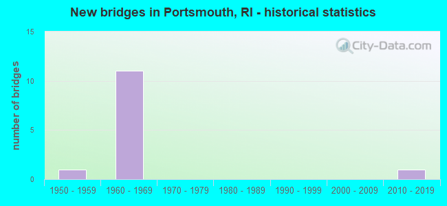
- New bridges - historical statistics
- 11950-1959
- 111960-1969
- 12010-2019


- Bridge Condition - Deck
- 50.0%Good
- 50.0%Satisfactory

- Bridge Condition - Superstructure
- 18.2%Good
- 36.4%Satisfactory
- 45.5%Fair

- Bridge Condition - Substructure
- 36.4%Good
- 63.6%Satisfactory

- Bridge Condition - Channel
- 50.0%Very good
- 50.0%Satisfactory
Find on map >> Show street view
Structure Number: 121, Location: 1.0 Mi N of JCT RI 114 (Lat: 41.638172, Lng: -71.221225), Route carried "on" structure: State highway 24, Year Built: 1956, Year Reconstructed: 1989, Status: Open, Structure Length: 2.13m (6.99ft), Average Daily Traffic: 32,400 (year 2021), Truck Traffic: 4%, Average Future Daily Traffic: 35,640 (year 2041), Design Load: HS 20, Features Intersected: HUMMOCKS AV
Minimum Vertical Clearance: 30+ m (98+ ft), Kilometerpoint: 5.993, Lanes on structure: 5, Lanes under structure: 2, Base Highway Network: Yes, Owner: State Toll Authority, Approaching Roadway Width: 24.4m (80.1ft), Skew: 35 degrees, Material/Design: Concrete, Design/Construction: Frame, Number Of Spans In Main Unit: 1, Length of Maximum Span: 18.9m (62.0ft), Curb or Sidewalk Widths: Left: 0.9m (3.0ft), Right: 0.0m, Curb-To-Curb Width: 24.4m (80.1ft), Out-to-Out Width: 27.4m (89.9ft)
Condition: Deck: Satisfactory, Superstructure: Satisfactory, Substructure: Satisfactory, Operating Rating: 72.5 metric tons, Method Used To Determine Operating Rating: Load and Resistance Factor (LRFR), Inventory Rating: 55.9 metric tons, Method Used To Determine Inventory Rating: Load and Resistance Factor (LRFR), Structural Evaluation: Equal to present minimum criteria, Deck Geometry: Equal to present minimum criteria, Underclear: High priority of corrective action, Approach Roadway Alignment: Equal to present desirable criteria, Length Of Structure Improvement: 2.13m (6.99ft), Designated Inspection Frequency: Every 24 months, Inspection Date: April 2021, Bridge Improvement Cost: $1,559,000, Roadway Improvement Cost: $156,000, Total Project Cost: $2,338,000, Deck Structure Type: Concrete Cast-file-Place, Wearing Surface/Protective System: Wearing Surface: Bituminous, Membrane: Other
Find on map >> Show street view
Structure Number: 2505, Location: 0.1 Mi S of JCT RI 138 (Lat: 41.638103, Lng: -71.213353), Route carried "on" structure: State highway 24, Year Built: 2012, Status: Open, Structure Length: 69.04m (226.51ft), Average Daily Traffic: 40,000 (year 2008), Truck Traffic: 3%, Average Future Daily Traffic: 48,000 (year 2036), Design Load: HL 93, Features Intersected: SAKONNET RIVER
Minimum Vertical Clearance: 30+ m (98+ ft), Kilometerpoint: 6.651, Lanes on structure: 4, Lanes under structure: 6, Base Highway Network: Yes, Owner: State Toll Authority, Approaching Roadway Width: 23.2m (76.1ft), Skew: 30 degrees, Material/Design: Steel continuous, Design/Construction: Stringer/Multi-beam, Number Of Spans In Main Unit: 7, Number Of Approach Spans: 3, Length of Maximum Span: 121.9m (399.9ft), Curb-To-Curb Width: 23.2m (76.1ft), Out-to-Out Width: 28.7m (94.2ft)
Condition: Deck: Good, Superstructure: Good, Substructure: Good, Channel: Very good, Operating Rating: 53.3 metric tons, Method Used To Determine Operating Rating: Load and Resistance Factor (LRFR), Inventory Rating: 41.0 metric tons, Method Used To Determine Inventory Rating: Load and Resistance Factor (LRFR), Structural Evaluation: Better than present minimum criteria, Deck Geometry: Superior to present desirable criteria, Underclear: Meets minimum limits, Waterway Adequacy: Superior to present desirable criteria, Approach Roadway Alignment: Equal to present desirable criteria, Designated Inspection Frequency: Every 24 months, Underwater Inspection Frequency: Every 60 months, Inspection Date: August 2020, Underwater Inspection Date: August 2021, Deck Structure Type: Concrete Cast-file-Place, Wearing Surface/Protective System: Wearing Surface: Bituminous, Membrane: Epoxy, Deck Protection: Galvanized Reinforcing
Find on map >> Show street view
Structure Number: 495, Location: 0.5 Mi S of RI 24 (Lat: 41.629911, Lng: -71.219078), Route carried "on" structure: Other road , Year Built: 1961, Status: Open, Structure Length: 9.60m (31.50ft), Average Daily Traffic: 2,599 (year 2021), Truck Traffic: 5%, Average Future Daily Traffic: 2,859 (year 2041), Design Load: HL 93, Features Intersected: TIDAL INLET, Facility Carried by Structure: HUMMOCKS POINT RD
Minimum Vertical Clearance: 30+ m (98+ ft), Kilometerpoint: 2.765, Lanes on structure: 2, Owner: State Highway Agency, Approaching Roadway Width: 11.7m (38.4ft), Skew: 1 degrees, Material/Design: Prestressed concrete, Design/Construction: Box Beam or Girders - Multiple, Number Of Spans In Main Unit: 9, Length of Maximum Span: 10.7m (35.1ft), Curb or Sidewalk Widths: Left: 1.5m (4.9ft), Right: 1.5m (4.9ft), Curb-To-Curb Width: 9.2m (30.2ft), Out-to-Out Width: 12.9m (42.3ft)
Condition: Superstructure: Good, Substructure: Satisfactory, Channel: Satisfactory, Operating Rating: 35.3 metric tons, Method Used To Determine Operating Rating: Load and Resistance Factor Rating (LRFR) rating reported by rating factor(RF) method using HL-93 loadings, Inventory Rating: 27.2 metric tons, Method Used To Determine Inventory Rating: Load and Resistance Factor Rating (LRFR) rating reported by rating factor(RF) method using HL-93 loadings, Structural Evaluation: Equal to present minimum criteria, Deck Geometry: Meets minimum limits, Waterway Adequacy: Superior to present desirable criteria, Approach Roadway Alignment: Better than present minimum criteria, Length Of Structure Improvement: 9.60m (31.50ft), Designated Inspection Frequency: Every 24 months, Underwater Inspection Frequency: Every 48 months, Inspection Date: July 2020, Underwater Inspection Date: August 2018, Bridge Improvement Cost: $2,576,000, Roadway Improvement Cost: $258,000, Total Project Cost: $3,864,000
Find on map >> Show street view
Structure Number: 642, Location: 2.0 Mi N of JCT RI 114 (Lat: 41.628389, Lng: -71.243997), Route carried "on" structure: State highway 24, Year Built: 1964, Year Reconstructed: 1989, Status: Open, Structure Length: 4.45m (14.60ft), Average Daily Traffic: 19,516 (year 2015), Truck Traffic: 2%, Average Future Daily Traffic: 23,420 (year 2036), Design Load: HS 20+Mod, Features Intersected: BOYDS LANE
Minimum Vertical Clearance: 30+ m (98+ ft), Kilometerpoint: 3.574, Lanes on structure: 2, Lanes under structure: 2, Base Highway Network: Yes, Owner: State Highway Agency, Approaching Roadway Width: 12.2m (40.0ft), Skew: 12 degrees, Material/Design: Steel continuous, Design/Construction: Stringer/Multi-beam, Number Of Spans In Main Unit: 3, Length of Maximum Span: 20.4m (66.9ft), Curb-To-Curb Width: 12.2m (40.0ft), Out-to-Out Width: 13.4m (44.0ft)
Condition: Deck: Satisfactory, Superstructure: Fair, Substructure: Good, Operating Rating: 39.5 metric tons, Method Used To Determine Operating Rating: Load and Resistance Factor Rating (LRFR) rating reported by rating factor(RF) method using HL-93 loadings, Inventory Rating: 30.5 metric tons, Method Used To Determine Inventory Rating: Load and Resistance Factor Rating (LRFR) rating reported by rating factor(RF) method using HL-93 loadings, Structural Evaluation: Somewhat better than minimum adequacy, Deck Geometry: Better than present minimum criteria, Underclear: Somewhat better than minimum adequacy, Approach Roadway Alignment: Equal to present desirable criteria, Length Of Structure Improvement: 4.45m (14.60ft), Designated Inspection Frequency: Every 24 months, Inspection Date: December 2020, Bridge Improvement Cost: $28,000, Total Project Cost: $43,000, Deck Structure Type: Concrete Cast-file-Place, Wearing Surface/Protective System: Wearing Surface: Bituminous, Membrane: Built-up
Find on map >> Show street view
Structure Number: 6422, Location: 2.0 Mi N of JCT RI 114 (Lat: 41.628561, Lng: -71.244117), Route carried "on" structure: State highway 24, Year Built: 1964, Year Reconstructed: 1989, Status: Open, Structure Length: 4.45m (14.60ft), Average Daily Traffic: 19,516 (year 2007), Truck Traffic: 10%, Average Future Daily Traffic: 23,420 (year 2036), Design Load: HS 20+Mod, Features Intersected: BOYDS LANE
Minimum Vertical Clearance: 30+ m (98+ ft), Kilometerpoint: 9.151, Lanes on structure: 2, Lanes under structure: 2, Base Highway Network: Yes, Owner: State Highway Agency, Approaching Roadway Width: 12.2m (40.0ft), Skew: 12 degrees, Material/Design: Steel continuous, Design/Construction: Stringer/Multi-beam, Number Of Spans In Main Unit: 3, Length of Maximum Span: 20.4m (66.9ft), Curb-To-Curb Width: 12.2m (40.0ft), Out-to-Out Width: 13.4m (44.0ft)
Condition: Deck: Good, Superstructure: Fair, Substructure: Good, Operating Rating: 42.8 metric tons, Method Used To Determine Operating Rating: Load and Resistance Factor Rating (LRFR) rating reported by rating factor(RF) method using HL-93 loadings, Inventory Rating: 33.0 metric tons, Method Used To Determine Inventory Rating: Load and Resistance Factor Rating (LRFR) rating reported by rating factor(RF) method using HL-93 loadings, Structural Evaluation: Somewhat better than minimum adequacy, Deck Geometry: Better than present minimum criteria, Underclear: Somewhat better than minimum adequacy, Approach Roadway Alignment: Equal to present desirable criteria, Length Of Structure Improvement: 4.45m (14.60ft), Designated Inspection Frequency: Every 24 months, Inspection Date: December 2020, Bridge Improvement Cost: $1,847,000, Roadway Improvement Cost: $185,000, Total Project Cost: $2,771,000, Deck Structure Type: Concrete Cast-file-Place, Wearing Surface/Protective System: Wearing Surface: Bituminous, Membrane: Built-up
Find on map >> Show street view
Structure Number: 644, Location: 0.5 Mi W of JCT RI 138 (Lat: 41.616614, Lng: -71.252653), Route carried "on" structure: City street , Year Built: 1964, Year Reconstructed: 1991, Status: Open, Structure Length: 5.33m (17.49ft), Average Daily Traffic: 3,969 (year 2015), Truck Traffic: 10%, Average Future Daily Traffic: 4,763 (year 2036), Design Load: HS 20, Features Intersected: RI 24, Facility Carried by Structure: SPRAGUE ST
Minimum Vertical Clearance: 30+ m (98+ ft), Kilometerpoint: 0.357, Lanes on structure: 2, Lanes under structure: 4, Owner: State Highway Agency, Approaching Roadway Width: 8.5m (27.9ft), Skew: 4 degrees, Material/Design: Steel, Design/Construction: Stringer/Multi-beam, Number Of Spans In Main Unit: 2, Length of Maximum Span: 26.4m (86.6ft), Curb or Sidewalk Widths: Left: 1.5m (4.9ft), Right: 1.5m (4.9ft), Curb-To-Curb Width: 8.5m (27.9ft), Out-to-Out Width: 12.3m (40.4ft)
Condition: Deck: Satisfactory, Superstructure: Satisfactory, Substructure: Good, Operating Rating: 67.7 metric tons, Method Used To Determine Operating Rating: Load and Resistance Factor Rating (LRFR) rating reported by rating factor(RF) method using HL-93 loadings, Inventory Rating: 52.2 metric tons, Method Used To Determine Inventory Rating: Load and Resistance Factor Rating (LRFR) rating reported by rating factor(RF) method using HL-93 loadings, Structural Evaluation: Equal to present minimum criteria, Deck Geometry: Meets minimum limits, Underclear: Somewhat better than minimum adequacy, Approach Roadway Alignment: Somewhat better than minimum adequacy, Length Of Structure Improvement: 5.24m (17.19ft), Designated Inspection Frequency: Every 24 months, Inspection Date: October 2020, Bridge Improvement Cost: $2,066,000, Roadway Improvement Cost: $207,000, Total Project Cost: $3,099,000, Deck Structure Type: Concrete Cast-file-Place, Wearing Surface/Protective System: Wearing Surface: Bituminous, Membrane: Built-up
Find on map >> Show street view
Structure Number: 645, Location: 0.8 Mi N of JCT RI 114 (Lat: 41.610472, Lng: -71.254289), Route carried "on" structure: State highway 24, Year Built: 1964, Year Reconstructed: 1991, Status: Open, Structure Length: 7.01m (23.00ft), Average Daily Traffic: 19,516 (year 2015), Truck Traffic: 2%, Average Future Daily Traffic: 23,420 (year 2036), Design Load: H 20, Features Intersected: TURNPIKE AV
Minimum Vertical Clearance: 30+ m (98+ ft), Kilometerpoint: 1.571, Lanes on structure: 2, Lanes under structure: 4, Base Highway Network: Yes, Owner: State Highway Agency, Approaching Roadway Width: 11.3m (37.1ft), Skew: 5 degrees, Material/Design: Steel continuous, Design/Construction: Stringer/Multi-beam, Number Of Spans In Main Unit: 3, Length of Maximum Span: 38.1m (125.0ft), Curb-To-Curb Width: 11.3m (37.1ft), Out-to-Out Width: 13.3m (43.6ft)
Condition: Deck: Good, Superstructure: Satisfactory, Substructure: Satisfactory, Operating Rating: 42.4 metric tons, Method Used To Determine Operating Rating: Load and Resistance Factor Rating (LRFR) rating reported by rating factor(RF) method using HL-93 loadings, Inventory Rating: 32.7 metric tons, Method Used To Determine Inventory Rating: Load and Resistance Factor Rating (LRFR) rating reported by rating factor(RF) method using HL-93 loadings, Structural Evaluation: Equal to present minimum criteria, Deck Geometry: Somewhat better than minimum adequacy, Underclear: Better than present minimum criteria, Approach Roadway Alignment: Equal to present desirable criteria, Length Of Structure Improvement: 8.08m (26.51ft), Designated Inspection Frequency: Every 24 months, Inspection Date: December 2020, Bridge Improvement Cost: $3,355,000, Roadway Improvement Cost: $335,000, Total Project Cost: $5,032,000, Deck Structure Type: Concrete Cast-file-Place, Wearing Surface/Protective System: Wearing Surface: Bituminous, Membrane: Built-up
Find on map >> Show street view
Structure Number: 6452, Location: 0.8 Mi N of JCT RI 114 (Lat: 41.610808, Lng: -71.254453), Route carried "on" structure: State highway 24, Year Built: 1964, Year Reconstructed: 1991, Status: Open, Structure Length: 7.01m (23.00ft), Average Daily Traffic: 19,516 (year 2007), Truck Traffic: 10%, Average Future Daily Traffic: 23,420 (year 2036), Design Load: HS 20+Mod, Features Intersected: TURNPIKE AV
Minimum Vertical Clearance: 30+ m (98+ ft), Kilometerpoint: 11.151, Lanes on structure: 2, Lanes under structure: 4, Base Highway Network: Yes, Owner: State Highway Agency, Approaching Roadway Width: 11.3m (37.1ft), Skew: 5 degrees, Material/Design: Steel continuous, Design/Construction: Stringer/Multi-beam, Number Of Spans In Main Unit: 3, Length of Maximum Span: 38.1m (125.0ft), Curb-To-Curb Width: 11.3m (37.1ft), Out-to-Out Width: 13.3m (43.6ft)
Condition: Deck: Satisfactory, Superstructure: Satisfactory, Substructure: Satisfactory, Operating Rating: 52.5 metric tons, Method Used To Determine Operating Rating: Load and Resistance Factor Rating (LRFR) rating reported by rating factor(RF) method using HL-93 loadings, Inventory Rating: 40.5 metric tons, Method Used To Determine Inventory Rating: Load and Resistance Factor Rating (LRFR) rating reported by rating factor(RF) method using HL-93 loadings, Structural Evaluation: Equal to present minimum criteria, Deck Geometry: Somewhat better than minimum adequacy, Underclear: Superior to present desirable criteria, Approach Roadway Alignment: Equal to present desirable criteria, Length Of Structure Improvement: 6.86m (22.51ft), Designated Inspection Frequency: Every 24 months, Inspection Date: December 2020, Bridge Improvement Cost: $2,848,000, Roadway Improvement Cost: $285,000, Total Project Cost: $4,272,000, Deck Structure Type: Concrete Cast-file-Place, Wearing Surface/Protective System: Wearing Surface: Bituminous, Membrane: Built-up
Find on map >> Show street view
Structure Number: 646, Location: 0.4 Mi N of JCT RI 114 (Lat: 41.604189, Lng: -71.256081), Route carried "on" structure: State highway 24, Year Built: 1964, Year Reconstructed: 1991, Status: Open, Structure Length: 3.38m (11.09ft), Average Daily Traffic: 19,516 (year 2015), Truck Traffic: 2%, Average Future Daily Traffic: 23,420 (year 2036), Design Load: HS 20+Mod, Features Intersected: FREEBORN ST
Minimum Vertical Clearance: 30+ m (98+ ft), Kilometerpoint: 0.950, Lanes on structure: 2, Lanes under structure: 2, Owner: State Highway Agency, Approaching Roadway Width: 12.8m (42.0ft), Skew: 1 degrees, Material/Design: Steel, Design/Construction: Stringer/Multi-beam, Number Of Spans In Main Unit: 3, Length of Maximum Span: 17.1m (56.1ft), Curb-To-Curb Width: 12.8m (42.0ft), Out-to-Out Width: 13.9m (45.6ft)
Condition: Deck: Good, Superstructure: Fair, Substructure: Satisfactory, Operating Rating: 57.3 metric tons, Method Used To Determine Operating Rating: Load and Resistance Factor Rating (LRFR) rating reported by rating factor(RF) method using HL-93 loadings, Inventory Rating: 44.1 metric tons, Method Used To Determine Inventory Rating: Load and Resistance Factor Rating (LRFR) rating reported by rating factor(RF) method using HL-93 loadings, Structural Evaluation: Somewhat better than minimum adequacy, Deck Geometry: Equal to present desirable criteria, Underclear: Meets minimum limits, Approach Roadway Alignment: Better than present minimum criteria, Length Of Structure Improvement: 3.51m (11.52ft), Designated Inspection Frequency: Every 24 months, Inspection Date: October 2020, Bridge Improvement Cost: $1,016,000, Roadway Improvement Cost: $102,000, Total Project Cost: $1,523,000, Deck Structure Type: Concrete Cast-file-Place, Wearing Surface/Protective System: Wearing Surface: Bituminous, Membrane: Built-up
Find on map >> Show street view
Structure Number: 6462, Location: 0.4 Mi N of JCT RI 114 (Lat: 41.604183, Lng: -71.256333), Route carried "on" structure: State highway 24, Year Built: 1964, Year Reconstructed: 1991, Status: Open, Structure Length: 3.57m (11.71ft), Average Daily Traffic: 19,516 (year 2008), Truck Traffic: 10%, Average Future Daily Traffic: 23,420 (year 2036), Design Load: HS 20+Mod, Features Intersected: FREEBORN ST
Minimum Vertical Clearance: 30+ m (98+ ft), Kilometerpoint: 11.792, Lanes on structure: 2, Lanes under structure: 2, Owner: State Highway Agency, Approaching Roadway Width: 12.2m (40.0ft), Skew: 1 degrees, Material/Design: Steel, Design/Construction: Stringer/Multi-beam, Number Of Spans In Main Unit: 3, Length of Maximum Span: 16.8m (55.1ft), Curb-To-Curb Width: 12.2m (40.0ft), Out-to-Out Width: 13.3m (43.6ft)
Condition: Deck: Good, Superstructure: Fair, Substructure: Satisfactory, Operating Rating: 59.6 metric tons, Method Used To Determine Operating Rating: Load and Resistance Factor Rating (LRFR) rating reported by rating factor(RF) method using HL-93 loadings, Inventory Rating: 46.0 metric tons, Method Used To Determine Inventory Rating: Load and Resistance Factor Rating (LRFR) rating reported by rating factor(RF) method using HL-93 loadings, Structural Evaluation: Somewhat better than minimum adequacy, Deck Geometry: Better than present minimum criteria, Underclear: Meets minimum limits, Approach Roadway Alignment: Better than present minimum criteria, Length Of Structure Improvement: 3.69m (12.11ft), Designated Inspection Frequency: Every 24 months, Inspection Date: October 2020, Bridge Improvement Cost: $1,022,000, Roadway Improvement Cost: $102,000, Total Project Cost: $1,533,000, Deck Structure Type: Concrete Cast-file-Place, Wearing Surface/Protective System: Wearing Surface: Bituminous, Membrane: Built-up
Find on map >> Show street view
Structure Number: 647, Location: 0.5 Mi S of JCT RI 114 (Lat: 41.602086, Lng: -71.258036), Route carried "on" structure: Ramp State highway 24, Year Built: 1964, Year Reconstructed: 1991, Status: Open, Structure Length: 2.13m (6.99ft), Average Daily Traffic: 18,100 (year 2008), Truck Traffic: 10%, Average Future Daily Traffic: 21,720 (year 2036), Features Intersected: RAMP B
Minimum Vertical Clearance: 30+ m (98+ ft), Kilometerpoint: 12.073, Lanes on structure: 1, Lanes under structure: 1, Base Highway Network: Yes, Owner: State Highway Agency, Approaching Roadway Width: 7.6m (24.9ft), Material/Design: Prestressed concrete, Design/Construction: Stringer/Multi-beam, Number Of Spans In Main Unit: 1, Length of Maximum Span: 20.1m (65.9ft), Curb or Sidewalk Widths: Left: 0.6m (2.0ft), Right: 0.6m (2.0ft), Curb-To-Curb Width: 7.6m (24.9ft), Out-to-Out Width: 9.6m (31.5ft)
Condition: Deck: Satisfactory, Superstructure: Fair, Substructure: Satisfactory, Operating Rating: 55.1 metric tons, Method Used To Determine Operating Rating: Load and Resistance Factor Rating (LRFR) rating reported by rating factor(RF) method using HL-93 loadings, Inventory Rating: 32.7 metric tons, Method Used To Determine Inventory Rating: Load and Resistance Factor Rating (LRFR) rating reported by rating factor(RF) method using HL-93 loadings, Structural Evaluation: Somewhat better than minimum adequacy, Deck Geometry: Better than present minimum criteria, Underclear: Meets minimum limits, Approach Roadway Alignment: Somewhat better than minimum adequacy, Length Of Structure Improvement: 2.13m (6.99ft), Designated Inspection Frequency: Every 24 months, Inspection Date: May 2021, Bridge Improvement Cost: $425,000, Roadway Improvement Cost: $42,000, Total Project Cost: $637,000, Deck Structure Type: Concrete Cast-file-Place, Wearing Surface/Protective System: Wearing Surface: Bituminous, Membrane: Built-up
Find on map >> Show street view
Structure Number: 644, Location: 0.5 Mi W of JCT RI 138 (Lat: 41.616614, Lng: -71.252653), Route carried "under" structure: State highway 24, Year Built: 1964, Structure Length: 0. m, Average Daily Traffic: 12,000 (year 2008), Truck Traffic: 10%, Features Intersected: RI 24, Facility Carried by Structure: SPRAGUE ST
Minimum Vertical Clearance: 4.33m (14.21ft), Kilometerpoint: 0.000, Lanes on structure: 2, Lanes under structure: 4, Material/Design: Steel, Design/Construction: Stringer/Multi-beam, Length of Maximum Span: 26.4m (86.6ft)
Find on map >> Show street view
Structure Number: 647, Location: 0.5 Mi S of JCT RI 114 (Lat: 41.602086, Lng: -71.258036), Route carried "under" structure: Ramp State highway 24, Year Built: 1964, Structure Length: 0. m, Average Daily Traffic: 3,000 (year 2008), Truck Traffic: 10%, Features Intersected: RAMP B
Minimum Vertical Clearance: 4.44m (14.57ft), Kilometerpoint: 0.000, Lanes on structure: 1, Lanes under structure: 1, Material/Design: Prestressed concrete, Design/Construction: Stringer/Multi-beam, Length of Maximum Span: 20.1m (65.9ft)