Bridge Statistics for Pottersville, New York (NY)
Condition, Traffic, Stress, Structural Evaluation, Project Costs
- National Bridge Inventory (NBI) Statistics
- 13Number of bridges
- 171ft / 51.9mTotal length
- $21,120,000Total costs
- 41,191Total average daily traffic
- 5,988Total average daily truck traffic
- National Bridge Inventory (NBI) Registered Bridges for Pottersville
- No street view available for this location
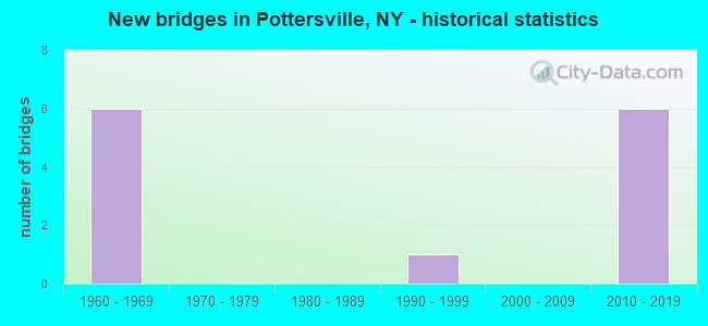
- New bridges - historical statistics
- 61960-1969
- 11990-1999
- 62010-2019


- Bridge Condition - Deck
- 14.3%Very good
- 57.1%Good
- 28.6%Satisfactory

- Bridge Condition - Superstructure
- 28.6%Excellent
- 28.6%Very good
- 42.9%Good

- Bridge Condition - Substructure
- 28.6%Excellent
- 28.6%Very good
- 42.9%Good

- Bridge Condition - Channel
- 80.0%Very good
- 20.0%Good
Find on map >> Show street view
Structure Number: 100576, Location: 0.1 MI SW JCT 9 & I87 (Lat: 43.727369, Lng: -73.824453), Route carried "on" structure: US 9, Year Built: 2016, Status: Open, Structure Length: 2.62m (8.60ft), Average Daily Traffic: 2,394 (year 2019), Truck Traffic: 10%, Average Future Daily Traffic: 2,553 (year 2040), Design Load: HL 93, Features Intersected: TROUT BROOK
Minimum Vertical Clearance: 30+ m (98+ ft), Kilometerpoint: 58.342, Lanes on structure: 2, Base Highway Network: Yes, Owner: State Highway Agency, Approaching Roadway Width: 9.1m (29.9ft), Material/Design: Steel, Design/Construction: Stringer/Multi-beam, Number Of Spans In Main Unit: 1, Length of Maximum Span: 25.3m (83.0ft), Curb-To-Curb Width: 9.1m (29.9ft), Out-to-Out Width: 10.1m (33.1ft)
Condition: Deck: Good, Superstructure: Excellent, Substructure: Excellent, Channel: Very good, Inventory Rating: 66.2 metric tons, Method Used To Determine Inventory Rating: Load Factor (LF), Structural Evaluation: Superior to present desirable criteria, Deck Geometry: Meets minimum limits, Waterway Adequacy: Superior to present desirable criteria, Approach Roadway Alignment: Equal to present minimum criteria, Length Of Structure Improvement: 2.62m (8.60ft), Designated Inspection Frequency: Every 24 months, Inspection Date: October 2020, Bridge Improvement Cost: $638,000, Roadway Improvement Cost: $373,000, Total Project Cost: $1,011,000 ( Estimate for 2021), Deck Structure Type: Concrete Cast-file-Place, Wearing Surface/Protective System: Wearing Surface: Integral Concrete, Deck Protection: Epoxy Coated Reinforcing
Find on map >> Show street view
Structure Number: 100577, Location: 0.5 MI NE JCT 9 & I87 (Lat: 43.727581, Lng: -73.823733), Route carried "on" structure: US 9, Year Built: 1992, Status: Open, Structure Length: 0.70m (2.30ft), Average Daily Traffic: 2,394 (year 2019), Truck Traffic: 10%, Average Future Daily Traffic: 2,553 (year 2040), Design Load: HS 20, Features Intersected: TROUT BROOK OVERFLOW
Minimum Vertical Clearance: 30+ m (98+ ft), Kilometerpoint: 58.407, Lanes on structure: 2, Base Highway Network: Yes, Owner: State Highway Agency, Approaching Roadway Width: 9.1m (29.9ft), Material/Design: Concrete, Design/Construction: Culvert, Number Of Spans In Main Unit: 1, Length of Maximum Span: 6.4m (21.0ft), Curb-To-Curb Width: 9.1m (29.9ft), Out-to-Out Width: 10.2m (33.5ft)
Condition: Channel: Very good, Culverts: Satisfactory, Operating Rating: 77.1 metric tons, Method Used To Determine Operating Rating: Field evaluation and documented engineering judgment, Inventory Rating: 32.7 metric tons, Method Used To Determine Inventory Rating: Field evaluation and documented engineering judgment, Structural Evaluation: Equal to present minimum criteria, Deck Geometry: Meets minimum limits, Waterway Adequacy: Superior to present desirable criteria, Approach Roadway Alignment: Equal to present desirable criteria, Length Of Structure Improvement: 0.70m (2.30ft), Designated Inspection Frequency: Every 24 months, Inspection Date: June 2021, Bridge Improvement Cost: $280,000, Roadway Improvement Cost: $164,000, Total Project Cost: $444,000 ( Estimate for 2021), Wearing Surface/Protective System: Wearing Surface: Bituminous
Find on map >> Show street view
Structure Number: 1005781, Location: JCT RTE 9 & I87 (Lat: 43.727472, Lng: -73.824128), Route carried "on" structure: Interstate 87, Year Built: 2012, Status: Open, Structure Length: 14.97m (49.11ft), Average Daily Traffic: 6,818 (year 2009), Truck Traffic: 26%, Average Future Daily Traffic: 9,545 (year 2029), Design Load: HL 93, Features Intersected: RTE 9, TROUT BROOK
Minimum Vertical Clearance: 30+ m (98+ ft), Kilometerpoint: 56.572, Lanes on structure: 2, Lanes under structure: 2, Base Highway Network: Yes, Owner: State Highway Agency, Approaching Roadway Width: 11.6m (38.1ft), Material/Design: Steel continuous, Design/Construction: Stringer/Multi-beam, Number Of Spans In Main Unit: 5, Length of Maximum Span: 35.1m (115.2ft), Curb-To-Curb Width: 11.6m (38.1ft), Out-to-Out Width: 12.5m (41.0ft)
Condition: Deck: Very good, Superstructure: Very good, Substructure: Very good, Channel: Very good, Inventory Rating: 72.0 metric tons, Method Used To Determine Inventory Rating: Load Factor (LF), Structural Evaluation: Equal to present desirable criteria, Deck Geometry: Equal to present minimum criteria, Underclear: High priority of corrective action, Waterway Adequacy: Superior to present desirable criteria, Approach Roadway Alignment: Equal to present minimum criteria, Length Of Structure Improvement: 14.96m (49.08ft), Designated Inspection Frequency: Every 24 months, Inspection Date: October 2020, Bridge Improvement Cost: $3,919,000, Roadway Improvement Cost: $2,295,000, Total Project Cost: $6,213,000 ( Estimate for 2021), Deck Structure Type: Concrete Cast-file-Place, Wearing Surface/Protective System: Wearing Surface: Integral Concrete, Deck Protection: Epoxy Coated Reinforcing
Find on map >> Show street view
Structure Number: 1005782, Location: JCT RTE 9 & I87 (Lat: 43.727533, Lng: -73.823925), Route carried "on" structure: Interstate 87, Year Built: 2013, Status: Open, Structure Length: 16.28m (53.41ft), Average Daily Traffic: 3,880 (year 2018), Truck Traffic: 27%, Average Future Daily Traffic: 4,621 (year 2040), Design Load: HL 93, Features Intersected: RTE 9, TROUT BROOK
Minimum Vertical Clearance: 30+ m (98+ ft), Kilometerpoint: 56.572, Lanes on structure: 2, Lanes under structure: 2, Base Highway Network: Yes, Owner: State Highway Agency, Approaching Roadway Width: 11.6m (38.1ft), Material/Design: Steel continuous, Design/Construction: Stringer/Multi-beam, Number Of Spans In Main Unit: 5, Length of Maximum Span: 43.0m (141.1ft), Curb-To-Curb Width: 11.5m (37.7ft), Out-to-Out Width: 12.5m (41.0ft)
Condition: Deck: Good, Superstructure: Excellent, Substructure: Excellent, Channel: Very good, Operating Rating: 86.2 metric tons, Method Used To Determine Operating Rating: Load Factor (LF), Inventory Rating: 51.7 metric tons, Method Used To Determine Inventory Rating: Load Factor (LF), Structural Evaluation: Superior to present desirable criteria, Deck Geometry: Somewhat better than minimum adequacy, Underclear: High priority of corrective action, Waterway Adequacy: Superior to present desirable criteria, Approach Roadway Alignment: Equal to present minimum criteria, Length Of Structure Improvement: 16.27m (53.38ft), Designated Inspection Frequency: Every 24 months, Inspection Date: October 2020, Bridge Improvement Cost: $4,192,000, Roadway Improvement Cost: $2,455,000, Total Project Cost: $6,647,000 ( Estimate for 2021), Deck Structure Type: Concrete Cast-file-Place, Wearing Surface/Protective System: Wearing Surface: Integral Concrete, Deck Protection: Epoxy Coated Reinforcing
Find on map >> Show street view
Structure Number: 1033611, Location: 0.3 MI SE JCT 9 & I87 (Lat: 43.724069, Lng: -73.821900), Route carried "on" structure: Interstate 87, Year Built: 1966, Status: Open, Structure Length: 3.99m (13.09ft), Average Daily Traffic: 6,818 (year 2005), Truck Traffic: 23%, Design Load: H 20, Features Intersected: UPPER VALLEY FARM RD.
Minimum Vertical Clearance: 30+ m (98+ ft), Kilometerpoint: 56.251, Lanes on structure: 2, Lanes under structure: 2, Base Highway Network: Yes, Owner: State Highway Agency, Approaching Roadway Width: 12.2m (40.0ft), Skew: 1 degrees, Material/Design: Steel, Design/Construction: Stringer/Multi-beam, Number Of Spans In Main Unit: 3, Length of Maximum Span: 14.6m (47.9ft), Curb-To-Curb Width: 11.9m (39.0ft), Out-to-Out Width: 12.8m (42.0ft)
Condition: Deck: Satisfactory, Superstructure: Good, Substructure: Good, Operating Rating: 62.6 metric tons, Method Used To Determine Operating Rating: Load Factor (LF), Inventory Rating: 37.2 metric tons, Method Used To Determine Inventory Rating: Load Factor (LF), Structural Evaluation: Better than present minimum criteria, Deck Geometry: Equal to present minimum criteria, Underclear: Meets minimum limits, Approach Roadway Alignment: Equal to present desirable criteria, Length Of Structure Improvement: 3.99m (13.09ft), Designated Inspection Frequency: Every 24 months, Inspection Date: June 2021, Bridge Improvement Cost: $1,126,000, Roadway Improvement Cost: $659,000, Total Project Cost: $1,785,000 ( Estimate for 2021), Deck Structure Type: Concrete Cast-file-Place, Wearing Surface/Protective System: Wearing Surface: Bituminous, Membrane: Other
Find on map >> Show street view
Structure Number: 1033612, Location: 0.3 MI SE JCT 9 & I87 (Lat: 43.724147, Lng: -73.821658), Route carried "on" structure: Interstate 87, Year Built: 1966, Status: Open, Structure Length: 3.99m (13.09ft), Average Daily Traffic: 3,880 (year 2018), Truck Traffic: 27%, Average Future Daily Traffic: 4,621 (year 2040), Design Load: H 20, Features Intersected: UPPER VALLEY FARM RD.
Minimum Vertical Clearance: 30+ m (98+ ft), Kilometerpoint: 56.251, Lanes on structure: 2, Lanes under structure: 2, Base Highway Network: Yes, Owner: State Highway Agency, Approaching Roadway Width: 12.2m (40.0ft), Skew: 1 degrees, Material/Design: Steel, Design/Construction: Stringer/Multi-beam, Number Of Spans In Main Unit: 3, Length of Maximum Span: 14.6m (47.9ft), Curb-To-Curb Width: 11.9m (39.0ft), Out-to-Out Width: 12.8m (42.0ft)
Condition: Deck: Satisfactory, Superstructure: Good, Substructure: Good, Operating Rating: 62.6 metric tons, Method Used To Determine Operating Rating: Load Factor (LF), Inventory Rating: 37.2 metric tons, Method Used To Determine Inventory Rating: Load Factor (LF), Structural Evaluation: Better than present minimum criteria, Deck Geometry: Equal to present minimum criteria, Underclear: Meets minimum limits, Approach Roadway Alignment: Equal to present desirable criteria, Length Of Structure Improvement: 3.99m (13.09ft), Designated Inspection Frequency: Every 24 months, Inspection Date: June 2021, Bridge Improvement Cost: $1,126,000, Roadway Improvement Cost: $659,000, Total Project Cost: $1,785,000 ( Estimate for 2021), Deck Structure Type: Concrete Cast-file-Place, Wearing Surface/Protective System: Wearing Surface: Bituminous, Membrane: Other
Find on map >> Show street view
Structure Number: 103363, Location: 0.6 MI NW JCT 9 & I87 (Lat: 43.736044, Lng: -73.825442), Route carried "on" structure: County highway , Year Built: 1966, Status: Open, Structure Length: 6.22m (20.41ft), Average Daily Traffic: 750 (year 2018), Truck Traffic: 10%, Average Future Daily Traffic: 799 (year 2040), Design Load: H 20, Features Intersected: RTE I87, Facility Carried by Structure: NATURAL STONE BR R
Minimum Vertical Clearance: 30+ m (98+ ft), Kilometerpoint: 0.676, Lanes on structure: 2, Lanes under structure: 4, Owner: State Highway Agency, Approaching Roadway Width: 11.3m (37.1ft), Skew: 1 degrees, Material/Design: Steel, Design/Construction: Stringer/Multi-beam, Number Of Spans In Main Unit: 2, Length of Maximum Span: 30.1m (98.8ft), Curb or Sidewalk Widths: Left: 0.5m (1.6ft), Right: 0.9m (3.0ft), Curb-To-Curb Width: 8.5m (27.9ft), Out-to-Out Width: 10.5m (34.4ft)
Condition: Deck: Good, Superstructure: Good, Substructure: Good, Inventory Rating: 60.8 metric tons, Method Used To Determine Inventory Rating: Load Factor (LF), Structural Evaluation: Better than present minimum criteria, Deck Geometry: Somewhat better than minimum adequacy, Underclear: Somewhat better than minimum adequacy, Approach Roadway Alignment: Equal to present desirable criteria, Length Of Structure Improvement: 6.21m (20.37ft), Designated Inspection Frequency: Every 24 months, Inspection Date: June 2021, Bridge Improvement Cost: $1,399,000, Roadway Improvement Cost: $819,000, Total Project Cost: $2,219,000 ( Estimate for 2021), Deck Structure Type: Concrete Cast-file-Place, Wearing Surface/Protective System: Wearing Surface: Monolithic Concrete
Find on map >> Show street view
Structure Number: 330522, Location: 6.5 MI NE OF NORTH CREEK (Lat: 43.755153, Lng: -73.880661), Route carried "on" structure: Other road , Year Built: 2010, Status: Open, Structure Length: 3.08m (10.10ft), Average Daily Traffic: 22 (year 2019), Truck Traffic: 6%, Average Future Daily Traffic: 31 (year 2039), Design Load: HL 93, Features Intersected: TROUT BROOK, Facility Carried by Structure: ALDER BROOK ROAD
Minimum Vertical Clearance: 30+ m (98+ ft), Kilometerpoint: 0.772, Lanes on structure: 1, Owner: County Highway Agency, Approaching Roadway Width: 4.9m (16.1ft), Skew: 1 degrees, Material/Design: Prestressed concrete, Design/Construction: Box Beam or Girders - Multiple, Number Of Spans In Main Unit: 1, Length of Maximum Span: 29.6m (97.1ft), Curb-To-Curb Width: 4.9m (16.1ft), Out-to-Out Width: 5.9m (19.4ft)
Condition: Deck: Good, Superstructure: Very good, Substructure: Very good, Channel: Good, Inventory Rating: 64.4 metric tons, Method Used To Determine Inventory Rating: Load Factor (LF), Structural Evaluation: Equal to present desirable criteria, Deck Geometry: High priority of corrective action, Waterway Adequacy: Equal to present minimum criteria, Approach Roadway Alignment: Equal to present minimum criteria, Length Of Structure Improvement: 3.07m (10.07ft), Designated Inspection Frequency: Every 24 months, Inspection Date: July 2020, Bridge Improvement Cost: $641,000, Roadway Improvement Cost: $375,000, Total Project Cost: $1,016,000 ( Estimate for 2021), Deck Structure Type: Concrete Cast-file-Place, Wearing Surface/Protective System: Wearing Surface: Integral Concrete, Deck Protection: Epoxy Coated Reinforcing
Find on map >> Show street view
Structure Number: 1005781, Location: JCT RTE 9 & I87 (Lat: 43.727472, Lng: -73.824128), Route carried "under" structure: US 9, Year Built: 2012, Structure Length: 0. m, Average Daily Traffic: 3,608 (year 2000), Features Intersected: RTE 9, TROUT BROOK, Facility Carried by Structure: RTE I87
Minimum Vertical Clearance: 4.75m (15.58ft), Kilometerpoint: 56.267, Lanes on structure: 2, Lanes under structure: 2, Material/Design: Steel continuous, Design/Construction: Stringer/Multi-beam, Length of Maximum Span: 35.1m (115.2ft)
Find on map >> Show street view
Structure Number: 1005782, Location: JCT RTE 9 & I87 (Lat: 43.727533, Lng: -73.823925), Route carried "under" structure: US 9, Year Built: 2013, Structure Length: 0. m, Average Daily Traffic: 3,608 (year 2000), Features Intersected: RTE 9, TROUT BROOK, Facility Carried by Structure: RTE I87
Minimum Vertical Clearance: 4.52m (14.83ft), Kilometerpoint: 56.283, Lanes on structure: 2, Lanes under structure: 2, Material/Design: Steel continuous, Design/Construction: Stringer/Multi-beam, Length of Maximum Span: 43.0m (141.1ft)
Find on map >> Show street view
Structure Number: 1033611, Location: 0.3 MI SE JCT 9 & I87 (Lat: 43.724069, Lng: -73.821900), Route carried "under" structure: Other road , Year Built: 1966, Structure Length: 0. m, Features Intersected: UPPER VALLEY FARM RD., Facility Carried by Structure: RTE I87
Minimum Vertical Clearance: 4.45m (14.60ft), Kilometerpoint: 0.402, Lanes on structure: 2, Lanes under structure: 2, Material/Design: Steel, Design/Construction: Stringer/Multi-beam, Length of Maximum Span: 14.6m (47.9ft)
Find on map >> Show street view
Structure Number: 1033612, Location: 0.3 MI SE JCT 9 & I87 (Lat: 43.724147, Lng: -73.821658), Route carried "under" structure: ServiceOther road , Year Built: 1966, Structure Length: 0. m, Features Intersected: UPPER VALLEY FARM RD., Facility Carried by Structure: RTE I87
Minimum Vertical Clearance: 4.39m (14.40ft), Kilometerpoint: 0.483, Lanes on structure: 2, Lanes under structure: 2, Material/Design: Steel, Design/Construction: Stringer/Multi-beam, Length of Maximum Span: 14.6m (47.9ft)
Find on map >> Show street view
Structure Number: 103363, Location: 0.6 MI NW JCT 9 & I87 (Lat: 43.736044, Lng: -73.825442), Route carried "under" structure: Interstate 87, Year Built: 1966, Structure Length: 0. m, Average Daily Traffic: 7,019 (year 1998), Features Intersected: RTE I87, Facility Carried by Structure: NATURAL STONE BR R
Minimum Vertical Clearance: 4.92m (16.14ft), Kilometerpoint: 58.214, Lanes on structure: 2, Lanes under structure: 4, Material/Design: Steel, Design/Construction: Stringer/Multi-beam, Length of Maximum Span: 30.1m (98.8ft)