Bridge Statistics for Potts Camp, Mississippi (MS)
Condition, Traffic, Stress, Structural Evaluation, Project Costs
- National Bridge Inventory (NBI) Statistics
- 39Number of bridges
- 1,083ft / 330mTotal length
- $1,301,000Total costs
- 172,350Total average daily traffic
- 42,067Total average daily truck traffic
- National Bridge Inventory (NBI) Registered Bridges for Potts Camp
- No street view available for this location
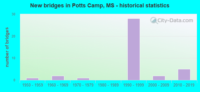
- New bridges - historical statistics
- 11950-1959
- 21960-1969
- 11970-1979
- 281990-1999
- 22000-2009
- 52010-2019


- Bridge Condition - Deck
- 25.0%Very good
- 58.3%Good
- 8.3%Satisfactory
- 8.3%Fair

- Bridge Condition - Superstructure
- 33.3%Very good
- 50.0%Good
- 12.5%Satisfactory
- 4.2%Fair

- Bridge Condition - Substructure
- 29.2%Very good
- 54.2%Good
- 8.3%Satisfactory
- 4.2%Fair
- 4.2%Imminent failure

- Bridge Condition - Channel
- 16.7%Excellent
- 22.2%Very good
- 44.4%Good
- 16.7%Satisfactory
Find on map >> Show street view
Structure Number: 21000780470399A, Location: 7.7 MI E SR 7 (Lat: 34.676036, Lng: -89.330350), Route carried "on" structure: Interstate 22, Year Built: 1993, Status: Open, Structure Length: 19.81m (64.99ft), Average Daily Traffic: 9,500 (year 2020), Truck Traffic: 41%, Average Future Daily Traffic: 13,000 (year 2040), Design Load: HS 20+Mod, Features Intersected: CHEWALLA CREEK & BN RR
Minimum Vertical Clearance: 30+ m (98+ ft), Kilometerpoint: 4.295, Lanes on structure: 2, Base Highway Network: Yes (Inventory Route: 2, Subroute: 1), Owner: State Highway Agency, Approaching Roadway Width: 12.8m (42.0ft), Skew: 1 degrees, Material/Design: Prestressed concrete, Design/Construction: Stringer/Multi-beam, Number Of Spans In Main Unit: 1, Number Of Approach Spans: 13, Length of Maximum Span: 34.4m (112.9ft), Curb-To-Curb Width: 12.8m (42.0ft), Out-to-Out Width: 13.7m (44.9ft)
Condition: Deck: Very good, Superstructure: Very good, Substructure: Satisfactory, Channel: Good, Operating Rating: 55.1 metric tons, Method Used To Determine Operating Rating: Load Factor (LF), Inventory Rating: 28.9 metric tons, Method Used To Determine Inventory Rating: Load Factor (LF), Structural Evaluation: Equal to present minimum criteria, Deck Geometry: Equal to present desirable criteria, Underclear: Superior to present desirable criteria, Waterway Adequacy: Superior to present desirable criteria, Approach Roadway Alignment: Equal to present desirable criteria, Designated Inspection Frequency: Every 24 months, Inspection Date: September 2020, Deck Structure Type: Concrete Cast-file-Place
Find on map >> Show street view
Structure Number: 21000780470399B, Location: 7.7 MI E SR 7 (Lat: 34.676233, Lng: -89.332542), Route carried "on" structure: Interstate 22, Year Built: 1993, Status: Open, Structure Length: 20.27m (66.50ft), Average Daily Traffic: 9,500 (year 2020), Truck Traffic: 41%, Average Future Daily Traffic: 13,000 (year 2040), Design Load: HS 20+Mod, Features Intersected: CHEWALLA CREEK & BN RR
Minimum Vertical Clearance: 30+ m (98+ ft), Kilometerpoint: 44.344, Lanes on structure: 2, Base Highway Network: Yes (Inventory Route: 2, Subroute: 1), Owner: State Highway Agency, Approaching Roadway Width: 12.8m (42.0ft), Skew: 1 degrees, Material/Design: Prestressed concrete, Design/Construction: Stringer/Multi-beam, Number Of Spans In Main Unit: 1, Number Of Approach Spans: 13, Length of Maximum Span: 34.4m (112.9ft), Curb-To-Curb Width: 12.8m (42.0ft), Out-to-Out Width: 13.7m (44.9ft)
Condition: Deck: Good, Superstructure: Very good, Substructure: Good, Channel: Good, Operating Rating: 55.1 metric tons, Method Used To Determine Operating Rating: Load Factor (LF), Inventory Rating: 28.9 metric tons, Method Used To Determine Inventory Rating: Load Factor (LF), Structural Evaluation: Better than present minimum criteria, Deck Geometry: Equal to present desirable criteria, Underclear: Superior to present desirable criteria, Waterway Adequacy: Superior to present desirable criteria, Approach Roadway Alignment: Equal to present desirable criteria, Designated Inspection Frequency: Every 24 months, Inspection Date: August 2020, Deck Structure Type: Concrete Cast-file-Place
Find on map >> Show street view
Structure Number: 21000780470410A, Location: 8.8 MI E SR 7 (Lat: 34.666897, Lng: -89.314908), Route carried "on" structure: Interstate 22, Year Built: 1993, Status: Open, Structure Length: 6.10m (20.01ft), Average Daily Traffic: 9,500 (year 2020), Truck Traffic: 41%, Average Future Daily Traffic: 13,000 (year 2040), Design Load: HS 20+Mod, Features Intersected: TIPPAH RIVER RELIEF
Minimum Vertical Clearance: 30+ m (98+ ft), Kilometerpoint: 2.522, Lanes on structure: 2, Base Highway Network: Yes (Inventory Route: 2, Subroute: 1), Owner: State Highway Agency, Approaching Roadway Width: 12.8m (42.0ft), Material/Design: Prestressed concrete continuous, Design/Construction: Stringer/Multi-beam, Number Of Spans In Main Unit: 5, Length of Maximum Span: 12.2m (40.0ft), Curb-To-Curb Width: 12.8m (42.0ft), Out-to-Out Width: 13.7m (44.9ft)
Condition: Deck: Good, Superstructure: Very good, Substructure: Good, Channel: Very good, Operating Rating: 55.0 metric tons, Method Used To Determine Operating Rating: Load Factor (LF), Inventory Rating: 32.9 metric tons, Method Used To Determine Inventory Rating: Load Factor (LF), Structural Evaluation: Better than present minimum criteria, Deck Geometry: Equal to present desirable criteria, Waterway Adequacy: Equal to present desirable criteria, Approach Roadway Alignment: Equal to present desirable criteria, Designated Inspection Frequency: Every 24 months, Inspection Date: September 2020, Deck Structure Type: Concrete Cast-file-Place
Find on map >> Show street view
Structure Number: 21000780470410B, Location: 8.8 MI E SR 7 (Lat: 34.667200, Lng: -89.315547), Route carried "on" structure: Interstate 22, Year Built: 1993, Status: Open, Structure Length: 6.10m (20.01ft), Average Daily Traffic: 9,500 (year 2020), Truck Traffic: 41%, Average Future Daily Traffic: 13,000 (year 2040), Design Load: HS 20+Mod, Features Intersected: TIPPAH RIVER RELIEF
Minimum Vertical Clearance: 30+ m (98+ ft), Kilometerpoint: 46.240, Lanes on structure: 2, Base Highway Network: Yes (Inventory Route: 2, Subroute: 1), Owner: State Highway Agency, Approaching Roadway Width: 12.8m (42.0ft), Material/Design: Prestressed concrete continuous, Design/Construction: Stringer/Multi-beam, Number Of Spans In Main Unit: 5, Length of Maximum Span: 12.2m (40.0ft), Curb-To-Curb Width: 12.8m (42.0ft), Out-to-Out Width: 13.7m (44.9ft)
Condition: Deck: Good, Superstructure: Good, Substructure: Good, Channel: Very good, Operating Rating: 55.0 metric tons, Method Used To Determine Operating Rating: Load Factor (LF), Inventory Rating: 32.9 metric tons, Method Used To Determine Inventory Rating: Load Factor (LF), Structural Evaluation: Better than present minimum criteria, Deck Geometry: Equal to present desirable criteria, Waterway Adequacy: Equal to present desirable criteria, Approach Roadway Alignment: Equal to present desirable criteria, Designated Inspection Frequency: Every 24 months, Inspection Date: August 2020, Deck Structure Type: Concrete Cast-file-Place
Find on map >> Show street view
Structure Number: 21000780470412A, Location: 9.0 MI E SR 7 (Lat: 34.662175, Lng: -89.310606), Route carried "on" structure: Interstate 22, Year Built: 1993, Status: Open, Structure Length: 34.78m (114.11ft), Average Daily Traffic: 9,500 (year 2020), Truck Traffic: 41%, Average Future Daily Traffic: 13,000 (year 2040), Design Load: HS 20+Mod, Features Intersected: TIPPAH RIVER
Minimum Vertical Clearance: 30+ m (98+ ft), Kilometerpoint: 1.865, Lanes on structure: 2, Base Highway Network: Yes (Inventory Route: 2, Subroute: 1), Owner: State Highway Agency, Approaching Roadway Width: 12.8m (42.0ft), Material/Design: Prestressed concrete continuous, Design/Construction: Stringer/Multi-beam, Number Of Spans In Main Unit: 2, Number Of Approach Spans: 23, Length of Maximum Span: 33.5m (109.9ft), Curb-To-Curb Width: 12.8m (42.0ft), Out-to-Out Width: 13.7m (44.9ft)
Condition: Deck: Good, Superstructure: Good, Substructure: Good, Channel: Good, Operating Rating: 45.0 metric tons, Method Used To Determine Operating Rating: Load Factor (LF), Inventory Rating: 9.6 metric tons, Method Used To Determine Inventory Rating: Load Factor (LF), Structural Evaluation: High priority of corrective action, Deck Geometry: Equal to present desirable criteria, Waterway Adequacy: Equal to present desirable criteria, Approach Roadway Alignment: Equal to present desirable criteria, Designated Inspection Frequency: Every 24 months, Inspection Date: September 2020, Deck Structure Type: Concrete Cast-file-Place
Find on map >> Show street view
Structure Number: 21000780470412B, Location: 9.0 MI E SR 7 (Lat: 34.664544, Lng: -89.313128), Route carried "on" structure: Interstate 22, Year Built: 1993, Status: Open, Structure Length: 34.78m (114.11ft), Average Daily Traffic: 9,500 (year 2020), Truck Traffic: 41%, Average Future Daily Traffic: 13,000 (year 2040), Design Load: HS 20+Mod, Features Intersected: TIPPAH RIVER
Minimum Vertical Clearance: 30+ m (98+ ft), Kilometerpoint: 46.608, Lanes on structure: 2, Base Highway Network: Yes (Inventory Route: 2, Subroute: 1), Owner: State Highway Agency, Approaching Roadway Width: 12.8m (42.0ft), Material/Design: Prestressed concrete continuous, Design/Construction: Stringer/Multi-beam, Number Of Spans In Main Unit: 2, Number Of Approach Spans: 23, Length of Maximum Span: 33.5m (109.9ft), Curb-To-Curb Width: 12.8m (42.0ft), Out-to-Out Width: 13.7m (44.9ft)
Condition: Deck: Good, Superstructure: Good, Substructure: Good, Channel: Good, Operating Rating: 55.0 metric tons, Method Used To Determine Operating Rating: Load Factor (LF), Inventory Rating: 28.2 metric tons, Method Used To Determine Inventory Rating: Load Factor (LF), Structural Evaluation: Better than present minimum criteria, Deck Geometry: Equal to present desirable criteria, Waterway Adequacy: Equal to present desirable criteria, Approach Roadway Alignment: Equal to present desirable criteria, Designated Inspection Frequency: Every 24 months, Inspection Date: August 2020, Deck Structure Type: Concrete Cast-file-Place
Find on map >> Show street view
Structure Number: 31001780470401, Location: SR 178 OVER I 22 (Lat: 34.678003, Lng: -89.339333), Route carried "on" structure: State highway 178, Year Built: 1992, Status: Open, Structure Length: 11.49m (37.70ft), Average Daily Traffic: 1,300 (year 2020), Truck Traffic: 11%, Average Future Daily Traffic: 1,300 (year 2040), Design Load: HS 20, Features Intersected: I 22
Minimum Vertical Clearance: 30+ m (98+ ft), Kilometerpoint: 43.319, Lanes on structure: 2, Lanes under structure: 4, Owner: State Highway Agency, Approaching Roadway Width: 9.1m (29.9ft), Skew: 3 degrees, Material/Design: Prestressed concrete continuous, Design/Construction: Stringer/Multi-beam, Number Of Spans In Main Unit: 4, Length of Maximum Span: 32.0m (105.0ft), Curb-To-Curb Width: 9.1m (29.9ft), Out-to-Out Width: 10.0m (32.8ft)
Condition: Deck: Good, Superstructure: Good, Substructure: Good, Operating Rating: 55.7 metric tons, Method Used To Determine Operating Rating: Load Factor (LF), Inventory Rating: 22.1 metric tons, Method Used To Determine Inventory Rating: Load Factor (LF), Structural Evaluation: Somewhat better than minimum adequacy, Deck Geometry: Somewhat better than minimum adequacy, Underclear: Better than present minimum criteria, Approach Roadway Alignment: Equal to present desirable criteria, Designated Inspection Frequency: Every 24 months, Inspection Date: August 2020, Deck Structure Type: Concrete Cast-file-Place
Find on map >> Show street view
Structure Number: 31001780470403, Location: 9.7 MI E SR 7 (Lat: 34.673267, Lng: -89.333072), Route carried "on" structure: State highway 178, Year Built: 2014, Status: Open, Structure Length: 27.32m (89.63ft), Average Daily Traffic: 1,300 (year 2020), Truck Traffic: 11%, Average Future Daily Traffic: 1,300 (year 2040), Design Load: HL 93, Features Intersected: CHEWALLA CREEK & BN RAIL
Minimum Vertical Clearance: 30+ m (98+ ft), Kilometerpoint: 44.152, Lanes on structure: 2, Owner: State Highway Agency, Approaching Roadway Width: 9.1m (29.9ft), Material/Design: Prestressed concrete, Design/Construction: Stringer/Multi-beam, Number Of Spans In Main Unit: 3, Number Of Approach Spans: 6, Length of Maximum Span: 42.0m (137.8ft), Curb-To-Curb Width: 9.1m (29.9ft), Out-to-Out Width: 10.0m (32.8ft)
Condition: Deck: Good, Superstructure: Good, Substructure: Very good, Channel: Very good, Operating Rating: 47.6 metric tons, Method Used To Determine Operating Rating: Load and Resistance Factor (LRFR), Inventory Rating: 36.0 metric tons, Method Used To Determine Inventory Rating: Load and Resistance Factor (LRFR), Structural Evaluation: Better than present minimum criteria, Deck Geometry: Somewhat better than minimum adequacy, Underclear: Superior to present desirable criteria, Waterway Adequacy: Equal to present desirable criteria, Approach Roadway Alignment: Equal to present desirable criteria, Designated Inspection Frequency: Every 24 months, Inspection Date: July 2021, Deck Structure Type: Concrete Cast-file-Place
Find on map >> Show street view
Structure Number: 31001780470413, Location: 2.2 MI W BENTON CL (Lat: 34.666153, Lng: -89.317667), Route carried "on" structure: State highway 178, Year Built: 2016, Status: Open, Structure Length: 7.39m (24.25ft), Average Daily Traffic: 1,300 (year 2020), Truck Traffic: 11%, Average Future Daily Traffic: 1,300 (year 2040), Design Load: HL 93, Features Intersected: TIPPAH RIVER RELIEF
Minimum Vertical Clearance: 30+ m (98+ ft), Kilometerpoint: 45.810, Lanes on structure: 2, Owner: State Highway Agency, Approaching Roadway Width: 9.1m (29.9ft), Material/Design: Prestressed concrete continuous, Design/Construction: Stringer/Multi-beam, Number Of Spans In Main Unit: 3, Length of Maximum Span: 24.4m (80.1ft), Curb-To-Curb Width: 9.1m (29.9ft), Out-to-Out Width: 10.0m (32.8ft)
Condition: Deck: Very good, Superstructure: Very good, Substructure: Very good, Channel: Excellent, Operating Rating: 47.6 metric tons, Method Used To Determine Operating Rating: Load and Resistance Factor (LRFR), Inventory Rating: 36.0 metric tons, Method Used To Determine Inventory Rating: Load and Resistance Factor (LRFR), Structural Evaluation: Equal to present desirable criteria, Deck Geometry: Somewhat better than minimum adequacy, Waterway Adequacy: Superior to present desirable criteria, Approach Roadway Alignment: Equal to present desirable criteria, Designated Inspection Frequency: Every 24 months, Inspection Date: September 2020, Deck Structure Type: Concrete Cast-file-Place
Find on map >> Show street view
Structure Number: 31001780470415, Location: 2.0 MI W BENTON CL (Lat: 34.663169, Lng: -89.315733), Route carried "on" structure: State highway 178, Year Built: 2016, Status: Open, Structure Length: 41.95m (137.63ft), Average Daily Traffic: 1,300 (year 2020), Truck Traffic: 11%, Average Future Daily Traffic: 1,300 (year 2040), Design Load: HL 93, Features Intersected: TIPPAH RIVER
Minimum Vertical Clearance: 30+ m (98+ ft), Kilometerpoint: 46.185, Lanes on structure: 2, Owner: State Highway Agency, Approaching Roadway Width: 9.1m (29.9ft), Material/Design: Prestressed concrete, Design/Construction: Stringer/Multi-beam, Number Of Spans In Main Unit: 3, Number Of Approach Spans: 12, Length of Maximum Span: 42.1m (138.1ft), Curb-To-Curb Width: 9.1m (29.9ft), Out-to-Out Width: 10.0m (32.8ft)
Condition: Deck: Very good, Superstructure: Good, Substructure: Very good, Channel: Excellent, Operating Rating: 47.6 metric tons, Method Used To Determine Operating Rating: Load and Resistance Factor (LRFR), Inventory Rating: 36.0 metric tons, Method Used To Determine Inventory Rating: Load and Resistance Factor (LRFR), Structural Evaluation: Better than present minimum criteria, Deck Geometry: Somewhat better than minimum adequacy, Waterway Adequacy: Superior to present desirable criteria, Approach Roadway Alignment: Equal to present desirable criteria, Designated Inspection Frequency: Every 24 months, Inspection Date: September 2020, Deck Structure Type: Concrete Cast-file-Place
Find on map >> Show street view
Structure Number: 31003490470141, Location: 6.8 MI N UNION CL (Lat: 34.594983, Lng: -89.333633), Route carried "on" structure: State highway 349, Year Built: 2009, Status: Open, Structure Length: 4.32m (14.17ft), Average Daily Traffic: 1,100 (year 2020), Truck Traffic: 11%, Average Future Daily Traffic: 1,100 (year 2040), Design Load: HS 20, Features Intersected: POTTS CREEK
Minimum Vertical Clearance: 30+ m (98+ ft), Kilometerpoint: 12.677, Lanes on structure: 2, Owner: State Highway Agency, Approaching Roadway Width: 12.2m (40.0ft), Material/Design: Prestressed concrete, Design/Construction: Stringer/Multi-beam, Number Of Spans In Main Unit: 1, Number Of Approach Spans: 2, Length of Maximum Span: 18.3m (60.0ft), Curb-To-Curb Width: 12.2m (40.0ft), Out-to-Out Width: 13.0m (42.7ft)
Condition: Deck: Very good, Superstructure: Very good, Substructure: Very good, Channel: Satisfactory, Operating Rating: 58.1 metric tons, Method Used To Determine Operating Rating: Load Factor (LF), Inventory Rating: 31.6 metric tons, Method Used To Determine Inventory Rating: Load Factor (LF), Structural Evaluation: Better than present minimum criteria, Deck Geometry: Better than present minimum criteria, Waterway Adequacy: Equal to present desirable criteria, Approach Roadway Alignment: Equal to present desirable criteria, Designated Inspection Frequency: Every 48 months, Inspection Date: January 2020, Deck Structure Type: Concrete Cast-file-Place
Find on map >> Show street view
Structure Number: 31003490470184, Location: 10.6 MI N UNION CL (Lat: 34.641631, Lng: -89.310108), Route carried "on" structure: State highway 349, Year Built: 2012, Status: Open, Structure Length: 11.63m (38.16ft), Average Daily Traffic: 2,300 (year 2020), Truck Traffic: 11%, Average Future Daily Traffic: 2,300 (year 2040), Design Load: HL 93, Features Intersected: OAKLIMETER CREEK
Minimum Vertical Clearance: 30+ m (98+ ft), Kilometerpoint: 18.627, Lanes on structure: 2, Owner: State Highway Agency, Approaching Roadway Width: 13.4m (44.0ft), Material/Design: Prestressed concrete, Design/Construction: Stringer/Multi-beam, Number Of Spans In Main Unit: 1, Number Of Approach Spans: 7, Length of Maximum Span: 30.5m (100.1ft), Curb-To-Curb Width: 13.4m (44.0ft), Out-to-Out Width: 14.3m (46.9ft)
Condition: Deck: Very good, Superstructure: Very good, Substructure: Very good, Channel: Excellent, Operating Rating: 51.9 metric tons, Method Used To Determine Operating Rating: Load and Resistance Factor (LRFR), Inventory Rating: 39.4 metric tons, Method Used To Determine Inventory Rating: Load and Resistance Factor (LRFR), Structural Evaluation: Equal to present desirable criteria, Deck Geometry: Better than present minimum criteria, Waterway Adequacy: Equal to present desirable criteria, Approach Roadway Alignment: Equal to present desirable criteria, Designated Inspection Frequency: Every 24 months, Inspection Date: December 2020, Deck Structure Type: Concrete Cast-file-Place
Find on map >> Show street view
Structure Number: 41000780050428, Location: 0.3 MI E MARSHALL CL (Lat: 34.645489, Lng: -89.296183), Route carried "on" structure: County highway , Year Built: 1993, Status: Open, Structure Length: 12.83m (42.09ft), Average Daily Traffic: 270 (year 2020), Truck Traffic: 10%, Average Future Daily Traffic: 270 (year 2040), Design Load: HS 20, Features Intersected: I 22, Facility Carried by Structure: BECK SPRINGS ROAD
Minimum Vertical Clearance: 30+ m (98+ ft), Kilometerpoint: 0.198, Lanes on structure: 2, Lanes under structure: 4, Owner: State Highway Agency, Approaching Roadway Width: 8.5m (27.9ft), Skew: 4 degrees, Material/Design: Concrete continuous, Design/Construction: Box Beam or Girders - Single/Spread, Number Of Spans In Main Unit: 2, Number Of Approach Spans: 2, Length of Maximum Span: 35.4m (116.1ft), Curb-To-Curb Width: 8.5m (27.9ft), Out-to-Out Width: 9.4m (30.8ft)
Condition: Deck: Good, Superstructure: Good, Substructure: Very good, Inventory Rating: 55.7 metric tons, Method Used To Determine Inventory Rating: Load Factor (LF), Structural Evaluation: Better than present minimum criteria, Deck Geometry: Equal to present minimum criteria, Underclear: Superior to present desirable criteria, Approach Roadway Alignment: Equal to present desirable criteria, Designated Inspection Frequency: Every 24 months, Inspection Date: April 2020, Deck Structure Type: Concrete Cast-file-Place
Find on map >> Show street view
Structure Number: 41000780050432, Location: 0.6 MI E MARSHALL CL (Lat: 34.641178, Lng: -89.290317), Route carried "on" structure: County highway , Year Built: 1993, Status: Open, Structure Length: 11.03m (36.19ft), Average Daily Traffic: 180 (year 2020), Truck Traffic: 11%, Average Future Daily Traffic: 180 (year 2040), Design Load: HS 20, Features Intersected: I 22, Facility Carried by Structure: SAW MILL ROAD
Minimum Vertical Clearance: 30+ m (98+ ft), Kilometerpoint: 0.311, Lanes on structure: 2, Lanes under structure: 4, Owner: State Highway Agency, Approaching Roadway Width: 8.5m (27.9ft), Skew: 2 degrees, Material/Design: Prestressed concrete continuous, Design/Construction: Stringer/Multi-beam, Number Of Spans In Main Unit: 2, Number Of Approach Spans: 2, Length of Maximum Span: 32.0m (105.0ft), Curb-To-Curb Width: 8.5m (27.9ft), Out-to-Out Width: 9.4m (30.8ft)
Condition: Deck: Good, Superstructure: Good, Substructure: Good, Operating Rating: 75.6 metric tons, Method Used To Determine Operating Rating: Load Factor (LF), Inventory Rating: 24.3 metric tons, Method Used To Determine Inventory Rating: Load Factor (LF), Structural Evaluation: Equal to present minimum criteria, Deck Geometry: Equal to present minimum criteria, Underclear: Equal to present minimum criteria, Approach Roadway Alignment: Equal to present desirable criteria, Designated Inspection Frequency: Every 24 months, Inspection Date: April 2020, Deck Structure Type: Concrete Cast-file-Place
Find on map >> Show street view
Structure Number: 41000780050448, Location: 2.3 MI E MARSHALL CL (Lat: 34.636908, Lng: -89.263208), Route carried "on" structure: County highway , Year Built: 1993, Status: Open, Structure Length: 12.80m (41.99ft), Average Daily Traffic: 170 (year 2020), Truck Traffic: 8%, Average Future Daily Traffic: 170 (year 2040), Design Load: HS 20, Features Intersected: I 22, Facility Carried by Structure: WATTS ROAD
Minimum Vertical Clearance: 30+ m (98+ ft), Kilometerpoint: 4.337, Lanes on structure: 2, Lanes under structure: 4, Owner: State Highway Agency, Approaching Roadway Width: 8.5m (27.9ft), Material/Design: Prestressed concrete continuous, Design/Construction: Stringer/Multi-beam, Number Of Spans In Main Unit: 2, Number Of Approach Spans: 2, Length of Maximum Span: 32.3m (106.0ft), Curb-To-Curb Width: 8.5m (27.9ft), Out-to-Out Width: 9.4m (30.8ft)
Condition: Deck: Very good, Superstructure: Very good, Substructure: Good, Operating Rating: 81.9 metric tons, Method Used To Determine Operating Rating: Load Factor (LF), Inventory Rating: 36.4 metric tons, Method Used To Determine Inventory Rating: Load Factor (LF), Structural Evaluation: Better than present minimum criteria, Deck Geometry: Equal to present minimum criteria, Underclear: Somewhat better than minimum adequacy, Approach Roadway Alignment: Equal to present desirable criteria, Designated Inspection Frequency: Every 24 months, Inspection Date: April 2020, Deck Structure Type: Concrete Cast-file-Place
Find on map >> Show street view
Structure Number: 41000780470381, Location: 5.9 MI E SR 7 (Lat: 34.682100, Lng: -89.363714), Route carried "on" structure: County highway , Year Built: 1993, Status: Open, Structure Length: 9.81m (32.19ft), Average Daily Traffic: 750 (year 2020), Truck Traffic: 8%, Average Future Daily Traffic: 750 (year 2040), Design Load: HS 20, Features Intersected: I 22, Facility Carried by Structure: CCC ROAD
Minimum Vertical Clearance: 30+ m (98+ ft), Kilometerpoint: 0.393, Lanes on structure: 2, Lanes under structure: 4, Owner: State Highway Agency, Approaching Roadway Width: 17.1m (56.1ft), Material/Design: Prestressed concrete continuous, Design/Construction: Stringer/Multi-beam, Number Of Spans In Main Unit: 2, Number Of Approach Spans: 2, Length of Maximum Span: 27.4m (89.9ft), Curb-To-Curb Width: 17.1m (56.1ft), Out-to-Out Width: 17.9m (58.7ft)
Condition: Deck: Good, Superstructure: Good, Substructure: Good, Operating Rating: 35.8 metric tons, Method Used To Determine Operating Rating: Load Factor (LF), Inventory Rating: 35.7 metric tons, Method Used To Determine Inventory Rating: Load Factor (LF), Structural Evaluation: Better than present minimum criteria, Deck Geometry: Superior to present desirable criteria, Underclear: Equal to present minimum criteria, Approach Roadway Alignment: Equal to present desirable criteria, Designated Inspection Frequency: Every 24 months, Inspection Date: August 2020, Deck Structure Type: Concrete Cast-file-Place
Find on map >> Show street view
Structure Number: 41000780470406, Location: 8.4 MI E SR 7 (Lat: 34.671203, Lng: -89.320614), Route carried "on" structure: County highway , Year Built: 1993, Status: Open, Structure Length: 10.52m (34.51ft), Average Daily Traffic: 270 (year 2020), Truck Traffic: 8%, Average Future Daily Traffic: 270 (year 2040), Design Load: HS 20, Features Intersected: I 22, Facility Carried by Structure: BETHANY ROAD
Minimum Vertical Clearance: 30+ m (98+ ft), Kilometerpoint: 0.208, Lanes on structure: 2, Lanes under structure: 4, Owner: State Highway Agency, Approaching Roadway Width: 8.5m (27.9ft), Skew: 1 degrees, Material/Design: Prestressed concrete continuous, Design/Construction: Stringer/Multi-beam, Number Of Spans In Main Unit: 2, Number Of Approach Spans: 2, Length of Maximum Span: 33.5m (109.9ft), Curb-To-Curb Width: 8.5m (27.9ft), Out-to-Out Width: 9.4m (30.8ft)
Condition: Deck: Good, Superstructure: Good, Substructure: Good, Operating Rating: 59.0 metric tons, Method Used To Determine Operating Rating: Load Factor (LF), Inventory Rating: 30.4 metric tons, Method Used To Determine Inventory Rating: Load Factor (LF), Structural Evaluation: Better than present minimum criteria, Deck Geometry: Equal to present minimum criteria, Underclear: Equal to present desirable criteria, Approach Roadway Alignment: Equal to present desirable criteria, Designated Inspection Frequency: Every 24 months, Inspection Date: August 2020, Deck Structure Type: Concrete Cast-file-Place
Find on map >> Show street view
Structure Number: 4100078047042, Location: 9.8 MI E SR 7 (Lat: 34.654753, Lng: -89.304686), Route carried "on" structure: County highway , Year Built: 1993, Status: Open, Structure Length: 10.52m (34.51ft), Average Daily Traffic: 2,100 (year 2020), Truck Traffic: 10%, Average Future Daily Traffic: 2,100 (year 2040), Design Load: HS 20, Features Intersected: I 22, Facility Carried by Structure: OAK STREET
Minimum Vertical Clearance: 30+ m (98+ ft), Kilometerpoint: 0.565, Lanes on structure: 3, Lanes under structure: 4, Owner: State Highway Agency, Approaching Roadway Width: 17.1m (56.1ft), Skew: 1 degrees, Material/Design: Prestressed concrete continuous, Design/Construction: Stringer/Multi-beam, Number Of Spans In Main Unit: 2, Number Of Approach Spans: 2, Length of Maximum Span: 30.5m (100.1ft), Curb-To-Curb Width: 17.1m (56.1ft), Out-to-Out Width: 17.9m (58.7ft)
Condition: Deck: Good, Superstructure: Good, Substructure: Good, Operating Rating: 56.1 metric tons, Method Used To Determine Operating Rating: Load Factor (LF), Inventory Rating: 24.8 metric tons, Method Used To Determine Inventory Rating: Load Factor (LF), Structural Evaluation: Equal to present minimum criteria, Deck Geometry: Superior to present desirable criteria, Underclear: Equal to present minimum criteria, Approach Roadway Alignment: Equal to present desirable criteria, Designated Inspection Frequency: Every 24 months, Inspection Date: August 2020, Deck Structure Type: Concrete Cast-file-Place
Find on map >> Show street view
Structure Number: SA0500000000039, Location: SEC 1 T 5S R 1W B (Lat: 34.673889, Lng: -89.253611), Route carried "on" structure: County highway 2912, Year Built: 1957, Status: Open, Structure Length: 0.67m (2.20ft), Average Daily Traffic: 260 (year 2015), Truck Traffic: 8%, Average Future Daily Traffic: 390 (year 2035), Design Load: HS 20, Features Intersected: BRADY BRANCH, Facility Carried by Structure: BECK SPRINGS RD
Minimum Vertical Clearance: 30+ m (98+ ft), Kilometerpoint: 6.115, Lanes on structure: 2, Owner: County Highway Agency, Approaching Roadway Width: 6.7m (22.0ft), Material/Design: Concrete, Design/Construction: Culvert, Number Of Spans In Main Unit: 2, Length of Maximum Span: 3.0m (9.8ft)
Condition: Channel: Satisfactory, Culverts: Very good, Operating Rating: 53.6 metric tons, Method Used To Determine Operating Rating: Load Factor (LF), Inventory Rating: 32.0 metric tons, Method Used To Determine Inventory Rating: Load Factor (LF), Structural Evaluation: Better than present minimum criteria, Waterway Adequacy: Equal to present desirable criteria, Approach Roadway Alignment: Equal to present desirable criteria, Designated Inspection Frequency: Every 24 months, Inspection Date: October 2020
Find on map >> Show street view
Structure Number: SA0500000000044, Location: SEC 26 T 5S R 1W B (Lat: 34.624783, Lng: -89.275414), Route carried "on" structure: County highway 115, Year Built: 1960, Status: Temporarily open, Structure Length: 2.32m (7.61ft), Average Daily Traffic: 40 (year 2021), Average Future Daily Traffic: 60 (year 2040), Design Load: HS 20, Features Intersected: UNNAMED CREEK, Facility Carried by Structure: BRENTS ROAD
Minimum Vertical Clearance: 30+ m (98+ ft), Kilometerpoint: 3.218, Lanes on structure: 2, Owner: County Highway Agency, Approaching Roadway Width: 5.5m (18.0ft), Material/Design: Concrete, Design/Construction: Channel Beam, Number Of Spans In Main Unit: 4, Length of Maximum Span: 5.8m (19.0ft), Curb or Sidewalk Widths: Left: 0.2m (0.7ft), Right: 0.2m (0.7ft), Curb-To-Curb Width: 7.1m (23.3ft), Out-to-Out Width: 7.5m (24.6ft)
Condition: Deck: Satisfactory, Superstructure: Satisfactory, Substructure: Imminent failure, Channel: Good, Deck Geometry: Somewhat better than minimum adequacy, Waterway Adequacy: Equal to present desirable criteria, Approach Roadway Alignment: Equal to present desirable criteria, Length Of Structure Improvement: 3.72m (12.20ft), Designated Inspection Frequency: Every 12 months, Inspection Date: September 2021, Bridge Improvement Cost: $222,000, Roadway Improvement Cost: $25,000, Total Project Cost: $276,000 ( Estimate for 2016), Deck Structure Type: Concrete Precast Panels, Wearing Surface/Protective System: Wearing Surface: Monolithic Concrete
Find on map >> Show street view
Structure Number: SA0500000000045, Location: SEC 26 T 5S R 1W B (Lat: 34.628611, Lng: -89.274444), Route carried "on" structure: County highway 115, Year Built: 1960, Status: Posted for load, Structure Length: 5.85m (19.19ft), Average Daily Traffic: 40 (year 2015), Average Future Daily Traffic: 60 (year 2035), Design Load: HS 20, Features Intersected: TIPPAH RIVER, Facility Carried by Structure: BRENT ROAD
Minimum Vertical Clearance: 30+ m (98+ ft), Kilometerpoint: 3.701, Lanes on structure: 2, Owner: County Highway Agency, Approaching Roadway Width: 6.1m (20.0ft), Material/Design: Concrete, Design/Construction: Stringer/Multi-beam, Number Of Spans In Main Unit: 1, Number Of Approach Spans: 8, Length of Maximum Span: 12.2m (40.0ft), Curb or Sidewalk Widths: Left: 0.2m (0.7ft), Right: 0.2m (0.7ft), Curb-To-Curb Width: 6.7m (22.0ft), Out-to-Out Width: 7.1m (23.3ft)
Condition: Deck: Fair, Superstructure: Fair, Substructure: Fair, Channel: Good, Operating Rating: 4.9 metric tons, Method Used To Determine Operating Rating: Load Factor (LF), Inventory Rating: 3.0 metric tons, Method Used To Determine Inventory Rating: Load Factor (LF), Structural Evaluation: High priority of replacement, Deck Geometry: Somewhat better than minimum adequacy, Waterway Adequacy: Better than present minimum criteria, Approach Roadway Alignment: Equal to present minimum criteria, Bridge Posting: Required (Relationship of Operating Rating to Maximum Legal Load: > 39.9% below), Length Of Structure Improvement: 7.32m (24.02ft), Designated Inspection Frequency: Every 12 months, Inspection Date: September 2021, Bridge Improvement Cost: $437,000, Roadway Improvement Cost: $45,000, Total Project Cost: $540,000 ( Estimate for 2016), Deck Structure Type: Concrete Precast Panels, Wearing Surface/Protective System: Wearing Surface: Monolithic Concrete
Find on map >> Show street view
Structure Number: SA4700000000108, Location: SEC 5 T 5S R 1W B (Lat: 34.678153, Lng: -89.332322), Route carried "on" structure: County highway 251, Year Built: 1998, Status: Posted for load, Structure Length: 2.64m (8.66ft), Average Daily Traffic: 60 (year 2013), Average Future Daily Traffic: 75 (year 2038), Features Intersected: CHEWALLA CREEK, Facility Carried by Structure: LACY IVY ROAD
Minimum Vertical Clearance: 30+ m (98+ ft), Kilometerpoint: 0.965, Lanes on structure: 2, Owner: County Highway Agency, Approaching Roadway Width: 6.4m (21.0ft), Material/Design: Steel, Design/Construction: Box Beam or Girders - Multiple, Number Of Spans In Main Unit: 3, Length of Maximum Span: 22.6m (74.1ft), Curb-To-Curb Width: 7.8m (25.6ft), Out-to-Out Width: 8.0m (26.2ft)
Condition: Deck: Satisfactory, Superstructure: Satisfactory, Substructure: Satisfactory, Channel: Very good, Operating Rating: 5.0 metric tons, Method Used To Determine Operating Rating: Load Factor (LF), Inventory Rating: 3.2 metric tons, Method Used To Determine Inventory Rating: Load Factor (LF), Structural Evaluation: High priority of replacement, Deck Geometry: Equal to present minimum criteria, Waterway Adequacy: Better than present minimum criteria, Approach Roadway Alignment: Somewhat better than minimum adequacy, Bridge Posting: Required (Relationship of Operating Rating to Maximum Legal Load: > 39.9% below), Length Of Structure Improvement: 3.58m (11.75ft), Designated Inspection Frequency: Every 24 months, Critical Feature Inspection Frequency: Every 24 months, Inspection Date: November 2020, Critical Feature Inspection Date: November 2020, Bridge Improvement Cost: $193,000, Roadway Improvement Cost: $48,000, Total Project Cost: $290,000 ( Estimate for 2015), Deck Structure Type: Steel plate, Wearing Surface/Protective System: Wearing Surface: Bituminous
Find on map >> Show street view
Structure Number: SA4700000000109, Location: SEC 19 T 5S R 1W B (Lat: 34.626297, Lng: -89.346475), Route carried "on" structure: County highway 25, Year Built: 1970, Status: Open, Structure Length: 20.73m (68.01ft), Average Daily Traffic: 450 (year 2018), Truck Traffic: 8%, Average Future Daily Traffic: 675 (year 2038), Design Load: HS 15, Features Intersected: TIPPAH RIVER, Facility Carried by Structure: POTTS CAMP ROAD
Minimum Vertical Clearance: 30+ m (98+ ft), Kilometerpoint: 14.001, Lanes on structure: 2, Owner: County Highway Agency, Approaching Roadway Width: 8.8m (28.9ft), Material/Design: Prestressed concrete, Design/Construction: Stringer/Multi-beam, Number Of Spans In Main Unit: 13, Length of Maximum Span: 24.4m (80.1ft), Curb or Sidewalk Widths: Left: 0.2m (0.7ft), Right: 0.2m (0.7ft), Curb-To-Curb Width: 7.9m (25.9ft), Out-to-Out Width: 8.8m (28.9ft)
Condition: Deck: Fair, Superstructure: Good, Substructure: Good, Channel: Satisfactory, Operating Rating: 49.6 metric tons, Method Used To Determine Operating Rating: Load Factor (LF) rating reported by rating factor (RF) method using MS18 loading, Inventory Rating: 27.2 metric tons, Method Used To Determine Inventory Rating: Load Factor (LF) rating reported by rating factor (RF) method using MS18 loading, Structural Evaluation: Equal to present minimum criteria, Deck Geometry: Somewhat better than minimum adequacy, Waterway Adequacy: Superior to present desirable criteria, Approach Roadway Alignment: Equal to present desirable criteria, Designated Inspection Frequency: Every 24 months, Inspection Date: March 2020, Deck Structure Type: Concrete Cast-file-Place, Wearing Surface/Protective System: Wearing Surface: Monolithic Concrete
Find on map >> Show street view
Structure Number: SA4700000000128, Location: SEC 4 T 6S R 1W (Lat: 34.594967, Lng: -89.313186), Route carried "on" structure: County highway 32, Year Built: 2001, Status: Open, Structure Length: 3.10m (10.17ft), Average Daily Traffic: 95 (year 2018), Average Future Daily Traffic: 143 (year 2038), Design Load: HS 20, Features Intersected: POTTS CREEK, Facility Carried by Structure: MACEDONIA ROAD
Minimum Vertical Clearance: 30+ m (98+ ft), Kilometerpoint: 2.735, Lanes on structure: 2, Owner: County Highway Agency, Approaching Roadway Width: 7.8m (25.6ft), Material/Design: Prestressed concrete, Design/Construction: Stringer/Multi-beam, Number Of Spans In Main Unit: 3, Length of Maximum Span: 12.2m (40.0ft), Curb or Sidewalk Widths: Left: 0.4m (1.3ft), Right: 0.4m (1.3ft), Curb-To-Curb Width: 8.0m (26.2ft), Out-to-Out Width: 8.8m (28.9ft)
Condition: Deck: Good, Superstructure: Very good, Substructure: Very good, Channel: Good, Operating Rating: 60.9 metric tons, Method Used To Determine Operating Rating: Load Factor (LF) rating reported by rating factor (RF) method using MS18 loading, Inventory Rating: 34.7 metric tons, Method Used To Determine Inventory Rating: Load Factor (LF) rating reported by rating factor (RF) method using MS18 loading, Structural Evaluation: Equal to present desirable criteria, Deck Geometry: Equal to present minimum criteria, Waterway Adequacy: Equal to present desirable criteria, Approach Roadway Alignment: Better than present minimum criteria, Designated Inspection Frequency: Every 24 months, Inspection Date: March 2020, Deck Structure Type: Concrete Cast-file-Place, Wearing Surface/Protective System: Wearing Surface: Monolithic Concrete
Find on map >> Show street view
Structure Number: SA470000000A074, Location: SEC 31 T 4S R 1W B (Lat: 34.689639, Lng: -89.342667), Route carried "on" structure: County highway 252, Year Built: 2015, Status: Open, Structure Length: 1.11m (3.64ft), Average Daily Traffic: 65 (year 2011), Truck Traffic: 8%, Average Future Daily Traffic: 90 (year 2038), Features Intersected: TRIBUTARY CHEWALLA CREEK, Facility Carried by Structure: JOE COX ROAD
Minimum Vertical Clearance: 30+ m (98+ ft), Kilometerpoint: 3.057, Lanes on structure: 2, Owner: County Highway Agency, Approaching Roadway Width: 4.9m (16.1ft), Material/Design: Steel, Design/Construction: Stringer/Multi-beam, Number Of Spans In Main Unit: 1, Length of Maximum Span: 10.8m (35.4ft), Curb or Sidewalk Widths: Left: 0.2m (0.7ft), Right: 0.2m (0.7ft), Curb-To-Curb Width: 7.6m (24.9ft), Out-to-Out Width: 7.6m (24.9ft)
Condition: Deck: Good, Superstructure: Satisfactory, Substructure: Good, Channel: Good, Operating Rating: 56.0 metric tons, Method Used To Determine Operating Rating: Load Factor (LF), Inventory Rating: 33.5 metric tons, Method Used To Determine Inventory Rating: Load Factor (LF), Structural Evaluation: Equal to present minimum criteria, Deck Geometry: Equal to present minimum criteria, Waterway Adequacy: Better than present minimum criteria, Approach Roadway Alignment: Equal to present desirable criteria, Length Of Structure Improvement: 19.30m (63.32ft), Designated Inspection Frequency: Every 24 months, Inspection Date: December 2021, Bridge Improvement Cost: $104,000, Roadway Improvement Cost: $26,000, Total Project Cost: $195,000 ( Estimate for 2016), Deck Structure Type: Steel plate, Wearing Surface/Protective System: Wearing Surface: Bituminous
Find on map >> Show street view
Structure Number: 31001780470401, Location: SR 178 OVER I 22 (Lat: 34.677369, Lng: -89.339081), Route carried "under" structure: Interstate 22, Year Built: 1992, Structure Length: 0. m, Average Daily Traffic: 7,000 (year 2017), Truck Traffic: 17%, Features Intersected: I 22, Facility Carried by Structure: SR 178
Minimum Vertical Clearance: 5.13m (16.83ft), Kilometerpoint: 43.732, Lanes on structure: 2, Lanes under structure: 4, Material/Design: Prestressed concrete continuous, Design/Construction: Stringer/Multi-beam, Length of Maximum Span: 32.0m (105.0ft)
Find on map >> Show street view
Structure Number: 31001780470401, Location: SR 178 OVER I 22 (Lat: 34.677639, Lng: -89.339181), Route carried "under" structure: Interstate 22, Year Built: 1992, Structure Length: 0. m, Average Daily Traffic: 7,000 (year 2017), Truck Traffic: 17%, Features Intersected: I 22, Facility Carried by Structure: SR 178
Minimum Vertical Clearance: 5.49m (18.01ft), Kilometerpoint: 5.124, Lanes on structure: 2, Lanes under structure: 4, Material/Design: Prestressed concrete continuous, Design/Construction: Stringer/Multi-beam, Length of Maximum Span: 32.0m (105.0ft)
Find on map >> Show street view
Structure Number: 41000780050428, Location: 0.3 MI E MARSHALL CL (Lat: 34.645489, Lng: -89.295689), Route carried "under" structure: Interstate 22, Year Built: 1993, Structure Length: 0. m, Average Daily Traffic: 7,500 (year 2017), Truck Traffic: 17%, Features Intersected: I 22, Facility Carried by Structure: BECK SPRINGS ROAD
Minimum Vertical Clearance: 5.38m (17.65ft), Kilometerpoint: 0.401, Lanes on structure: 2, Lanes under structure: 4, Material/Design: Concrete continuous, Design/Construction: Box Beam or Girders - Single/Spread, Length of Maximum Span: 35.4m (116.1ft)
Find on map >> Show street view
Structure Number: 41000780050428, Location: 0.3 MI E MARSHALL CL (Lat: 34.645489, Lng: -89.295311), Route carried "under" structure: Interstate 22, Year Built: 1993, Structure Length: 0. m, Average Daily Traffic: 7,500 (year 2017), Truck Traffic: 17%, Features Intersected: I 22, Facility Carried by Structure: BECK SPRINGS ROAD
Minimum Vertical Clearance: 5.23m (17.16ft), Kilometerpoint: 12.461, Lanes on structure: 2, Lanes under structure: 4, Material/Design: Concrete continuous, Design/Construction: Box Beam or Girders - Single/Spread, Length of Maximum Span: 35.4m (116.1ft)
Find on map >> Show street view
Structure Number: 41000780050432, Location: 0.6 MI E MARSHALL CL (Lat: 34.641731, Lng: -89.290161), Route carried "under" structure: Interstate 22, Year Built: 1993, Structure Length: 0. m, Average Daily Traffic: 7,500 (year 2017), Truck Traffic: 17%, Features Intersected: I 22, Facility Carried by Structure: SAW MILL ROAD
Minimum Vertical Clearance: 6.68m (21.92ft), Kilometerpoint: 11.830, Lanes on structure: 2, Lanes under structure: 4, Material/Design: Prestressed concrete continuous, Design/Construction: Stringer/Multi-beam, Length of Maximum Span: 32.0m (105.0ft)
Find on map >> Show street view
Structure Number: 41000780050432, Location: 0.6 MI E MARSHALL CL (Lat: 34.641481, Lng: -89.290231), Route carried "under" structure: Interstate 22, Year Built: 1993, Structure Length: 0. m, Average Daily Traffic: 7,500 (year 2017), Truck Traffic: 17%, Features Intersected: I 22, Facility Carried by Structure: SAW MILL ROAD
Minimum Vertical Clearance: 5.03m (16.50ft), Kilometerpoint: 1.072, Lanes on structure: 2, Lanes under structure: 4, Material/Design: Prestressed concrete continuous, Design/Construction: Stringer/Multi-beam, Length of Maximum Span: 32.0m (105.0ft)
Find on map >> Show street view
Structure Number: 41000780050448, Location: 2.3 MI E MARSHALL CL (Lat: 34.636461, Lng: -89.263269), Route carried "under" structure: Interstate 22, Year Built: 1993, Structure Length: 0. m, Average Daily Traffic: 7,500 (year 2017), Truck Traffic: 17%, Features Intersected: I 22, Facility Carried by Structure: WATTS ROAD
Minimum Vertical Clearance: 4.98m (16.34ft), Kilometerpoint: 9.263, Lanes on structure: 2, Lanes under structure: 4, Material/Design: Prestressed concrete continuous, Design/Construction: Stringer/Multi-beam, Length of Maximum Span: 32.3m (106.0ft)
Find on map >> Show street view
Structure Number: 41000780050448, Location: 2.3 MI E MARSHALL CL (Lat: 34.636231, Lng: -89.263300), Route carried "under" structure: Interstate 22, Year Built: 1993, Structure Length: 0. m, Average Daily Traffic: 7,500 (year 2017), Truck Traffic: 17%, Features Intersected: I 22, Facility Carried by Structure: WATTS ROAD
Minimum Vertical Clearance: 4.90m (16.08ft), Kilometerpoint: 3.640, Lanes on structure: 2, Lanes under structure: 4, Material/Design: Prestressed concrete continuous, Design/Construction: Stringer/Multi-beam, Length of Maximum Span: 32.3m (106.0ft)
Find on map >> Show street view
Structure Number: 41000780470381, Location: 5.9 MI E SR 7 (Lat: 34.681800, Lng: -89.363781), Route carried "under" structure: Interstate 22, Year Built: 1993, Structure Length: 0. m, Average Daily Traffic: 7,000 (year 2017), Truck Traffic: 17%, Features Intersected: I 22, Facility Carried by Structure: CCC ROAD
Minimum Vertical Clearance: 5.23m (17.16ft), Kilometerpoint: 7.426, Lanes on structure: 2, Lanes under structure: 4, Material/Design: Prestressed concrete continuous, Design/Construction: Stringer/Multi-beam, Length of Maximum Span: 27.4m (89.9ft)
Find on map >> Show street view
Structure Number: 41000780470381, Location: 5.9 MI E SR 7 (Lat: 34.681561, Lng: -89.363831), Route carried "under" structure: Interstate 22, Year Built: 1993, Structure Length: 0. m, Average Daily Traffic: 7,000 (year 2017), Truck Traffic: 17%, Features Intersected: I 22, Facility Carried by Structure: CCC ROAD
Minimum Vertical Clearance: 5.08m (16.67ft), Kilometerpoint: 41.416, Lanes on structure: 2, Lanes under structure: 4, Material/Design: Prestressed concrete continuous, Design/Construction: Stringer/Multi-beam, Length of Maximum Span: 27.4m (89.9ft)
Find on map >> Show street view
Structure Number: 41000780470406, Location: 8.4 MI E SR 7 (Lat: 34.671203, Lng: -89.320614), Route carried "under" structure: Interstate 22, Year Built: 1993, Structure Length: 0. m, Average Daily Traffic: 7,000 (year 2017), Truck Traffic: 17%, Features Intersected: I 22, Facility Carried by Structure: BETHANY ROAD
Minimum Vertical Clearance: 6.25m (20.51ft), Kilometerpoint: 0.209, Lanes on structure: 2, Lanes under structure: 4, Material/Design: Prestressed concrete continuous, Design/Construction: Stringer/Multi-beam, Length of Maximum Span: 33.5m (109.9ft)
Find on map >> Show street view
Structure Number: 41000780470406, Location: 8.4 MI E SR 7 (Lat: 34.671203, Lng: -89.320614), Route carried "under" structure: Interstate 22, Year Built: 1993, Structure Length: 0. m, Average Daily Traffic: 7,000 (year 2017), Truck Traffic: 17%, Features Intersected: I 22, Facility Carried by Structure: BETHANY ROAD
Minimum Vertical Clearance: 5.18m (16.99ft), Kilometerpoint: 0.209, Lanes on structure: 2, Lanes under structure: 4, Material/Design: Prestressed concrete continuous, Design/Construction: Stringer/Multi-beam, Length of Maximum Span: 33.5m (109.9ft)
Find on map >> Show street view
Structure Number: 4100078047042, Location: 9.8 MI E SR 7 (Lat: 34.654753, Lng: -89.304686), Route carried "under" structure: Interstate 22, Year Built: 1993, Structure Length: 0. m, Average Daily Traffic: 7,500 (year 2017), Truck Traffic: 17%, Features Intersected: I 22, Facility Carried by Structure: OAK STREET
Minimum Vertical Clearance: 6.14m (20.14ft), Kilometerpoint: 0.565, Lanes on structure: 3, Lanes under structure: 4, Material/Design: Prestressed concrete continuous, Design/Construction: Stringer/Multi-beam, Length of Maximum Span: 30.5m (100.1ft)
Find on map >> Show street view
Structure Number: 4100078047042, Location: 9.8 MI E SR 7 (Lat: 34.654753, Lng: -89.304686), Route carried "under" structure: Interstate 22, Year Built: 1993, Structure Length: 0. m, Average Daily Traffic: 7,500 (year 2017), Truck Traffic: 17%, Features Intersected: I 22, Facility Carried by Structure: OAK STREET
Minimum Vertical Clearance: 5.05m (16.57ft), Kilometerpoint: 0.565, Lanes on structure: 3, Lanes under structure: 4, Material/Design: Prestressed concrete continuous, Design/Construction: Stringer/Multi-beam, Length of Maximum Span: 30.5m (100.1ft)