Bridge Statistics for Princeville, Illinois (IL)
Condition, Traffic, Stress, Structural Evaluation, Project Costs
- National Bridge Inventory (NBI) Statistics
- 26Number of bridges
- 131ft / 40.5mTotal length
- $329,000Total costs
- 16,635Total average daily traffic
- 1,401Total average daily truck traffic
- National Bridge Inventory (NBI) Registered Bridges for Princeville
- No street view available for this location
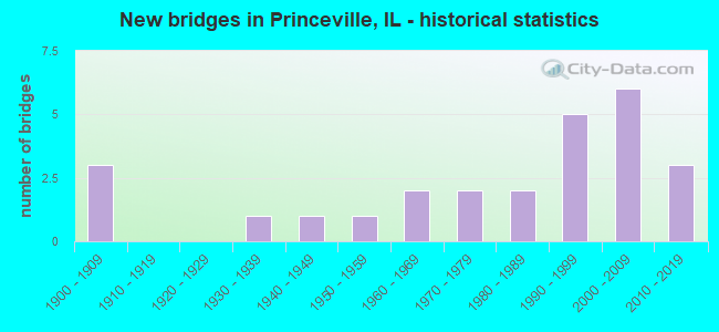
- New bridges - historical statistics
- 31900-1909
- 11930-1939
- 11940-1949
- 11950-1959
- 21960-1969
- 21970-1979
- 21980-1989
- 51990-1999
- 62000-2009
- 32010-2019


- Bridge Condition - Deck
- 6.3%Excellent
- 12.5%Very good
- 25.0%Good
- 50.0%Satisfactory
- 6.3%Serious

- Bridge Condition - Superstructure
- 5.9%Excellent
- 23.5%Very good
- 35.3%Good
- 29.4%Satisfactory
- 5.9%Serious

- Bridge Condition - Substructure
- 5.9%Excellent
- 35.3%Very good
- 29.4%Good
- 11.8%Satisfactory
- 11.8%Fair
- 5.9%Poor

- Bridge Condition - Channel
- 4.3%Excellent
- 4.3%Very good
- 17.4%Good
- 47.8%Satisfactory
- 13.0%Fair
- 8.7%Poor
- 4.3%Serious

- Bridge Condition - Culverts
- 50.0%Good
- 33.3%Fair
- 16.7%Poor
Find on map >> Show street view
Structure Number: 720034, Location: W EDGE OF PRINCEVILE (Lat: 40.930331, Lng: -89.769322), Route carried "on" structure: State highway 90, Year Built: 1933, Year Reconstructed: 1993, Status: Open, Structure Length: 0.79m (2.59ft), Average Daily Traffic: 1,550 (year 2021), Truck Traffic: 16%, Average Future Daily Traffic: 1,487 (year 2032), Design Load: HS 20, Features Intersected: PRINCE RUN
Minimum Vertical Clearance: 30+ m (98+ ft), Kilometerpoint: 13.293, Lanes on structure: 2, Base Highway Network: Yes, Owner: State Highway Agency, Approaching Roadway Width: 10.4m (34.1ft), Material/Design: Concrete, Design/Construction: Slab, Number Of Spans In Main Unit: 1, Length of Maximum Span: 7.6m (24.9ft), Curb-To-Curb Width: 10.1m (33.1ft), Out-to-Out Width: 11.0m (36.1ft)
Condition: Deck: Good, Superstructure: Good, Substructure: Fair, Channel: Satisfactory, Operating Rating: 87.5 metric tons, Method Used To Determine Operating Rating: Load Factor (LF) rating reported by rating factor (RF) method using MS18 loading, Inventory Rating: 52.2 metric tons, Method Used To Determine Inventory Rating: Load Factor (LF) rating reported by rating factor (RF) method using MS18 loading, Structural Evaluation: Somewhat better than minimum adequacy, Deck Geometry: Somewhat better than minimum adequacy, Waterway Adequacy: Equal to present desirable criteria, Approach Roadway Alignment: Equal to present minimum criteria, Designated Inspection Frequency: Every 24 months, Inspection Date: July 2020, Deck Structure Type: Concrete Cast-file-Place, Wearing Surface/Protective System: Deck Protection: Epoxy Coated Reinforcing
Find on map >> Show street view
Structure Number: 720188, Location: 1 MI N PRINCEVILLE (Lat: 40.950989, Lng: -89.755408), Route carried "on" structure: State highway 91, Year Built: 2000, Status: Open, Structure Length: 2.78m (9.12ft), Average Daily Traffic: 1,350 (year 2021), Truck Traffic: 12%, Average Future Daily Traffic: 1,912 (year 2032), Design Load: HS 20, Features Intersected: NORTH CREEK
Minimum Vertical Clearance: 30+ m (98+ ft), Kilometerpoint: 27.278, Lanes on structure: 2, Owner: State Highway Agency, Approaching Roadway Width: 9.6m (31.5ft), Material/Design: Prestressed concrete, Design/Construction: Stringer/Multi-beam, Number Of Spans In Main Unit: 1, Length of Maximum Span: 27.0m (88.6ft), Curb-To-Curb Width: 9.6m (31.5ft), Out-to-Out Width: 10.6m (34.8ft)
Condition: Deck: Satisfactory, Superstructure: Very good, Substructure: Good, Channel: Satisfactory, Operating Rating: 83.3 metric tons, Method Used To Determine Operating Rating: Load Factor (LF) rating reported by rating factor (RF) method using MS18 loading, Inventory Rating: 48.0 metric tons, Method Used To Determine Inventory Rating: Load Factor (LF) rating reported by rating factor (RF) method using MS18 loading, Structural Evaluation: Better than present minimum criteria, Deck Geometry: Somewhat better than minimum adequacy, Waterway Adequacy: Superior to present desirable criteria, Approach Roadway Alignment: Equal to present minimum criteria, Designated Inspection Frequency: Every 48 months, Inspection Date: January 2019, Deck Structure Type: Concrete Cast-file-Place, Wearing Surface/Protective System: Deck Protection: Epoxy Coated Reinforcing
Find on map >> Show street view
Structure Number: 720247, Location: .25 MI E PRINCEVILLE (Lat: 40.930061, Lng: -89.736969), Route carried "on" structure: State highway 90, Year Built: 2017, Status: Open, Structure Length: 1.94m (6.36ft), Average Daily Traffic: 3,100 (year 2021), Truck Traffic: 8%, Average Future Daily Traffic: 4,210 (year 2033), Design Load: HS 25 or greater, Features Intersected: PRINCE CREEK
Minimum Vertical Clearance: 30+ m (98+ ft), Kilometerpoint: 16.077, Lanes on structure: 2, Base Highway Network: Yes, Owner: State Highway Agency, Approaching Roadway Width: 10.4m (34.1ft), Material/Design: Prestressed concrete, Design/Construction: Stringer/Multi-beam, Number Of Spans In Main Unit: 1, Length of Maximum Span: 18.3m (60.0ft), Curb-To-Curb Width: 11.0m (36.1ft), Out-to-Out Width: 11.9m (39.0ft)
Condition: Deck: Very good, Superstructure: Very good, Substructure: Very good, Channel: Excellent, Operating Rating: 47.6 metric tons, Method Used To Determine Operating Rating: Load and Resistance Factor Rating (LRFR) rating reported by rating factor(RF) method using HL-93 loadings, Inventory Rating: 37.9 metric tons, Method Used To Determine Inventory Rating: Load and Resistance Factor Rating (LRFR) rating reported by rating factor(RF) method using HL-93 loadings, Structural Evaluation: Equal to present desirable criteria, Deck Geometry: Somewhat better than minimum adequacy, Waterway Adequacy: Superior to present desirable criteria, Approach Roadway Alignment: Equal to present minimum criteria, Designated Inspection Frequency: Every 48 months, Inspection Date: January 2020, Deck Structure Type: Concrete Cast-file-Place, Wearing Surface/Protective System: Deck Protection: Epoxy Coated Reinforcing
Find on map >> Show street view
Structure Number: 723073, Location: NE1/4 7 RADNOR ROAD (Lat: 40.871694, Lng: -89.740908), Route carried "on" structure: County highway , Year Built: 1959, Status: Open, Structure Length: 0.87m (2.85ft), Average Daily Traffic: 450 (year 2017), Truck Traffic: 7%, Average Future Daily Traffic: 425 (year 2032), Design Load: H 20, Features Intersected: HICKORY CREEK, Facility Carried by Structure: PARKS SCHOOL ROAD
Minimum Vertical Clearance: 30+ m (98+ ft), Kilometerpoint: 13.840, Lanes on structure: 2, Owner: County Highway Agency, Approaching Roadway Width: 8.1m (26.6ft), Skew: 3 degrees, Material/Design: Concrete continuous, Design/Construction: Culvert, Number Of Spans In Main Unit: 2, Length of Maximum Span: 4.2m (13.8ft)
Condition: Channel: Poor, Culverts: Fair, Operating Rating: 35.3 metric tons, Method Used To Determine Operating Rating: Load Factor (LF) rating reported by rating factor (RF) method using MS18 loading, Inventory Rating: 21.1 metric tons, Method Used To Determine Inventory Rating: Load Factor (LF) rating reported by rating factor (RF) method using MS18 loading, Structural Evaluation: Somewhat better than minimum adequacy, Waterway Adequacy: Better than present minimum criteria, Approach Roadway Alignment: Equal to present minimum criteria, Designated Inspection Frequency: Every 24 months, Inspection Date: September 2020
Find on map >> Show street view
Structure Number: 723122, Location: SW-1-T11NR6E (Lat: 40.959678, Lng: -89.772200), Route carried "on" structure: County highway , Year Built: 1988, Status: Open, Structure Length: 3.29m (10.79ft), Average Daily Traffic: 50 (year 2017), Average Future Daily Traffic: 80 (year 2032), Design Load: HS 20, Features Intersected: PRINCE RUN, Facility Carried by Structure: STREITMATTER RD
Minimum Vertical Clearance: 30+ m (98+ ft), Kilometerpoint: 6.260, Lanes on structure: 2, Owner: County Highway Agency, Approaching Roadway Width: 11.0m (36.1ft), Material/Design: Prestressed concrete, Design/Construction: Box Beam or Girders - Multiple, Number Of Spans In Main Unit: 3, Length of Maximum Span: 10.8m (35.4ft), Curb-To-Curb Width: 11.0m (36.1ft), Out-to-Out Width: 11.0m (36.1ft)
Condition: Deck: Satisfactory, Superstructure: Satisfactory, Substructure: Good, Channel: Poor, Operating Rating: 44.4 metric tons, Method Used To Determine Operating Rating: Assigned rating based on Load Factor Design (LFD) reported by rating factor (RF) using MS18 loading, Inventory Rating: 32.4 metric tons, Method Used To Determine Inventory Rating: Assigned rating based on Load Factor Design (LFD) reported by rating factor (RF) using MS18 loading, Structural Evaluation: Equal to present minimum criteria, Deck Geometry: Superior to present desirable criteria, Waterway Adequacy: Equal to present desirable criteria, Approach Roadway Alignment: Better than present minimum criteria, Designated Inspection Frequency: Every 24 months, Inspection Date: September 2020, Deck Structure Type: Concrete Precast Panels, Wearing Surface/Protective System: Wearing Surface: Bituminous, Membrane: Built-up
Find on map >> Show street view
Structure Number: 723123, Location: CTR-3-JUBILEE TWP (Lat: 40.879222, Lng: -89.799917), Route carried "on" structure: County highway , Year Built: 1990, Status: Open, Structure Length: 0.62m (2.03ft), Average Daily Traffic: 300 (year 2017), Truck Traffic: 7%, Average Future Daily Traffic: 372 (year 2032), Design Load: HS 20, Features Intersected: BRANCH KICKAPOO CR, Facility Carried by Structure: PARKS SCH RD
Minimum Vertical Clearance: 30+ m (98+ ft), Kilometerpoint: 8.191, Lanes on structure: 2, Owner: County Highway Agency, Approaching Roadway Width: 7.3m (24.0ft), Skew: 2 degrees, Material/Design: Steel, Design/Construction: Culvert, Number Of Spans In Main Unit: 1, Length of Maximum Span: 6.1m (20.0ft)
Condition: Channel: Serious, Culverts: Good, Operating Rating: 44.4 metric tons, Method Used To Determine Operating Rating: Assigned rating based on Load Factor Design (LFD) reported by rating factor (RF) using MS18 loading, Inventory Rating: 32.4 metric tons, Method Used To Determine Inventory Rating: Assigned rating based on Load Factor Design (LFD) reported by rating factor (RF) using MS18 loading, Structural Evaluation: Better than present minimum criteria, Waterway Adequacy: Better than present minimum criteria, Approach Roadway Alignment: Better than present minimum criteria, Designated Inspection Frequency: Every 24 months, Inspection Date: September 2020
Find on map >> Show street view
Structure Number: 723127, Location: E.CTR-3-T11NR6E (Lat: 40.966231, Lng: -89.793531), Route carried "on" structure: County highway , Year Built: 1991, Status: Open, Structure Length: 2.93m (9.61ft), Average Daily Traffic: 275 (year 2017), Truck Traffic: 10%, Average Future Daily Traffic: 292 (year 2032), Design Load: HS 20, Features Intersected: BR. SPOON RIVER, Facility Carried by Structure: DUNCAN RD.
Minimum Vertical Clearance: 30+ m (98+ ft), Kilometerpoint: 0.837, Lanes on structure: 2, Owner: County Highway Agency, Approaching Roadway Width: 12.2m (40.0ft), Skew: 3 degrees, Material/Design: Prestressed concrete, Design/Construction: Box Beam or Girders - Multiple, Number Of Spans In Main Unit: 3, Length of Maximum Span: 10.2m (33.5ft), Curb-To-Curb Width: 11.0m (36.1ft), Out-to-Out Width: 11.0m (36.1ft)
Condition: Deck: Serious, Superstructure: Serious, Substructure: Poor, Channel: Good, Operating Rating: 34.0 metric tons, Method Used To Determine Operating Rating: Load Factor (LF) rating reported by rating factor (RF) method using MS18 loading, Inventory Rating: 9.4 metric tons, Method Used To Determine Inventory Rating: Load Factor (LF) rating reported by rating factor (RF) method using MS18 loading, Structural Evaluation: High priority of corrective action, Deck Geometry: Equal to present desirable criteria, Waterway Adequacy: Equal to present desirable criteria, Approach Roadway Alignment: Equal to present desirable criteria, Bridge Posting: Required (Relationship of Operating Rating to Maximum Legal Load: > 39.9% below), Designated Inspection Frequency: Every 24 months, Inspection Date: September 2021, Deck Structure Type: Concrete Precast Panels, Wearing Surface/Protective System: Wearing Surface: Bituminous, Membrane: Built-up
Find on map >> Show street view
Structure Number: 723138, Location: SE-2-T10NR6E (Lat: 40.872417, Lng: -89.775031), Route carried "on" structure: County highway , Year Built: 1996, Status: Open, Structure Length: 0.70m (2.30ft), Average Daily Traffic: 2,000 (year 2017), Truck Traffic: 8%, Average Future Daily Traffic: 1,752 (year 2032), Design Load: HS 20, Features Intersected: BR KICKAPOO CREEK, Facility Carried by Structure: PRINCEVILLE JUBILE
Minimum Vertical Clearance: 30+ m (98+ ft), Kilometerpoint: 6.888, Lanes on structure: 2, Owner: County Highway Agency, Approaching Roadway Width: 12.2m (40.0ft), Material/Design: Concrete, Design/Construction: Culvert, Number Of Spans In Main Unit: 2, Length of Maximum Span: 3.4m (11.2ft)
Condition: Channel: Fair, Culverts: Good, Operating Rating: 44.1 metric tons, Method Used To Determine Operating Rating: Assigned rating based on Load Factor Design (LFD) reported by rating factor (RF) using MS18 loading, Inventory Rating: 32.4 metric tons, Method Used To Determine Inventory Rating: Assigned rating based on Load Factor Design (LFD) reported by rating factor (RF) using MS18 loading, Structural Evaluation: Better than present minimum criteria, Waterway Adequacy: Better than present minimum criteria, Approach Roadway Alignment: Better than present minimum criteria, Designated Inspection Frequency: Every 48 months, Inspection Date: September 2019
Find on map >> Show street view
Structure Number: 723141, Location: CTR-24-PRINCEVILLE (Lat: 40.922169, Lng: -89.763089), Route carried "on" structure: County highway , Year Built: 2003, Status: Open, Structure Length: 0.69m (2.26ft), Average Daily Traffic: 1,800 (year 2017), Truck Traffic: 7%, Average Future Daily Traffic: 1,752 (year 2032), Design Load: HS 20, Features Intersected: PRINCE RUN, Facility Carried by Structure: PRINCEVILLE-JUBILE
Minimum Vertical Clearance: 30+ m (98+ ft), Kilometerpoint: 0.885, Lanes on structure: 2, Owner: County Highway Agency, Approaching Roadway Width: 6.7m (22.0ft), Skew: 1 degrees, Material/Design: Concrete, Design/Construction: Culvert, Number Of Spans In Main Unit: 2, Length of Maximum Span: 3.3m (10.8ft)
Condition: Channel: Satisfactory, Culverts: Good, Operating Rating: 44.1 metric tons, Method Used To Determine Operating Rating: Assigned rating based on Load Factor Design (LFD) reported by rating factor (RF) using MS18 loading, Inventory Rating: 32.4 metric tons, Method Used To Determine Inventory Rating: Assigned rating based on Load Factor Design (LFD) reported by rating factor (RF) using MS18 loading, Structural Evaluation: Better than present minimum criteria, Waterway Adequacy: Equal to present desirable criteria, Approach Roadway Alignment: Better than present minimum criteria, Designated Inspection Frequency: Every 48 months, Inspection Date: September 2019, Wearing Surface/Protective System: Wearing Surface: Bituminous, Membrane: Built-up
Find on map >> Show street view
Structure Number: 724201, Location: N.CTR-4-AKRON (Lat: 40.973817, Lng: -89.706611), Route carried "on" structure: County highway , Year Built: 1900, Status: Open, Structure Length: 0.79m (2.59ft), Average Daily Traffic: 10 (year 2017), Average Future Daily Traffic: 11 (year 2032), Features Intersected: BR OF MUD RUN, Facility Carried by Structure: COUNTY LINE ROAD
Minimum Vertical Clearance: 30+ m (98+ ft), Kilometerpoint: 10.477, Lanes on structure: 2, Owner: Town or Township Highway Agency, Approaching Roadway Width: 8.8m (28.9ft), Material/Design: Concrete, Number Of Spans In Main Unit: 1, Length of Maximum Span: 7.6m (24.9ft), Curb-To-Curb Width: 5.5m (18.0ft), Out-to-Out Width: 6.2m (20.3ft)
Condition: Deck: Good, Superstructure: Good, Substructure: Good, Channel: Satisfactory, Operating Rating: 32.4 metric tons, Method Used To Determine Operating Rating: Field evaluation and documented engineering judgment, Inventory Rating: 17.5 metric tons, Method Used To Determine Inventory Rating: Field evaluation and documented engineering judgment, Structural Evaluation: Somewhat better than minimum adequacy, Deck Geometry: Meets minimum limits, Waterway Adequacy: Equal to present minimum criteria, Approach Roadway Alignment: Equal to present minimum criteria, Designated Inspection Frequency: Every 24 months, Inspection Date: September 2020, Deck Structure Type: Concrete Cast-file-Place, Wearing Surface/Protective System: Wearing Surface: Gravel
Find on map >> Show street view
Structure Number: 724205, Location: NW-20-AKRON (Lat: 40.926022, Lng: -89.735783), Route carried "on" structure: County highway , Year Built: 1962, Status: Open, Structure Length: 1.05m (3.44ft), Average Daily Traffic: 50 (year 2017), Average Future Daily Traffic: 53 (year 2032), Design Load: H 20, Features Intersected: BR PRINCE RUN, Facility Carried by Structure: SLANE RD - TR 186
Minimum Vertical Clearance: 30+ m (98+ ft), Kilometerpoint: 5.295, Lanes on structure: 2, Owner: Town or Township Highway Agency, Approaching Roadway Width: 9.1m (29.9ft), Skew: 4 degrees, Material/Design: Concrete continuous, Design/Construction: Culvert, Number Of Spans In Main Unit: 2, Length of Maximum Span: 5.1m (16.7ft)
Condition: Channel: Satisfactory, Culverts: Poor, Operating Rating: 24.9 metric tons, Method Used To Determine Operating Rating: Load Factor (LF) rating reported by rating factor (RF) method using MS18 loading, Inventory Rating: 14.9 metric tons, Method Used To Determine Inventory Rating: Load Factor (LF) rating reported by rating factor (RF) method using MS18 loading, Structural Evaluation: Meets minimum limits, Waterway Adequacy: Better than present minimum criteria, Approach Roadway Alignment: Better than present minimum criteria, Bridge Posting: Required (Relationship of Operating Rating to Maximum Legal Load: > 39.9% below), Designated Inspection Frequency: Every 24 months, Inspection Date: September 2020
Find on map >> Show street view
Structure Number: 724212, Location: CENT 18 AKRON TWP (Lat: 40.939792, Lng: -89.744747), Route carried "on" structure: City street , Year Built: 1973, Status: Open, Structure Length: 1.24m (4.07ft), Average Daily Traffic: 150 (year 2017), Average Future Daily Traffic: 80 (year 2032), Features Intersected: BR PRINCE RUN, Facility Carried by Structure: WOERTZ STREET
Minimum Vertical Clearance: 30+ m (98+ ft), Kilometerpoint: 1.046, Lanes on structure: 2, Owner: City or Municipal Highway Agency, Approaching Roadway Width: 6.1m (20.0ft), Material/Design: Prestressed concrete, Design/Construction: Box Beam or Girders - Multiple, Number Of Spans In Main Unit: 1, Length of Maximum Span: 12.4m (40.7ft), Curb-To-Curb Width: 7.9m (25.9ft), Out-to-Out Width: 8.0m (26.2ft)
Condition: Deck: Good, Superstructure: Good, Substructure: Good, Channel: Satisfactory, Operating Rating: 53.8 metric tons, Method Used To Determine Operating Rating: Field evaluation and documented engineering judgment, Inventory Rating: 32.4 metric tons, Method Used To Determine Inventory Rating: Field evaluation and documented engineering judgment, Structural Evaluation: Better than present minimum criteria, Deck Geometry: Somewhat better than minimum adequacy, Waterway Adequacy: Better than present minimum criteria, Approach Roadway Alignment: Equal to present minimum criteria, Designated Inspection Frequency: Every 24 months, Inspection Date: April 2021, Deck Structure Type: Concrete Precast Panels, Wearing Surface/Protective System: Wearing Surface: Gravel
Find on map >> Show street view
Structure Number: 724213, Location: NW QTR 29 AKRON TWP (Lat: 40.915614, Lng: -89.731967), Route carried "on" structure: County highway , Year Built: 1961, Status: Open, Structure Length: 0.68m (2.23ft), Average Daily Traffic: 75 (year 2017), Average Future Daily Traffic: 80 (year 2032), Design Load: H 20, Features Intersected: Br. of Prince Run, Facility Carried by Structure: Lake Shore Drive
Minimum Vertical Clearance: 30+ m (98+ ft), Kilometerpoint: 1.947, Lanes on structure: 2, Owner: Town or Township Highway Agency, Approaching Roadway Width: 7.3m (24.0ft), Material/Design: Concrete continuous, Design/Construction: Culvert, Number Of Spans In Main Unit: 2, Length of Maximum Span: 3.3m (10.8ft)
Condition: Channel: Satisfactory, Culverts: Fair, Operating Rating: 68.7 metric tons, Method Used To Determine Operating Rating: Load Factor (LF) rating reported by rating factor (RF) method using MS18 loading, Inventory Rating: 41.1 metric tons, Method Used To Determine Inventory Rating: Load Factor (LF) rating reported by rating factor (RF) method using MS18 loading, Structural Evaluation: Somewhat better than minimum adequacy, Waterway Adequacy: Equal to present minimum criteria, Approach Roadway Alignment: Equal to present minimum criteria, Designated Inspection Frequency: Every 24 months, Inspection Date: September 2020
Find on map >> Show street view
Structure Number: 724314, Location: N.CTR-1-T11NR6E (Lat: 40.974111, Lng: -89.765647), Route carried "on" structure: County highway , Year Built: 1975, Status: Open, Structure Length: 1.92m (6.30ft), Average Daily Traffic: 50 (year 2017), Average Future Daily Traffic: 53 (year 2032), Design Load: HS 20, Features Intersected: PRINCE RUN CREEK, Facility Carried by Structure: COUNTY LINE RD-TR
Minimum Vertical Clearance: 30+ m (98+ ft), Kilometerpoint: 5.536, Lanes on structure: 2, Owner: Town or Township Highway Agency, Approaching Roadway Width: 9.1m (29.9ft), Skew: 1 degrees, Material/Design: Prestressed concrete, Design/Construction: Box Beam or Girders - Multiple, Number Of Spans In Main Unit: 1, Length of Maximum Span: 18.3m (60.0ft), Curb-To-Curb Width: 7.6m (24.9ft), Out-to-Out Width: 8.2m (26.9ft)
Condition: Deck: Satisfactory, Superstructure: Satisfactory, Substructure: Satisfactory, Channel: Fair, Operating Rating: 64.8 metric tons, Method Used To Determine Operating Rating: Load Factor (LF) rating reported by rating factor (RF) method using MS18 loading, Inventory Rating: 38.9 metric tons, Method Used To Determine Inventory Rating: Load Factor (LF) rating reported by rating factor (RF) method using MS18 loading, Structural Evaluation: Equal to present minimum criteria, Deck Geometry: Equal to present minimum criteria, Waterway Adequacy: Equal to present desirable criteria, Approach Roadway Alignment: Equal to present desirable criteria, Designated Inspection Frequency: Every 24 months, Inspection Date: September 2020, Deck Structure Type: Concrete Precast Panels, Wearing Surface/Protective System: Wearing Surface: Bituminous
Find on map >> Show street view
Structure Number: 724316, Location: SW-34-T11NR6E (Lat: 40.893147, Lng: -89.813589), Route carried "on" structure: County highway , Year Built: 1996, Status: Open, Structure Length: 2.16m (7.09ft), Average Daily Traffic: 75 (year 2017), Average Future Daily Traffic: 80 (year 2032), Design Load: HS 20, Features Intersected: BR JUBILEE CREEK, Facility Carried by Structure: ELLIOT ROAD
Minimum Vertical Clearance: 30+ m (98+ ft), Kilometerpoint: 9.044, Lanes on structure: 2, Owner: Town or Township Highway Agency, Approaching Roadway Width: 6.7m (22.0ft), Skew: 2 degrees, Material/Design: Prestressed concrete, Design/Construction: Box Beam or Girders - Multiple, Number Of Spans In Main Unit: 1, Length of Maximum Span: 20.7m (67.9ft), Curb-To-Curb Width: 10.1m (33.1ft), Out-to-Out Width: 10.1m (33.1ft)
Condition: Deck: Good, Superstructure: Good, Substructure: Very good, Channel: Fair, Operating Rating: 44.1 metric tons, Method Used To Determine Operating Rating: Assigned rating based on Load Factor Design (LFD) reported by rating factor (RF) using MS18 loading, Inventory Rating: 32.4 metric tons, Method Used To Determine Inventory Rating: Assigned rating based on Load Factor Design (LFD) reported by rating factor (RF) using MS18 loading, Structural Evaluation: Better than present minimum criteria, Deck Geometry: Superior to present desirable criteria, Waterway Adequacy: Equal to present desirable criteria, Approach Roadway Alignment: Somewhat better than minimum adequacy, Designated Inspection Frequency: Every 48 months, Inspection Date: September 2021, Deck Structure Type: Concrete Precast Panels, Wearing Surface/Protective System: Wearing Surface: Bituminous, Membrane: Built-up
Find on map >> Show street view
Structure Number: 724317, Location: NE 1/4 13 T11NR6E (Lat: 40.944814, Lng: -89.764369), Route carried "on" structure: County highway , Year Built: 2013, Status: Open, Structure Length: 1.00m (3.28ft), Average Daily Traffic: 150 (year 2017), Truck Traffic: 13%, Average Future Daily Traffic: 159 (year 2032), Design Load: HS 25 or greater, Features Intersected: PRINCE RUN, Facility Carried by Structure: MENDELL RD - TR 13
Minimum Vertical Clearance: 30+ m (98+ ft), Kilometerpoint: 8.835, Lanes on structure: 2, Owner: Town or Township Highway Agency, Approaching Roadway Width: 9.1m (29.9ft), Skew: 1 degrees, Material/Design: Concrete, Design/Construction: Frame, Number Of Spans In Main Unit: 1, Length of Maximum Span: 9.6m (31.5ft), Curb-To-Curb Width: 9.1m (29.9ft), Out-to-Out Width: 9.1m (29.9ft)
Condition: Superstructure: Good, Substructure: Very good, Channel: Satisfactory, Operating Rating: 42.1 metric tons, Method Used To Determine Operating Rating: Assigned ratings based on Load and Resistance Factor Design (LRFD) reported by rating factor (RF) using HL93 loadings, Inventory Rating: 32.4 metric tons, Method Used To Determine Inventory Rating: Assigned ratings based on Load and Resistance Factor Design (LRFD) reported by rating factor (RF) using HL93 loadings, Structural Evaluation: Better than present minimum criteria, Deck Geometry: Equal to present minimum criteria, Waterway Adequacy: Better than present minimum criteria, Approach Roadway Alignment: Equal to present desirable criteria, Designated Inspection Frequency: Every 48 months, Inspection Date: September 2021, Deck Structure Type: Other, Wearing Surface/Protective System: Deck Protection: Galvanized Reinforcing
Find on map >> Show street view
Structure Number: 724318, Location: SW1/4-2-PRINCEVILLE (Lat: 40.959653, Lng: -89.787481), Route carried "on" structure: County highway , Year Built: 2019, Status: Open, Structure Length: 2.38m (7.81ft), Average Daily Traffic: 75 (year 2020), Average Future Daily Traffic: 75 (year 2030), Design Load: HS 25 or greater, Features Intersected: BR SPOON RIVER, Facility Carried by Structure: STREITMATTER RD
Minimum Vertical Clearance: 30+ m (98+ ft), Kilometerpoint: 4.973, Lanes on structure: 2, Owner: County Highway Agency, Approaching Roadway Width: 9.1m (29.9ft), Skew: 1 degrees, Material/Design: Steel, Design/Construction: Stringer/Multi-beam, Number Of Spans In Main Unit: 1, Length of Maximum Span: 22.7m (74.5ft), Curb-To-Curb Width: 8.5m (27.9ft), Out-to-Out Width: 10.1m (33.1ft)
Condition: Deck: Excellent, Superstructure: Excellent, Substructure: Excellent, Channel: Very good, Operating Rating: 48.3 metric tons, Method Used To Determine Operating Rating: Load and Resistance Factor Rating (LRFR) rating reported by rating factor(RF) method using HL-93 loadings, Inventory Rating: 37.3 metric tons, Method Used To Determine Inventory Rating: Load and Resistance Factor Rating (LRFR) rating reported by rating factor(RF) method using HL-93 loadings, Structural Evaluation: Superior to present desirable criteria, Deck Geometry: Better than present minimum criteria, Waterway Adequacy: Superior to present desirable criteria, Approach Roadway Alignment: Equal to present desirable criteria, Designated Inspection Frequency: Every 24 months, Inspection Date: December 2019, Deck Structure Type: Concrete Cast-file-Place, Wearing Surface/Protective System: Deck Protection: Epoxy Coated Reinforcing
Find on map >> Show street view
Structure Number: 880023, Location: 5 MI N PRINCEVILLE (Lat: 40.994922, Lng: -89.754439), Route carried "on" structure: State highway 91, Year Built: 2000, Status: Open, Structure Length: 3.14m (10.30ft), Average Daily Traffic: 1,500 (year 2021), Truck Traffic: 7%, Average Future Daily Traffic: 1,666 (year 2032), Design Load: HS 20, Features Intersected: MUD RUN CR
Minimum Vertical Clearance: 30+ m (98+ ft), Kilometerpoint: 32.138, Lanes on structure: 2, Owner: State Highway Agency, Approaching Roadway Width: 11.1m (36.4ft), Material/Design: Steel, Design/Construction: Stringer/Multi-beam, Number Of Spans In Main Unit: 1, Length of Maximum Span: 30.6m (100.4ft), Curb-To-Curb Width: 11.1m (36.4ft), Out-to-Out Width: 12.0m (39.4ft)
Condition: Deck: Satisfactory, Superstructure: Good, Substructure: Very good, Channel: Satisfactory, Operating Rating: 86.5 metric tons, Method Used To Determine Operating Rating: Load Factor (LF) rating reported by rating factor (RF) method using MS18 loading, Inventory Rating: 51.8 metric tons, Method Used To Determine Inventory Rating: Load Factor (LF) rating reported by rating factor (RF) method using MS18 loading, Structural Evaluation: Better than present minimum criteria, Deck Geometry: Equal to present minimum criteria, Waterway Adequacy: Equal to present minimum criteria, Approach Roadway Alignment: Equal to present minimum criteria, Designated Inspection Frequency: Every 24 months, Inspection Date: January 2021, Deck Structure Type: Concrete Cast-file-Place, Wearing Surface/Protective System: Deck Protection: Epoxy Coated Reinforcing
Find on map >> Show street view
Structure Number: 880028, Location: 4 MI N OF PRINCEVILL (Lat: 40.976686, Lng: -89.754597), Route carried "on" structure: State highway 91, Year Built: 2000, Status: Open, Structure Length: 2.14m (7.02ft), Average Daily Traffic: 1,500 (year 2021), Truck Traffic: 7%, Average Future Daily Traffic: 1,666 (year 2032), Design Load: HS 20, Features Intersected: PRINCE RUN TRIB
Minimum Vertical Clearance: 30+ m (98+ ft), Kilometerpoint: 30.126, Lanes on structure: 2, Owner: State Highway Agency, Approaching Roadway Width: 9.6m (31.5ft), Skew: 3 degrees, Material/Design: Prestressed concrete, Design/Construction: Stringer/Multi-beam, Number Of Spans In Main Unit: 1, Length of Maximum Span: 20.6m (67.6ft), Curb-To-Curb Width: 9.6m (31.5ft), Out-to-Out Width: 10.6m (34.8ft)
Condition: Deck: Satisfactory, Superstructure: Very good, Substructure: Good, Channel: Satisfactory, Operating Rating: 76.1 metric tons, Method Used To Determine Operating Rating: Load Factor (LF) rating reported by rating factor (RF) method using MS18 loading, Inventory Rating: 45.7 metric tons, Method Used To Determine Inventory Rating: Load Factor (LF) rating reported by rating factor (RF) method using MS18 loading, Structural Evaluation: Better than present minimum criteria, Deck Geometry: Somewhat better than minimum adequacy, Waterway Adequacy: Equal to present desirable criteria, Approach Roadway Alignment: Equal to present desirable criteria, Designated Inspection Frequency: Every 48 months, Inspection Date: January 2019, Deck Structure Type: Concrete Cast-file-Place, Wearing Surface/Protective System: Deck Protection: Epoxy Coated Reinforcing
Find on map >> Show street view
Structure Number: 883103, Location: CTR-25-T12NR6E (Lat: 40.996144, Lng: -89.763975), Route carried "on" structure: County highway , Year Built: 1940, Status: Open, Structure Length: 3.57m (11.71ft), Average Daily Traffic: 100 (year 2018), Truck Traffic: 23%, Average Future Daily Traffic: 130 (year 2032), Design Load: H 15, Features Intersected: MUD CREEK, Facility Carried by Structure: CH 3 (FAS 373)
Minimum Vertical Clearance: 30+ m (98+ ft), Kilometerpoint: 15.562, Lanes on structure: 2, Owner: County Highway Agency, Approaching Roadway Width: 9.1m (29.9ft), Skew: 2 degrees, Material/Design: Steel continuous, Design/Construction: Stringer/Multi-beam, Number Of Spans In Main Unit: 3, Length of Maximum Span: 13.4m (44.0ft), Curb-To-Curb Width: 6.7m (22.0ft), Out-to-Out Width: 7.7m (25.3ft)
Condition: Deck: Satisfactory, Superstructure: Satisfactory, Substructure: Satisfactory, Channel: Satisfactory, Operating Rating: 32.7 metric tons, Method Used To Determine Operating Rating: Load Factor (LF) rating reported by rating factor (RF) method using MS18 loading, Inventory Rating: 19.4 metric tons, Method Used To Determine Inventory Rating: Load Factor (LF) rating reported by rating factor (RF) method using MS18 loading, Structural Evaluation: Somewhat better than minimum adequacy, Deck Geometry: Somewhat better than minimum adequacy, Waterway Adequacy: Superior to present desirable criteria, Approach Roadway Alignment: Equal to present desirable criteria, Length Of Structure Improvement: 3.57m (11.71ft), Designated Inspection Frequency: Every 24 months, Inspection Date: January 2020, Bridge Improvement Cost: $219,000, Roadway Improvement Cost: $22,000, Total Project Cost: $329,000, Deck Structure Type: Concrete Cast-file-Place, Wearing Surface/Protective System: Wearing Surface: Bituminous
Find on map >> Show street view
Structure Number: 884613, Location: 00N 980E (Lat: 40.974481, Lng: -89.795042), Route carried "on" structure: County highway , Year Built: 1992, Status: Open, Structure Length: 1.87m (6.14ft), Average Daily Traffic: 75 (year 2017), Average Future Daily Traffic: 80 (year 2032), Design Load: HS 20, Features Intersected: SPOON RIVER, Facility Carried by Structure: TR 3 (PEORIA CO.)
Minimum Vertical Clearance: 30+ m (98+ ft), Kilometerpoint: 2.913, Lanes on structure: 2, Owner: Town or Township Highway Agency, Approaching Roadway Width: 7.3m (24.0ft), Material/Design: Prestressed concrete, Design/Construction: Box Beam or Girders - Multiple, Number Of Spans In Main Unit: 1, Length of Maximum Span: 18.3m (60.0ft), Curb-To-Curb Width: 8.5m (27.9ft), Out-to-Out Width: 8.5m (27.9ft)
Condition: Deck: Very good, Superstructure: Very good, Substructure: Very good, Channel: Good, Operating Rating: 53.8 metric tons, Method Used To Determine Operating Rating: Assigned rating based on Load Factor Design (LFD) reported by rating factor (RF) using MS18 loading, Inventory Rating: 32.4 metric tons, Method Used To Determine Inventory Rating: Assigned rating based on Load Factor Design (LFD) reported by rating factor (RF) using MS18 loading, Structural Evaluation: Equal to present desirable criteria, Deck Geometry: Better than present minimum criteria, Waterway Adequacy: Equal to present desirable criteria, Approach Roadway Alignment: Equal to present desirable criteria, Designated Inspection Frequency: Every 48 months, Inspection Date: April 2018, Deck Structure Type: Concrete Precast Panels
Find on map >> Show street view
Structure Number: 885635, Location: NW-32-T12NR7E (Lat: 40.986806, Lng: -89.735147), Route carried "on" structure: County highway , Year Built: 1984, Status: Open, Structure Length: 1.52m (4.99ft), Average Daily Traffic: 25 (year 2018), Average Future Daily Traffic: 26 (year 2032), Design Load: HS 20, Features Intersected: MUD RUN, Facility Carried by Structure: TR 114
Minimum Vertical Clearance: 30+ m (98+ ft), Kilometerpoint: 0.451, Lanes on structure: 2, Owner: Town or Township Highway Agency, Approaching Roadway Width: 5.5m (18.0ft), Material/Design: Steel, Design/Construction: Stringer/Multi-beam, Number Of Spans In Main Unit: 1, Length of Maximum Span: 14.6m (47.9ft), Curb-To-Curb Width: 7.1m (23.3ft), Out-to-Out Width: 7.3m (24.0ft)
Condition: Deck: Satisfactory, Superstructure: Satisfactory, Substructure: Fair, Channel: Good, Operating Rating: 42.1 metric tons, Method Used To Determine Operating Rating: Load Factor (LF) rating reported by rating factor (RF) method using MS18 loading, Inventory Rating: 25.3 metric tons, Method Used To Determine Inventory Rating: Load Factor (LF) rating reported by rating factor (RF) method using MS18 loading, Structural Evaluation: Somewhat better than minimum adequacy, Deck Geometry: Somewhat better than minimum adequacy, Waterway Adequacy: Better than present minimum criteria, Approach Roadway Alignment: High priority of corrective action, Designated Inspection Frequency: Every 24 months, Inspection Date: Febuary 2020, Deck Structure Type: Concrete Precast Panels
Find on map >> Show street view
Structure Number: 885637, Location: SW-33-T12NR7E (Lat: 40.979386, Lng: -89.715928), Route carried "on" structure: County highway , Year Built: 2000, Status: Open, Structure Length: 2.42m (7.94ft), Average Daily Traffic: 25 (year 2018), Average Future Daily Traffic: 26 (year 2032), Design Load: HS 20, Features Intersected: MUD RUN, Facility Carried by Structure: TR 124
Minimum Vertical Clearance: 30+ m (98+ ft), Kilometerpoint: 10.637, Lanes on structure: 2, Owner: Town or Township Highway Agency, Approaching Roadway Width: 4.0m (13.1ft), Skew: 1 degrees, Material/Design: Prestressed concrete, Design/Construction: Box Beam or Girders - Multiple, Number Of Spans In Main Unit: 1, Length of Maximum Span: 23.4m (76.8ft), Curb-To-Curb Width: 7.3m (24.0ft), Out-to-Out Width: 7.3m (24.0ft)
Condition: Deck: Satisfactory, Superstructure: Satisfactory, Substructure: Very good, Channel: Good, Operating Rating: 53.8 metric tons, Method Used To Determine Operating Rating: Assigned rating based on Load Factor Design (LFD) reported by rating factor (RF) using MS18 loading, Inventory Rating: 32.4 metric tons, Method Used To Determine Inventory Rating: Assigned rating based on Load Factor Design (LFD) reported by rating factor (RF) using MS18 loading, Structural Evaluation: Equal to present minimum criteria, Deck Geometry: Equal to present minimum criteria, Waterway Adequacy: Better than present minimum criteria, Approach Roadway Alignment: Equal to present desirable criteria, Designated Inspection Frequency: Every 24 months, Inspection Date: Febuary 2020, Deck Structure Type: Concrete Precast Panels
Find on map >> Show street view
Structure Number: 729914, Location: NE-19-T11NR7E (Lat: 40.923275, Lng: -89.735781), Route carried "under" structure: County highway , Year Built: 1905, Structure Length: 0. m, Average Daily Traffic: 50 (year 2017), Features Intersected: SLANE R.D., Facility Carried by Structure: AT&SF RR (004601X)
Minimum Vertical Clearance: 4.32m (14.17ft), Kilometerpoint: 5.600, Lanes under structure: 1, Material/Design: Steel, Design/Construction: Stringer/Multi-beam, Length of Maximum Span: 6.7m (22.0ft)
Find on map >> Show street view
Structure Number: 729915, Location: W LN NWQTR 21T11NR7E (Lat: 40.924200, Lng: -89.716500), Route carried "under" structure: County highway , Year Built: 1905, Structure Length: 0. m, Average Daily Traffic: 50 (year 2017), Features Intersected: FEUCHT ROAD, Facility Carried by Structure: AT&SF RR (004599Y)
Minimum Vertical Clearance: 3.43m (11.25ft), Kilometerpoint: 0.660, Lanes under structure: 1, Material/Design: Steel, Design/Construction: Stringer/Multi-beam, Length of Maximum Span: 6.7m (22.0ft)
Find on map >> Show street view
Structure Number: 729921, Location: NE-24-T11NR6E (Lat: 40.923019, Lng: -89.763036), Route carried "under" structure: County highway , Year Built: 2005, Structure Length: 0. m, Average Daily Traffic: 1,800 (year 2017), Truck Traffic: 7%, Features Intersected: PRINCEVILLE-JUBILEE, Facility Carried by Structure: AT&SF RR (004603L)
Minimum Vertical Clearance: 8.61m (28.25ft), Kilometerpoint: 0.789, Lanes under structure: 2, Material/Design: Steel, Design/Construction: Stringer/Multi-beam, Length of Maximum Span: 15.6m (51.2ft)