Bridge Statistics for Princeville, North Carolina (NC)
Condition, Traffic, Stress, Structural Evaluation, Project Costs
- National Bridge Inventory (NBI) Statistics
- 13Number of bridges
- 95ft / 29.0mTotal length
- 66,370Total average daily traffic
- 7,943Total average daily truck traffic
- National Bridge Inventory (NBI) Registered Bridges for Princeville
- No street view available for this location
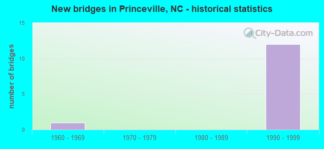
- New bridges - historical statistics
- 11960-1969
- 121990-1999


- Bridge Condition - Deck
- 33.3%Good
- 66.7%Satisfactory

- Bridge Condition - Superstructure
- 16.7%Very good
- 66.7%Good
- 16.7%Satisfactory

- Bridge Condition - Substructure
- 16.7%Very good
- 66.7%Good
- 16.7%Satisfactory

- Bridge Condition - Channel
- 50.0%Good
- 50.0%Satisfactory
Find on map >> Show street view
Structure Number: 650117, Location: 300'. N. OF JCT. US64 (Lat: 35.862392, Lng: -77.504422), Route carried "on" structure: State highway 1523, Year Built: 1963, Status: Posted for load, Structure Length: 0.67m (2.20ft), Average Daily Traffic: 210 (year 2016), Truck Traffic: 6%, Average Future Daily Traffic: 420 (year 2040), Features Intersected: CROMWELL CANAL
Minimum Vertical Clearance: 30+ m (98+ ft), Kilometerpoint: 0.000, Lanes on structure: 2, Owner: State Highway Agency, Approaching Roadway Width: 6.4m (21.0ft), Skew: 3 degrees, Material/Design: Steel, Design/Construction: Stringer/Multi-beam, Number Of Spans In Main Unit: 1, Length of Maximum Span: 6.0m (19.7ft), Curb or Sidewalk Widths: Left: 0.2m (0.7ft), Right: 0.2m (0.7ft), Curb-To-Curb Width: 7.3m (24.0ft), Out-to-Out Width: 7.7m (25.3ft)
Condition: Deck: Satisfactory, Superstructure: Satisfactory, Substructure: Satisfactory, Channel: Good, Operating Rating: 43.5 metric tons, Method Used To Determine Operating Rating: Load Factor (LF), Inventory Rating: 26.3 metric tons, Method Used To Determine Inventory Rating: Load Factor (LF), Structural Evaluation: Equal to present minimum criteria, Deck Geometry: Somewhat better than minimum adequacy, Waterway Adequacy: Better than present minimum criteria, Approach Roadway Alignment: Equal to present desirable criteria, Designated Inspection Frequency: Every 24 months, Inspection Date: October 2020, Deck Structure Type: Concrete Cast-file-Place, Wearing Surface/Protective System: Wearing Surface: Bituminous
Find on map >> Show street view
Structure Number: 650325, Location: 1.2 MI.E. OF JCT.US258 (Lat: 35.870486, Lng: -77.523658), Route carried "on" structure: US 64, Year Built: 1997, Status: Open, Structure Length: 4.02m (13.19ft), Average Daily Traffic: 7,750 (year 2018), Truck Traffic: 12%, Average Future Daily Traffic: 15,500 (year 2040), Design Load: HS 20+Mod, Features Intersected: NC33
Minimum Vertical Clearance: 30+ m (98+ ft), Kilometerpoint: 148.439, Lanes on structure: 2, Lanes under structure: 3, Base Highway Network: Yes (Inventory Route: 2, Subroute: 64), Owner: State Highway Agency, Approaching Roadway Width: 10.9m (35.8ft), Skew: 12 degrees, Material/Design: Prestressed concrete continuous, Design/Construction: Stringer/Multi-beam, Number Of Spans In Main Unit: 3, Length of Maximum Span: 21.3m (69.9ft), Curb-To-Curb Width: 11.5m (37.7ft), Out-to-Out Width: 12.5m (41.0ft)
Condition: Deck: Good, Superstructure: Good, Substructure: Good, Operating Rating: 87.0 metric tons, Method Used To Determine Operating Rating: Load Factor (LF), Inventory Rating: 42.6 metric tons, Method Used To Determine Inventory Rating: Load Factor (LF), Structural Evaluation: Better than present minimum criteria, Deck Geometry: Somewhat better than minimum adequacy, Underclear: Equal to present minimum criteria, Approach Roadway Alignment: Equal to present desirable criteria, Designated Inspection Frequency: Every 24 months, Inspection Date: November 2020, Deck Structure Type: Concrete Cast-file-Place, Wearing Surface/Protective System: Wearing Surface: Monolithic Concrete, Deck Protection: Epoxy Coated Reinforcing
Find on map >> Show street view
Structure Number: 650326, Location: 1.2 MI. E. JCT. US258 (Lat: 35.870753, Lng: -77.523597), Route carried "on" structure: US 64, Year Built: 1997, Status: Open, Structure Length: 4.02m (13.19ft), Average Daily Traffic: 7,750 (year 2018), Truck Traffic: 12%, Average Future Daily Traffic: 15,500 (year 2040), Design Load: HS 20+Mod, Features Intersected: NC33
Minimum Vertical Clearance: 30+ m (98+ ft), Kilometerpoint: 148.439, Lanes on structure: 2, Lanes under structure: 3, Base Highway Network: Yes (Inventory Route: 2, Subroute: 64), Owner: State Highway Agency, Approaching Roadway Width: 11.5m (37.7ft), Skew: 12 degrees, Material/Design: Prestressed concrete continuous, Design/Construction: Stringer/Multi-beam, Number Of Spans In Main Unit: 3, Length of Maximum Span: 21.3m (69.9ft), Curb-To-Curb Width: 11.5m (37.7ft), Out-to-Out Width: 12.5m (41.0ft)
Condition: Deck: Satisfactory, Superstructure: Very good, Substructure: Good, Operating Rating: 87.9 metric tons, Method Used To Determine Operating Rating: Load Factor (LF), Inventory Rating: 43.5 metric tons, Method Used To Determine Inventory Rating: Load Factor (LF), Structural Evaluation: Better than present minimum criteria, Deck Geometry: Somewhat better than minimum adequacy, Underclear: Somewhat better than minimum adequacy, Approach Roadway Alignment: Equal to present desirable criteria, Designated Inspection Frequency: Every 24 months, Inspection Date: Febuary 2021, Deck Structure Type: Concrete Cast-file-Place, Wearing Surface/Protective System: Wearing Surface: Monolithic Concrete, Deck Protection: Epoxy Coated Reinforcing
Find on map >> Show street view
Structure Number: 650327, Location: 0.9 MI.E.JCT.NC33 (Lat: 35.866131, Lng: -77.509722), Route carried "on" structure: US 64, Year Built: 1997, Status: Open, Structure Length: 6.91m (22.67ft), Average Daily Traffic: 7,750 (year 2018), Truck Traffic: 12%, Average Future Daily Traffic: 15,500 (year 2040), Design Load: HS 20+Mod, Features Intersected: US64ALT&CSXRR
Minimum Vertical Clearance: 30+ m (98+ ft), Kilometerpoint: 42.352, Lanes on structure: 2, Lanes under structure: 2, Base Highway Network: Yes (Inventory Route: 2, Subroute: 64), Owner: State Highway Agency, Approaching Roadway Width: 11.5m (37.7ft), Skew: 12 degrees, Material/Design: Prestressed concrete continuous, Design/Construction: Stringer/Multi-beam, Number Of Spans In Main Unit: 4, Number Of Approach Spans: 2, Length of Maximum Span: 21.0m (68.9ft), Curb-To-Curb Width: 11.5m (37.7ft), Out-to-Out Width: 12.5m (41.0ft)
Condition: Deck: Satisfactory, Superstructure: Good, Substructure: Very good, Operating Rating: 63.5 metric tons, Method Used To Determine Operating Rating: Load Factor (LF), Inventory Rating: 38.1 metric tons, Method Used To Determine Inventory Rating: Load Factor (LF), Structural Evaluation: Better than present minimum criteria, Deck Geometry: Somewhat better than minimum adequacy, Underclear: Somewhat better than minimum adequacy, Approach Roadway Alignment: Equal to present desirable criteria, Designated Inspection Frequency: Every 24 months, Inspection Date: Febuary 2021, Deck Structure Type: Concrete Cast-file-Place, Wearing Surface/Protective System: Wearing Surface: Monolithic Concrete, Deck Protection: Epoxy Coated Reinforcing
Find on map >> Show street view
Structure Number: 650328, Location: 0.9 MI.E.JCT.NC33 (Lat: 35.866314, Lng: -77.509919), Route carried "on" structure: US 64, Year Built: 1997, Status: Open, Structure Length: 6.70m (21.98ft), Average Daily Traffic: 7,750 (year 2018), Truck Traffic: 12%, Average Future Daily Traffic: 15,500 (year 2040), Design Load: HS 20+Mod, Features Intersected: US64ALT & CSXRR
Minimum Vertical Clearance: 30+ m (98+ ft), Kilometerpoint: 42.352, Lanes on structure: 2, Lanes under structure: 2, Base Highway Network: Yes (Inventory Route: 2, Subroute: 64), Owner: State Highway Agency, Approaching Roadway Width: 11.2m (36.7ft), Skew: 12 degrees, Material/Design: Prestressed concrete continuous, Design/Construction: Stringer/Multi-beam, Number Of Spans In Main Unit: 4, Length of Maximum Span: 21.3m (69.9ft), Curb-To-Curb Width: 11.5m (37.7ft), Out-to-Out Width: 12.5m (41.0ft)
Condition: Deck: Satisfactory, Superstructure: Good, Substructure: Good, Operating Rating: 79.8 metric tons, Method Used To Determine Operating Rating: Load Factor (LF), Inventory Rating: 44.4 metric tons, Method Used To Determine Inventory Rating: Load Factor (LF), Structural Evaluation: Better than present minimum criteria, Deck Geometry: Somewhat better than minimum adequacy, Underclear: Somewhat better than minimum adequacy, Approach Roadway Alignment: Equal to present desirable criteria, Designated Inspection Frequency: Every 24 months, Inspection Date: Febuary 2021, Deck Structure Type: Concrete Cast-file-Place, Wearing Surface/Protective System: Wearing Surface: Monolithic Concrete, Deck Protection: Epoxy Coated Reinforcing
Find on map >> Show street view
Structure Number: 650329, Location: 0.6 MI.E.JCT.NC33 (Lat: 35.865714, Lng: -77.514275), Route carried "on" structure: US 9901, Year Built: 1997, Status: Open, Structure Length: 0.70m (2.30ft), Average Daily Traffic: 7,750 (year 2018), Truck Traffic: 14%, Average Future Daily Traffic: 15,500 (year 2040), Design Load: HS 20+Mod, Features Intersected: BR. OF CROMWELL CAN., Facility Carried by Structure: US64
Minimum Vertical Clearance: 30+ m (98+ ft), Kilometerpoint: 148.591, Lanes on structure: 2, Base Highway Network: Yes (Inventory Route: 2, Subroute: 64), Owner: State Highway Agency, Approaching Roadway Width: 24.3m (79.7ft), Material/Design: Concrete continuous, Design/Construction: Culvert, Number Of Spans In Main Unit: 3, Length of Maximum Span: 2.1m (6.9ft)
Condition: Channel: Satisfactory, Culverts: Good, Operating Rating: 89.8 metric tons, Method Used To Determine Operating Rating: Load and Resistance Factor (LRFR), Inventory Rating: 89.8 metric tons, Method Used To Determine Inventory Rating: Load and Resistance Factor (LRFR), Structural Evaluation: Better than present minimum criteria, Waterway Adequacy: Better than present minimum criteria, Approach Roadway Alignment: Equal to present desirable criteria, Designated Inspection Frequency: Every 24 months, Underwater Inspection Frequency: Every 60 months, Inspection Date: November 2020, Underwater Inspection Date: November 2020
Find on map >> Show street view
Structure Number: 65033, Location: 0.4MI. N. OF JCT US64 ALT (Lat: 35.869336, Lng: -77.501939), Route carried "on" structure: State highway 1523, Year Built: 1998, Status: Open, Structure Length: 6.00m (19.69ft), Average Daily Traffic: 910 (year 2018), Truck Traffic: 6%, Average Future Daily Traffic: 1,820 (year 2040), Design Load: HS 20+Mod, Features Intersected: US64
Minimum Vertical Clearance: 30+ m (98+ ft), Kilometerpoint: 148.744, Lanes on structure: 2, Lanes under structure: 4, Owner: State Highway Agency, Approaching Roadway Width: 13.7m (44.9ft), Material/Design: Prestressed concrete continuous, Design/Construction: Stringer/Multi-beam, Number Of Spans In Main Unit: 4, Length of Maximum Span: 20.7m (67.9ft), Curb-To-Curb Width: 14.6m (47.9ft), Out-to-Out Width: 15.5m (50.9ft)
Condition: Deck: Good, Superstructure: Good, Substructure: Good, Operating Rating: 87.9 metric tons, Method Used To Determine Operating Rating: Load Factor (LF), Inventory Rating: 45.3 metric tons, Method Used To Determine Inventory Rating: Load Factor (LF), Structural Evaluation: Better than present minimum criteria, Deck Geometry: Superior to present desirable criteria, Underclear: Somewhat better than minimum adequacy, Approach Roadway Alignment: Equal to present desirable criteria, Designated Inspection Frequency: Every 24 months, Inspection Date: November 2020, Deck Structure Type: Concrete Cast-file-Place, Wearing Surface/Protective System: Wearing Surface: Monolithic Concrete
Find on map >> Show street view
Structure Number: 650325, Location: 1.2 MI.E. OF JCT.US258 (Lat: 35.870486, Lng: -77.523658), Route carried "under" structure: State highway 33, Year Built: 1997, Structure Length: 0. m, Average Daily Traffic: 3,800 (year 2019), Truck Traffic: 7%, Features Intersected: US64EBL
Minimum Vertical Clearance: 5.23m (17.16ft), Kilometerpoint: 0.000, Lanes on structure: 2, Lanes under structure: 3, Material/Design: Prestressed concrete continuous, Design/Construction: Stringer/Multi-beam, Length of Maximum Span: 21.3m (69.9ft)
Find on map >> Show street view
Structure Number: 650326, Location: 1.2 MI. E. JCT. US258 (Lat: 35.870753, Lng: -77.523597), Route carried "under" structure: State highway 33, Year Built: 1997, Structure Length: 0. m, Average Daily Traffic: 3,800 (year 2019), Truck Traffic: 6%, Features Intersected: US64 WBL
Minimum Vertical Clearance: 5.23m (17.16ft), Kilometerpoint: 0.000, Lanes on structure: 2, Lanes under structure: 3, Material/Design: Prestressed concrete continuous, Design/Construction: Stringer/Multi-beam, Length of Maximum Span: 21.3m (69.9ft)
Find on map >> Show street view
Structure Number: 650327, Location: 0.9 MI.E.JCT.NC33 (Lat: 35.866131, Lng: -77.509722), Route carried "under" structure: Alternate US 64, Year Built: 1997, Structure Length: 0. m, Average Daily Traffic: 1,700 (year 2019), Truck Traffic: 12%, Features Intersected: US64 EBL
Minimum Vertical Clearance: 8.40m (27.56ft), Kilometerpoint: 0.000, Lanes on structure: 2, Lanes under structure: 2, Material/Design: Prestressed concrete continuous, Design/Construction: Stringer/Multi-beam, Length of Maximum Span: 21.0m (68.9ft)
Find on map >> Show street view
Structure Number: 650328, Location: 0.9 MI.E.JCT.NC33 (Lat: 35.866314, Lng: -77.509919), Route carried "under" structure: Alternate US 64, Year Built: 1997, Structure Length: 0. m, Average Daily Traffic: 1,700 (year 2017), Truck Traffic: 12%, Features Intersected: US64W
Minimum Vertical Clearance: 7.74m (25.39ft), Kilometerpoint: 42.352, Lanes on structure: 2, Lanes under structure: 2, Material/Design: Prestressed concrete continuous, Design/Construction: Stringer/Multi-beam, Length of Maximum Span: 21.3m (69.9ft)
Find on map >> Show street view
Structure Number: 65033, Location: 0.4MI. N. OF JCT US64 ALT (Lat: 35.869336, Lng: -77.501939), Route carried "under" structure: US 64, Year Built: 1998, Structure Length: 0. m, Average Daily Traffic: 7,750 (year 2018), Truck Traffic: 14%, Features Intersected: SR1523
Minimum Vertical Clearance: 5.33m (17.49ft), Kilometerpoint: 148.774, Lanes on structure: 2, Lanes under structure: 2, Material/Design: Prestressed concrete continuous, Design/Construction: Stringer/Multi-beam, Length of Maximum Span: 20.7m (67.9ft)
Find on map >> Show street view
Structure Number: 65033, Location: 0.4MI. N. OF JCT US64 ALT (Lat: 35.869336, Lng: -77.501939), Route carried "under" structure: US 64, Year Built: 1998, Structure Length: 0. m, Average Daily Traffic: 7,750 (year 2018), Truck Traffic: 14%, Features Intersected: SR1523
Minimum Vertical Clearance: 5.63m (18.47ft), Kilometerpoint: 148.774, Lanes on structure: 2, Lanes under structure: 2, Material/Design: Prestressed concrete continuous, Design/Construction: Stringer/Multi-beam, Length of Maximum Span: 20.7m (67.9ft)