Bridge Statistics for Pylesville, Maryland (MD)
Condition, Traffic, Stress, Structural Evaluation, Project Costs
- National Bridge Inventory (NBI) Statistics
- 21Number of bridges
- 157ft / 47.7mTotal length
- $3,450,000Total costs
- 34,462Total average daily traffic
- 2,579Total average daily truck traffic
- 41,222Total future (year 2026) average daily traffic
- National Bridge Inventory (NBI) Registered Bridges for Pylesville
- No street view available for this location
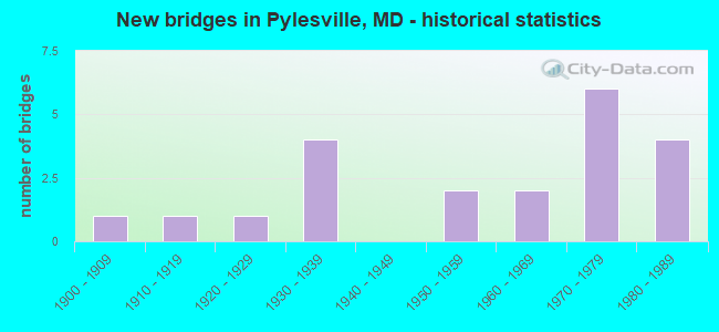
- New bridges - historical statistics
- 11900-1909
- 11910-1919
- 11920-1929
- 41930-1939
- 21950-1959
- 21960-1969
- 61970-1979
- 41980-1989

- Reconstructed bridges - Historical Statistics
- 11950-1959
- 01960-1969
- 01970-1979
- 21980-1989
- 31990-1999
- 12000-2009
- 12010-2019


- Bridge Condition - Deck
- 6.7%Very good
- 53.3%Good
- 26.7%Satisfactory
- 6.7%Fair
- 6.7%Poor

- Bridge Condition - Superstructure
- 5.9%Very good
- 35.3%Good
- 35.3%Satisfactory
- 23.5%Fair

- Bridge Condition - Substructure
- 52.9%Good
- 41.2%Satisfactory
- 5.9%Fair

- Bridge Condition - Channel
- 14.3%Very good
- 33.3%Good
- 52.4%Satisfactory

- Bridge Condition - Culverts
- 25.0%Good
- 50.0%Satisfactory
- 25.0%Fair
Find on map >> Show street view
Structure Number: 10000012001601, Location: 2.17 MILES S OF MD 165 (Lat: 39.641644, Lng: -76.412314), Route carried "on" structure: State highway 24, Year Built: 1934, Year Reconstructed: 2001, Status: Open, Structure Length: 4.02m (13.19ft), Average Daily Traffic: 3,930 (year 2020), Truck Traffic: 8%, Average Future Daily Traffic: 4,796 (year 2040), Design Load: HS 20, Features Intersected: DEER CREEK
Minimum Vertical Clearance: 4.27m (14.01ft), Kilometerpoint: 30.362, Lanes on structure: 2, Owner: State Highway Agency, Approaching Roadway Width: 8.5m (27.9ft), Skew: 5 degrees, Material/Design: Steel, Design/Construction: Truss - Thru, Number Of Spans In Main Unit: 1, Length of Maximum Span: 37.5m (123.0ft), Curb-To-Curb Width: 8.7m (28.5ft), Out-to-Out Width: 9.6m (31.5ft)
Condition: Deck: Good, Superstructure: Satisfactory, Substructure: Satisfactory, Channel: Good, Operating Rating: 43.5 metric tons, Method Used To Determine Operating Rating: Load Factor (LF), Inventory Rating: 36.3 metric tons, Method Used To Determine Inventory Rating: Load Factor (LF), Structural Evaluation: Equal to present minimum criteria, Deck Geometry: Meets minimum limits, Waterway Adequacy: Superior to present desirable criteria, Approach Roadway Alignment: Equal to present desirable criteria, Length Of Structure Improvement: 4.02m (13.19ft), Designated Inspection Frequency: Every 24 months, Critical Feature Inspection Frequency: Every 24 months, Inspection Date: March 2020, Critical Feature Inspection Date: March 2020, Bridge Improvement Cost: $249,000, Roadway Improvement Cost: $25,000, Total Project Cost: $274,000, Deck Structure Type: Other, Wearing Surface/Protective System: Wearing Surface: Bituminous
Find on map >> Show street view
Structure Number: 10000012001701, Location: 2.86 MILES S OF MD 165 (Lat: 39.632089, Lng: -76.411064), Route carried "on" structure: State highway 24, Year Built: 1917, Year Reconstructed: 1993, Status: Open, Structure Length: 0.76m (2.49ft), Average Daily Traffic: 3,193 (year 2013), Truck Traffic: 8%, Average Future Daily Traffic: 4,061 (year 2026), Features Intersected: KELLOGG BRANCH
Minimum Vertical Clearance: 30+ m (98+ ft), Kilometerpoint: 29.252, Lanes on structure: 2, Owner: State Highway Agency, Approaching Roadway Width: 7.0m (23.0ft), Skew: 1 degrees, Material/Design: Concrete, Design/Construction: Tee Beam, Number Of Spans In Main Unit: 1, Length of Maximum Span: 6.4m (21.0ft), Curb-To-Curb Width: 9.0m (29.5ft), Out-to-Out Width: 9.8m (32.2ft)
Condition: Deck: Satisfactory, Superstructure: Good, Substructure: Good, Channel: Very good, Inventory Rating: 60.3 metric tons, Method Used To Determine Inventory Rating: Load Factor (LF), Structural Evaluation: Better than present minimum criteria, Deck Geometry: Meets minimum limits, Waterway Adequacy: Superior to present desirable criteria, Approach Roadway Alignment: Equal to present desirable criteria, Length Of Structure Improvement: 0.76m (2.49ft), Designated Inspection Frequency: Every 24 months, Inspection Date: September 2021, Bridge Improvement Cost: $50,000, Roadway Improvement Cost: $5,000, Total Project Cost: $55,000, Deck Structure Type: Concrete Cast-file-Place, Wearing Surface/Protective System: Wearing Surface: Bituminous, Deck Protection: Epoxy Coated Reinforcing
Find on map >> Show street view
Structure Number: 10000012003101, Location: 0.55 MILE NORTH OF MD 24 (Lat: 39.696439, Lng: -76.427564), Route carried "on" structure: State highway 136, Year Built: 1931, Status: Open, Structure Length: 1.46m (4.79ft), Average Daily Traffic: 2,161 (year 2009), Truck Traffic: 8%, Average Future Daily Traffic: 2,480 (year 2026), Features Intersected: FALLING BRANCH
Minimum Vertical Clearance: 30+ m (98+ ft), Kilometerpoint: 39.099, Lanes on structure: 2, Owner: State Highway Agency, Approaching Roadway Width: 7.3m (24.0ft), Skew: 4 degrees, Material/Design: Concrete, Design/Construction: Tee Beam, Number Of Spans In Main Unit: 1, Length of Maximum Span: 11.6m (38.1ft), Curb-To-Curb Width: 8.3m (27.2ft), Out-to-Out Width: 9.5m (31.2ft)
Condition: Deck: Satisfactory, Superstructure: Fair, Substructure: Fair, Channel: Satisfactory, Operating Rating: 82.5 metric tons, Method Used To Determine Operating Rating: Load Factor (LF), Inventory Rating: 49.4 metric tons, Method Used To Determine Inventory Rating: Load Factor (LF), Structural Evaluation: Somewhat better than minimum adequacy, Deck Geometry: High priority of corrective action, Waterway Adequacy: Superior to present desirable criteria, Approach Roadway Alignment: Equal to present desirable criteria, Length Of Structure Improvement: 1.46m (4.79ft), Designated Inspection Frequency: Every 24 months, Inspection Date: Febuary 2020, Bridge Improvement Cost: $90,000, Roadway Improvement Cost: $9,000, Total Project Cost: $99,000, Deck Structure Type: Concrete Cast-file-Place, Wearing Surface/Protective System: Wearing Surface: Monolithic Concrete
Find on map >> Show street view
Structure Number: 10000012004301, Location: 1.89 MILES SOUTH OF MD 24 (Lat: 39.665961, Lng: -76.441972), Route carried "on" structure: State highway 165, Year Built: 1932, Year Reconstructed: 1985, Status: Open, Structure Length: 2.62m (8.60ft), Average Daily Traffic: 6,101 (year 2009), Truck Traffic: 8%, Average Future Daily Traffic: 6,596 (year 2026), Design Load: HS 20, Features Intersected: DEER CREEK
Minimum Vertical Clearance: 30+ m (98+ ft), Kilometerpoint: 19.051, Lanes on structure: 2, Base Highway Network: Yes, Owner: State Highway Agency, Approaching Roadway Width: 12.2m (40.0ft), Material/Design: Steel, Design/Construction: Stringer/Multi-beam, Number Of Spans In Main Unit: 1, Length of Maximum Span: 24.4m (80.1ft), Curb-To-Curb Width: 7.9m (25.9ft), Out-to-Out Width: 8.9m (29.2ft)
Condition: Deck: Good, Superstructure: Satisfactory, Substructure: Satisfactory, Channel: Very good, Inventory Rating: 61.7 metric tons, Method Used To Determine Inventory Rating: Load Factor (LF), Structural Evaluation: Equal to present minimum criteria, Deck Geometry: High priority of replacement, Waterway Adequacy: Equal to present minimum criteria, Approach Roadway Alignment: Equal to present desirable criteria, Length Of Structure Improvement: 2.62m (8.60ft), Designated Inspection Frequency: Every 24 months, Inspection Date: December 2021, Bridge Improvement Cost: $150,000, Roadway Improvement Cost: $15,000, Total Project Cost: $165,000, Deck Structure Type: Concrete Cast-file-Place, Wearing Surface/Protective System: Wearing Surface: Monolithic Concrete, Deck Protection: Epoxy Coated Reinforcing
Find on map >> Show street view
Structure Number: 10000012005401, Location: 1.15 MILES N OF MD 165 (Lat: 39.696189, Lng: -76.390208), Route carried "on" structure: State highway 624, Year Built: 1936, Year Reconstructed: 1959, Status: Open, Structure Length: 0.76m (2.49ft), Average Daily Traffic: 3,920 (year 2009), Truck Traffic: 8%, Average Future Daily Traffic: 4,059 (year 2026), Design Load: H 20, Features Intersected: BROAD CREEK
Minimum Vertical Clearance: 30+ m (98+ ft), Kilometerpoint: 1.850, Lanes on structure: 2, Owner: State Highway Agency, Approaching Roadway Width: 7.3m (24.0ft), Skew: 2 degrees, Material/Design: Steel, Design/Construction: Stringer/Multi-beam, Number Of Spans In Main Unit: 1, Length of Maximum Span: 7.3m (24.0ft), Curb-To-Curb Width: 9.1m (29.9ft), Out-to-Out Width: 9.6m (31.5ft)
Condition: Deck: Satisfactory, Superstructure: Fair, Substructure: Satisfactory, Channel: Satisfactory, Operating Rating: 44.4 metric tons, Method Used To Determine Operating Rating: Load Factor (LF), Inventory Rating: 26.8 metric tons, Method Used To Determine Inventory Rating: Load Factor (LF), Structural Evaluation: Somewhat better than minimum adequacy, Deck Geometry: Meets minimum limits, Waterway Adequacy: Superior to present desirable criteria, Approach Roadway Alignment: Equal to present desirable criteria, Length Of Structure Improvement: 0.76m (2.49ft), Designated Inspection Frequency: Every 12 months, Inspection Date: June 2021, Bridge Improvement Cost: $47,000, Roadway Improvement Cost: $5,000, Total Project Cost: $52,000, Deck Structure Type: Concrete Cast-file-Place, Wearing Surface/Protective System: Wearing Surface: Monolithic Concrete
Find on map >> Show street view
Structure Number: 10000012007803, Location: 0.29 M S OF COEN ROAD (Lat: 39.646614, Lng: -76.410189), Route carried "on" structure: State highway 24, Year Built: 1986, Status: Open, Structure Length: 0.69m (2.26ft), Average Daily Traffic: 3,193 (year 2013), Truck Traffic: 8%, Average Future Daily Traffic: 4,061 (year 2026), Design Load: HS 20, Features Intersected: BR OF DEER CREEK
Minimum Vertical Clearance: 30+ m (98+ ft), Kilometerpoint: 30.957, Lanes on structure: 2, Owner: State Highway Agency, Approaching Roadway Width: 8.5m (27.9ft), Material/Design: Steel, Design/Construction: Culvert, Length of Maximum Span: 3.0m (9.8ft)
Condition: Channel: Satisfactory, Culverts: Good, Structural Evaluation: Better than present minimum criteria, Waterway Adequacy: Equal to present desirable criteria, Approach Roadway Alignment: Equal to present minimum criteria, Designated Inspection Frequency: Every 24 months, Inspection Date: September 2021
Find on map >> Show street view
Structure Number: 10000012007903, Location: 0.09 M N OF COEN ROAD (Lat: 39.657311, Lng: -76.407981), Route carried "on" structure: State highway 24, Year Built: 1986, Status: Open, Structure Length: 0.96m (3.15ft), Average Daily Traffic: 3,193 (year 2013), Truck Traffic: 8%, Average Future Daily Traffic: 4,061 (year 2026), Design Load: HS 20, Features Intersected: BR OF DEER CREEK
Minimum Vertical Clearance: 30+ m (98+ ft), Kilometerpoint: 31.467, Lanes on structure: 2, Owner: State Highway Agency, Approaching Roadway Width: 8.5m (27.9ft), Skew: 4 degrees, Material/Design: Steel, Design/Construction: Culvert, Length of Maximum Span: 4.3m (14.1ft)
Condition: Channel: Satisfactory, Culverts: Satisfactory, Operating Rating: 88.9 metric tons, Method Used To Determine Operating Rating: Load Factor (LF), Inventory Rating: 53.1 metric tons, Method Used To Determine Inventory Rating: Load Factor (LF), Structural Evaluation: Equal to present minimum criteria, Waterway Adequacy: Equal to present desirable criteria, Approach Roadway Alignment: Equal to present minimum criteria, Designated Inspection Frequency: Every 24 months, Inspection Date: January 2021
Find on map >> Show street view
Structure Number: 10000012008003, Location: 0.02 M S OF DAVIS ROAD (Lat: 39.651339, Lng: -76.410239), Route carried "on" structure: State highway 24, Year Built: 1986, Status: Open, Structure Length: 1.51m (4.95ft), Average Daily Traffic: 3,193 (year 2013), Truck Traffic: 8%, Average Future Daily Traffic: 4,061 (year 2026), Design Load: HS 20, Features Intersected: BR OF DEER CREEK
Minimum Vertical Clearance: 30+ m (98+ ft), Kilometerpoint: 32.196, Lanes on structure: 2, Owner: State Highway Agency, Approaching Roadway Width: 8.5m (27.9ft), Skew: 6 degrees, Material/Design: Steel, Design/Construction: Culvert, Length of Maximum Span: 6.4m (21.0ft)
Condition: Channel: Satisfactory, Culverts: Fair, Operating Rating: 62.6 metric tons, Method Used To Determine Operating Rating: Load Factor (LF), Inventory Rating: 37.6 metric tons, Method Used To Determine Inventory Rating: Load Factor (LF), Structural Evaluation: Somewhat better than minimum adequacy, Waterway Adequacy: Equal to present desirable criteria, Approach Roadway Alignment: Equal to present desirable criteria, Designated Inspection Frequency: Every 12 months, Inspection Date: December 2021
Find on map >> Show street view
Structure Number: 200000H-004301, Location: 1.0 MILE S OF CHERRY H RD (Lat: 39.628817, Lng: -76.375256), Route carried "on" structure: County highway 87, Year Built: 1955, Status: Posted for load, Structure Length: 5.06m (16.60ft), Average Daily Traffic: 1,660 (year 2019), Truck Traffic: 5%, Average Future Daily Traffic: 2,030 (year 2039), Design Load: H 20, Features Intersected: DEER CREEK, Facility Carried by Structure: GRIER NURSERY ROAD
Minimum Vertical Clearance: 30+ m (98+ ft), Kilometerpoint: 6.146, Lanes on structure: 2, Owner: County Highway Agency, Approaching Roadway Width: 6.7m (22.0ft), Skew: 4 degrees, Material/Design: Steel continuous, Design/Construction: Stringer/Multi-beam, Number Of Spans In Main Unit: 3, Length of Maximum Span: 18.3m (60.0ft), Curb or Sidewalk Widths: Left: 0.5m (1.6ft), Right: 0.5m (1.6ft), Curb-To-Curb Width: 6.7m (22.0ft), Out-to-Out Width: 8.4m (27.6ft)
Condition: Deck: Poor, Superstructure: Good, Substructure: Satisfactory, Channel: Good, Operating Rating: 40.8 metric tons, Method Used To Determine Operating Rating: Load Factor (LF), Inventory Rating: 24.5 metric tons, Method Used To Determine Inventory Rating: Load Factor (LF), Structural Evaluation: Equal to present minimum criteria, Deck Geometry: High priority of corrective action, Waterway Adequacy: Superior to present desirable criteria, Approach Roadway Alignment: Better than present minimum criteria, Length Of Structure Improvement: 5.06m (16.60ft), Designated Inspection Frequency: Every 24 months, Inspection Date: September 2021, Bridge Improvement Cost: $450,000, Roadway Improvement Cost: $45,000, Total Project Cost: $495,000, Deck Structure Type: Concrete Cast-file-Place, Wearing Surface/Protective System: Wearing Surface: Bituminous
Find on map >> Show street view
Structure Number: 200000H-009401, Location: 0.02 MILES NE OF MD 24 (Lat: 39.629894, Lng: -76.398128), Route carried "on" structure: County highway 120, Year Built: 1900, Year Reconstructed: 1999, Status: Posted for load, Structure Length: 3.78m (12.40ft), Average Daily Traffic: 559 (year 2020), Truck Traffic: 5%, Average Future Daily Traffic: 657 (year 2040), Design Load: H 15, Features Intersected: DEER CREEK, Facility Carried by Structure: CHERRY HILL ROAD
Minimum Vertical Clearance: 3.66m (12.01ft), Kilometerpoint: 6.388, Lanes on structure: 1, Owner: County Highway Agency, Approaching Roadway Width: 4.3m (14.1ft), Material/Design: Steel, Design/Construction: Truss - Thru, Number Of Spans In Main Unit: 1, Length of Maximum Span: 35.7m (117.1ft), Curb-To-Curb Width: 3.8m (12.5ft), Out-to-Out Width: 4.4m (14.4ft)
Condition: Deck: Good, Superstructure: Fair, Substructure: Good, Channel: Good, Operating Rating: 16.3 metric tons, Method Used To Determine Operating Rating: Load Factor (LF), Inventory Rating: 10.9 metric tons, Method Used To Determine Inventory Rating: Load Factor (LF), Structural Evaluation: High priority of replacement, Deck Geometry: High priority of replacement, Waterway Adequacy: Superior to present desirable criteria, Approach Roadway Alignment: Meets minimum limits, Bridge Posting: Required (Relationship of Operating Rating to Maximum Legal Load: 30.0 - 39.9% below), Length Of Structure Improvement: 3.66m (12.01ft), Designated Inspection Frequency: Every 24 months, Critical Feature Inspection Frequency: Every 24 months, Other Special Inspection Frequency: Every 12 months, Inspection Date: November 2021, Critical Feature Inspection Date: November 2021, Other Special Inspection Date: November 2021, Bridge Improvement Cost: $1,800,000, Roadway Improvement Cost: $180,000, Total Project Cost: $1,980,000, Deck Structure Type: Wood or Timber, Wearing Surface/Protective System: Wearing Surface: Wood or Timber, Deck Protection: Other
Find on map >> Show street view
Structure Number: 200000H-009901, Location: 1.7 MILES S OF MD 165 (Lat: 39.645181, Lng: -76.427478), Route carried "on" structure: County highway 82, Year Built: 1961, Year Reconstructed: 2012, Status: Open, Structure Length: 5.54m (18.18ft), Average Daily Traffic: 390 (year 2019), Truck Traffic: 5%, Average Future Daily Traffic: 687 (year 2039), Features Intersected: DEER CREEK, Facility Carried by Structure: ST CLAIR BRIDGE RD
Minimum Vertical Clearance: 30+ m (98+ ft), Kilometerpoint: 2.800, Lanes on structure: 2, Owner: County Highway Agency, Approaching Roadway Width: 6.1m (20.0ft), Skew: 1 degrees, Material/Design: Steel, Design/Construction: Stringer/Multi-beam, Number Of Spans In Main Unit: 3, Length of Maximum Span: 21.0m (68.9ft), Curb-To-Curb Width: 7.9m (25.9ft), Out-to-Out Width: 8.8m (28.9ft)
Condition: Deck: Very good, Superstructure: Satisfactory, Substructure: Good, Channel: Very good, Operating Rating: 84.4 metric tons, Method Used To Determine Operating Rating: Load Factor (LF), Inventory Rating: 50.3 metric tons, Method Used To Determine Inventory Rating: Load Factor (LF), Structural Evaluation: Equal to present minimum criteria, Deck Geometry: Somewhat better than minimum adequacy, Waterway Adequacy: Superior to present desirable criteria, Approach Roadway Alignment: Equal to present minimum criteria, Designated Inspection Frequency: Every 24 months, Inspection Date: September 2021, Deck Structure Type: Concrete Cast-file-Place, Wearing Surface/Protective System: Wearing Surface: Monolithic Concrete
Find on map >> Show street view
Structure Number: 200000H-010901, Location: 0.8 MILES N OF MD 165 (Lat: 39.675056, Lng: -76.448250), Route carried "on" structure: County highway 93, Year Built: 1978, Status: Open, Structure Length: 2.59m (8.50ft), Average Daily Traffic: 978 (year 2021), Truck Traffic: 5%, Average Future Daily Traffic: 1,194 (year 2041), Design Load: HS 20, Features Intersected: DEER CREEK, Facility Carried by Structure: FAWN GROVE ROAD
Minimum Vertical Clearance: 30+ m (98+ ft), Kilometerpoint: 1.287, Lanes on structure: 2, Owner: County Highway Agency, Approaching Roadway Width: 9.1m (29.9ft), Material/Design: Steel, Design/Construction: Stringer/Multi-beam, Number Of Spans In Main Unit: 1, Length of Maximum Span: 24.4m (80.1ft), Curb-To-Curb Width: 9.1m (29.9ft), Out-to-Out Width: 10.1m (33.1ft)
Condition: Deck: Good, Superstructure: Good, Substructure: Good, Channel: Good, Inventory Rating: 66.7 metric tons, Method Used To Determine Inventory Rating: Load Factor (LF), Structural Evaluation: Better than present minimum criteria, Deck Geometry: Equal to present minimum criteria, Waterway Adequacy: Equal to present desirable criteria, Approach Roadway Alignment: Equal to present minimum criteria, Designated Inspection Frequency: Every 24 months, Inspection Date: July 2021, Deck Structure Type: Concrete Cast-file-Place, Wearing Surface/Protective System: Wearing Surface: Monolithic Concrete
Find on map >> Show street view
Structure Number: 200000H-011003, Location: 0.3 MILES E OF FAWN GR RD (Lat: 39.675031, Lng: -76.443211), Route carried "on" structure: County highway 91, Year Built: 1975, Status: Open, Structure Length: 0.79m (2.59ft), Average Daily Traffic: 113 (year 2020), Truck Traffic: 5%, Average Future Daily Traffic: 184 (year 2040), Features Intersected: FALLING BRANCH, Facility Carried by Structure: RED BRIDGE ROAD
Minimum Vertical Clearance: 30+ m (98+ ft), Kilometerpoint: 0.418, Lanes on structure: 1, Owner: County Highway Agency, Approaching Roadway Width: 3.7m (12.1ft), Skew: 1 degrees, Material/Design: Steel, Design/Construction: Culvert, Length of Maximum Span: 2.1m (6.9ft)
Condition: Channel: Good, Culverts: Satisfactory, Operating Rating: 42.6 metric tons, Method Used To Determine Operating Rating: Load Factor (LF), Inventory Rating: 37.6 metric tons, Method Used To Determine Inventory Rating: Load Factor (LF), Structural Evaluation: Equal to present minimum criteria, Waterway Adequacy: Equal to present minimum criteria, Approach Roadway Alignment: Equal to present minimum criteria, Designated Inspection Frequency: Every 24 months, Inspection Date: October 2021
Find on map >> Show street view
Structure Number: 200000H-013701, Location: 0.4 MILES N OF MD 543 (Lat: 39.688872, Lng: -76.373439), Route carried "on" structure: County highway 102, Year Built: 1928, Year Reconstructed: 1998, Status: Posted for load, Structure Length: 3.08m (10.10ft), Average Daily Traffic: 155 (year 2019), Truck Traffic: 5%, Average Future Daily Traffic: 190 (year 2039), Features Intersected: BROAD CREEK, Facility Carried by Structure: OLD PYLESVILLE RD
Minimum Vertical Clearance: 30+ m (98+ ft), Kilometerpoint: 1.384, Lanes on structure: 2, Owner: County Highway Agency, Approaching Roadway Width: 6.1m (20.0ft), Skew: 4 degrees, Material/Design: Steel, Design/Construction: Stringer/Multi-beam, Number Of Spans In Main Unit: 2, Length of Maximum Span: 14.6m (47.9ft), Curb or Sidewalk Widths: Left: 0.2m (0.7ft), Right: 0.2m (0.7ft), Curb-To-Curb Width: 7.4m (24.3ft), Out-to-Out Width: 8.2m (26.9ft)
Condition: Deck: Fair, Superstructure: Satisfactory, Substructure: Good, Channel: Good, Operating Rating: 36.3 metric tons, Method Used To Determine Operating Rating: Load Factor (LF), Inventory Rating: 21.8 metric tons, Method Used To Determine Inventory Rating: Load Factor (LF), Structural Evaluation: Equal to present minimum criteria, Deck Geometry: Somewhat better than minimum adequacy, Waterway Adequacy: Equal to present desirable criteria, Approach Roadway Alignment: Better than present minimum criteria, Bridge Posting: Required (Relationship of Operating Rating to Maximum Legal Load: > 39.9% below), Designated Inspection Frequency: Every 24 months, Inspection Date: September 2021, Deck Structure Type: Concrete Cast-file-Place, Wearing Surface/Protective System: Wearing Surface: Bituminous
Find on map >> Show street view
Structure Number: 200000H-014301, Location: 0.03 MILES E OF MD 646 (Lat: 39.664367, Lng: -76.325397), Route carried "on" structure: County highway 145, Year Built: 1988, Status: Open, Structure Length: 2.44m (8.01ft), Average Daily Traffic: 418 (year 2019), Truck Traffic: 5%, Average Future Daily Traffic: 510 (year 2039), Design Load: HS 20, Features Intersected: BROAD CREEK, Facility Carried by Structure: MILL GREEN ROAD
Minimum Vertical Clearance: 30+ m (98+ ft), Kilometerpoint: 0.048, Lanes on structure: 2, Owner: County Highway Agency, Approaching Roadway Width: 6.1m (20.0ft), Skew: 3 degrees, Material/Design: Steel, Design/Construction: Stringer/Multi-beam, Number Of Spans In Main Unit: 1, Length of Maximum Span: 22.6m (74.1ft), Curb-To-Curb Width: 7.3m (24.0ft), Out-to-Out Width: 8.3m (27.2ft)
Condition: Deck: Good, Superstructure: Good, Substructure: Satisfactory, Channel: Satisfactory, Inventory Rating: 56.2 metric tons, Method Used To Determine Inventory Rating: Load Factor (LF), Structural Evaluation: Equal to present minimum criteria, Deck Geometry: Meets minimum limits, Waterway Adequacy: Equal to present minimum criteria, Approach Roadway Alignment: Equal to present minimum criteria, Designated Inspection Frequency: Every 24 months, Inspection Date: October 2021, Deck Structure Type: Concrete Cast-file-Place, Wearing Surface/Protective System: Wearing Surface: Monolithic Concrete, Deck Protection: Epoxy Coated Reinforcing
Find on map >> Show street view
Structure Number: 200000H-014401, Location: 1.4 MILES SW OF MD 136 (Lat: 39.669556, Lng: -76.310194), Route carried "on" structure: County highway 156, Year Built: 1955, Year Reconstructed: 2010, Status: Open, Structure Length: 1.37m (4.49ft), Average Daily Traffic: 155 (year 2019), Truck Traffic: 5%, Average Future Daily Traffic: 189 (year 2039), Design Load: HS 20, Features Intersected: BROAD CREEK, Facility Carried by Structure: MACTON ROAD
Minimum Vertical Clearance: 30+ m (98+ ft), Kilometerpoint: 1.158, Lanes on structure: 2, Owner: County Highway Agency, Approaching Roadway Width: 6.7m (22.0ft), Skew: 2 degrees, Material/Design: Prestressed concrete, Design/Construction: Box Beam or Girders - Multiple, Number Of Spans In Main Unit: 1, Length of Maximum Span: 12.5m (41.0ft), Curb-To-Curb Width: 6.7m (22.0ft), Out-to-Out Width: 7.5m (24.6ft)
Condition: Deck: Good, Superstructure: Very good, Substructure: Good, Channel: Satisfactory, Operating Rating: 79.8 metric tons, Method Used To Determine Operating Rating: Load Factor (LF), Inventory Rating: 47.6 metric tons, Method Used To Determine Inventory Rating: Load Factor (LF), Structural Evaluation: Better than present minimum criteria, Deck Geometry: Meets minimum limits, Waterway Adequacy: Equal to present minimum criteria, Approach Roadway Alignment: Equal to present minimum criteria, Length Of Structure Improvement: 1.34m (4.40ft), Designated Inspection Frequency: Every 24 months, Inspection Date: September 2021, Bridge Improvement Cost: $250,000, Roadway Improvement Cost: $25,000, Total Project Cost: $275,000, Deck Structure Type: Concrete Cast-file-Place, Wearing Surface/Protective System: Wearing Surface: Integral Concrete, Deck Protection: Epoxy Coated Reinforcing
Find on map >> Show street view
Structure Number: 200000H-014801, Location: 0.5 MILES NE OF MD 543 (Lat: 39.676900, Lng: -76.348478), Route carried "on" structure: County highway 121, Year Built: 1979, Status: Open, Structure Length: 3.20m (10.50ft), Average Daily Traffic: 529 (year 2021), Truck Traffic: 5%, Average Future Daily Traffic: 646 (year 2041), Design Load: HS 20, Features Intersected: BROAD CREEK, Facility Carried by Structure: HEAPS ROAD
Minimum Vertical Clearance: 30+ m (98+ ft), Kilometerpoint: 3.524, Lanes on structure: 2, Owner: County Highway Agency, Approaching Roadway Width: 7.3m (24.0ft), Skew: 1 degrees, Material/Design: Steel continuous, Design/Construction: Stringer/Multi-beam, Number Of Spans In Main Unit: 2, Length of Maximum Span: 15.2m (49.9ft), Curb-To-Curb Width: 9.1m (29.9ft), Out-to-Out Width: 10.2m (33.5ft)
Condition: Deck: Good, Superstructure: Good, Substructure: Satisfactory, Channel: Satisfactory, Operating Rating: 67.1 metric tons, Method Used To Determine Operating Rating: Load Factor (LF), Inventory Rating: 40.4 metric tons, Method Used To Determine Inventory Rating: Load Factor (LF), Structural Evaluation: Equal to present minimum criteria, Deck Geometry: Equal to present minimum criteria, Waterway Adequacy: Better than present minimum criteria, Approach Roadway Alignment: Equal to present desirable criteria, Designated Inspection Frequency: Every 24 months, Inspection Date: September 2021, Deck Structure Type: Concrete Cast-file-Place, Wearing Surface/Protective System: Wearing Surface: Monolithic Concrete
Find on map >> Show street view
Structure Number: 200000H-014901, Location: 0.3 MILES N OF MD 543 (Lat: 39.680194, Lng: -76.360111), Route carried "on" structure: County highway 113, Year Built: 1965, Status: Posted for load, Structure Length: 1.52m (4.99ft), Average Daily Traffic: 405 (year 2021), Truck Traffic: 5%, Average Future Daily Traffic: 495 (year 2041), Features Intersected: BROAD CREEK, Facility Carried by Structure: HEAPS SCHOOL ROAD
Minimum Vertical Clearance: 30+ m (98+ ft), Kilometerpoint: 1.142, Lanes on structure: 2, Owner: County Highway Agency, Approaching Roadway Width: 5.5m (18.0ft), Skew: 2 degrees, Material/Design: Steel, Design/Construction: Stringer/Multi-beam, Number Of Spans In Main Unit: 1, Length of Maximum Span: 13.7m (44.9ft), Curb or Sidewalk Widths: Left: 0.3m (1.0ft), Right: 0.3m (1.0ft), Curb-To-Curb Width: 7.3m (24.0ft), Out-to-Out Width: 8.0m (26.2ft)
Condition: Deck: Satisfactory, Superstructure: Satisfactory, Substructure: Satisfactory, Channel: Good, Operating Rating: 37.2 metric tons, Method Used To Determine Operating Rating: Load Factor (LF), Inventory Rating: 22.2 metric tons, Method Used To Determine Inventory Rating: Load Factor (LF), Structural Evaluation: Equal to present minimum criteria, Deck Geometry: Meets minimum limits, Waterway Adequacy: Equal to present minimum criteria, Approach Roadway Alignment: Better than present minimum criteria, Length Of Structure Improvement: 1.37m (4.49ft), Designated Inspection Frequency: Every 24 months, Inspection Date: September 2021, Bridge Improvement Cost: $50,000, Roadway Improvement Cost: $5,000, Total Project Cost: $55,000, Deck Structure Type: Concrete Cast-file-Place, Wearing Surface/Protective System: Wearing Surface: Bituminous
Find on map >> Show street view
Structure Number: 200000H-015001, Location: 2.2 MILES SW OF MD 136 (Lat: 39.685833, Lng: -76.366000), Route carried "on" structure: County highway 111, Year Built: 1979, Status: Open, Structure Length: 2.93m (9.61ft), Average Daily Traffic: 169 (year 2021), Truck Traffic: 5%, Average Future Daily Traffic: 206 (year 2041), Design Load: HS 20, Features Intersected: BROAD CREEK, Facility Carried by Structure: RIDGE ROAD
Minimum Vertical Clearance: 30+ m (98+ ft), Kilometerpoint: 0.740, Lanes on structure: 2, Owner: County Highway Agency, Approaching Roadway Width: 8.5m (27.9ft), Skew: 4 degrees, Material/Design: Steel, Design/Construction: Stringer/Multi-beam, Number Of Spans In Main Unit: 1, Length of Maximum Span: 26.8m (87.9ft), Curb-To-Curb Width: 8.5m (27.9ft), Out-to-Out Width: 9.5m (31.2ft)
Condition: Deck: Good, Superstructure: Good, Substructure: Good, Channel: Satisfactory, Inventory Rating: 65.3 metric tons, Method Used To Determine Inventory Rating: Load Factor (LF), Structural Evaluation: Better than present minimum criteria, Deck Geometry: Equal to present minimum criteria, Waterway Adequacy: Better than present minimum criteria, Approach Roadway Alignment: Equal to present desirable criteria, Designated Inspection Frequency: Every 24 months, Inspection Date: August 2021, Deck Structure Type: Concrete Cast-file-Place, Wearing Surface/Protective System: Wearing Surface: Monolithic Concrete
Find on map >> Show street view
Structure Number: 200000H-016601, Location: 0.7 MI NE OF RED BRIDGE R (Lat: 39.684439, Lng: -76.437008), Route carried "on" structure: County highway 92, Year Built: 1973, Status: Posted for load, Structure Length: 1.46m (4.79ft), Average Daily Traffic: 25 (year 2019), Truck Traffic: 5%, Average Future Daily Traffic: 32 (year 2039), Design Load: H 20, Features Intersected: FALLING BRANCH, Facility Carried by Structure: FALLING BRANCH RD
Minimum Vertical Clearance: 30+ m (98+ ft), Kilometerpoint: 1.094, Lanes on structure: 2, Owner: County Highway Agency, Approaching Roadway Width: 6.1m (20.0ft), Skew: 4 degrees, Material/Design: Prestressed concrete, Design/Construction: Box Beam or Girders - Multiple, Number Of Spans In Main Unit: 1, Length of Maximum Span: 13.7m (44.9ft), Curb or Sidewalk Widths: Left: 0.3m (1.0ft), Right: 0.3m (1.0ft), Curb-To-Curb Width: 9.3m (30.5ft), Out-to-Out Width: 9.9m (32.5ft)
Condition: Superstructure: Fair, Substructure: Good, Channel: Satisfactory, Operating Rating: 56.7 metric tons, Method Used To Determine Operating Rating: Load Factor (LF), Inventory Rating: 34.0 metric tons, Method Used To Determine Inventory Rating: Load Factor (LF), Structural Evaluation: Somewhat better than minimum adequacy, Deck Geometry: Better than present minimum criteria, Waterway Adequacy: Better than present minimum criteria, Approach Roadway Alignment: Equal to present minimum criteria, Designated Inspection Frequency: Every 24 months, Inspection Date: September 2021, Deck Structure Type: Concrete Precast Panels, Wearing Surface/Protective System: Wearing Surface: Bituminous
Find on map >> Show street view
Structure Number: 200000H-016701, Location: 0.6 MI W OF CLERMONT M RD (Lat: 39.688869, Lng: -76.430400), Route carried "on" structure: County highway 92, Year Built: 1973, Status: Posted for load, Structure Length: 1.16m (3.81ft), Average Daily Traffic: 22 (year 2021), Truck Traffic: 5%, Average Future Daily Traffic: 27 (year 2041), Design Load: H 20, Features Intersected: FALLING BRANCH, Facility Carried by Structure: FALLING BRANCH RD
Minimum Vertical Clearance: 30+ m (98+ ft), Kilometerpoint: 1.931, Lanes on structure: 2, Base Highway Network: Yes, Owner: County Highway Agency, Approaching Roadway Width: 6.1m (20.0ft), Skew: 3 degrees, Material/Design: Prestressed concrete, Design/Construction: Box Beam or Girders - Multiple, Number Of Spans In Main Unit: 1, Length of Maximum Span: 11.0m (36.1ft), Curb or Sidewalk Widths: Left: 0.3m (1.0ft), Right: 0.3m (1.0ft), Curb-To-Curb Width: 9.2m (30.2ft), Out-to-Out Width: 9.8m (32.2ft)
Condition: Superstructure: Satisfactory, Substructure: Good, Channel: Satisfactory, Operating Rating: 53.1 metric tons, Method Used To Determine Operating Rating: Load Factor (LF), Inventory Rating: 31.7 metric tons, Method Used To Determine Inventory Rating: Load Factor (LF), Structural Evaluation: Equal to present minimum criteria, Deck Geometry: Better than present minimum criteria, Waterway Adequacy: Better than present minimum criteria, Approach Roadway Alignment: Somewhat better than minimum adequacy, Designated Inspection Frequency: Every 24 months, Inspection Date: November 2021, Deck Structure Type: Concrete Precast Panels, Wearing Surface/Protective System: Wearing Surface: Bituminous