Bridge Statistics for Quincy, Massachusetts (MA)
Condition, Traffic, Stress, Structural Evaluation, Project Costs
- National Bridge Inventory (NBI) Statistics
- 30Number of bridges
- 659ft / 201mTotal length
- $117,187,000Total costs
- 1,093,566Total average daily traffic
- 95,021Total average daily truck traffic
- 1,382,539Total future (year 21) average daily traffic
- National Bridge Inventory (NBI) Registered Bridges for Quincy
- No street view available for this location
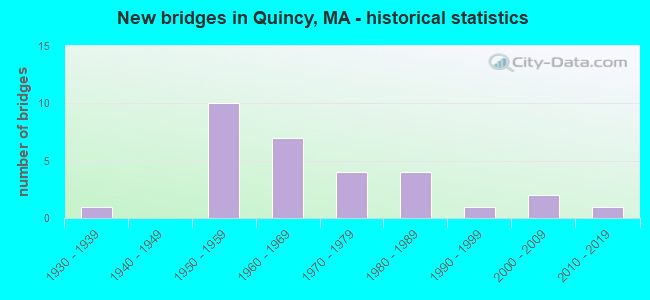
- New bridges - historical statistics
- 11930-1939
- 101950-1959
- 71960-1969
- 41970-1979
- 41980-1989
- 11990-1999
- 22000-2009
- 12010-2019

- Reconstructed bridges - Historical Statistics
- 51970-1979
- 31980-1989
- 01990-1999
- 12000-2009
- 02010-2019
- 12020-2022


- Bridge Condition - Deck
- 3.6%Very good
- 39.3%Good
- 46.4%Satisfactory
- 7.1%Fair
- 3.6%Poor

- Bridge Condition - Superstructure
- 3.6%Very good
- 39.3%Good
- 32.1%Satisfactory
- 25.0%Fair

- Bridge Condition - Substructure
- 32.1%Good
- 57.1%Satisfactory
- 7.1%Fair
- 3.6%Poor

- Bridge Condition - Channel
- 33.3%Very good
- 33.3%Good
- 33.3%Satisfactory

- Bridge Condition - Culverts
- 50.0%Good
- 50.0%Satisfactory
Find on map >> Show street view
Structure Number: Q010015WJDOTNBI, Location: AT WEYMOUTH TWN LINE (Lat: 42.244592, Lng: -70.967200), Route carried "on" structure: Alternate State highway 3A, Year Built: 2018, Status: Open, Structure Length: 42.88m (140.68ft), Average Daily Traffic: 39,120 (year 2018), Truck Traffic: 5%, Design Load: HL 93, Features Intersected: WATER FORE RIVER, Facility Carried by Structure: ST 3 A
Minimum Vertical Clearance: 5.33m (17.49ft), Kilometerpoint: 0.000, Lanes on structure: 4, Lanes under structure: 2, Owner: State Highway Agency, Approaching Roadway Width: 17.7m (58.1ft), Navigation Control: Yes ( Vertical Clearance: 53.5m (175.5ft), Horizontal Clearance: 76.2m (250.0ft)), Material/Design: Steel, Design/Construction: Movable - Lift, Number Of Spans In Main Unit: 1, Number Of Approach Spans: 8, Length of Maximum Span: 98.8m (324.1ft), Curb or Sidewalk Widths: Left: 2.0m (6.6ft), Right: 2.0m (6.6ft), Curb-To-Curb Width: 17.7m (58.1ft), Out-to-Out Width: 22.5m (73.8ft)
Condition: Deck: Good, Superstructure: Satisfactory, Substructure: Good, Channel: Very good, Operating Rating: 42.1 metric tons, Method Used To Determine Operating Rating: Load and Resistance Factor Rating (LRFR) rating reported by rating factor(RF) method using HL-93 loadings, Inventory Rating: 32.4 metric tons, Method Used To Determine Inventory Rating: Load and Resistance Factor Rating (LRFR) rating reported by rating factor(RF) method using HL-93 loadings, Structural Evaluation: Equal to present minimum criteria, Deck Geometry: Somewhat better than minimum adequacy, Underclear: Somewhat better than minimum adequacy, Waterway Adequacy: Superior to present desirable criteria, Approach Roadway Alignment: Equal to present desirable criteria, Designated Inspection Frequency: Every 24 months, Critical Feature Inspection Frequency: Every 24 months, Inspection Date: October 2020, Critical Feature Inspection Date: October 2020, Deck Structure Type: Concrete Cast-file-Place, Wearing Surface/Protective System: Wearing Surface: Monolithic Concrete, Deck Protection: Epoxy Coated Reinforcing
Find on map >> Show street view
Structure Number: Q010024DADOTNBI, Location: .6 MI N OF RTE 3A (Lat: 42.266486, Lng: -70.996917), Route carried "on" structure: City street , Year Built: 1974, Status: Posted for load-capacity, Structure Length: 1.22m (4.00ft), Average Daily Traffic: 40,200 (year 2019), Truck Traffic: 3%, Average Future Daily Traffic: 64,751 (year 2032), Design Load: H 20, Features Intersected: WATER BLACK CREEK, Facility Carried by Structure: HWY QNCY SHOR DR
Minimum Vertical Clearance: 30+ m (98+ ft), Kilometerpoint: 0.080, Lanes on structure: 4, Owner: State Highway Agency, Approaching Roadway Width: 16.5m (54.1ft), Skew: 21 degrees, Material/Design: Concrete, Design/Construction: Culvert, Number Of Spans In Main Unit: 3, Length of Maximum Span: 3.7m (12.1ft), Curb or Sidewalk Widths: Left: 3.0m (9.8ft), Right: 3.7m (12.1ft), Curb-To-Curb Width: 16.5m (54.1ft), Out-to-Out Width: 24.7m (81.0ft)
Condition: Channel: Satisfactory, Culverts: Satisfactory, Operating Rating: 98.0 metric tons, Method Used To Determine Operating Rating: Load Factor (LF), Inventory Rating: 58.8 metric tons, Method Used To Determine Inventory Rating: Load Factor (LF), Structural Evaluation: Equal to present minimum criteria, Deck Geometry: Meets minimum limits, Waterway Adequacy: Equal to present minimum criteria, Approach Roadway Alignment: Better than present minimum criteria, Length Of Structure Improvement: 0.60m (1.97ft), Designated Inspection Frequency: Every 24 months, Underwater Inspection Frequency: Every 36 months, Inspection Date: October 2021, Underwater Inspection Date: May 2020, Bridge Improvement Cost: $680,000, Roadway Improvement Cost: $69,000, Total Project Cost: $1,021,000 ( Estimate for 2022), Wearing Surface/Protective System: Wearing Surface: Bituminous
Find on map >> Show street view
Structure Number: Q010034UBMBTNBI, Location: 1.0 MIE. JCT. GRANITE AVE (Lat: 42.274883, Lng: -71.029161), Route carried "on" structure: City street , Year Built: 1969, Status: Open, Structure Length: 4.37m (14.34ft), Average Daily Traffic: 11,700 (year 2013), Truck Traffic: 10%, Average Future Daily Traffic: 12,950 (year 2031), Design Load: H 20, Features Intersected: TR RED LINE SSH, Facility Carried by Structure: HWY W SQUANTM ST
Minimum Vertical Clearance: 30+ m (98+ ft), Kilometerpoint: 1.287, Lanes on structure: 4, Owner: State Agenciy, Maintenance Responsibility: State Highway Agency, Approaching Roadway Width: 13.4m (44.0ft), Material/Design: Steel, Design/Construction: Stringer/Multi-beam, Number Of Spans In Main Unit: 2, Length of Maximum Span: 22.4m (73.5ft), Curb or Sidewalk Widths: Left: 2.4m (7.9ft), Right: 2.4m (7.9ft), Curb-To-Curb Width: 13.4m (44.0ft), Out-to-Out Width: 19.1m (62.7ft)
Condition: Deck: Satisfactory, Superstructure: Fair, Substructure: Fair, Operating Rating: 53.0 metric tons, Method Used To Determine Operating Rating: Load Factor (LF), Inventory Rating: 31.8 metric tons, Method Used To Determine Inventory Rating: Load Factor (LF), Structural Evaluation: Somewhat better than minimum adequacy, Deck Geometry: High priority of replacement, Underclear: High priority of corrective action, Approach Roadway Alignment: Better than present minimum criteria, Length Of Structure Improvement: 4.40m (14.44ft), Designated Inspection Frequency: Every 24 months, Inspection Date: October 2020, Bridge Improvement Cost: $3,302,000, Roadway Improvement Cost: $331,000, Total Project Cost: $4,954,000 ( Estimate for 2022), Deck Structure Type: Concrete Cast-file-Place, Wearing Surface/Protective System: Wearing Surface: Bituminous
Find on map >> Show street view
Structure Number: Q01003B2RMBTNBI, Location: AT N. QUINCY T STATION (Lat: 42.274547, Lng: -71.029647), Route carried "on" structure: City street , Year Built: 1969, Status: Open, Structure Length: 2.77m (9.09ft), Average Daily Traffic: 32,300 (year 2019), Truck Traffic: 5%, Average Future Daily Traffic: 51,327 (year 2032), Design Load: HS 20, Features Intersected: HWY NEWPORT AVE, Facility Carried by Structure: HWY W SQUANTM ST
Minimum Vertical Clearance: 30+ m (98+ ft), Kilometerpoint: 1.287, Lanes on structure: 4, Lanes under structure: 4, Owner: State Agenciy, Maintenance Responsibility: State Highway Agency, Approaching Roadway Width: 13.4m (44.0ft), Material/Design: Steel, Design/Construction: Stringer/Multi-beam, Number Of Spans In Main Unit: 2, Length of Maximum Span: 19.0m (62.3ft), Curb or Sidewalk Widths: Left: 2.4m (7.9ft), Right: 2.4m (7.9ft), Curb-To-Curb Width: 13.4m (44.0ft), Out-to-Out Width: 19.1m (62.7ft)
Condition: Deck: Satisfactory, Superstructure: Fair, Substructure: Satisfactory, Operating Rating: 51.4 metric tons, Method Used To Determine Operating Rating: Load Factor (LF), Inventory Rating: 30.8 metric tons, Method Used To Determine Inventory Rating: Load Factor (LF), Structural Evaluation: Somewhat better than minimum adequacy, Deck Geometry: High priority of replacement, Underclear: High priority of corrective action, Approach Roadway Alignment: Better than present minimum criteria, Length Of Structure Improvement: 2.80m (9.19ft), Designated Inspection Frequency: Every 24 months, Inspection Date: June 2021, Bridge Improvement Cost: $2,101,000, Roadway Improvement Cost: $211,000, Total Project Cost: $3,152,000 ( Estimate for 2022), Deck Structure Type: Concrete Cast-file-Place, Wearing Surface/Protective System: Wearing Surface: Bituminous, Membrane: Built-up
Find on map >> Show street view
Structure Number: Q01003B32DOTNBI, Location: N. QUINCY T STATION (Lat: 42.274681, Lng: -71.029467), Route carried "on" structure: Ramp City street , Year Built: 1969, Status: Open, Structure Length: 8.99m (29.49ft), Average Daily Traffic: 7,758 (year 2019), Truck Traffic: 6%, Average Future Daily Traffic: 11,371 (year 2032), Design Load: HS 20, Features Intersected: OTHER PARKING, Facility Carried by Structure: HWY W SQUA ON RP
Minimum Vertical Clearance: 30+ m (98+ ft), Kilometerpoint: 1.287, Lanes on structure: 2, Owner: State Highway Agency, Approaching Roadway Width: 6.7m (22.0ft), Material/Design: Prestressed concrete, Design/Construction: Box Beam or Girders - Single/Spread, Number Of Spans In Main Unit: 4, Length of Maximum Span: 21.9m (71.9ft), Curb or Sidewalk Widths: Left: 0.5m (1.6ft), Right: 1.8m (5.9ft), Curb-To-Curb Width: 6.7m (22.0ft), Out-to-Out Width: 9.8m (32.2ft)
Condition: Deck: Satisfactory, Superstructure: Satisfactory, Substructure: Satisfactory, Operating Rating: 61.5 metric tons, Method Used To Determine Operating Rating: Load Factor (LF), Inventory Rating: 36.8 metric tons, Method Used To Determine Inventory Rating: Load Factor (LF), Structural Evaluation: Equal to present minimum criteria, Deck Geometry: High priority of replacement, Approach Roadway Alignment: Better than present minimum criteria, Length Of Structure Improvement: 9.00m (29.53ft), Designated Inspection Frequency: Every 24 months, Inspection Date: May 2021, Bridge Improvement Cost: $3,734,000, Roadway Improvement Cost: $374,000, Total Project Cost: $5,602,000 ( Estimate for 2022), Deck Structure Type: Concrete Cast-file-Place, Wearing Surface/Protective System: Wearing Surface: Bituminous, Membrane: Built-up
Find on map >> Show street view
Structure Number: Q01003B33DOTNBI, Location: AT N. QUINCY T STATION (Lat: 42.274864, Lng: -71.029778), Route carried "on" structure: Ramp City street , Year Built: 1969, Status: Open, Structure Length: 6.08m (19.95ft), Average Daily Traffic: 5,689 (year 2019), Truck Traffic: 4%, Average Future Daily Traffic: 7,896 (year 2032), Design Load: HS 20, Features Intersected: OTHER RELIEF, Facility Carried by Structure: HWY W SQU OFF RP
Minimum Vertical Clearance: 30+ m (98+ ft), Kilometerpoint: 1.287, Lanes on structure: 2, Owner: State Highway Agency, Approaching Roadway Width: 6.7m (22.0ft), Material/Design: Prestressed concrete, Design/Construction: Box Beam or Girders - Single/Spread, Number Of Spans In Main Unit: 3, Length of Maximum Span: 20.3m (66.6ft), Curb or Sidewalk Widths: Left: 0.5m (1.6ft), Right: 1.8m (5.9ft), Curb-To-Curb Width: 6.7m (22.0ft), Out-to-Out Width: 9.8m (32.2ft)
Condition: Deck: Satisfactory, Superstructure: Satisfactory, Substructure: Good, Operating Rating: 51.4 metric tons, Method Used To Determine Operating Rating: Load Factor (LF), Inventory Rating: 30.8 metric tons, Method Used To Determine Inventory Rating: Load Factor (LF), Structural Evaluation: Equal to present minimum criteria, Deck Geometry: High priority of replacement, Approach Roadway Alignment: Better than present minimum criteria, Length Of Structure Improvement: 6.10m (20.01ft), Designated Inspection Frequency: Every 24 months, Inspection Date: May 2021, Bridge Improvement Cost: $2,349,000, Roadway Improvement Cost: $235,000, Total Project Cost: $3,524,000 ( Estimate for 2022), Deck Structure Type: Concrete Cast-file-Place, Wearing Surface/Protective System: Wearing Surface: Bituminous, Membrane: Built-up
Find on map >> Show street view
Structure Number: Q010044UCMBTNBI, Location: 0.04 MI NE OF NEWPORT AVE (Lat: 42.265692, Lng: -71.019392), Route carried "on" structure: City street , Year Built: 1968, Status: Open, Structure Length: 1.83m (6.00ft), Average Daily Traffic: 25,600 (year 2012), Truck Traffic: 3%, Average Future Daily Traffic: 12,950 (year 2031), Design Load: H 20, Features Intersected: TR RED LINE SSH, Facility Carried by Structure: HWY BEALE ST
Minimum Vertical Clearance: 30+ m (98+ ft), Kilometerpoint: 0.338, Lanes on structure: 4, Owner: State Agenciy, Maintenance Responsibility: State Highway Agency, Approaching Roadway Width: 17.1m (56.1ft), Material/Design: Steel, Design/Construction: Stringer/Multi-beam, Number Of Spans In Main Unit: 1, Length of Maximum Span: 18.3m (60.0ft), Curb or Sidewalk Widths: Left: 2.4m (7.9ft), Right: 1.8m (5.9ft), Curb-To-Curb Width: 17.1m (56.1ft), Out-to-Out Width: 22.0m (72.2ft)
Condition: Deck: Satisfactory, Superstructure: Good, Substructure: Satisfactory, Operating Rating: 46.4 metric tons, Method Used To Determine Operating Rating: Allowable Stress (AS), Inventory Rating: 24.1 metric tons, Method Used To Determine Inventory Rating: Allowable Stress (AS), Structural Evaluation: Somewhat better than minimum adequacy, Deck Geometry: Somewhat better than minimum adequacy, Underclear: High priority of corrective action, Approach Roadway Alignment: Equal to present minimum criteria, Length Of Structure Improvement: 1.90m (6.23ft), Designated Inspection Frequency: Every 24 months, Inspection Date: March 2021, Bridge Improvement Cost: $1,642,000, Roadway Improvement Cost: $165,000, Total Project Cost: $2,464,000 ( Estimate for 2022), Deck Structure Type: Concrete Cast-file-Place, Wearing Surface/Protective System: Wearing Surface: Bituminous
Find on map >> Show street view
Structure Number: Q010054UEMBTNBI, Location: 1.8 MI E OF JCT. I93 (Lat: 42.256083, Lng: -71.009333), Route carried "on" structure: City street , Year Built: 1967, Status: Open, Structure Length: 2.13m (6.99ft), Average Daily Traffic: 15,800 (year 2013), Truck Traffic: 10%, Average Future Daily Traffic: 22,268 (year 2031), Design Load: H 20, Features Intersected: TR RED LINE SSH, Facility Carried by Structure: HWY ADAMS ST
Minimum Vertical Clearance: 30+ m (98+ ft), Kilometerpoint: 0.000, Lanes on structure: 4, Base Highway Network: Yes, Owner: State Agenciy, Maintenance Responsibility: State Highway Agency, Approaching Roadway Width: 16.9m (55.4ft), Skew: 24 degrees, Material/Design: Steel, Design/Construction: Stringer/Multi-beam, Number Of Spans In Main Unit: 1, Length of Maximum Span: 19.5m (64.0ft), Curb or Sidewalk Widths: Left: 1.8m (5.9ft), Right: 1.8m (5.9ft), Curb-To-Curb Width: 16.9m (55.4ft), Out-to-Out Width: 21.2m (69.6ft)
Condition: Deck: Fair, Superstructure: Satisfactory, Substructure: Satisfactory, Operating Rating: 45.9 metric tons, Method Used To Determine Operating Rating: Allowable Stress (AS), Inventory Rating: 24.3 metric tons, Method Used To Determine Inventory Rating: Allowable Stress (AS), Structural Evaluation: Equal to present minimum criteria, Deck Geometry: Somewhat better than minimum adequacy, Underclear: High priority of corrective action, Approach Roadway Alignment: Better than present minimum criteria, Length Of Structure Improvement: 2.20m (7.22ft), Designated Inspection Frequency: Every 24 months, Inspection Date: August 2020, Bridge Improvement Cost: $1,833,000, Roadway Improvement Cost: $184,000, Total Project Cost: $2,750,000 ( Estimate for 2022), Deck Structure Type: Concrete Cast-file-Place, Wearing Surface/Protective System: Wearing Surface: Bituminous
Find on map >> Show street view
Structure Number: Q010064UFMBTNBI, Location: 0.25 MI SW OF QUINCY AVE (Lat: 42.253264, Lng: -71.006381), Route carried "on" structure: City street , Year Built: 1971, Status: Open, Structure Length: 2.23m (7.32ft), Average Daily Traffic: 3,000 (year 1997), Truck Traffic: 3%, Average Future Daily Traffic: 4,738 (year 2031), Design Load: H 20, Features Intersected: TR RED LINE SSH, Facility Carried by Structure: HWY DIMMOCK ST
Minimum Vertical Clearance: 30+ m (98+ ft), Kilometerpoint: 0.467, Lanes on structure: 2, Owner: State Agenciy, Maintenance Responsibility: State Highway Agency, Approaching Roadway Width: 13.4m (44.0ft), Material/Design: Steel, Design/Construction: Stringer/Multi-beam, Number Of Spans In Main Unit: 1, Length of Maximum Span: 20.7m (67.9ft), Curb or Sidewalk Widths: Left: 1.8m (5.9ft), Right: 1.8m (5.9ft), Curb-To-Curb Width: 13.5m (44.3ft), Out-to-Out Width: 17.8m (58.4ft)
Condition: Deck: Good, Superstructure: Good, Substructure: Satisfactory, Operating Rating: 40.5 metric tons, Method Used To Determine Operating Rating: Allowable Stress (AS), Inventory Rating: 32.4 metric tons, Method Used To Determine Inventory Rating: Allowable Stress (AS), Structural Evaluation: Equal to present minimum criteria, Deck Geometry: Superior to present desirable criteria, Underclear: High priority of corrective action, Approach Roadway Alignment: Better than present minimum criteria, Length Of Structure Improvement: 2.30m (7.55ft), Designated Inspection Frequency: Every 24 months, Inspection Date: October 2020, Bridge Improvement Cost: $322,000, Roadway Improvement Cost: $33,000, Total Project Cost: $484,000 ( Estimate for 2022), Deck Structure Type: Concrete Cast-file-Place, Wearing Surface/Protective System: Wearing Surface: Bituminous
Find on map >> Show street view
Structure Number: Q010074UGMBTNBI, Location: 0.25 MI SE OF QUINCY AVE (Lat: 42.248867, Lng: -71.003761), Route carried "on" structure: City street , Year Built: 1971, Status: Open, Structure Length: 2.47m (8.10ft), Average Daily Traffic: 8,200 (year 1997), Truck Traffic: 10%, Average Future Daily Traffic: 12,950 (year 2031), Design Load: H 20, Features Intersected: TR RED LINE SSH, Facility Carried by Structure: HWY GRANITE ST
Minimum Vertical Clearance: 30+ m (98+ ft), Kilometerpoint: 1.658, Lanes on structure: 4, Owner: State Agenciy, Maintenance Responsibility: State Highway Agency, Approaching Roadway Width: 21.9m (71.9ft), Skew: 34 degrees, Material/Design: Steel, Design/Construction: Stringer/Multi-beam, Number Of Spans In Main Unit: 1, Length of Maximum Span: 21.0m (68.9ft), Curb or Sidewalk Widths: Left: 3.0m (9.8ft), Right: 3.0m (9.8ft), Curb-To-Curb Width: 21.9m (71.9ft), Out-to-Out Width: 29.9m (98.1ft)
Condition: Deck: Good, Superstructure: Good, Substructure: Good, Operating Rating: 46.4 metric tons, Method Used To Determine Operating Rating: Allowable Stress (AS), Inventory Rating: 22.9 metric tons, Method Used To Determine Inventory Rating: Allowable Stress (AS), Structural Evaluation: Somewhat better than minimum adequacy, Deck Geometry: Superior to present desirable criteria, Underclear: High priority of corrective action, Approach Roadway Alignment: Better than present minimum criteria, Length Of Structure Improvement: 2.50m (8.20ft), Designated Inspection Frequency: Every 24 months, Inspection Date: October 2020, Bridge Improvement Cost: $2,937,000, Roadway Improvement Cost: $294,000, Total Project Cost: $4,406,000 ( Estimate for 2022), Deck Structure Type: Concrete Cast-file-Place, Wearing Surface/Protective System: Wearing Surface: Bituminous
Find on map >> Show street view
Structure Number: Q010084UDMBTNBI, Location: NEAR GRANITE STREET (Lat: 42.243744, Lng: -71.004303), Route carried "on" structure: City street , Year Built: 1972, Status: Open, Structure Length: 3.54m (11.61ft), Average Daily Traffic: 12,114 (year 1997), Truck Traffic: 7%, Average Future Daily Traffic: 19,132 (year 2030), Design Load: H 20, Features Intersected: TR RED LINE SSH, Facility Carried by Structure: HWY SCHOOL ST
Minimum Vertical Clearance: 30+ m (98+ ft), Kilometerpoint: 0.000, Lanes on structure: 4, Owner: State Agenciy, Maintenance Responsibility: State Highway Agency, Approaching Roadway Width: 13.4m (44.0ft), Skew: 1 degrees, Material/Design: Steel, Design/Construction: Stringer/Multi-beam, Number Of Spans In Main Unit: 1, Number Of Approach Spans: 1, Length of Maximum Span: 16.2m (53.1ft), Curb or Sidewalk Widths: Left: 1.8m (5.9ft), Right: 1.8m (5.9ft), Curb-To-Curb Width: 13.4m (44.0ft), Out-to-Out Width: 17.7m (58.1ft)
Condition: Deck: Satisfactory, Superstructure: Good, Substructure: Good, Operating Rating: 44.5 metric tons, Method Used To Determine Operating Rating: Allowable Stress (AS), Inventory Rating: 32.7 metric tons, Method Used To Determine Inventory Rating: Allowable Stress (AS), Structural Evaluation: Better than present minimum criteria, Deck Geometry: High priority of replacement, Underclear: High priority of corrective action, Approach Roadway Alignment: Superior to present desirable criteria, Length Of Structure Improvement: 3.60m (11.81ft), Designated Inspection Frequency: Every 24 months, Inspection Date: August 2020, Bridge Improvement Cost: $2,343,000, Roadway Improvement Cost: $235,000, Total Project Cost: $3,515,000 ( Estimate for 2022), Deck Structure Type: Concrete Cast-file-Place, Wearing Surface/Protective System: Wearing Surface: Bituminous
Find on map >> Show street view
Structure Number: Q01009399DOTNBI, Location: 1.3KM SE OF JET I93&NEPON (Lat: 42.279172, Lng: -71.032500), Route carried "on" structure: Alternate State highway 3A, Year Built: 1969, Year Reconstructed: 2012, Status: Open, Structure Length: 7.40m (24.28ft), Average Daily Traffic: 24,181 (year 2018), Truck Traffic: 4%, Average Future Daily Traffic: 41,062 (year 2031), Design Load: H 20, Features Intersected: COMB SGMRE ST&MBTA&REDS, Facility Carried by Structure: HWY HANCOCK ST
Minimum Vertical Clearance: 30+ m (98+ ft), Kilometerpoint: 0.000, Lanes on structure: 4, Lanes under structure: 2, Base Highway Network: Yes, Owner: State Highway Agency, Approaching Roadway Width: 14.6m (47.9ft), Skew: 6 degrees, Material/Design: Prestressed concrete, Design/Construction: Slab, Number Of Spans In Main Unit: 4, Length of Maximum Span: 24.7m (81.0ft), Curb or Sidewalk Widths: Left: 2.0m (6.6ft), Right: 2.1m (6.9ft), Curb-To-Curb Width: 14.6m (47.9ft), Out-to-Out Width: 19.5m (64.0ft)
Condition: Deck: Satisfactory, Superstructure: Satisfactory, Substructure: Satisfactory, Operating Rating: 39.7 metric tons, Method Used To Determine Operating Rating: Load Factor (LF), Inventory Rating: 21.8 metric tons, Method Used To Determine Inventory Rating: Load Factor (LF), Structural Evaluation: Somewhat better than minimum adequacy, Deck Geometry: High priority of replacement, Underclear: High priority of corrective action, Approach Roadway Alignment: Better than present minimum criteria, Length Of Structure Improvement: 7.50m (24.61ft), Designated Inspection Frequency: Every 24 months, Inspection Date: October 2020, Bridge Improvement Cost: $5,745,000, Roadway Improvement Cost: $575,000, Total Project Cost: $8,618,000 ( Estimate for 2022), Deck Structure Type: Concrete Precast Panels, Wearing Surface/Protective System: Wearing Surface: Bituminous, Membrane: Built-up
Find on map >> Show street view
Structure Number: Q010163F5DOTNBI, Location: .8 KM NW OF JCT SR 53 (Lat: 42.252314, Lng: -70.989797), Route carried "on" structure: Alternate State highway 3A, Year Built: 1994, Status: Open, Structure Length: 1.63m (5.35ft), Average Daily Traffic: 30,500 (year 2018), Truck Traffic: 2%, Average Future Daily Traffic: 71,068 (year 2031), Features Intersected: WATER TOWN RIV BAY CANAL, Facility Carried by Structure: ST 3 A/S ARTERY
Minimum Vertical Clearance: 30+ m (98+ ft), Kilometerpoint: 0.000, Lanes on structure: 4, Base Highway Network: Yes, Owner: State Highway Agency, Approaching Roadway Width: 20.1m (65.9ft), Skew: 21 degrees, Material/Design: Concrete, Design/Construction: Culvert, Number Of Spans In Main Unit: 3, Length of Maximum Span: 4.9m (16.1ft), Curb or Sidewalk Widths: Left: 2.1m (6.9ft), Right: 2.0m (6.6ft), Curb-To-Curb Width: 20.0m (65.6ft), Out-to-Out Width: 89.9m (294.9ft)
Condition: Channel: Good, Culverts: Good, Inventory Rating: 68.0 metric tons, Method Used To Determine Inventory Rating: Load Factor (LF), Structural Evaluation: Better than present minimum criteria, Deck Geometry: Better than present minimum criteria, Waterway Adequacy: Equal to present desirable criteria, Approach Roadway Alignment: Equal to present desirable criteria, Length Of Structure Improvement: 0.30m (0.98ft), Designated Inspection Frequency: Every 24 months, Inspection Date: August 2020, Bridge Improvement Cost: $441,000, Roadway Improvement Cost: $45,000, Total Project Cost: $662,000 ( Estimate for 2022)
Find on map >> Show street view
Structure Number: Q010204UHMBTNBI, Location: 1.5 MI NE. JCT. SR3 & I93 (Lat: 42.241197, Lng: -71.005089), Route carried "on" structure: City street , Year Built: 1936, Year Reconstructed: 1985, Status: Open, Structure Length: 6.04m (19.82ft), Average Daily Traffic: 28,100 (year 2013), Truck Traffic: 10%, Average Future Daily Traffic: 12,950 (year 2031), Design Load: HS 20, Features Intersected: COMB BRGN PKY&MBTA&REDS, Facility Carried by Structure: HWY WATER ST
Minimum Vertical Clearance: 30+ m (98+ ft), Kilometerpoint: 0.000, Lanes on structure: 4, Lanes under structure: 4, Owner: State Agenciy, Maintenance Responsibility: State Highway Agency, Approaching Roadway Width: 14.6m (47.9ft), Skew: 4 degrees, Material/Design: Steel, Design/Construction: Stringer/Multi-beam, Number Of Spans In Main Unit: 2, Length of Maximum Span: 32.3m (106.0ft), Curb or Sidewalk Widths: Left: 1.8m (5.9ft), Right: 1.8m (5.9ft), Curb-To-Curb Width: 14.6m (47.9ft), Out-to-Out Width: 19.1m (62.7ft)
Condition: Deck: Good, Superstructure: Good, Substructure: Satisfactory, Operating Rating: 63.0 metric tons, Method Used To Determine Operating Rating: Load Factor (LF), Inventory Rating: 37.7 metric tons, Method Used To Determine Inventory Rating: Load Factor (LF), Structural Evaluation: Equal to present minimum criteria, Deck Geometry: High priority of replacement, Underclear: High priority of corrective action, Approach Roadway Alignment: Better than present minimum criteria, Length Of Structure Improvement: 6.10m (20.01ft), Designated Inspection Frequency: Every 24 months, Inspection Date: September 2020, Bridge Improvement Cost: $3,279,000, Roadway Improvement Cost: $328,000, Total Project Cost: $4,919,000 ( Estimate for 2022), Deck Structure Type: Concrete Cast-file-Place, Wearing Surface/Protective System: Wearing Surface: Bituminous
Find on map >> Show street view
Structure Number: Q010383FGDOTNBI, Location: 3.2 KM N OF JCT I93&128 (Lat: 42.251847, Lng: -71.038167), Route carried "on" structure: City street , Year Built: 1954, Status: Open, Structure Length: 4.33m (14.21ft), Average Daily Traffic: 2,200 (year 2018), Truck Traffic: 6%, Average Future Daily Traffic: 6,949 (year 2031), Design Load: H 20, Features Intersected: I 93 /US1/ST3, Facility Carried by Structure: HWY STEDMAN ST
Minimum Vertical Clearance: 30+ m (98+ ft), Kilometerpoint: 0.000, Lanes on structure: 2, Lanes under structure: 6, Owner: State Highway Agency, Approaching Roadway Width: 9.1m (29.9ft), Skew: 2 degrees, Material/Design: Steel continuous, Design/Construction: Stringer/Multi-beam, Number Of Spans In Main Unit: 2, Length of Maximum Span: 21.0m (68.9ft), Curb or Sidewalk Widths: Left: 1.5m (4.9ft), Right: 1.5m (4.9ft), Curb-To-Curb Width: 9.1m (29.9ft), Out-to-Out Width: 12.9m (42.3ft)
Condition: Deck: Poor, Superstructure: Fair, Substructure: Satisfactory, Operating Rating: 39.4 metric tons, Method Used To Determine Operating Rating: Allowable Stress (AS), Inventory Rating: 23.2 metric tons, Method Used To Determine Inventory Rating: Allowable Stress (AS), Structural Evaluation: Somewhat better than minimum adequacy, Deck Geometry: Meets minimum limits, Underclear: High priority of corrective action, Approach Roadway Alignment: Equal to present desirable criteria, Length Of Structure Improvement: 4.40m (14.44ft), Designated Inspection Frequency: Every 12 months, Other Special Inspection Frequency: Every 12 months, Inspection Date: August 2020, Other Special Inspection Date: August 2021, Bridge Improvement Cost: $2,230,000, Roadway Improvement Cost: $224,000, Total Project Cost: $3,346,000 ( Estimate for 2022), Deck Structure Type: Concrete Cast-file-Place, Wearing Surface/Protective System: Wearing Surface: Monolithic Concrete
Find on map >> Show street view
Structure Number: Q010393FFDOTNBI, Location: 3.2 KM N OF JCT I93&128 (Lat: 42.250544, Lng: -71.037831), Route carried "on" structure: City street , Year Built: 1958, Year Reconstructed: 2020, Status: Open, Structure Length: 4.36m (14.30ft), Average Daily Traffic: 20,000 (year 2018), Truck Traffic: 5%, Average Future Daily Traffic: 18,636 (year 2031), Design Load: HL 93, Features Intersected: I 93 /US1/ST3, Facility Carried by Structure: HWY ROBERTSON ST
Minimum Vertical Clearance: 30+ m (98+ ft), Kilometerpoint: 0.000, Lanes on structure: 2, Lanes under structure: 8, Owner: State Highway Agency, Approaching Roadway Width: 10.6m (34.8ft), Skew: 2 degrees, Material/Design: Steel continuous, Design/Construction: Stringer/Multi-beam, Number Of Spans In Main Unit: 2, Length of Maximum Span: 20.4m (66.9ft), Curb or Sidewalk Widths: Left: 1.6m (5.2ft), Right: 1.6m (5.2ft), Curb-To-Curb Width: 10.7m (35.1ft), Out-to-Out Width: 14.6m (47.9ft)
Condition: Deck: Very good, Superstructure: Very good, Substructure: Good, Operating Rating: 51.8 metric tons, Method Used To Determine Operating Rating: Load and Resistance Factor Rating (LRFR) rating reported by rating factor(RF) method using HL-93 loadings, Inventory Rating: 42.1 metric tons, Method Used To Determine Inventory Rating: Load and Resistance Factor Rating (LRFR) rating reported by rating factor(RF) method using HL-93 loadings, Structural Evaluation: Better than present minimum criteria, Deck Geometry: Somewhat better than minimum adequacy, Underclear: High priority of corrective action, Approach Roadway Alignment: Meets minimum limits, Designated Inspection Frequency: Every 24 months, Inspection Date: August 2020, Deck Structure Type: Concrete Cast-file-Place, Wearing Surface/Protective System: Wearing Surface: Latex Concrete, Membrane: Built-up, Deck Protection: Epoxy Coated Reinforcing
Find on map >> Show street view
Structure Number: Q010403FEDOTNBI, Location: 2.9 KM N OF JCT I93&128 (Lat: 42.247406, Lng: -71.036556), Route carried "on" structure: City street , Year Built: 1954, Year Reconstructed: 1988, Status: Open, Structure Length: 4.75m (15.58ft), Average Daily Traffic: 3,500 (year 2018), Truck Traffic: 7%, Average Future Daily Traffic: 7,739 (year 2031), Design Load: H 20, Features Intersected: I 93 /US1/ST3, Facility Carried by Structure: HWY BATES AVE
Minimum Vertical Clearance: 30+ m (98+ ft), Kilometerpoint: 0.000, Lanes on structure: 2, Lanes under structure: 8, Owner: State Highway Agency, Approaching Roadway Width: 9.1m (29.9ft), Skew: 3 degrees, Material/Design: Steel, Design/Construction: Stringer/Multi-beam, Number Of Spans In Main Unit: 2, Length of Maximum Span: 23.2m (76.1ft), Curb or Sidewalk Widths: Left: 1.5m (4.9ft), Right: 1.5m (4.9ft), Curb-To-Curb Width: 9.1m (29.9ft), Out-to-Out Width: 12.9m (42.3ft)
Condition: Deck: Satisfactory, Superstructure: Good, Substructure: Good, Operating Rating: 67.3 metric tons, Method Used To Determine Operating Rating: Load Factor (LF), Inventory Rating: 40.3 metric tons, Method Used To Determine Inventory Rating: Load Factor (LF), Structural Evaluation: Better than present minimum criteria, Deck Geometry: Meets minimum limits, Underclear: Meets minimum limits, Approach Roadway Alignment: Equal to present minimum criteria, Length Of Structure Improvement: 4.80m (15.75ft), Designated Inspection Frequency: Every 24 months, Inspection Date: June 2020, Bridge Improvement Cost: $1,947,000, Roadway Improvement Cost: $195,000, Total Project Cost: $2,921,000 ( Estimate for 2022), Deck Structure Type: Concrete Cast-file-Place, Wearing Surface/Protective System: Wearing Surface: Integral Concrete, Deck Protection: Epoxy Coated Reinforcing
Find on map >> Show street view
Structure Number: Q010413BDDOTNBI, Location: 1.3 MI N OF JCT I93&128 (Lat: 42.244658, Lng: -71.031389), Route carried "on" structure: Interstate 3, Year Built: 1958, Year Reconstructed: 1984, Status: Open, Structure Length: 2.87m (9.42ft), Average Daily Traffic: 166,989 (year 2017), Truck Traffic: 10%, Average Future Daily Traffic: 32,849 (year 2031), Design Load: HS 20+Mod, Features Intersected: HWY WILLARD ST
Minimum Vertical Clearance: 30+ m (98+ ft), Kilometerpoint: 68.862, Lanes on structure: 10, Lanes under structure: 2, Base Highway Network: Yes, Owner: State Highway Agency, Approaching Roadway Width: 33.5m (109.9ft), Skew: 23 degrees, Material/Design: Steel, Design/Construction: Stringer/Multi-beam, Number Of Spans In Main Unit: 1, Length of Maximum Span: 28.0m (91.9ft), Curb-To-Curb Width: 40.8m (133.9ft), Out-to-Out Width: 42.1m (138.1ft)
Condition: Deck: Satisfactory, Superstructure: Satisfactory, Substructure: Satisfactory, Operating Rating: 59.9 metric tons, Method Used To Determine Operating Rating: Load Factor (LF), Inventory Rating: 35.9 metric tons, Method Used To Determine Inventory Rating: Load Factor (LF), Structural Evaluation: Equal to present minimum criteria, Deck Geometry: Equal to present minimum criteria, Underclear: Meets minimum limits, Approach Roadway Alignment: Equal to present minimum criteria, Length Of Structure Improvement: 2.90m (9.51ft), Designated Inspection Frequency: Every 24 months, Inspection Date: June 2020, Bridge Improvement Cost: $957,000, Roadway Improvement Cost: $96,000, Total Project Cost: $1,436,000 ( Estimate for 2022), Deck Structure Type: Concrete Cast-file-Place, Wearing Surface/Protective System: Wearing Surface: Bituminous, Membrane: Preformed Fabric, Deck Protection: Epoxy Coated Reinforcing
Find on map >> Show street view
Structure Number: Q010423BCDOTNBI, Location: 1.2 MI N OF JCT I93&128 (Lat: 42.241119, Lng: -71.025600), Route carried "on" structure: Interstate 3, Year Built: 1959, Year Reconstructed: 1984, Status: Open, Structure Length: 2.26m (7.41ft), Average Daily Traffic: 203,008 (year 2017), Truck Traffic: 11%, Average Future Daily Traffic: 319,334 (year 2031), Design Load: HS 20, Features Intersected: HWY FURNACE BROOK PKWY
Minimum Vertical Clearance: 30+ m (98+ ft), Kilometerpoint: 0.000, Lanes on structure: 10, Lanes under structure: 2, Base Highway Network: Yes, Owner: State Highway Agency, Approaching Roadway Width: 33.5m (109.9ft), Skew: 30 degrees, Material/Design: Steel, Design/Construction: Stringer/Multi-beam, Number Of Spans In Main Unit: 1, Length of Maximum Span: 21.0m (68.9ft), Curb-To-Curb Width: 33.5m (109.9ft), Out-to-Out Width: 36.0m (118.1ft)
Condition: Deck: Satisfactory, Superstructure: Good, Substructure: Satisfactory, Operating Rating: 74.1 metric tons, Method Used To Determine Operating Rating: Load Factor (LF), Inventory Rating: 44.4 metric tons, Method Used To Determine Inventory Rating: Load Factor (LF), Structural Evaluation: Equal to present minimum criteria, Deck Geometry: High priority of replacement, Underclear: Meets minimum limits, Approach Roadway Alignment: Better than present minimum criteria, Length Of Structure Improvement: 2.30m (7.55ft), Designated Inspection Frequency: Every 24 months, Inspection Date: October 2020, Bridge Improvement Cost: $2,343,000, Roadway Improvement Cost: $235,000, Total Project Cost: $3,515,000 ( Estimate for 2022), Deck Structure Type: Concrete Cast-file-Place, Wearing Surface/Protective System: Wearing Surface: Bituminous, Membrane: Built-up, Deck Protection: Epoxy Coated Reinforcing
Find on map >> Show street view
Structure Number: Q010433FDDOTNBI, Location: 1.6 KM N JCT ST 128&I93 (Lat: 42.243242, Lng: -71.027972), Route carried "on" structure: City street , Year Built: 1955, Year Reconstructed: 1989, Status: Open, Structure Length: 3.87m (12.70ft), Average Daily Traffic: 15,800 (year 2018), Truck Traffic: 2%, Average Future Daily Traffic: 23,532 (year 2031), Design Load: H 20, Features Intersected: I 93 /US1/ST3, Facility Carried by Structure: HWY FRN BRK PKWY
Minimum Vertical Clearance: 30+ m (98+ ft), Kilometerpoint: 0.000, Lanes on structure: 2, Lanes under structure: 8, Owner: State Highway Agency, Approaching Roadway Width: 12.2m (40.0ft), Material/Design: Steel, Design/Construction: Stringer/Multi-beam, Number Of Spans In Main Unit: 2, Length of Maximum Span: 18.2m (59.7ft), Curb or Sidewalk Widths: Left: 0.3m (1.0ft), Right: 1.8m (5.9ft), Curb-To-Curb Width: 12.6m (41.3ft), Out-to-Out Width: 15.4m (50.5ft)
Condition: Deck: Good, Superstructure: Satisfactory, Substructure: Satisfactory, Operating Rating: 59.2 metric tons, Method Used To Determine Operating Rating: Load Factor (LF), Inventory Rating: 35.5 metric tons, Method Used To Determine Inventory Rating: Load Factor (LF), Structural Evaluation: Equal to present minimum criteria, Deck Geometry: Better than present minimum criteria, Underclear: High priority of corrective action, Approach Roadway Alignment: Somewhat better than minimum adequacy, Length Of Structure Improvement: 3.90m (12.80ft), Designated Inspection Frequency: Every 24 months, Inspection Date: June 2020, Bridge Improvement Cost: $74,000, Roadway Improvement Cost: $8,000, Total Project Cost: $112,000 ( Estimate for 2022), Deck Structure Type: Concrete Cast-file-Place, Wearing Surface/Protective System: Wearing Surface: Integral Concrete, Deck Protection: Epoxy Coated Reinforcing
Find on map >> Show street view
Structure Number: Q010443BADOTNBI, Location: 1 MI N OF JCT I93&128 (Lat: 42.240264, Lng: -71.024419), Route carried "on" structure: Ramp Interstate 93, Year Built: 1956, Year Reconstructed: 1984, Status: Open, Structure Length: 2.98m (9.78ft), Average Daily Traffic: 9,717 (year 2018), Truck Traffic: 3%, Average Future Daily Traffic: 23,374 (year 2031), Design Load: HS 20+Mod, Features Intersected: HWY WEST ST
Minimum Vertical Clearance: 30+ m (98+ ft), Kilometerpoint: 0.000, Lanes on structure: 1, Lanes under structure: 2, Base Highway Network: Yes, Owner: State Highway Agency, Approaching Roadway Width: 7.0m (23.0ft), Skew: 5 degrees, Material/Design: Steel, Design/Construction: Stringer/Multi-beam, Number Of Spans In Main Unit: 1, Length of Maximum Span: 28.9m (94.8ft), Curb-To-Curb Width: 6.7m (22.0ft), Out-to-Out Width: 7.6m (24.9ft)
Condition: Deck: Good, Superstructure: Satisfactory, Substructure: Satisfactory, Operating Rating: 72.9 metric tons, Method Used To Determine Operating Rating: Load Factor (LF), Inventory Rating: 43.7 metric tons, Method Used To Determine Inventory Rating: Load Factor (LF), Structural Evaluation: Equal to present minimum criteria, Deck Geometry: Equal to present minimum criteria, Underclear: Meets minimum limits, Approach Roadway Alignment: Equal to present desirable criteria, Length Of Structure Improvement: 3.00m (9.84ft), Designated Inspection Frequency: Every 24 months, Inspection Date: September 2021, Bridge Improvement Cost: $340,000, Roadway Improvement Cost: $35,000, Total Project Cost: $511,000 ( Estimate for 2022), Deck Structure Type: Concrete Cast-file-Place, Wearing Surface/Protective System: Wearing Surface: Bituminous, Membrane: Built-up, Deck Protection: Epoxy Coated Reinforcing
Find on map >> Show street view
Structure Number: Q010443BBDOTNBI, Location: 1 MI N OF JCT I93&128 (Lat: 42.239789, Lng: -71.024783), Route carried "on" structure: Ramp Interstate 93, Year Built: 1956, Year Reconstructed: 1984, Status: Open, Structure Length: 3.01m (9.88ft), Average Daily Traffic: 5,858 (year 2019), Truck Traffic: 3%, Average Future Daily Traffic: 21,636 (year 2031), Design Load: HS 20+Mod, Features Intersected: HWY WEST ST
Minimum Vertical Clearance: 30+ m (98+ ft), Kilometerpoint: 0.000, Lanes on structure: 1, Lanes under structure: 2, Base Highway Network: Yes, Owner: State Highway Agency, Approaching Roadway Width: 7.0m (23.0ft), Skew: 5 degrees, Material/Design: Steel, Design/Construction: Stringer/Multi-beam, Number Of Spans In Main Unit: 1, Length of Maximum Span: 29.2m (95.8ft), Curb-To-Curb Width: 6.7m (22.0ft), Out-to-Out Width: 7.2m (23.6ft)
Condition: Deck: Satisfactory, Superstructure: Good, Substructure: Satisfactory, Operating Rating: 74.3 metric tons, Method Used To Determine Operating Rating: Load Factor (LF), Inventory Rating: 44.5 metric tons, Method Used To Determine Inventory Rating: Load Factor (LF), Structural Evaluation: Equal to present minimum criteria, Deck Geometry: Equal to present minimum criteria, Underclear: High priority of corrective action, Approach Roadway Alignment: Better than present minimum criteria, Length Of Structure Improvement: 3.10m (10.17ft), Designated Inspection Frequency: Every 24 months, Inspection Date: September 2021, Bridge Improvement Cost: $351,000, Roadway Improvement Cost: $36,000, Total Project Cost: $527,000 ( Estimate for 2022), Deck Structure Type: Concrete Cast-file-Place, Wearing Surface/Protective System: Wearing Surface: Bituminous, Membrane: Built-up, Deck Protection: Epoxy Coated Reinforcing
Find on map >> Show street view
Structure Number: Q010443BEDOTNBI, Location: 1 MI N OF JCT I93&128 (Lat: 42.239981, Lng: -71.024619), Route carried "on" structure: Interstate 3, Year Built: 1956, Year Reconstructed: 1984, Status: Open, Structure Length: 3.04m (9.97ft), Average Daily Traffic: 205,448 (year 2018), Truck Traffic: 10%, Average Future Daily Traffic: 300,067 (year 2031), Design Load: HS 20, Features Intersected: HWY WEST ST
Minimum Vertical Clearance: 30+ m (98+ ft), Kilometerpoint: 68.106, Lanes on structure: 9, Lanes under structure: 2, Base Highway Network: Yes, Owner: State Highway Agency, Approaching Roadway Width: 16.5m (54.1ft), Skew: 25 degrees, Material/Design: Steel, Design/Construction: Stringer/Multi-beam, Number Of Spans In Main Unit: 1, Length of Maximum Span: 29.5m (96.8ft), Curb-To-Curb Width: 35.9m (117.8ft), Out-to-Out Width: 37.3m (122.4ft)
Condition: Deck: Good, Superstructure: Good, Substructure: Good, Operating Rating: 77.0 metric tons, Method Used To Determine Operating Rating: Load Factor (LF), Inventory Rating: 46.1 metric tons, Method Used To Determine Inventory Rating: Load Factor (LF), Structural Evaluation: Better than present minimum criteria, Deck Geometry: Meets minimum limits, Underclear: Meets minimum limits, Approach Roadway Alignment: Better than present minimum criteria, Length Of Structure Improvement: 3.10m (10.17ft), Designated Inspection Frequency: Every 24 months, Inspection Date: September 2021, Bridge Improvement Cost: $1,374,000, Roadway Improvement Cost: $138,000, Total Project Cost: $2,062,000 ( Estimate for 2022), Deck Structure Type: Concrete Cast-file-Place, Wearing Surface/Protective System: Wearing Surface: Bituminous, Membrane: Preformed Fabric, Deck Protection: Epoxy Coated Reinforcing
Find on map >> Show street view
Structure Number: Q010462J8DOTNBI, Location: I 93 SB AT ST 28 (Lat: 42.205864, Lng: -71.065458), Route carried "on" structure: Interstate 93, Year Built: 1958, Status: Open, Structure Length: 5.27m (17.29ft), Average Daily Traffic: 38,984 (year 2015), Truck Traffic: 11%, Average Future Daily Traffic: 164,247 (year 2031), Design Load: HS 20, Features Intersected: ST 28 RANDOLPH RD
Minimum Vertical Clearance: 30+ m (98+ ft), Kilometerpoint: 0.000, Lanes on structure: 5, Lanes under structure: 4, Base Highway Network: Yes, Owner: State Highway Agency, Approaching Roadway Width: 19.8m (65.0ft), Skew: 1 degrees, Material/Design: Steel, Design/Construction: Stringer/Multi-beam, Number Of Spans In Main Unit: 3, Length of Maximum Span: 28.0m (91.9ft), Curb-To-Curb Width: 19.7m (64.6ft), Out-to-Out Width: 22.0m (72.2ft)
Condition: Deck: Satisfactory, Superstructure: Fair, Substructure: Satisfactory, Operating Rating: 65.5 metric tons, Method Used To Determine Operating Rating: Load Factor (LF), Inventory Rating: 37.3 metric tons, Method Used To Determine Inventory Rating: Load Factor (LF), Structural Evaluation: Somewhat better than minimum adequacy, Deck Geometry: High priority of replacement, Underclear: High priority of corrective action, Approach Roadway Alignment: Better than present minimum criteria, Length Of Structure Improvement: 5.30m (17.39ft), Designated Inspection Frequency: Every 24 months, Inspection Date: November 2020, Bridge Improvement Cost: $4,581,000, Roadway Improvement Cost: $459,000, Total Project Cost: $6,872,000 ( Estimate for 2022), Deck Structure Type: Concrete Cast-file-Place, Wearing Surface/Protective System: Wearing Surface: Latex Concrete, Membrane: Built-up, Deck Protection: Epoxy Coated Reinforcing
Find on map >> Show street view
Structure Number: Q010492GTDOTNBI, Location: .32 KM SO OF CENTER ST. (Lat: 42.231239, Lng: -71.011408), Route carried "on" structure: Ramp Other road , Year Built: 1981, Status: Open, Structure Length: 2.26m (7.41ft), Average Daily Traffic: 71,200 (year 2019), Truck Traffic: 11%, Average Future Daily Traffic: 38,693 (year 2032), Design Load: HS 20, Features Intersected: RR CSX SPUR TO LEDGER, Facility Carried by Structure: ST 3 RPS CC&C&X&Y
Minimum Vertical Clearance: 30+ m (98+ ft), Kilometerpoint: 0.000, Lanes on structure: 8, Base Highway Network: Yes, Owner: State Highway Agency, Approaching Roadway Width: 47.5m (155.8ft), Skew: 24 degrees, Material/Design: Steel, Design/Construction: Stringer/Multi-beam, Number Of Spans In Main Unit: 1, Length of Maximum Span: 21.6m (70.9ft), Curb-To-Curb Width: 47.5m (155.8ft), Out-to-Out Width: 59.4m (194.9ft)
Condition: Deck: Good, Superstructure: Satisfactory, Substructure: Good, Operating Rating: 72.9 metric tons, Method Used To Determine Operating Rating: Load Factor (LF), Inventory Rating: 43.7 metric tons, Method Used To Determine Inventory Rating: Load Factor (LF), Structural Evaluation: Equal to present minimum criteria, Deck Geometry: Superior to present desirable criteria, Underclear: Meets minimum limits, Approach Roadway Alignment: Superior to present desirable criteria, Length Of Structure Improvement: 2.30m (7.55ft), Designated Inspection Frequency: Every 24 months, Inspection Date: August 2021, Bridge Improvement Cost: $1,074,000, Roadway Improvement Cost: $108,000, Total Project Cost: $1,612,000 ( Estimate for 2022), Deck Structure Type: Concrete Cast-file-Place, Wearing Surface/Protective System: Wearing Surface: Bituminous, Membrane: Built-up
Find on map >> Show street view
Structure Number: Q010512GUDOTNBI, Location: AT T. STATION (Lat: 42.232222, Lng: -71.010278), Route carried "on" structure: Ramp State highway 3, Year Built: 1981, Status: Open, Structure Length: 15.03m (49.31ft), Average Daily Traffic: 2,100 (year 2019), Truck Traffic: 1%, Average Future Daily Traffic: 11,213 (year 2032), Design Load: HS 20, Features Intersected: OTHER RELIEF
Minimum Vertical Clearance: 30+ m (98+ ft), Kilometerpoint: 0.000, Lanes on structure: 2, Base Highway Network: Yes, Owner: State Highway Agency, Approaching Roadway Width: 8.5m (27.9ft), Skew: 6 degrees, Material/Design: Steel, Design/Construction: Stringer/Multi-beam, Number Of Spans In Main Unit: 6, Length of Maximum Span: 25.0m (82.0ft), Curb-To-Curb Width: 8.5m (27.9ft), Out-to-Out Width: 9.5m (31.2ft)
Condition: Deck: Good, Superstructure: Fair, Substructure: Fair, Operating Rating: 54.9 metric tons, Method Used To Determine Operating Rating: Load Factor (LF), Inventory Rating: 32.9 metric tons, Method Used To Determine Inventory Rating: Load Factor (LF), Structural Evaluation: Somewhat better than minimum adequacy, Deck Geometry: High priority of corrective action, Approach Roadway Alignment: Superior to present desirable criteria, Length Of Structure Improvement: 15.10m (49.54ft), Designated Inspection Frequency: Every 24 months, Inspection Date: September 2021, Bridge Improvement Cost: $5,635,000, Roadway Improvement Cost: $564,000, Total Project Cost: $8,453,000 ( Estimate for 2022), Deck Structure Type: Concrete Cast-file-Place, Wearing Surface/Protective System: Wearing Surface: Bituminous, Membrane: Built-up, Deck Protection: Epoxy Coated Reinforcing
Find on map >> Show street view
Structure Number: Q010512GVDOTNBI, Location: OFF RAMP @ T (Lat: 42.232222, Lng: -71.010278), Route carried "on" structure: Ramp State highway 3, Year Built: 1981, Status: Open, Structure Length: 19.45m (63.81ft), Average Daily Traffic: 2,800 (year 2019), Truck Traffic: 1%, Average Future Daily Traffic: 7,896 (year 2032), Design Load: HS 20, Features Intersected: HWY RAMPS C & CC
Minimum Vertical Clearance: 30+ m (98+ ft), Kilometerpoint: 0.000, Lanes on structure: 1, Lanes under structure: 6, Base Highway Network: Yes, Owner: State Highway Agency, Approaching Roadway Width: 6.7m (22.0ft), Skew: 4 degrees, Material/Design: Steel, Design/Construction: Stringer/Multi-beam, Number Of Spans In Main Unit: 8, Length of Maximum Span: 28.0m (91.9ft), Curb-To-Curb Width: 6.7m (22.0ft), Out-to-Out Width: 7.7m (25.3ft)
Condition: Deck: Fair, Superstructure: Fair, Substructure: Satisfactory, Operating Rating: 70.1 metric tons, Method Used To Determine Operating Rating: Load Factor (LF), Inventory Rating: 42.1 metric tons, Method Used To Determine Inventory Rating: Load Factor (LF), Structural Evaluation: Somewhat better than minimum adequacy, Deck Geometry: Equal to present minimum criteria, Underclear: High priority of corrective action, Approach Roadway Alignment: Superior to present desirable criteria, Length Of Structure Improvement: 19.50m (63.98ft), Designated Inspection Frequency: Every 24 months, Inspection Date: September 2021, Bridge Improvement Cost: $5,898,000, Roadway Improvement Cost: $590,000, Total Project Cost: $8,848,000 ( Estimate for 2022), Deck Structure Type: Concrete Cast-file-Place, Wearing Surface/Protective System: Wearing Surface: Bituminous, Membrane: Built-up, Deck Protection: Epoxy Coated Reinforcing
Find on map >> Show street view
Structure Number: Q010519PNDOTNBI, Location: QUINCY ADAM'S STATION (Lat: 42.233083, Lng: -71.010192), Route carried "on" structure: Ramp State highway 3, Year Built: 2009, Status: Open, Structure Length: 24.50m (80.38ft), Average Daily Traffic: 28,600 (year 2019), Truck Traffic: 14%, Average Future Daily Traffic: 28,427 (year 2032), Design Load: HS 25 or greater, Features Intersected: HWY CENTRE ST
Minimum Vertical Clearance: 0.00m, Kilometerpoint: 0.000, Lanes on structure: 2, Lanes under structure: 5, Owner: State Highway Agency, Approaching Roadway Width: 9.0m (29.5ft), Material/Design: Steel, Design/Construction: Stringer/Multi-beam, Number Of Spans In Main Unit: 8, Length of Maximum Span: 44.2m (145.0ft), Curb-To-Curb Width: 9.0m (29.5ft), Out-to-Out Width: 10.1m (33.1ft)
Condition: Deck: Good, Superstructure: Good, Substructure: Good, Operating Rating: 97.8 metric tons, Method Used To Determine Operating Rating: Load Factor (LF), Inventory Rating: 58.6 metric tons, Method Used To Determine Inventory Rating: Load Factor (LF), Structural Evaluation: Better than present minimum criteria, Deck Geometry: High priority of replacement, Approach Roadway Alignment: Better than present minimum criteria, Length Of Structure Improvement: 23.90m (78.41ft), Designated Inspection Frequency: Every 24 months, Inspection Date: September 2021, Bridge Improvement Cost: $15,273,000, Roadway Improvement Cost: $1,528,000, Total Project Cost: $22,910,000 ( Estimate for 2022), Deck Structure Type: Concrete Cast-file-Place, Wearing Surface/Protective System: Wearing Surface: Bituminous, Membrane: Built-up, Deck Protection: Epoxy Coated Reinforcing
Find on map >> Show street view
Structure Number: Q01054A2UMBTNBI, Location: Q ADAMS ST (Lat: 42.232650, Lng: -71.009639), Route carried "on" structure: Ramp State highway 3, Year Built: 1981, Status: Open, Structure Length: 2.85m (9.35ft), Design Load: HS 20, Features Intersected: HWY CENTRE ST
Minimum Vertical Clearance: 99.00m (324.80ft), Kilometerpoint: 0.000, Lanes on structure: 2, Lanes under structure: 2, Owner: State Agenciy, Approaching Roadway Width: 15.2m (49.9ft), Skew: 5 degrees, Material/Design: Steel, Design/Construction: Stringer/Multi-beam, Number Of Spans In Main Unit: 1, Length of Maximum Span: 24.9m (81.7ft), Curb-To-Curb Width: 21.9m (71.9ft), Out-to-Out Width: 22.9m (75.1ft)
Condition: Deck: Satisfactory, Superstructure: Fair, Substructure: Poor, Operating Rating: 73.9 metric tons, Method Used To Determine Operating Rating: Allowable Stress (AS), Inventory Rating: 39.0 metric tons, Method Used To Determine Inventory Rating: Allowable Stress (AS), Structural Evaluation: Meets minimum limits, Deck Geometry: Superior to present desirable criteria, Underclear: Meets minimum limits, Approach Roadway Alignment: Equal to present desirable criteria, Length Of Structure Improvement: 2.90m (9.51ft), Designated Inspection Frequency: Every 12 months, Other Special Inspection Frequency: Every 12 months, Inspection Date: April 2021, Bridge Improvement Cost: $2,610,000, Roadway Improvement Cost: $262,000, Total Project Cost: $3,916,000 ( Estimate for 2022), Deck Structure Type: Concrete Cast-file-Place, Wearing Surface/Protective System: Wearing Surface: Bituminous, Membrane: Epoxy
Find on map >> Show street view
Structure Number: Q01055AN3MUNNBI, Location: 1.4 MI NORTH OF RTE 3 (Lat: 42.245922, Lng: -71.003553), Route carried "on" structure: Ramp City street , Year Built: 2002, Status: Open, Structure Length: 6.39m (20.96ft), Average Daily Traffic: 33,100 (year 2018), Truck Traffic: 6%, Average Future Daily Traffic: 32,534 (year 2031), Design Load: HS 20, Features Intersected: COMB MBTA&REDS&PARKING, Facility Carried by Structure: HWY QNCY CTR CON
Minimum Vertical Clearance: 99.00m (324.80ft), Kilometerpoint: 0.000, Lanes on structure: 5, Owner: City or Municipal Highway Agency, Approaching Roadway Width: 19.5m (64.0ft), Skew: 28 degrees, Material/Design: Prestressed concrete, Design/Construction: Box Beam or Girders - Multiple, Number Of Spans In Main Unit: 3, Length of Maximum Span: 62.7m (205.7ft), Curb or Sidewalk Widths: Left: 4.5m (14.8ft), Right: 2.0m (6.6ft), Curb-To-Curb Width: 19.5m (64.0ft), Out-to-Out Width: 48.7m (159.8ft)
Condition: Deck: Good, Superstructure: Good, Substructure: Satisfactory, Operating Rating: 79.3 metric tons, Method Used To Determine Operating Rating: Load Factor (LF), Inventory Rating: 47.5 metric tons, Method Used To Determine Inventory Rating: Load Factor (LF), Structural Evaluation: Equal to present minimum criteria, Deck Geometry: High priority of corrective action, Underclear: High priority of corrective action, Approach Roadway Alignment: Equal to present desirable criteria, Length Of Structure Improvement: 6.40m (21.00ft), Designated Inspection Frequency: Every 24 months, Inspection Date: May 2020, Bridge Improvement Cost: $2,716,000, Roadway Improvement Cost: $272,000, Total Project Cost: $4,075,000 ( Estimate for 2022), Deck Structure Type: Concrete Precast Panels, Wearing Surface/Protective System: Wearing Surface: Bituminous, Membrane: Built-up, Deck Protection: Epoxy Coated Reinforcing