Bridge Statistics for Ramapo, New York (NY)
Condition, Traffic, Stress, Structural Evaluation, Project Costs
- National Bridge Inventory (NBI) Statistics
- 34Number of bridges
- 397ft / 121mTotal length
- $142,953,000Total costs
- 950,726Total average daily traffic
- 57,918Total average daily truck traffic
- National Bridge Inventory (NBI) Registered Bridges for Ramapo
- No street view available for this location
- New bridges - historical statistics
- 11920-1929
- 181950-1959
- 61960-1969
- 11980-1989
- 41990-1999
- 12000-2009
- 12010-2019
- 22020-2022
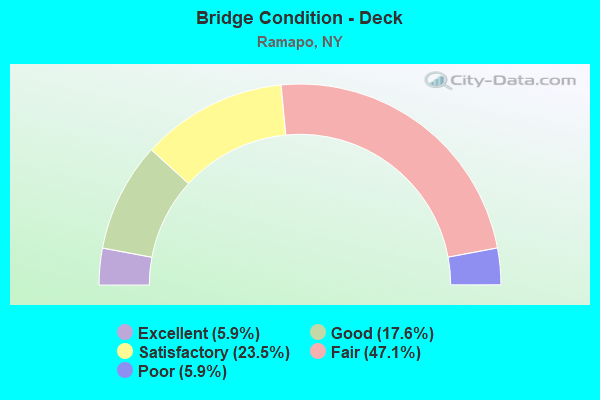
- Bridge Condition - Deck
- 5.9%Excellent
- 17.6%Good
- 23.5%Satisfactory
- 47.1%Fair
- 5.9%Poor
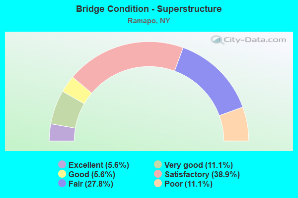
- Bridge Condition - Superstructure
- 5.6%Excellent
- 11.1%Very good
- 5.6%Good
- 38.9%Satisfactory
- 27.8%Fair
- 11.1%Poor
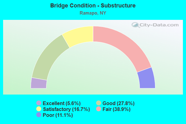
- Bridge Condition - Substructure
- 5.6%Excellent
- 27.8%Good
- 16.7%Satisfactory
- 38.9%Fair
- 11.1%Poor
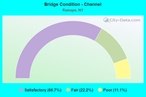
- Bridge Condition - Channel
- 66.7%Satisfactory
- 22.2%Fair
- 11.1%Poor
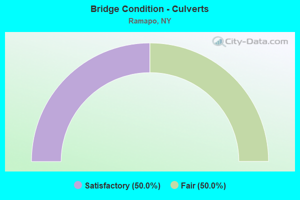
- Bridge Condition - Culverts
- 50.0%Satisfactory
- 50.0%Fair
Find on map >> Show street view
Structure Number: 102563, Location: JCT RTE 45+PIP (Lat: 41.171925, Lng: -74.032814), Route carried "on" structure: State highway 45, Year Built: 1955, Status: Open, Structure Length: 3.72m (12.20ft), Average Daily Traffic: 9,174 (year 2018), Truck Traffic: 6%, Average Future Daily Traffic: 9,217 (year 2040), Design Load: H 20, Features Intersected: 987C 987C85011132, RTE 9
Minimum Vertical Clearance: 30+ m (98+ ft), Kilometerpoint: 12.035, Lanes on structure: 3, Lanes under structure: 4, Base Highway Network: Yes, Owner: State Park, Forest, or Reservation Agency, Maintenance Responsibility: State Highway Agency, Approaching Roadway Width: 10.4m (34.1ft), Skew: 3 degrees, Material/Design: Concrete continuous, Design/Construction: Frame, Number Of Spans In Main Unit: 2, Length of Maximum Span: 17.6m (57.7ft), Curb-To-Curb Width: 12.2m (40.0ft), Out-to-Out Width: 14.3m (46.9ft)
Condition: Superstructure: Fair, Substructure: Fair, Operating Rating: 53.0 metric tons, Method Used To Determine Operating Rating: Field evaluation and documented engineering judgment, Inventory Rating: 13.4 metric tons, Method Used To Determine Inventory Rating: Field evaluation and documented engineering judgment, Structural Evaluation: High priority of corrective action, Deck Geometry: Meets minimum limits, Underclear: High priority of corrective action, Approach Roadway Alignment: Equal to present desirable criteria, Length Of Structure Improvement: 3.71m (12.17ft), Designated Inspection Frequency: Every 24 months, Inspection Date: September 2020, Bridge Improvement Cost: $2,758,000, Roadway Improvement Cost: $1,615,000, Total Project Cost: $4,373,000 ( Estimate for 2021)
Find on map >> Show street view
Structure Number: 102764, Location: 0.8 MI W JCT RTS 59+306 (Lat: 41.108878, Lng: -74.084433), Route carried "on" structure: State highway 59, Year Built: 1954, Status: Open, Structure Length: 9.20m (30.18ft), Average Daily Traffic: 14,949 (year 2018), Truck Traffic: 6%, Average Future Daily Traffic: 15,019 (year 2040), Design Load: HS 20+Mod, Features Intersected: 87IX South Bound, RTE I8
Minimum Vertical Clearance: 30+ m (98+ ft), Kilometerpoint: 8.431, Lanes on structure: 4, Lanes under structure: 6, Base Highway Network: Yes, Owner: State Highway Agency, Maintenance Responsibility: State Toll Authority, Approaching Roadway Width: 21.9m (71.9ft), Skew: 4 degrees, Material/Design: Steel, Design/Construction: Stringer/Multi-beam, Number Of Spans In Main Unit: 4, Length of Maximum Span: 28.0m (91.9ft), Curb or Sidewalk Widths: Left: 0.8m (2.6ft), Right: 0.8m (2.6ft), Curb-To-Curb Width: 20.4m (66.9ft), Out-to-Out Width: 22.6m (74.1ft)
Condition: Deck: Fair, Superstructure: Fair, Substructure: Fair, Operating Rating: 58.1 metric tons, Method Used To Determine Operating Rating: Load Factor (LF), Inventory Rating: 34.5 metric tons, Method Used To Determine Inventory Rating: Load Factor (LF), Structural Evaluation: Somewhat better than minimum adequacy, Deck Geometry: Superior to present desirable criteria, Underclear: Meets minimum limits, Approach Roadway Alignment: Equal to present desirable criteria, Length Of Structure Improvement: 9.20m (30.18ft), Designated Inspection Frequency: Every 24 months, Inspection Date: June 2020, Bridge Improvement Cost: $8,184,000, Roadway Improvement Cost: $4,793,000, Total Project Cost: $12,977,000 ( Estimate for 2021), Deck Structure Type: Concrete Cast-file-Place, Wearing Surface/Protective System: Wearing Surface: Bituminous
Find on map >> Show street view
Structure Number: 102765, Location: .2 MI W JCT SH59 & SH306 (Lat: 41.107544, Lng: -74.073353), Route carried "on" structure: State highway 59, Year Built: 2006, Status: Open, Structure Length: 2.65m (8.69ft), Average Daily Traffic: 14,949 (year 2018), Truck Traffic: 6%, Average Future Daily Traffic: 15,019 (year 2040), Design Load: HS 25 or greater, Features Intersected: Metro North Railroad Aba
Minimum Vertical Clearance: 30+ m (98+ ft), Kilometerpoint: 9.429, Lanes on structure: 2, Base Highway Network: Yes, Owner: State Highway Agency, Approaching Roadway Width: 15.5m (50.9ft), Skew: 23 degrees, Material/Design: Steel, Design/Construction: Stringer/Multi-beam, Number Of Spans In Main Unit: 1, Length of Maximum Span: 25.6m (84.0ft), Curb or Sidewalk Widths: Left: 1.6m (5.2ft), Right: 1.6m (5.2ft), Curb-To-Curb Width: 15.6m (51.2ft), Out-to-Out Width: 19.7m (64.6ft)
Condition: Deck: Satisfactory, Superstructure: Very good, Substructure: Good, Operating Rating: 86.8 metric tons, Method Used To Determine Operating Rating: Load and Resistance Factor Rating (LRFR) rating reported by rating factor(RF) method using HL-93 loadings, Inventory Rating: 67.1 metric tons, Method Used To Determine Inventory Rating: Load and Resistance Factor Rating (LRFR) rating reported by rating factor(RF) method using HL-93 loadings, Structural Evaluation: Better than present minimum criteria, Deck Geometry: Superior to present desirable criteria, Approach Roadway Alignment: Better than present minimum criteria, Length Of Structure Improvement: 2.65m (8.69ft), Designated Inspection Frequency: Every 24 months, Inspection Date: August 2020, Bridge Improvement Cost: $1,996,000, Roadway Improvement Cost: $1,169,000, Total Project Cost: $3,164,000 ( Estimate for 2021), Deck Structure Type: Concrete Cast-file-Place, Wearing Surface/Protective System: Wearing Surface: Integral Concrete, Deck Protection: Galvanized Reinforcing
Find on map >> Show street view
Structure Number: 1068749, Location: 3.3 MI N JCT PIP+RTE 304 (Lat: 41.148931, Lng: -74.025033), Route carried "on" structure: Other road 987C, Year Built: 1953, Status: Open, Structure Length: 1.74m (5.71ft), Average Daily Traffic: 47,343 (year 2011), Truck Traffic: 2%, Average Future Daily Traffic: 66,786 (year 2040), Design Load: H 20, Features Intersected: CR80-NEW HMSTD RD
Minimum Vertical Clearance: 30+ m (98+ ft), Kilometerpoint: 18.680, Lanes on structure: 4, Lanes under structure: 2, Base Highway Network: Yes, Owner: State Park, Forest, or Reservation Agency, Maintenance Responsibility: State Highway Agency, Approaching Roadway Width: 15.5m (50.9ft), Skew: 32 degrees, Material/Design: Concrete, Design/Construction: Frame, Number Of Spans In Main Unit: 1, Length of Maximum Span: 14.6m (47.9ft), Curb-To-Curb Width: 15.5m (50.9ft), Out-to-Out Width: 28.5m (93.5ft)
Condition: Deck: Satisfactory, Superstructure: Satisfactory, Substructure: Fair, Operating Rating: 57.2 metric tons, Method Used To Determine Operating Rating: Field evaluation and documented engineering judgment, Inventory Rating: 23.4 metric tons, Method Used To Determine Inventory Rating: Field evaluation and documented engineering judgment, Structural Evaluation: Somewhat better than minimum adequacy, Deck Geometry: High priority of replacement, Underclear: High priority of corrective action, Approach Roadway Alignment: Equal to present desirable criteria, Length Of Structure Improvement: 1.73m (5.68ft), Designated Inspection Frequency: Every 24 months, Inspection Date: October 2020, Bridge Improvement Cost: $2,906,000, Roadway Improvement Cost: $1,701,000, Total Project Cost: $4,607,000 ( Estimate for 2021), Wearing Surface/Protective System: Wearing Surface: Monolithic Concrete
Find on map >> Show street view
Structure Number: 10746, Location: 6.2 MI S I-87/CTY RD 106 (Lat: 41.143375, Lng: -74.181408), Route carried "on" structure: ServiceOther road , Year Built: 1992, Status: Open, Structure Length: 4.79m (15.72ft), Average Daily Traffic: 1,000 (year 2006), Truck Traffic: 99%, Average Future Daily Traffic: 7,560 (year 2026), Design Load: HS 20, Features Intersected: I-87 NB, RTE I87, Facility Carried by Structure: TANDEM TRUCK ACCES
Minimum Vertical Clearance: 30+ m (98+ ft), Kilometerpoint: 0.000, Lanes on structure: 2, Lanes under structure: 7, Toll: On Interstate toll segment, Owner: State Toll Authority, Approaching Roadway Width: 12.8m (42.0ft), Material/Design: Steel continuous, Design/Construction: Stringer/Multi-beam, Number Of Spans In Main Unit: 2, Length of Maximum Span: 25.3m (83.0ft), Curb-To-Curb Width: 12.9m (42.3ft), Out-to-Out Width: 13.9m (45.6ft)
Condition: Deck: Fair, Superstructure: Very good, Substructure: Good, Operating Rating: 46.7 metric tons, Method Used To Determine Operating Rating: Load and Resistance Factor Rating (LRFR) rating reported by rating factor(RF) method using HL-93 loadings, Inventory Rating: 36.0 metric tons, Method Used To Determine Inventory Rating: Load and Resistance Factor Rating (LRFR) rating reported by rating factor(RF) method using HL-93 loadings, Structural Evaluation: Better than present minimum criteria, Deck Geometry: Superior to present desirable criteria, Underclear: Meets minimum limits, Approach Roadway Alignment: Equal to present desirable criteria, Length Of Structure Improvement: 4.78m (15.68ft), Designated Inspection Frequency: Every 24 months, Inspection Date: July 2020, Bridge Improvement Cost: $3,854,000, Roadway Improvement Cost: $2,257,000, Total Project Cost: $6,110,000 ( Estimate for 2021), Deck Structure Type: Concrete Cast-file-Place, Wearing Surface/Protective System: Wearing Surface: Integral Concrete, Deck Protection: Epoxy Coated Reinforcing
Find on map >> Show street view
Structure Number: 109116, Location: 1.4MI NW JCT RT17&RR&THWY (Lat: 41.148719, Lng: -74.192672), Route carried "on" structure: County highway , Year Built: 1967, Status: Open, Structure Length: 6.04m (19.82ft), Average Daily Traffic: 10,576 (year 2017), Truck Traffic: 6%, Average Future Daily Traffic: 12,847 (year 2040), Design Load: HS 20, Features Intersected: 17 17 85111021 SB, RTE, Facility Carried by Structure: STERLING MINE RD
Minimum Vertical Clearance: 30+ m (98+ ft), Kilometerpoint: 0.402, Lanes on structure: 2, Lanes under structure: 4, Owner: State Highway Agency, Approaching Roadway Width: 11.6m (38.1ft), Skew: 3 degrees, Material/Design: Steel, Design/Construction: Stringer/Multi-beam, Number Of Spans In Main Unit: 3, Length of Maximum Span: 29.3m (96.1ft), Curb or Sidewalk Widths: Left: 0.5m (1.6ft), Right: 0.5m (1.6ft), Curb-To-Curb Width: 8.5m (27.9ft), Out-to-Out Width: 10.1m (33.1ft)
Condition: Deck: Satisfactory, Superstructure: Satisfactory, Substructure: Poor, Operating Rating: 59.0 metric tons, Method Used To Determine Operating Rating: Load and Resistance Factor Rating (LRFR) rating reported by rating factor(RF) method using HL-93 loadings, Inventory Rating: 45.4 metric tons, Method Used To Determine Inventory Rating: Load and Resistance Factor Rating (LRFR) rating reported by rating factor(RF) method using HL-93 loadings, Structural Evaluation: Meets minimum limits, Deck Geometry: Meets minimum limits, Underclear: Meets minimum limits, Approach Roadway Alignment: Equal to present desirable criteria, Length Of Structure Improvement: 6.03m (19.78ft), Designated Inspection Frequency: Every 24 months, Inspection Date: July 2021, Bridge Improvement Cost: $2,472,000, Roadway Improvement Cost: $1,448,000, Total Project Cost: $3,920,000 ( Estimate for 2021), Deck Structure Type: Concrete Cast-file-Place, Wearing Surface/Protective System: Wearing Surface: Bituminous
Find on map >> Show street view
Structure Number: 222415, Location: 3.8 MI SE OF SUFFERN (Lat: 41.080778, Lng: -74.083169), Route carried "on" structure: Other road , Year Built: 1989, Status: Open, Structure Length: 0.82m (2.69ft), Average Daily Traffic: 1,202 (year 2015), Truck Traffic: 6%, Average Future Daily Traffic: 1,487 (year 2040), Design Load: HS 20, Features Intersected: SADDLE RIVER, Facility Carried by Structure: HILLSIDE AVENUE
Minimum Vertical Clearance: 30+ m (98+ ft), Kilometerpoint: 0.145, Lanes on structure: 2, Owner: County Highway Agency, Approaching Roadway Width: 9.1m (29.9ft), Skew: 2 degrees, Material/Design: Concrete, Design/Construction: Culvert, Number Of Spans In Main Unit: 1, Length of Maximum Span: 6.7m (22.0ft), Curb-To-Curb Width: 9.1m (29.9ft), Out-to-Out Width: 9.8m (32.2ft)
Condition: Channel: Satisfactory, Culverts: Satisfactory, Operating Rating: 57.0 metric tons, Method Used To Determine Operating Rating: Load and Resistance Factor Rating (LRFR) rating reported by rating factor(RF) method using HL-93 loadings, Inventory Rating: 44.1 metric tons, Method Used To Determine Inventory Rating: Load and Resistance Factor Rating (LRFR) rating reported by rating factor(RF) method using HL-93 loadings, Structural Evaluation: Equal to present minimum criteria, Deck Geometry: Somewhat better than minimum adequacy, Waterway Adequacy: Meets minimum limits, Approach Roadway Alignment: Equal to present desirable criteria, Length Of Structure Improvement: 0.82m (2.69ft), Designated Inspection Frequency: Every 24 months, Inspection Date: June 2021, Bridge Improvement Cost: $333,000, Roadway Improvement Cost: $195,000, Total Project Cost: $528,000 ( Estimate for 2021), Wearing Surface/Protective System: Wearing Surface: Monolithic Concrete
Find on map >> Show street view
Structure Number: 226996, Location: 1 MI NE JCT US202 & Rt 88 (Lat: 41.150197, Lng: -74.090536), Route carried "on" structure: City street , Year Built: 2010, Status: Open, Structure Length: 0.94m (3.08ft), Average Daily Traffic: 1,957 (year 2016), Truck Traffic: 4%, Average Future Daily Traffic: 2,421 (year 2040), Features Intersected: WILLOW TREE BROOK, Facility Carried by Structure: WILLOW TREE ROAD
Minimum Vertical Clearance: 30+ m (98+ ft), Kilometerpoint: 0.016, Lanes on structure: 2, Owner: Town or Township Highway Agency, Approaching Roadway Width: 7.6m (24.9ft), Skew: 4 degrees, Material/Design: Concrete, Design/Construction: Frame, Number Of Spans In Main Unit: 1, Length of Maximum Span: 9.1m (29.9ft), Curb or Sidewalk Widths: Left: 0.9m (3.0ft), Right: 0.9m (3.0ft), Curb-To-Curb Width: 6.3m (20.7ft), Out-to-Out Width: 9.2m (30.2ft)
Condition: Deck: Good, Superstructure: Good, Substructure: Good, Channel: Satisfactory, Operating Rating: 52.6 metric tons, Method Used To Determine Operating Rating: Load Factor (LF), Inventory Rating: 31.8 metric tons, Method Used To Determine Inventory Rating: Load Factor (LF), Structural Evaluation: Better than present minimum criteria, Deck Geometry: High priority of replacement, Waterway Adequacy: Equal to present desirable criteria, Approach Roadway Alignment: Equal to present desirable criteria, Length Of Structure Improvement: 0.94m (3.08ft), Designated Inspection Frequency: Every 24 months, Inspection Date: October 2020, Bridge Improvement Cost: $431,000, Roadway Improvement Cost: $252,000, Total Project Cost: $683,000 ( Estimate for 2021), Wearing Surface/Protective System: Wearing Surface: Bituminous
Find on map >> Show street view
Structure Number: 336909, Location: 0.6 MI EAST OF US 202 (Lat: 41.150408, Lng: -74.096389), Route carried "on" structure: County highway , Year Built: 1963, Status: Open, Structure Length: 1.52m (4.99ft), Average Daily Traffic: 4,265 (year 2020), Truck Traffic: 6%, Average Future Daily Traffic: 5,181 (year 2040), Design Load: HS 20, Features Intersected: WILLOW TREE BROOK, Facility Carried by Structure: GRANDVIEW AVENUE
Minimum Vertical Clearance: 30+ m (98+ ft), Kilometerpoint: 1.046, Lanes on structure: 2, Owner: County Highway Agency, Approaching Roadway Width: 9.8m (32.2ft), Skew: 3 degrees, Material/Design: Steel, Design/Construction: Culvert, Number Of Spans In Main Unit: 3, Length of Maximum Span: 2.1m (6.9ft)
Condition: Channel: Poor, Culverts: Fair, Operating Rating: 73.9 metric tons, Method Used To Determine Operating Rating: Field evaluation and documented engineering judgment, Inventory Rating: 29.4 metric tons, Method Used To Determine Inventory Rating: Field evaluation and documented engineering judgment, Structural Evaluation: Somewhat better than minimum adequacy, Waterway Adequacy: Meets minimum limits, Approach Roadway Alignment: Equal to present desirable criteria, Length Of Structure Improvement: 1.52m (4.99ft), Designated Inspection Frequency: Every 24 months, Inspection Date: May 2020, Bridge Improvement Cost: $510,000, Roadway Improvement Cost: $299,000, Total Project Cost: $809,000 ( Estimate for 2021), Wearing Surface/Protective System: Wearing Surface: Bituminous
Find on map >> Show street view
Structure Number: 33691, Location: 0.8 MI WEST OF SR 45 (Lat: 41.167283, Lng: -74.048833), Route carried "on" structure: County highway , Year Built: 1963, Status: Open, Structure Length: 0.85m (2.79ft), Average Daily Traffic: 4,293 (year 2015), Truck Traffic: 8%, Average Future Daily Traffic: 5,215 (year 2040), Design Load: HS 20, Features Intersected: MINISCEONGO CREEK, Facility Carried by Structure: POMONA ROAD
Minimum Vertical Clearance: 30+ m (98+ ft), Kilometerpoint: 1.464, Lanes on structure: 2, Owner: County Highway Agency, Approaching Roadway Width: 9.1m (29.9ft), Skew: 4 degrees, Material/Design: Concrete, Design/Construction: Culvert, Number Of Spans In Main Unit: 3, Length of Maximum Span: 1.5m (4.9ft), Curb or Sidewalk Widths: Left: 3.7m (12.1ft), Right: 0.0m
Condition: Channel: Fair, Culverts: Satisfactory, Operating Rating: 73.5 metric tons, Method Used To Determine Operating Rating: Field evaluation and documented engineering judgment, Inventory Rating: 29.4 metric tons, Method Used To Determine Inventory Rating: Field evaluation and documented engineering judgment, Structural Evaluation: Equal to present minimum criteria, Waterway Adequacy: Meets minimum limits, Approach Roadway Alignment: Equal to present desirable criteria, Length Of Structure Improvement: 0.85m (2.79ft), Designated Inspection Frequency: Every 24 months, Inspection Date: May 2020, Bridge Improvement Cost: $220,000, Roadway Improvement Cost: $129,000, Total Project Cost: $348,000 ( Estimate for 2021), Wearing Surface/Protective System: Wearing Surface: Bituminous
Find on map >> Show street view
Structure Number: 336998, Location: .5 MI E JCT US202 & CR80 (Lat: 41.150528, Lng: -74.097936), Route carried "on" structure: County highway , Year Built: 1963, Status: Open, Structure Length: 1.04m (3.41ft), Average Daily Traffic: 4,265 (year 2020), Truck Traffic: 6%, Average Future Daily Traffic: 5,181 (year 2040), Design Load: HS 20, Features Intersected: SPOOK ROCK BROOK, Facility Carried by Structure: GRANDVIEW AVENUE
Minimum Vertical Clearance: 30+ m (98+ ft), Kilometerpoint: 0.917, Lanes on structure: 2, Owner: County Highway Agency, Approaching Roadway Width: 9.1m (29.9ft), Material/Design: Steel, Design/Construction: Culvert, Number Of Spans In Main Unit: 3, Length of Maximum Span: 1.8m (5.9ft)
Condition: Channel: Satisfactory, Culverts: Fair, Operating Rating: 73.3 metric tons, Method Used To Determine Operating Rating: Field evaluation and documented engineering judgment, Inventory Rating: 19.6 metric tons, Method Used To Determine Inventory Rating: Field evaluation and documented engineering judgment, Structural Evaluation: Somewhat better than minimum adequacy, Waterway Adequacy: Somewhat better than minimum adequacy, Approach Roadway Alignment: Equal to present desirable criteria, Length Of Structure Improvement: 1.03m (3.38ft), Designated Inspection Frequency: Every 24 months, Inspection Date: October 2021, Bridge Improvement Cost: $267,000, Roadway Improvement Cost: $156,000, Total Project Cost: $423,000 ( Estimate for 2021)
Find on map >> Show street view
Structure Number: 5014081, Location: JCT I87 AND SH 17 (Lat: 41.139519, Lng: -74.170361), Route carried "on" structure: Interstate 87, Year Built: 1953, Status: Open, Structure Length: 23.16m (75.98ft), Average Daily Traffic: 43,882 (year 2012), Truck Traffic: 15%, Design Load: HS 20+Mod, Features Intersected: RTE 17, RAMAPO RIVER, MN
Minimum Vertical Clearance: 30+ m (98+ ft), Kilometerpoint: 51.150, Lanes on structure: 3, Lanes under structure: 4, Base Highway Network: Yes, Toll: On toll road, Owner: State Toll Authority, Approaching Roadway Width: 16.2m (53.1ft), Skew: 3 degrees, Material/Design: Steel, Design/Construction: Stringer/Multi-beam, Number Of Spans In Main Unit: 7, Length of Maximum Span: 37.8m (124.0ft), Curb-To-Curb Width: 16.1m (52.8ft), Out-to-Out Width: 17.1m (56.1ft)
Condition: Deck: Fair, Superstructure: Fair, Substructure: Satisfactory, Channel: Satisfactory, Operating Rating: 63.5 metric tons, Method Used To Determine Operating Rating: Load Factor (LF), Inventory Rating: 32.7 metric tons, Method Used To Determine Inventory Rating: Load Factor (LF), Structural Evaluation: Somewhat better than minimum adequacy, Deck Geometry: Equal to present minimum criteria, Underclear: High priority of corrective action, Waterway Adequacy: High priority of replacement, Approach Roadway Alignment: Equal to present desirable criteria, Length Of Structure Improvement: 23.16m (75.98ft), Designated Inspection Frequency: Every 24 months, Inspection Date: August 2021, Bridge Improvement Cost: $14,866,000, Roadway Improvement Cost: $8,705,000, Total Project Cost: $23,571,000 ( Estimate for 2021), Deck Structure Type: Concrete Cast-file-Place, Wearing Surface/Protective System: Wearing Surface: Bituminous, Membrane: Other
Find on map >> Show street view
Structure Number: 5014082, Location: JCT I87 AND SH 17 (Lat: 41.139442, Lng: -74.170011), Route carried "on" structure: Interstate 87, Year Built: 1953, Status: Open, Structure Length: 24.35m (79.89ft), Average Daily Traffic: 33,196 (year 2019), Truck Traffic: 16%, Average Future Daily Traffic: 56,213 (year 2040), Design Load: HS 20+Mod, Features Intersected: RTE 17, RAMAPO RIVER, Me
Minimum Vertical Clearance: 30+ m (98+ ft), Kilometerpoint: 27.192, Lanes on structure: 4, Lanes under structure: 4, Base Highway Network: Yes, Toll: On Interstate toll segment, Owner: State Toll Authority, Approaching Roadway Width: 19.2m (63.0ft), Skew: 3 degrees, Material/Design: Steel, Design/Construction: Stringer/Multi-beam, Number Of Spans In Main Unit: 7, Length of Maximum Span: 37.8m (124.0ft), Curb-To-Curb Width: 17.4m (57.1ft), Out-to-Out Width: 20.2m (66.3ft)
Condition: Deck: Fair, Superstructure: Fair, Substructure: Fair, Channel: Satisfactory, Operating Rating: 63.5 metric tons, Method Used To Determine Operating Rating: Load Factor (LF), Inventory Rating: 32.7 metric tons, Method Used To Determine Inventory Rating: Load Factor (LF), Structural Evaluation: Somewhat better than minimum adequacy, Deck Geometry: Meets minimum limits, Underclear: Meets minimum limits, Waterway Adequacy: Equal to present minimum criteria, Approach Roadway Alignment: Equal to present desirable criteria, Length Of Structure Improvement: 24.35m (79.89ft), Designated Inspection Frequency: Every 24 months, Inspection Date: August 2021, Bridge Improvement Cost: $18,974,000, Roadway Improvement Cost: $11,111,000, Total Project Cost: $30,085,000 ( Estimate for 2021), Deck Structure Type: Concrete Cast-file-Place, Wearing Surface/Protective System: Wearing Surface: Bituminous, Membrane: Other
Find on map >> Show street view
Structure Number: 5514071, Location: 0.5 MI E JCT I87 & NY-59 (Lat: 41.104042, Lng: -74.076914), Route carried "on" structure: Interstate 87, Year Built: 1954, Year Reconstructed: 1983, Status: Open, Structure Length: 4.66m (15.29ft), Average Daily Traffic: 52,345 (year 2014), Truck Traffic: 15%, Design Load: HS 20+Mod, Features Intersected: NJ Transit (Aban)
Minimum Vertical Clearance: 32.69m (107.25ft), Kilometerpoint: 41.078, Lanes on structure: 3, Base Highway Network: Yes, Toll: On Interstate toll segment, Owner: State Toll Authority, Approaching Roadway Width: 17.1m (56.1ft), Skew: 1 degrees, Material/Design: Steel continuous, Design/Construction: Stringer/Multi-beam, Number Of Spans In Main Unit: 3, Length of Maximum Span: 18.3m (60.0ft), Curb-To-Curb Width: 16.9m (55.4ft), Out-to-Out Width: 17.6m (57.7ft)
Condition: Deck: Fair, Superstructure: Satisfactory, Substructure: Fair, Operating Rating: 59.9 metric tons, Method Used To Determine Operating Rating: Load Factor (LF), Inventory Rating: 35.4 metric tons, Method Used To Determine Inventory Rating: Load Factor (LF), Structural Evaluation: Somewhat better than minimum adequacy, Deck Geometry: Equal to present minimum criteria, Approach Roadway Alignment: Equal to present desirable criteria, Length Of Structure Improvement: 4.66m (15.29ft), Designated Inspection Frequency: Every 24 months, Inspection Date: May 2020, Bridge Improvement Cost: $3,571,000, Roadway Improvement Cost: $2,091,000, Total Project Cost: $5,662,000 ( Estimate for 2021), Deck Structure Type: Concrete Cast-file-Place, Wearing Surface/Protective System: Wearing Surface: Bituminous
Find on map >> Show street view
Structure Number: 5514072, Location: 0.5 MI E JCT I87 & NY-59 (Lat: 41.104186, Lng: -74.076761), Route carried "on" structure: Interstate 87, Year Built: 1954, Year Reconstructed: 1983, Status: Open, Structure Length: 4.66m (15.29ft), Average Daily Traffic: 40,264 (year 2018), Truck Traffic: 14%, Average Future Daily Traffic: 68,182 (year 2040), Design Load: HS 20+Mod, Features Intersected: NJ Transit (Aban)
Minimum Vertical Clearance: 30+ m (98+ ft), Kilometerpoint: 17.216, Lanes on structure: 3, Base Highway Network: Yes, Toll: On Interstate toll segment, Owner: State Toll Authority, Approaching Roadway Width: 17.1m (56.1ft), Skew: 1 degrees, Material/Design: Steel continuous, Design/Construction: Stringer/Multi-beam, Number Of Spans In Main Unit: 3, Length of Maximum Span: 18.3m (60.0ft), Curb-To-Curb Width: 16.9m (55.4ft), Out-to-Out Width: 17.6m (57.7ft)
Condition: Deck: Fair, Superstructure: Satisfactory, Substructure: Satisfactory, Operating Rating: 59.9 metric tons, Method Used To Determine Operating Rating: Load Factor (LF), Inventory Rating: 35.4 metric tons, Method Used To Determine Inventory Rating: Load Factor (LF), Structural Evaluation: Equal to present minimum criteria, Deck Geometry: Equal to present minimum criteria, Approach Roadway Alignment: Equal to present desirable criteria, Length Of Structure Improvement: 4.66m (15.29ft), Designated Inspection Frequency: Every 24 months, Inspection Date: May 2020, Bridge Improvement Cost: $3,533,000, Roadway Improvement Cost: $2,069,000, Total Project Cost: $5,602,000 ( Estimate for 2021), Deck Structure Type: Concrete Cast-file-Place, Wearing Surface/Protective System: Wearing Surface: Bituminous
Find on map >> Show street view
Structure Number: 551408, Location: 3.1 MI E JCT RTS I87<202 (Lat: 41.111150, Lng: -74.089747), Route carried "on" structure: County highway , Year Built: 2021, Status: Open, Structure Length: 4.97m (16.31ft), Average Daily Traffic: 9,767 (year 2015), Truck Traffic: 5%, Average Future Daily Traffic: 12,084 (year 2040), Design Load: HL 93, Features Intersected: I-87 SB, RTE I87, Facility Carried by Structure: COLLEGE ROAD CR81
Minimum Vertical Clearance: 30+ m (98+ ft), Kilometerpoint: 3.170, Lanes on structure: 2, Lanes under structure: 6, Owner: State Toll Authority, Approaching Roadway Width: 9.4m (30.8ft), Skew: 1 degrees, Material/Design: Steel, Design/Construction: Stringer/Multi-beam, Number Of Spans In Main Unit: 2, Length of Maximum Span: 24.1m (79.1ft), Curb or Sidewalk Widths: Left: 1.6m (5.2ft), Right: 0.0m, Curb-To-Curb Width: 12.6m (41.3ft), Out-to-Out Width: 14.6m (47.9ft)
Condition: Deck: Excellent, Superstructure: Excellent, Substructure: Excellent, Inventory Rating: 80.7 metric tons, Method Used To Determine Inventory Rating: Load Factor (LF), Structural Evaluation: Superior to present desirable criteria, Deck Geometry: Somewhat better than minimum adequacy, Underclear: High priority of corrective action, Approach Roadway Alignment: Equal to present desirable criteria, Length Of Structure Improvement: 6.27m (20.57ft), Designated Inspection Frequency: Every 24 months, Inspection Date: December 2021, Bridge Improvement Cost: $2,823,000, Roadway Improvement Cost: $1,653,000, Total Project Cost: $4,475,000 ( Estimate for 2021), Deck Structure Type: Concrete Cast-file-Place, Wearing Surface/Protective System: Wearing Surface: Integral Concrete
Find on map >> Show street view
Structure Number: 5514099, Location: 2.6 MI E JCT RTS I-87&202 (Lat: 41.113403, Lng: -74.099047), Route carried "on" structure: Interstate 87, Year Built: 1953, Status: Open, Structure Length: 1.25m (4.10ft), Average Daily Traffic: 80,527 (year 2018), Truck Traffic: 14%, Average Future Daily Traffic: 136,364 (year 2040), Design Load: HS 20+Mod, Features Intersected: SPOOK ROCK RD
Minimum Vertical Clearance: 30+ m (98+ ft), Kilometerpoint: 19.421, Lanes on structure: 6, Lanes under structure: 2, Base Highway Network: Yes, Toll: On Interstate toll segment, Owner: State Toll Authority, Approaching Roadway Width: 33.5m (109.9ft), Skew: 32 degrees, Material/Design: Steel, Design/Construction: Stringer/Multi-beam, Number Of Spans In Main Unit: 1, Length of Maximum Span: 10.0m (32.8ft), Curb-To-Curb Width: 31.4m (103.0ft), Out-to-Out Width: 34.4m (112.9ft)
Condition: Deck: Fair, Superstructure: Satisfactory, Substructure: Fair, Operating Rating: 98.0 metric tons, Method Used To Determine Operating Rating: Load Factor (LF), Inventory Rating: 58.1 metric tons, Method Used To Determine Inventory Rating: Load Factor (LF), Structural Evaluation: Somewhat better than minimum adequacy, Deck Geometry: Superior to present desirable criteria, Underclear: High priority of corrective action, Approach Roadway Alignment: Equal to present desirable criteria, Length Of Structure Improvement: 1.24m (4.07ft), Designated Inspection Frequency: Every 24 months, Inspection Date: May 2021, Bridge Improvement Cost: $4,579,000, Roadway Improvement Cost: $2,681,000, Total Project Cost: $7,260,000 ( Estimate for 2021), Deck Structure Type: Concrete Cast-file-Place, Wearing Surface/Protective System: Wearing Surface: Bituminous
Find on map >> Show street view
Structure Number: 55141, Location: 1.9 MI E JCT I-87 & 202 (Lat: 41.116422, Lng: -74.112714), Route carried "on" structure: County highway , Year Built: 1956, Status: Open, Structure Length: 7.04m (23.10ft), Average Daily Traffic: 22,625 (year 2014), Truck Traffic: 5%, Average Future Daily Traffic: 27,484 (year 2040), Design Load: HS 20+Mod, Features Intersected: 87IX SB, RTE I87, Facility Carried by Structure: N. AIRMONT ROAD EB
Minimum Vertical Clearance: 30+ m (98+ ft), Kilometerpoint: 2.558, Lanes on structure: 3, Lanes under structure: 6, Owner: State Toll Authority, Approaching Roadway Width: 12.8m (42.0ft), Skew: 2 degrees, Material/Design: Steel, Design/Construction: Stringer/Multi-beam, Number Of Spans In Main Unit: 4, Length of Maximum Span: 19.2m (63.0ft), Curb or Sidewalk Widths: Left: 1.1m (3.6ft), Right: 0.8m (2.6ft), Curb-To-Curb Width: 9.4m (30.8ft), Out-to-Out Width: 11.6m (38.1ft)
Condition: Deck: Good, Superstructure: Satisfactory, Substructure: Fair, Operating Rating: 45.4 metric tons, Method Used To Determine Operating Rating: Load Factor (LF), Inventory Rating: 23.6 metric tons, Method Used To Determine Inventory Rating: Load Factor (LF), Structural Evaluation: Somewhat better than minimum adequacy, Deck Geometry: High priority of replacement, Underclear: High priority of corrective action, Approach Roadway Alignment: Equal to present minimum criteria, Length Of Structure Improvement: 7.04m (23.10ft), Designated Inspection Frequency: Every 24 months, Inspection Date: August 2021, Bridge Improvement Cost: $3,113,000, Roadway Improvement Cost: $1,823,000, Total Project Cost: $4,936,000 ( Estimate for 2021), Deck Structure Type: Concrete Cast-file-Place, Wearing Surface/Protective System: Wearing Surface: Bituminous, Membrane: Other
Find on map >> Show street view
Structure Number: 551410A, Location: AIRMONT RD & I87 NYS TWY (Lat: 41.116444, Lng: -74.112969), Route carried "on" structure: County highway , Year Built: 1993, Status: Open, Structure Length: 5.36m (17.59ft), Average Daily Traffic: 22,625 (year 2014), Truck Traffic: 5%, Average Future Daily Traffic: 27,484 (year 2040), Design Load: HS 20+Mod, Features Intersected: 87IX, RTE I87, Facility Carried by Structure: AIRMONT ROAD SB
Minimum Vertical Clearance: 30+ m (98+ ft), Kilometerpoint: 2.558, Lanes on structure: 4, Lanes under structure: 6, Owner: County Highway Agency, Approaching Roadway Width: 16.8m (55.1ft), Skew: 2 degrees, Material/Design: Steel continuous, Design/Construction: Stringer/Multi-beam, Number Of Spans In Main Unit: 2, Length of Maximum Span: 25.9m (85.0ft), Curb or Sidewalk Widths: Left: 1.5m (4.9ft), Right: 0.0m, Curb-To-Curb Width: 15.2m (49.9ft), Out-to-Out Width: 17.7m (58.1ft)
Condition: Deck: Good, Superstructure: Satisfactory, Substructure: Good, Operating Rating: 58.1 metric tons, Method Used To Determine Operating Rating: Load Factor (LF), Inventory Rating: 34.5 metric tons, Method Used To Determine Inventory Rating: Load Factor (LF), Structural Evaluation: Equal to present minimum criteria, Deck Geometry: High priority of corrective action, Underclear: High priority of corrective action, Approach Roadway Alignment: Equal to present desirable criteria, Length Of Structure Improvement: 5.36m (17.59ft), Designated Inspection Frequency: Every 24 months, Inspection Date: October 2020, Bridge Improvement Cost: $4,931,000, Roadway Improvement Cost: $2,888,000, Total Project Cost: $7,819,000 ( Estimate for 2021), Deck Structure Type: Concrete Cast-file-Place, Wearing Surface/Protective System: Wearing Surface: Integral Concrete, Deck Protection: Epoxy Coated Reinforcing
Find on map >> Show street view
Structure Number: 5514439, Location: 1.2 MI W JCT SH 45 & I87 (Lat: 41.102072, Lng: -74.069303), Route carried "on" structure: Interstate 87, Year Built: 1954, Year Reconstructed: 1983, Status: Open, Structure Length: 4.85m (15.91ft), Average Daily Traffic: 80,527 (year 2018), Truck Traffic: 14%, Average Future Daily Traffic: 136,364 (year 2040), Design Load: H 20, Features Intersected: SADDLE RV RD-CR73
Minimum Vertical Clearance: 32.69m (107.25ft), Kilometerpoint: 16.557, Lanes on structure: 6, Lanes under structure: 2, Toll: On Interstate toll segment, Owner: State Toll Authority, Approaching Roadway Width: 31.7m (104.0ft), Skew: 32 degrees, Material/Design: Steel, Design/Construction: Stringer/Multi-beam, Number Of Spans In Main Unit: 3, Length of Maximum Span: 18.0m (59.1ft), Curb-To-Curb Width: 31.1m (102.0ft), Out-to-Out Width: 34.1m (111.9ft)
Condition: Deck: Fair, Superstructure: Poor, Substructure: Good, Operating Rating: 59.9 metric tons, Method Used To Determine Operating Rating: Load Factor (LF), Inventory Rating: 35.4 metric tons, Method Used To Determine Inventory Rating: Load Factor (LF), Structural Evaluation: Meets minimum limits, Deck Geometry: Superior to present desirable criteria, Underclear: Meets minimum limits, Approach Roadway Alignment: Equal to present minimum criteria, Length Of Structure Improvement: 4.84m (15.88ft), Designated Inspection Frequency: Every 24 months, Inspection Date: April 2021, Bridge Improvement Cost: $6,712,000, Roadway Improvement Cost: $3,931,000, Total Project Cost: $10,643,000 ( Estimate for 2021), Deck Structure Type: Concrete Cast-file-Place, Wearing Surface/Protective System: Wearing Surface: Bituminous
Find on map >> Show street view
Structure Number: 552139, Location: 1.8 MI NE OF SLOATSBURG (Lat: 41.175014, Lng: -74.167017), Route carried "on" structure: Other road 987E, Year Built: 1961, Status: Open, Structure Length: 1.52m (4.99ft), Average Daily Traffic: 989 (year 2014), Truck Traffic: 2%, Average Future Daily Traffic: 1,201 (year 2040), Features Intersected: STONY BROOK
Minimum Vertical Clearance: 30+ m (98+ ft), Kilometerpoint: 1.368, Lanes on structure: 2, Base Highway Network: Yes, Owner: State Park, Forest, or Reservation Agency, Approaching Roadway Width: 12.2m (40.0ft), Material/Design: Steel, Design/Construction: Stringer/Multi-beam, Number Of Spans In Main Unit: 1, Length of Maximum Span: 13.4m (44.0ft), Curb-To-Curb Width: 12.2m (40.0ft), Out-to-Out Width: 13.8m (45.3ft)
Condition: Deck: Satisfactory, Superstructure: Fair, Substructure: Satisfactory, Channel: Satisfactory, Operating Rating: 59.9 metric tons, Method Used To Determine Operating Rating: Load Factor (LF), Inventory Rating: 35.4 metric tons, Method Used To Determine Inventory Rating: Load Factor (LF), Structural Evaluation: Somewhat better than minimum adequacy, Deck Geometry: Equal to present desirable criteria, Waterway Adequacy: Superior to present desirable criteria, Approach Roadway Alignment: Equal to present desirable criteria, Length Of Structure Improvement: 1.52m (4.99ft), Designated Inspection Frequency: Every 24 months, Inspection Date: June 2021, Bridge Improvement Cost: $1,512,000, Roadway Improvement Cost: $886,000, Total Project Cost: $2,398,000 ( Estimate for 2021), Deck Structure Type: Concrete Cast-file-Place, Wearing Surface/Protective System: Wearing Surface: Bituminous
Find on map >> Show street view
Structure Number: 55214, Location: 3.5 MI NE OF SLOATSBURG (Lat: 41.191139, Lng: -74.139847), Route carried "on" structure: State highway 987E, Year Built: 1924, Year Reconstructed: 1981, Status: Open, Structure Length: 5.91m (19.39ft), Average Daily Traffic: 989 (year 2014), Truck Traffic: 2%, Average Future Daily Traffic: 1,201 (year 2040), Design Load: HS 20+Mod, Features Intersected: LAKE SEBAGO DAM
Minimum Vertical Clearance: 30+ m (98+ ft), Kilometerpoint: 4.344, Lanes on structure: 2, Base Highway Network: Yes, Owner: State Park, Forest, or Reservation Agency, Approaching Roadway Width: 8.5m (27.9ft), Material/Design: Concrete continuous, Design/Construction: Slab, Number Of Spans In Main Unit: 19, Length of Maximum Span: 3.6m (11.8ft), Curb or Sidewalk Widths: Left: 1.2m (3.9ft), Right: 1.2m (3.9ft), Curb-To-Curb Width: 7.9m (25.9ft), Out-to-Out Width: 11.0m (36.1ft)
Condition: Deck: Poor, Superstructure: Poor, Substructure: Poor, Channel: Fair, Operating Rating: 74.5 metric tons, Method Used To Determine Operating Rating: Field evaluation and documented engineering judgment, Inventory Rating: 29.4 metric tons, Method Used To Determine Inventory Rating: Field evaluation and documented engineering judgment, Structural Evaluation: Meets minimum limits, Deck Geometry: Somewhat better than minimum adequacy, Waterway Adequacy: Somewhat better than minimum adequacy, Approach Roadway Alignment: Equal to present desirable criteria, Length Of Structure Improvement: 5.91m (19.39ft), Designated Inspection Frequency: Every 24 months, Inspection Date: April 2020, Bridge Improvement Cost: $1,614,000, Roadway Improvement Cost: $945,000, Total Project Cost: $2,560,000 ( Estimate for 2021), Wearing Surface/Protective System: Wearing Surface: Bituminous, Membrane: Epoxy
Find on map >> Show street view
Structure Number: 102563, Location: JCT RTE 45+PIP (Lat: 41.171925, Lng: -74.032814), Route carried "under" structure: Other road 987C, Year Built: 1955, Structure Length: 0. m, Average Daily Traffic: 23,000 (year 1977), Features Intersected: 987C 987C85011132, RTE 9, Facility Carried by Structure: RTE 45
Minimum Vertical Clearance: 4.57m (14.99ft), Kilometerpoint: 21.448, Lanes on structure: 3, Lanes under structure: 2, Material/Design: Concrete continuous, Design/Construction: Frame, Length of Maximum Span: 17.6m (57.7ft)
Find on map >> Show street view
Structure Number: 102764, Location: 0.8 MI W JCT RTS 59+306 (Lat: 41.108878, Lng: -74.084433), Route carried "under" structure: Interstate 87, Year Built: 1954, Structure Length: 0. m, Average Daily Traffic: 44,700 (year 1971), Features Intersected: 87IX South Bound, RTE I8, Facility Carried by Structure: RTE 59
Minimum Vertical Clearance: 5.03m (16.50ft), Kilometerpoint: 41.898, Lanes on structure: 4, Lanes under structure: 3, Toll: On Interstate toll segment, Material/Design: Steel, Design/Construction: Stringer/Multi-beam, Length of Maximum Span: 28.0m (91.9ft)
Find on map >> Show street view
Structure Number: 1068749, Location: 3.3 MI N JCT PIP+RTE 304 (Lat: 41.148931, Lng: -74.025033), Route carried "under" structure: County highway , Year Built: 1953, Structure Length: 0. m, Average Daily Traffic: 15,687 (year 2010), Truck Traffic: 5%, Features Intersected: CR80-NEW HMSTD RD, Facility Carried by Structure: RTE 987C
Minimum Vertical Clearance: 4.31m (14.14ft), Kilometerpoint: 0.000, Lanes on structure: 4, Lanes under structure: 2, Material/Design: Concrete, Design/Construction: Frame, Length of Maximum Span: 14.6m (47.9ft)
Find on map >> Show street view
Structure Number: 10746, Location: 6.2 MI S I-87/CTY RD 106 (Lat: 41.143375, Lng: -74.181408), Route carried "under" structure: Interstate 87, Year Built: 1992, Structure Length: 0. m, Average Daily Traffic: 103,396 (year 2010), Features Intersected: I-87 NB, RTE I87, Facility Carried by Structure: TANDEM TRUCK ACCES
Minimum Vertical Clearance: 5.72m (18.77ft), Kilometerpoint: 52.148, Lanes on structure: 2, Lanes under structure: 3, Toll: On Interstate toll segment, Material/Design: Steel continuous, Design/Construction: Stringer/Multi-beam, Length of Maximum Span: 25.3m (83.0ft)
Find on map >> Show street view
Structure Number: 109116, Location: 1.4MI NW JCT RT17&RR&THWY (Lat: 41.148719, Lng: -74.192672), Route carried "under" structure: State highway 17, Year Built: 1967, Structure Length: 0. m, Average Daily Traffic: 13,700 (year 1970), Features Intersected: 17 17 85111021 SB, RTE, Facility Carried by Structure: STERLING MINE RD
Minimum Vertical Clearance: 4.98m (16.34ft), Kilometerpoint: 3.363, Lanes on structure: 2, Lanes under structure: 2, Material/Design: Steel, Design/Construction: Stringer/Multi-beam, Length of Maximum Span: 29.3m (96.1ft)
Find on map >> Show street view
Structure Number: 5014081, Location: JCT I87 AND SH 17 (Lat: 41.139519, Lng: -74.170361), Route carried "under" structure: State highway 17, Year Built: 1953, Structure Length: 0. m, Average Daily Traffic: 75,420 (year 1998), Features Intersected: RTE 17, RAMAPO RIVER, MN, Facility Carried by Structure: RTE I87
Minimum Vertical Clearance: 5.72m (18.77ft), Kilometerpoint: 7.096, Lanes on structure: 3, Lanes under structure: 4, Material/Design: Steel, Design/Construction: Stringer/Multi-beam, Length of Maximum Span: 37.8m (124.0ft)
Find on map >> Show street view
Structure Number: 5014082, Location: JCT I87 AND SH 17 (Lat: 41.139442, Lng: -74.170011), Route carried "under" structure: State highway 17, Year Built: 1953, Structure Length: 0. m, Average Daily Traffic: 75,420 (year 1998), Features Intersected: RTE 17, RAMAPO RIVER, Me, Facility Carried by Structure: RTE I87
Minimum Vertical Clearance: 6.50m (21.33ft), Kilometerpoint: 7.096, Lanes on structure: 4, Lanes under structure: 4, Material/Design: Steel, Design/Construction: Stringer/Multi-beam, Length of Maximum Span: 37.8m (124.0ft)
Find on map >> Show street view
Structure Number: 551408, Location: 3.1 MI E JCT RTS I87<202 (Lat: 41.111150, Lng: -74.089747), Route carried "under" structure: Interstate 87, Year Built: 2021, Structure Length: 0. m, Average Daily Traffic: 12,000 (year 2021), Features Intersected: I-87 SB, RTE I87, Facility Carried by Structure: COLLEGE ROAD CR81
Minimum Vertical Clearance: 4.60m (15.09ft), Kilometerpoint: 42.429, Lanes on structure: 2, Lanes under structure: 3, Toll: On Interstate toll segment, Material/Design: Steel, Design/Construction: Stringer/Multi-beam, Length of Maximum Span: 24.1m (79.1ft)
Find on map >> Show street view
Structure Number: 5514099, Location: 2.6 MI E JCT RTS I-87&202 (Lat: 41.113403, Lng: -74.099047), Route carried "under" structure: County highway , Year Built: 1953, Structure Length: 0. m, Average Daily Traffic: 6,392 (year 2017), Truck Traffic: 4%, Features Intersected: SPOOK ROCK RD, Facility Carried by Structure: RTE I87
Minimum Vertical Clearance: 4.50m (14.76ft), Kilometerpoint: 3.443, Lanes on structure: 6, Lanes under structure: 2, Material/Design: Steel, Design/Construction: Stringer/Multi-beam, Length of Maximum Span: 10.0m (32.8ft)
Find on map >> Show street view
Structure Number: 55141, Location: 1.9 MI E JCT I-87 & 202 (Lat: 41.116422, Lng: -74.112714), Route carried "under" structure: Interstate 87, Year Built: 1956, Structure Length: 0. m, Average Daily Traffic: 37,142 (year 1978), Features Intersected: 87IX SB, RTE I87, Facility Carried by Structure: N. AIRMONT ROAD EB
Minimum Vertical Clearance: 6.10m (20.01ft), Kilometerpoint: 44.441, Lanes on structure: 3, Lanes under structure: 3, Toll: On Interstate toll segment, Material/Design: Steel, Design/Construction: Stringer/Multi-beam, Length of Maximum Span: 19.2m (63.0ft)
Find on map >> Show street view
Structure Number: 551410A, Location: AIRMONT RD & I87 NYS TWY (Lat: 41.116444, Lng: -74.112969), Route carried "under" structure: Interstate 87, Year Built: 1993, Structure Length: 0. m, Average Daily Traffic: 37,142 (year 1978), Features Intersected: 87IX, RTE I87, Facility Carried by Structure: AIRMONT ROAD SB
Minimum Vertical Clearance: 6.24m (20.47ft), Kilometerpoint: 44.408, Lanes on structure: 4, Lanes under structure: 3, Toll: On toll road, Material/Design: Steel continuous, Design/Construction: Stringer/Multi-beam, Length of Maximum Span: 25.9m (85.0ft)
Find on map >> Show street view
Structure Number: 5514439, Location: 1.2 MI W JCT SH 45 & I87 (Lat: 41.102072, Lng: -74.069303), Route carried "under" structure: County highway , Year Built: 1954, Structure Length: 0. m, Average Daily Traffic: 5,018 (year 2018), Truck Traffic: 5%, Features Intersected: SADDLE RV RD-CR73, Facility Carried by Structure: RTE I87
Minimum Vertical Clearance: 5.33m (17.49ft), Kilometerpoint: 3.057, Lanes on structure: 6, Lanes under structure: 2, Material/Design: Steel, Design/Construction: Stringer/Multi-beam, Length of Maximum Span: 18.0m (59.1ft)