Bridge Statistics for Ravine, Pennsylvania (PA)
Condition, Traffic, Stress, Structural Evaluation, Project Costs
- National Bridge Inventory (NBI) Statistics
- 21Number of bridges
- 105ft / 31.6mTotal length
- $3,186,000Total costs
- 130,013Total average daily traffic
- 32,754Total average daily truck traffic
- National Bridge Inventory (NBI) Registered Bridges for Ravine
- No street view available for this location
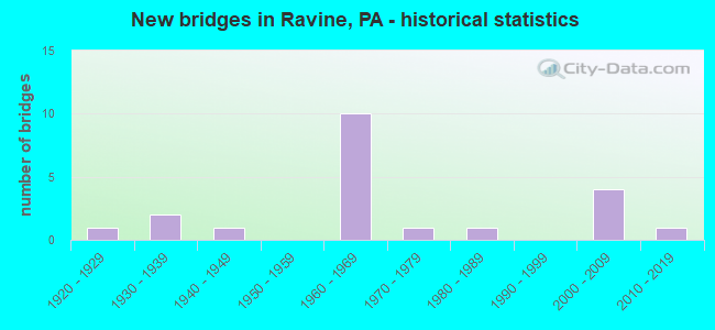
- New bridges - historical statistics
- 11920-1929
- 21930-1939
- 11940-1949
- 101960-1969
- 11970-1979
- 11980-1989
- 42000-2009
- 12010-2019

- Reconstructed bridges - Historical Statistics
- 11950-1959
- 01960-1969
- 01970-1979
- 01980-1989
- 01990-1999
- 22000-2009
- 12010-2019


- Bridge Condition - Deck
- 7.7%Very good
- 15.4%Good
- 38.5%Satisfactory
- 30.8%Fair
- 7.7%Poor

- Bridge Condition - Superstructure
- 7.7%Very good
- 23.1%Good
- 7.7%Satisfactory
- 46.2%Fair
- 15.4%Poor

- Bridge Condition - Substructure
- 30.8%Good
- 23.1%Satisfactory
- 30.8%Fair
- 15.4%Poor

- Bridge Condition - Channel
- 7.7%Good
- 15.4%Satisfactory
- 23.1%Fair
- 53.8%Poor

- Bridge Condition - Culverts
- 25.0%Very good
- 50.0%Satisfactory
- 25.0%Fair
Find on map >> Show street view
Structure Number: 3056, Location: RAVINE (Lat: 40.592775, Lng: -76.412100), Route carried "on" structure: Interstate 81, Year Built: 1969, Year Reconstructed: 2000, Status: Open, Structure Length: 3.41m (11.19ft), Average Daily Traffic: 13,367 (year 2021), Truck Traffic: 30%, Average Future Daily Traffic: 21,335 (year 2032), Design Load: HS 20+Mod, Features Intersected: SR 3013 (LR 53029)
Minimum Vertical Clearance: 30+ m (98+ ft), Kilometerpoint: 11.660, Lanes on structure: 3, Lanes under structure: 2, Base Highway Network: Yes, Owner: State Highway Agency, Approaching Roadway Width: 12.2m (40.0ft), Skew: 10 degrees, Material/Design: Prestressed concrete, Design/Construction: Box Beam or Girders - Single/Spread, Number Of Spans In Main Unit: 3, Length of Maximum Span: 15.2m (49.9ft), Curb or Sidewalk Widths: Left: 0.2m (0.7ft), Right: 0.2m (0.7ft), Curb-To-Curb Width: 15.4m (50.5ft), Out-to-Out Width: 16.8m (55.1ft)
Condition: Deck: Satisfactory, Superstructure: Fair, Substructure: Satisfactory, Operating Rating: 43.5 metric tons, Method Used To Determine Operating Rating: Load Factor (LF), Inventory Rating: 26.3 metric tons, Method Used To Determine Inventory Rating: Load Factor (LF), Structural Evaluation: Somewhat better than minimum adequacy, Deck Geometry: Somewhat better than minimum adequacy, Underclear: Equal to present minimum criteria, Approach Roadway Alignment: Equal to present desirable criteria, Length Of Structure Improvement: 4.00m (13.12ft), Designated Inspection Frequency: Every 24 months, Inspection Date: September 2020, Bridge Improvement Cost: $77,000, Roadway Improvement Cost: $226,000, Total Project Cost: $1,036,000, Deck Structure Type: Concrete Cast-file-Place, Wearing Surface/Protective System: Wearing Surface: Latex Concrete
Find on map >> Show street view
Structure Number: 30561, Location: RAVINE (Lat: 40.592614, Lng: -76.412764), Route carried "on" structure: Interstate 81, Year Built: 1969, Year Reconstructed: 2000, Status: Open, Structure Length: 3.63m (11.91ft), Average Daily Traffic: 13,829 (year 2021), Truck Traffic: 30%, Average Future Daily Traffic: 17,705 (year 2032), Design Load: HS 20+Mod, Features Intersected: SR 3013 (LR 53029)
Minimum Vertical Clearance: 30+ m (98+ ft), Kilometerpoint: 11.526, Lanes on structure: 3, Lanes under structure: 2, Base Highway Network: Yes, Owner: State Highway Agency, Approaching Roadway Width: 12.2m (40.0ft), Skew: 11 degrees, Material/Design: Prestressed concrete, Design/Construction: Box Beam or Girders - Single/Spread, Number Of Spans In Main Unit: 3, Length of Maximum Span: 16.5m (54.1ft), Curb or Sidewalk Widths: Left: 0.2m (0.7ft), Right: 0.2m (0.7ft), Curb-To-Curb Width: 15.4m (50.5ft), Out-to-Out Width: 16.6m (54.5ft)
Condition: Deck: Satisfactory, Superstructure: Fair, Substructure: Satisfactory, Operating Rating: 40.8 metric tons, Method Used To Determine Operating Rating: Load Factor (LF), Inventory Rating: 20.0 metric tons, Method Used To Determine Inventory Rating: Load Factor (LF), Structural Evaluation: Somewhat better than minimum adequacy, Deck Geometry: Somewhat better than minimum adequacy, Underclear: Somewhat better than minimum adequacy, Approach Roadway Alignment: Equal to present desirable criteria, Length Of Structure Improvement: 4.50m (14.76ft), Designated Inspection Frequency: Every 24 months, Inspection Date: September 2020, Bridge Improvement Cost: $18,000, Roadway Improvement Cost: $52,000, Total Project Cost: $241,000, Deck Structure Type: Concrete Cast-file-Place, Wearing Surface/Protective System: Wearing Surface: Latex Concrete
Find on map >> Show street view
Structure Number: 30562, Location: 0.25 MI.N.OF EXIT 104(32) (Lat: 40.596219, Lng: -76.412231), Route carried "on" structure: Interstate 81, Year Built: 1969, Status: Open, Structure Length: 0.61m (2.00ft), Average Daily Traffic: 13,367 (year 2021), Truck Traffic: 30%, Average Future Daily Traffic: 21,335 (year 2032), Design Load: HS 20, Features Intersected: RAUSCH CREEK
Minimum Vertical Clearance: 30+ m (98+ ft), Kilometerpoint: 12.464, Lanes on structure: 2, Base Highway Network: Yes, Owner: State Highway Agency, Approaching Roadway Width: 12.2m (40.0ft), Skew: 3 degrees, Material/Design: Concrete, Design/Construction: Culvert, Number Of Spans In Main Unit: 1, Length of Maximum Span: 6.1m (20.0ft)
Condition: Channel: Poor, Culverts: Satisfactory, Operating Rating: 89.8 metric tons, Method Used To Determine Operating Rating: Load Factor (LF), Inventory Rating: 89.8 metric tons, Method Used To Determine Inventory Rating: Load Factor (LF), Structural Evaluation: Equal to present minimum criteria, Waterway Adequacy: Superior to present desirable criteria, Approach Roadway Alignment: Equal to present desirable criteria, Length Of Structure Improvement: 1.20m (3.94ft), Designated Inspection Frequency: Every 24 months, Inspection Date: March 2020
Find on map >> Show street view
Structure Number: 30563, Location: 0.50 MI.N.OF EXIT 104(32) (Lat: 40.600547, Lng: -76.417078), Route carried "on" structure: Interstate 81, Year Built: 1969, Status: Open, Structure Length: 0.70m (2.30ft), Average Daily Traffic: 13,367 (year 2021), Truck Traffic: 30%, Average Future Daily Traffic: 21,335 (year 2032), Design Load: HS 20, Features Intersected: RAUSCH CREEK
Minimum Vertical Clearance: 30+ m (98+ ft), Kilometerpoint: 13.245, Lanes on structure: 2, Base Highway Network: Yes, Owner: State Highway Agency, Approaching Roadway Width: 12.5m (41.0ft), Skew: 4 degrees, Material/Design: Concrete, Design/Construction: Culvert, Number Of Spans In Main Unit: 1, Length of Maximum Span: 7.0m (23.0ft)
Condition: Channel: Fair, Culverts: Satisfactory, Operating Rating: 59.0 metric tons, Method Used To Determine Operating Rating: Load Factor (LF), Inventory Rating: 35.4 metric tons, Method Used To Determine Inventory Rating: Load Factor (LF), Structural Evaluation: Equal to present minimum criteria, Waterway Adequacy: Superior to present desirable criteria, Approach Roadway Alignment: Equal to present desirable criteria, Length Of Structure Improvement: 1.40m (4.59ft), Designated Inspection Frequency: Every 24 months, Inspection Date: March 2020
Find on map >> Show street view
Structure Number: 30564, Location: 1.1 M.N.OF EXIT 104(32) (Lat: 40.605644, Lng: -76.422975), Route carried "on" structure: Interstate 81, Year Built: 1969, Status: Open, Structure Length: 0.61m (2.00ft), Average Daily Traffic: 13,367 (year 2021), Truck Traffic: 30%, Average Future Daily Traffic: 21,335 (year 2032), Design Load: HS 20+Mod, Features Intersected: RAUSCH CREEK
Minimum Vertical Clearance: 30+ m (98+ ft), Kilometerpoint: 14.050, Lanes on structure: 2, Base Highway Network: Yes, Owner: State Highway Agency, Approaching Roadway Width: 12.8m (42.0ft), Skew: 4 degrees, Material/Design: Concrete, Design/Construction: Culvert, Number Of Spans In Main Unit: 1, Length of Maximum Span: 6.1m (20.0ft)
Condition: Channel: Fair, Culverts: Fair, Operating Rating: 78.0 metric tons, Method Used To Determine Operating Rating: Allowable Stress (AS), Structural Evaluation: High priority of corrective action, Waterway Adequacy: Superior to present desirable criteria, Approach Roadway Alignment: Equal to present desirable criteria, Length Of Structure Improvement: 1.20m (3.94ft), Designated Inspection Frequency: Every 24 months, Inspection Date: January 2020, Bridge Improvement Cost: $11,000, Roadway Improvement Cost: $32,000, Total Project Cost: $146,000
Find on map >> Show street view
Structure Number: 30613, Location: RAVINE (Lat: 40.582642, Lng: -76.406381), Route carried "on" structure: State highway 125, Year Built: 1988, Status: Open, Structure Length: 2.56m (8.40ft), Average Daily Traffic: 6,506 (year 2022), Truck Traffic: 9%, Average Future Daily Traffic: 6,839 (year 2032), Design Load: HS 25 or greater, Features Intersected: SWATARA CREEK
Minimum Vertical Clearance: 30+ m (98+ ft), Kilometerpoint: 3.909, Lanes on structure: 2, Owner: State Highway Agency, Approaching Roadway Width: 12.2m (40.0ft), Skew: 2 degrees, Material/Design: Prestressed concrete, Design/Construction: Box Beam or Girders - Multiple, Number Of Spans In Main Unit: 1, Length of Maximum Span: 25.0m (82.0ft), Curb-To-Curb Width: 12.2m (40.0ft), Out-to-Out Width: 13.0m (42.7ft)
Condition: Deck: Satisfactory, Superstructure: Satisfactory, Substructure: Good, Channel: Satisfactory, Operating Rating: 96.2 metric tons, Method Used To Determine Operating Rating: Load Factor (LF), Inventory Rating: 34.5 metric tons, Method Used To Determine Inventory Rating: Load Factor (LF), Structural Evaluation: Equal to present minimum criteria, Deck Geometry: Somewhat better than minimum adequacy, Waterway Adequacy: Superior to present desirable criteria, Approach Roadway Alignment: Equal to present desirable criteria, Length Of Structure Improvement: 3.30m (10.83ft), Designated Inspection Frequency: Every 24 months, Inspection Date: May 2021, Deck Structure Type: Concrete Cast-file-Place, Wearing Surface/Protective System: Wearing Surface: Monolithic Concrete, Deck Protection: Epoxy Coated Reinforcing
Find on map >> Show street view
Structure Number: 30614, Location: 3 MI. S. OF TREMONT (Lat: 40.597192, Lng: -76.393158), Route carried "on" structure: State highway 125, Year Built: 1930, Status: Posted for load-capacity, Structure Length: 1.13m (3.71ft), Average Daily Traffic: 3,473 (year 2022), Truck Traffic: 6%, Average Future Daily Traffic: 3,961 (year 2032), Design Load: HS 20, Features Intersected: BLACK CREEK
Minimum Vertical Clearance: 30+ m (98+ ft), Kilometerpoint: 6.204, Lanes on structure: 2, Owner: State Highway Agency, Approaching Roadway Width: 10.1m (33.1ft), Skew: 1 degrees, Material/Design: Concrete, Design/Construction: Tee Beam, Number Of Spans In Main Unit: 1, Length of Maximum Span: 10.4m (34.1ft), Curb-To-Curb Width: 12.0m (39.4ft), Out-to-Out Width: 13.1m (43.0ft)
Condition: Deck: Fair, Superstructure: Poor, Substructure: Poor, Channel: Poor, Operating Rating: 56.2 metric tons, Method Used To Determine Operating Rating: Load Factor (LF), Inventory Rating: 33.6 metric tons, Method Used To Determine Inventory Rating: Load Factor (LF), Structural Evaluation: Meets minimum limits, Deck Geometry: Somewhat better than minimum adequacy, Waterway Adequacy: Better than present minimum criteria, Approach Roadway Alignment: Equal to present desirable criteria, Length Of Structure Improvement: 1.70m (5.58ft), Designated Inspection Frequency: Every 24 months, Other Special Inspection Frequency: Every 12 months, Inspection Date: August 2021, Other Special Inspection Date: August 2021, Bridge Improvement Cost: $5,000, Roadway Improvement Cost: $16,000, Total Project Cost: $72,000, Deck Structure Type: Concrete Cast-file-Place, Wearing Surface/Protective System: Wearing Surface: Bituminous
Find on map >> Show street view
Structure Number: 30685, Location: 1 MI.EAST OF PINE GROVE (Lat: 40.564953, Lng: -76.368181), Route carried "on" structure: State highway 443, Year Built: 1920, Year Reconstructed: 1956, Status: Open, Structure Length: 3.14m (10.30ft), Average Daily Traffic: 4,429 (year 2020), Truck Traffic: 7%, Average Future Daily Traffic: 6,030 (year 2032), Design Load: HS 20, Features Intersected: SO. BR. SWATARA CREEK
Minimum Vertical Clearance: 30+ m (98+ ft), Kilometerpoint: 12.254, Lanes on structure: 2, Base Highway Network: Yes, Owner: State Highway Agency, Approaching Roadway Width: 8.5m (27.9ft), Material/Design: Concrete, Design/Construction: Arch - Deck, Number Of Spans In Main Unit: 3, Length of Maximum Span: 29.9m (98.1ft), Curb-To-Curb Width: 8.1m (26.6ft), Out-to-Out Width: 8.8m (28.9ft)
Condition: Deck: Fair, Superstructure: Fair, Substructure: Fair, Channel: Poor, Operating Rating: 46.3 metric tons, Method Used To Determine Operating Rating: Load Factor (LF), Inventory Rating: 27.2 metric tons, Method Used To Determine Inventory Rating: Load Factor (LF), Structural Evaluation: Somewhat better than minimum adequacy, Deck Geometry: High priority of corrective action, Waterway Adequacy: Equal to present desirable criteria, Approach Roadway Alignment: Equal to present desirable criteria, Length Of Structure Improvement: 3.80m (12.47ft), Designated Inspection Frequency: Every 24 months, Inspection Date: May 2021, Bridge Improvement Cost: $92,000, Roadway Improvement Cost: $271,000, Total Project Cost: $1,243,000, Wearing Surface/Protective System: Wearing Surface: Bituminous
Find on map >> Show street view
Structure Number: 30798, Location: NORTH OF PINE GROVE BORO (Lat: 40.561561, Lng: -76.395433), Route carried "on" structure: State highway , Year Built: 1933, Status: Open, Structure Length: 2.83m (9.28ft), Average Daily Traffic: 1,770 (year 2022), Truck Traffic: 4%, Average Future Daily Traffic: 2,285 (year 2032), Design Load: HS 20, Features Intersected: SWATARA CREEK, Facility Carried by Structure: SWEET ARROW LAKE
Minimum Vertical Clearance: 30+ m (98+ ft), Kilometerpoint: 0.000, Lanes on structure: 2, Owner: State Highway Agency, Approaching Roadway Width: 6.4m (21.0ft), Skew: 2 degrees, Material/Design: Concrete, Design/Construction: Tee Beam, Number Of Spans In Main Unit: 2, Length of Maximum Span: 12.2m (40.0ft), Curb-To-Curb Width: 6.9m (22.6ft), Out-to-Out Width: 7.8m (25.6ft)
Condition: Deck: Satisfactory, Superstructure: Fair, Substructure: Fair, Channel: Poor, Operating Rating: 43.5 metric tons, Method Used To Determine Operating Rating: Load Factor (LF), Inventory Rating: 26.3 metric tons, Method Used To Determine Inventory Rating: Load Factor (LF), Structural Evaluation: Somewhat better than minimum adequacy, Deck Geometry: High priority of corrective action, Waterway Adequacy: Equal to present minimum criteria, Approach Roadway Alignment: Equal to present desirable criteria, Length Of Structure Improvement: 3.60m (11.81ft), Designated Inspection Frequency: Every 24 months, Inspection Date: October 2019, Bridge Improvement Cost: $18,000, Roadway Improvement Cost: $53,000, Total Project Cost: $243,000, Deck Structure Type: Concrete Cast-file-Place, Wearing Surface/Protective System: Wearing Surface: Bituminous
Find on map >> Show street view
Structure Number: 30801, Location: 1 M. E. OF PINE GROVE (Lat: 40.578078, Lng: -76.345161), Route carried "on" structure: State highway , Year Built: 1940, Status: Posted for load, Structure Length: 1.80m (5.91ft), Average Daily Traffic: 988 (year 2022), Truck Traffic: 4%, Average Future Daily Traffic: 1,280 (year 2032), Design Load: HS 20, Features Intersected: UPPER LITTLE SWATARA CR, Facility Carried by Structure: SR 3002
Minimum Vertical Clearance: 30+ m (98+ ft), Kilometerpoint: 4.580, Lanes on structure: 2, Owner: State Highway Agency, Approaching Roadway Width: 6.4m (21.0ft), Skew: 1 degrees, Material/Design: Steel, Design/Construction: Stringer/Multi-beam, Number Of Spans In Main Unit: 1, Length of Maximum Span: 17.4m (57.1ft), Curb-To-Curb Width: 7.4m (24.3ft), Out-to-Out Width: 8.2m (26.9ft)
Condition: Deck: Poor, Superstructure: Poor, Substructure: Fair, Channel: Satisfactory, Operating Rating: 39.0 metric tons, Method Used To Determine Operating Rating: Load Factor (LF), Inventory Rating: 23.6 metric tons, Method Used To Determine Inventory Rating: Load Factor (LF), Structural Evaluation: Meets minimum limits, Deck Geometry: Meets minimum limits, Waterway Adequacy: Better than present minimum criteria, Approach Roadway Alignment: Equal to present desirable criteria, Length Of Structure Improvement: 2.50m (8.20ft), Designated Inspection Frequency: Every 24 months, Other Special Inspection Frequency: Every 12 months, Inspection Date: August 2021, Other Special Inspection Date: August 2021, Deck Structure Type: Concrete Cast-file-Place, Wearing Surface/Protective System: Wearing Surface: Bituminous
Find on map >> Show street view
Structure Number: 30809, Location: VILLAGE OF RAVINE (Lat: 40.590139, Lng: -76.407486), Route carried "on" structure: State highway , Year Built: 1969, Status: Open, Structure Length: 2.35m (7.71ft), Average Daily Traffic: 6,338 (year 2022), Truck Traffic: 12%, Average Future Daily Traffic: 8,274 (year 2032), Design Load: HS 20, Features Intersected: SWATARA CREEK, Facility Carried by Structure: SR 3013
Minimum Vertical Clearance: 30+ m (98+ ft), Kilometerpoint: 0.000, Lanes on structure: 2, Owner: State Highway Agency, Approaching Roadway Width: 12.2m (40.0ft), Material/Design: Prestressed concrete, Design/Construction: Box Beam or Girders - Multiple, Number Of Spans In Main Unit: 1, Length of Maximum Span: 23.2m (76.1ft), Curb or Sidewalk Widths: Left: 0.2m (0.7ft), Right: 0.2m (0.7ft), Curb-To-Curb Width: 12.2m (40.0ft), Out-to-Out Width: 13.4m (44.0ft)
Condition: Deck: Satisfactory, Superstructure: Good, Substructure: Satisfactory, Channel: Poor, Operating Rating: 75.3 metric tons, Method Used To Determine Operating Rating: Load Factor (LF), Inventory Rating: 24.5 metric tons, Method Used To Determine Inventory Rating: Load Factor (LF), Structural Evaluation: Equal to present minimum criteria, Deck Geometry: Somewhat better than minimum adequacy, Waterway Adequacy: Better than present minimum criteria, Approach Roadway Alignment: Equal to present desirable criteria, Length Of Structure Improvement: 3.10m (10.17ft), Designated Inspection Frequency: Every 24 months, Inspection Date: August 2021, Deck Structure Type: Concrete Cast-file-Place, Wearing Surface/Protective System: Wearing Surface: Bituminous
Find on map >> Show street view
Structure Number: 30923, Location: EAST OF SR 125 AT RAVINE (Lat: 40.574800, Lng: -76.402600), Route carried "on" structure: City street , Year Built: 1970, Year Reconstructed: 2015, Status: Open, Structure Length: 2.16m (7.09ft), Average Daily Traffic: 200 (year 2015), Truck Traffic: 2%, Average Future Daily Traffic: 600 (year 2035), Design Load: HL 93, Features Intersected: SWATARA CREEK, Facility Carried by Structure: T-410 SPITTLER RD.
Minimum Vertical Clearance: 30+ m (98+ ft), Kilometerpoint: 0.000, Lanes on structure: 2, Owner: County Highway Agency, Approaching Roadway Width: 10.4m (34.1ft), Skew: 1 degrees, Material/Design: Prestressed concrete, Design/Construction: Box Beam or Girders - Multiple, Number Of Spans In Main Unit: 1, Length of Maximum Span: 21.0m (68.9ft), Curb or Sidewalk Widths: Left: 0.2m (0.7ft), Right: 1.5m (4.9ft), Curb-To-Curb Width: 8.5m (27.9ft), Out-to-Out Width: 11.0m (36.1ft)
Condition: Deck: Very good, Superstructure: Very good, Substructure: Good, Channel: Fair, Operating Rating: 56.1 metric tons, Method Used To Determine Operating Rating: Assigned ratings based on Load and Resistance Factor Design (LRFD) reported by rating factor (RF) using HL93 loadings, Inventory Rating: 40.5 metric tons, Method Used To Determine Inventory Rating: Assigned ratings based on Load and Resistance Factor Design (LRFD) reported by rating factor (RF) using HL93 loadings, Structural Evaluation: Better than present minimum criteria, Deck Geometry: Equal to present minimum criteria, Waterway Adequacy: Equal to present desirable criteria, Approach Roadway Alignment: Equal to present minimum criteria, Length Of Structure Improvement: 2.80m (9.19ft), Designated Inspection Frequency: Every 24 months, Inspection Date: July 2021, Bridge Improvement Cost: $7,000, Roadway Improvement Cost: $22,000, Total Project Cost: $99,000, Deck Structure Type: Concrete Cast-file-Place, Wearing Surface/Protective System: Wearing Surface: Monolithic Concrete, Deck Protection: Epoxy Coated Reinforcing
Find on map >> Show street view
Structure Number: 30954, Location: 0.1 MI NORTH OF SR 3002 (Lat: 40.584344, Lng: -76.334381), Route carried "on" structure: City street , Year Built: 1961, Status: Posted for load, Structure Length: 1.01m (3.31ft), Average Daily Traffic: 50 (year 1981), Average Future Daily Traffic: 70 (year 2001), Design Load: HS 20, Features Intersected: UPPER SWATARA CR, Facility Carried by Structure: KUTZ ROAD
Minimum Vertical Clearance: 30+ m (98+ ft), Kilometerpoint: 0.000, Lanes on structure: 2, Owner: Town or Township Highway Agency, Approaching Roadway Width: 9.1m (29.9ft), Material/Design: Prestressed concrete, Design/Construction: Box Beam or Girders - Multiple, Number Of Spans In Main Unit: 1, Length of Maximum Span: 9.1m (29.9ft), Curb-To-Curb Width: 9.0m (29.5ft), Out-to-Out Width: 9.2m (30.2ft)
Condition: Deck: Fair, Superstructure: Fair, Substructure: Fair, Channel: Poor, Operating Rating: 36.3 metric tons, Method Used To Determine Operating Rating: Load Factor (LF), Inventory Rating: 21.8 metric tons, Method Used To Determine Inventory Rating: Load Factor (LF), Structural Evaluation: Somewhat better than minimum adequacy, Deck Geometry: Better than present minimum criteria, Waterway Adequacy: Better than present minimum criteria, Approach Roadway Alignment: Equal to present desirable criteria, Bridge Posting: Required (Relationship of Operating Rating to Maximum Legal Load: 20.0 - 29.9% below), Length Of Structure Improvement: 1.60m (5.25ft), Designated Inspection Frequency: Every 24 months, Other Special Inspection Frequency: Every 12 months, Inspection Date: August 2020, Other Special Inspection Date: August 2021, Bridge Improvement Cost: $6,000, Roadway Improvement Cost: $18,000, Total Project Cost: $82,000, Deck Structure Type: Other, Wearing Surface/Protective System: Wearing Surface: Bituminous
Find on map >> Show street view
Structure Number: 30955, Location: 0.20 MI NORTH OF SR 3002 (Lat: 40.588078, Lng: -76.324078), Route carried "on" structure: City street , Year Built: 1962, Status: Posted for load, Structure Length: 1.07m (3.51ft), Average Daily Traffic: 50 (year 1981), Average Future Daily Traffic: 70 (year 2001), Design Load: HS 20, Features Intersected: UPPER SWATARA CR, Facility Carried by Structure: T-536 Roedersville
Minimum Vertical Clearance: 30+ m (98+ ft), Kilometerpoint: 0.000, Lanes on structure: 2, Owner: Town or Township Highway Agency, Approaching Roadway Width: 4.3m (14.1ft), Material/Design: Prestressed concrete, Design/Construction: Box Beam or Girders - Multiple, Number Of Spans In Main Unit: 1, Length of Maximum Span: 8.2m (26.9ft), Curb-To-Curb Width: 5.4m (17.7ft), Out-to-Out Width: 5.5m (18.0ft)
Condition: Deck: Fair, Superstructure: Fair, Substructure: Poor, Channel: Poor, Operating Rating: 28.1 metric tons, Method Used To Determine Operating Rating: Load Factor (LF), Inventory Rating: 16.3 metric tons, Method Used To Determine Inventory Rating: Load Factor (LF), Structural Evaluation: Meets minimum limits, Deck Geometry: High priority of corrective action, Waterway Adequacy: Better than present minimum criteria, Approach Roadway Alignment: Better than present minimum criteria, Bridge Posting: Required (Relationship of Operating Rating to Maximum Legal Load: > 39.9% below), Length Of Structure Improvement: 1.80m (5.91ft), Designated Inspection Frequency: Every 24 months, Other Special Inspection Frequency: Every 12 months, Inspection Date: August 2020, Other Special Inspection Date: August 2021, Bridge Improvement Cost: $2,000, Roadway Improvement Cost: $5,000, Total Project Cost: $24,000, Deck Structure Type: Concrete Precast Panels, Wearing Surface/Protective System: Wearing Surface: Bituminous, Membrane: Preformed Fabric
Find on map >> Show street view
Structure Number: 42282, Location: 1 MI N OF EXIST 100 (31) (Lat: 40.550792, Lng: -76.430556), Route carried "on" structure: Interstate 81, Year Built: 2004, Status: Open, Structure Length: 1.98m (6.50ft), Average Daily Traffic: 12,745 (year 2021), Truck Traffic: 37%, Average Future Daily Traffic: 21,335 (year 2032), Design Load: HS 25 or greater, Features Intersected: OAK GROVE ROAD
Minimum Vertical Clearance: 30+ m (98+ ft), Kilometerpoint: 6.008, Lanes on structure: 2, Lanes under structure: 2, Base Highway Network: Yes, Owner: State Highway Agency, Approaching Roadway Width: 12.8m (42.0ft), Skew: 10 degrees, Material/Design: Prestressed concrete, Design/Construction: Box Beam or Girders - Single/Spread, Number Of Spans In Main Unit: 1, Length of Maximum Span: 19.2m (63.0ft), Curb or Sidewalk Widths: Left: 0.2m (0.7ft), Right: 0.2m (0.7ft), Curb-To-Curb Width: 12.8m (42.0ft), Out-to-Out Width: 13.7m (44.9ft)
Condition: Deck: Good, Superstructure: Good, Substructure: Good, Operating Rating: 59.0 metric tons, Method Used To Determine Operating Rating: Load and Resistance Factor (LRFR), Inventory Rating: 38.1 metric tons, Method Used To Determine Inventory Rating: Load and Resistance Factor (LRFR), Structural Evaluation: Better than present minimum criteria, Deck Geometry: Equal to present desirable criteria, Underclear: Equal to present minimum criteria, Approach Roadway Alignment: Equal to present desirable criteria, Designated Inspection Frequency: Every 48 months, Inspection Date: July 2018, Deck Structure Type: Concrete Cast-file-Place, Wearing Surface/Protective System: Wearing Surface: Monolithic Concrete, Deck Protection: Epoxy Coated Reinforcing
Find on map >> Show street view
Structure Number: 42284, Location: 1 MI. N. OF EXIT 100 (31) (Lat: 40.550608, Lng: -76.430939), Route carried "on" structure: Interstate 81, Year Built: 2004, Status: Open, Structure Length: 1.98m (6.50ft), Average Daily Traffic: 12,421 (year 2021), Truck Traffic: 35%, Average Future Daily Traffic: 17,705 (year 2032), Design Load: HS 25 or greater, Features Intersected: OAK GROVE ROAD
Minimum Vertical Clearance: 30+ m (98+ ft), Kilometerpoint: 5.919, Lanes on structure: 2, Lanes under structure: 2, Base Highway Network: Yes, Owner: State Highway Agency, Approaching Roadway Width: 12.8m (42.0ft), Skew: 10 degrees, Material/Design: Prestressed concrete, Design/Construction: Box Beam or Girders - Single/Spread, Number Of Spans In Main Unit: 1, Length of Maximum Span: 19.2m (63.0ft), Curb or Sidewalk Widths: Left: 0.2m (0.7ft), Right: 0.2m (0.7ft), Curb-To-Curb Width: 12.8m (42.0ft), Out-to-Out Width: 13.7m (44.9ft)
Condition: Deck: Good, Superstructure: Good, Substructure: Good, Operating Rating: 59.0 metric tons, Method Used To Determine Operating Rating: Load and Resistance Factor (LRFR), Inventory Rating: 38.1 metric tons, Method Used To Determine Inventory Rating: Load and Resistance Factor (LRFR), Structural Evaluation: Better than present minimum criteria, Deck Geometry: Equal to present desirable criteria, Underclear: Equal to present minimum criteria, Approach Roadway Alignment: Equal to present desirable criteria, Designated Inspection Frequency: Every 48 months, Inspection Date: July 2018, Deck Structure Type: Concrete Cast-file-Place, Wearing Surface/Protective System: Wearing Surface: Monolithic Concrete, Deck Protection: Epoxy Coated Reinforcing
Find on map >> Show street view
Structure Number: 5693, Location: 0.1 MI E OF PA125 (Lat: 40.597861, Lng: -76.391028), Route carried "on" structure: City street , Year Built: 2019, Status: Open, Structure Length: 0.61m (2.00ft), Average Daily Traffic: 150 (year 2020), Average Future Daily Traffic: 250 (year 2040), Features Intersected: Black Creek, Facility Carried by Structure: Camp Road
Minimum Vertical Clearance: 30+ m (98+ ft), Kilometerpoint: 0.000, Lanes on structure: 2, Owner: Town or Township Highway Agency, Approaching Roadway Width: 6.1m (20.0ft), Skew: 7 degrees, Material/Design: Concrete, Design/Construction: Culvert, Number Of Spans In Main Unit: 1, Length of Maximum Span: 6.1m (20.0ft), Curb-To-Curb Width: 7.9m (25.9ft), Out-to-Out Width: 8.7m (28.5ft)
Condition: Channel: Good, Culverts: Very good, Operating Rating: 81.6 metric tons, Method Used To Determine Operating Rating: Field evaluation and documented engineering judgment, Inventory Rating: 49.0 metric tons, Method Used To Determine Inventory Rating: Field evaluation and documented engineering judgment, Structural Evaluation: Equal to present desirable criteria, Deck Geometry: Somewhat better than minimum adequacy, Waterway Adequacy: Better than present minimum criteria, Approach Roadway Alignment: Equal to present desirable criteria, Designated Inspection Frequency: Every 24 months, Inspection Date: November 2020
Find on map >> Show street view
Structure Number: 3056, Location: RAVINE (Lat: 40.592775, Lng: -76.412100), Route carried "under" structure: State highway , Year Built: 1969, Structure Length: 0. m, Average Daily Traffic: 6,338 (year 2022), Truck Traffic: 12%, Features Intersected: SR 3013 (LR 53029), Facility Carried by Structure: I-81 NB (LR 1005)
Minimum Vertical Clearance: 4.63m (15.19ft), Kilometerpoint: 0.546, Lanes on structure: 3, Lanes under structure: 2, Material/Design: Prestressed concrete, Design/Construction: Box Beam or Girders - Single/Spread, Length of Maximum Span: 15.2m (49.9ft)
Find on map >> Show street view
Structure Number: 30561, Location: RAVINE (Lat: 40.592614, Lng: -76.412764), Route carried "under" structure: State highway , Year Built: 1969, Structure Length: 0. m, Average Daily Traffic: 6,338 (year 2022), Truck Traffic: 12%, Features Intersected: SR 3013 (LR 53029), Facility Carried by Structure: I-81 SB (LR 1005)
Minimum Vertical Clearance: 4.79m (15.72ft), Kilometerpoint: 0.546, Lanes on structure: 3, Lanes under structure: 2, Material/Design: Prestressed concrete, Design/Construction: Box Beam or Girders - Single/Spread, Length of Maximum Span: 16.5m (54.1ft)
Find on map >> Show street view
Structure Number: 42282, Location: 1 MI N OF EXIST 100 (31) (Lat: 40.550792, Lng: -76.430556), Route carried "under" structure: City street , Year Built: 2004, Structure Length: 0. m, Average Daily Traffic: 460 (year 1992), Truck Traffic: 1%, Features Intersected: OAK GROVE ROAD, Facility Carried by Structure: I-81 NB (LR 1005)
Minimum Vertical Clearance: 4.54m (14.90ft), Kilometerpoint: 0.000, Lanes on structure: 2, Lanes under structure: 2, Material/Design: Prestressed concrete, Design/Construction: Box Beam or Girders - Single/Spread, Length of Maximum Span: 19.2m (63.0ft)
Find on map >> Show street view
Structure Number: 42284, Location: 1 MI. N. OF EXIT 100 (31) (Lat: 40.550608, Lng: -76.430939), Route carried "under" structure: City street , Year Built: 2004, Structure Length: 0. m, Average Daily Traffic: 460 (year 1992), Truck Traffic: 1%, Features Intersected: OAK GROVE ROAD, Facility Carried by Structure: I-81 SB (LR 1005)
Minimum Vertical Clearance: 4.51m (14.80ft), Kilometerpoint: 0.000, Lanes on structure: 2, Lanes under structure: 2, Material/Design: Prestressed concrete, Design/Construction: Box Beam or Girders - Single/Spread, Length of Maximum Span: 19.2m (63.0ft)