Bridge Statistics for Rayville, Missouri (MO)
Condition, Traffic, Stress, Structural Evaluation, Project Costs
- National Bridge Inventory (NBI) Statistics
- 14Number of bridges
- 157ft / 47.5mTotal length
- $884,000Total costs
- 34,463Total average daily traffic
- 2,884Total average daily truck traffic
- National Bridge Inventory (NBI) Registered Bridges for Rayville
- No street view available for this location
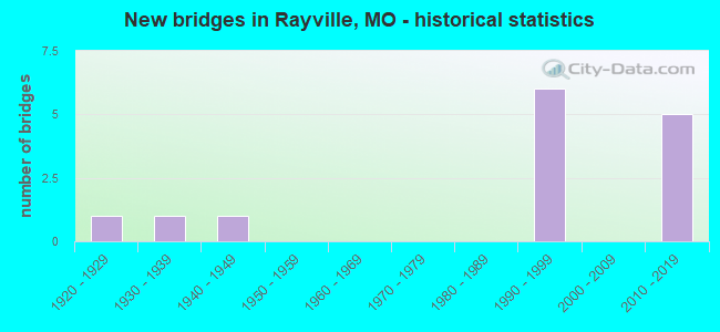
- New bridges - historical statistics
- 11920-1929
- 11930-1939
- 11940-1949
- 61990-1999
- 52010-2019

- Reconstructed bridges - Historical Statistics
- 11950-1959
- 01960-1969
- 01970-1979
- 11980-1989


- Bridge Condition - Deck
- 9.1%Excellent
- 18.2%Very good
- 45.5%Good
- 9.1%Satisfactory
- 18.2%Poor

- Bridge Condition - Superstructure
- 9.1%Excellent
- 36.4%Very good
- 18.2%Good
- 18.2%Satisfactory
- 18.2%Fair

- Bridge Condition - Substructure
- 9.1%Excellent
- 27.3%Very good
- 27.3%Good
- 9.1%Satisfactory
- 27.3%Fair

- Bridge Condition - Channel
- 40.0%Very good
- 10.0%Good
- 10.0%Satisfactory
- 40.0%Fair
Find on map >> Show street view
Structure Number: 17828, Location: S 26 T 53 N R 28 W (Lat: 39.379556, Lng: -94.010800), Route carried "on" structure: County highway 164, Year Built: 1940, Status: Posted for load, Structure Length: 0.91m (2.99ft), Average Daily Traffic: 55 (year 2021), Truck Traffic: 10%, Average Future Daily Traffic: 74 (year 2041), Features Intersected: BR OF CROOKED RVR, Facility Carried by Structure: W 160 ST
Minimum Vertical Clearance: 30+ m (98+ ft), Kilometerpoint: 1.448, Lanes on structure: 1, Owner: County Highway Agency, Approaching Roadway Width: 5.5m (18.0ft), Material/Design: Steel, Design/Construction: Stringer/Multi-beam, Number Of Spans In Main Unit: 1, Length of Maximum Span: 8.8m (28.9ft), Curb-To-Curb Width: 4.5m (14.8ft), Out-to-Out Width: 4.8m (15.7ft)
Condition: Deck: Poor, Superstructure: Fair, Substructure: Fair, Channel: Fair, Operating Rating: 20.7 metric tons, Method Used To Determine Operating Rating: Allowable Stress (AS), Inventory Rating: 16.2 metric tons, Method Used To Determine Inventory Rating: Allowable Stress (AS), Structural Evaluation: Somewhat better than minimum adequacy, Deck Geometry: Equal to present minimum criteria, Waterway Adequacy: Better than present minimum criteria, Approach Roadway Alignment: Equal to present desirable criteria, Bridge Posting: Required (Relationship of Operating Rating to Maximum Legal Load: 10.0 - 19.9% below), Length Of Structure Improvement: 0.16m (0.52ft), Designated Inspection Frequency: Every 24 months, Inspection Date: May 2021, Bridge Improvement Cost: $115,000, Roadway Improvement Cost: $12,000, Total Project Cost: $173,000 ( Estimate for 2022), Deck Structure Type: Concrete Cast-file-Place, Wearing Surface/Protective System: Wearing Surface: Monolithic Concrete
Find on map >> Show street view
Structure Number: 17916, Location: S 29 T 53 N R 28 W (Lat: 39.373617, Lng: -94.059992), Route carried "on" structure: County highway 167, Year Built: 1930, Year Reconstructed: 1992, Status: Posted for load, Structure Length: 1.49m (4.89ft), Average Daily Traffic: 220 (year 2021), Truck Traffic: 10%, Average Future Daily Traffic: 297 (year 2041), Features Intersected: ROCKY FK OF CROOKE, Facility Carried by Structure: W 156 ST
Minimum Vertical Clearance: 30+ m (98+ ft), Kilometerpoint: 0.805, Lanes on structure: 1, Owner: County Highway Agency, Approaching Roadway Width: 7.3m (24.0ft), Material/Design: Steel, Design/Construction: Stringer/Multi-beam, Number Of Spans In Main Unit: 1, Length of Maximum Span: 14.3m (46.9ft), Curb-To-Curb Width: 4.8m (15.7ft), Out-to-Out Width: 5.0m (16.4ft)
Condition: Deck: Good, Superstructure: Satisfactory, Substructure: Fair, Channel: Fair, Operating Rating: 89.1 metric tons, Method Used To Determine Operating Rating: Allowable Stress (AS), Inventory Rating: 53.1 metric tons, Method Used To Determine Inventory Rating: Allowable Stress (AS), Structural Evaluation: Somewhat better than minimum adequacy, Deck Geometry: High priority of corrective action, Waterway Adequacy: Equal to present minimum criteria, Approach Roadway Alignment: Equal to present desirable criteria, Length Of Structure Improvement: 0.22m (0.72ft), Designated Inspection Frequency: Every 24 months, Inspection Date: May 2021, Bridge Improvement Cost: $109,000, Roadway Improvement Cost: $11,000, Total Project Cost: $163,000 ( Estimate for 2022), Deck Structure Type: Concrete Cast-file-Place, Wearing Surface/Protective System: Wearing Surface: Monolithic Concrete
Find on map >> Show street view
Structure Number: 17932, Location: S 28 T 53 N R 28 W (Lat: 39.372936, Lng: -94.043250), Route carried "on" structure: County highway 167, Year Built: 1999, Status: Open, Structure Length: 7.44m (24.41ft), Average Daily Traffic: 109 (year 2021), Truck Traffic: 10%, Average Future Daily Traffic: 147 (year 2041), Design Load: HS 20, Features Intersected: CROOKED RVR, Facility Carried by Structure: W 156 ST
Minimum Vertical Clearance: 3.96m (12.99ft), Kilometerpoint: 2.253, Lanes on structure: 2, Owner: County Highway Agency, Approaching Roadway Width: 7.3m (24.0ft), Skew: 4 degrees, Material/Design: Prestressed concrete, Design/Construction: Stringer/Multi-beam, Number Of Spans In Main Unit: 3, Length of Maximum Span: 27.4m (89.9ft), Curb-To-Curb Width: 7.3m (24.0ft), Out-to-Out Width: 7.5m (24.6ft)
Condition: Deck: Very good, Superstructure: Very good, Substructure: Very good, Channel: Satisfactory, Operating Rating: 78.3 metric tons, Method Used To Determine Operating Rating: Load Factor (LF), Inventory Rating: 46.8 metric tons, Method Used To Determine Inventory Rating: Load Factor (LF), Structural Evaluation: Equal to present desirable criteria, Deck Geometry: High priority of corrective action, Waterway Adequacy: Equal to present desirable criteria, Approach Roadway Alignment: Equal to present desirable criteria, Designated Inspection Frequency: Every 24 months, Inspection Date: May 2021, Deck Structure Type: Concrete Cast-file-Place
Find on map >> Show street view
Structure Number: 17958, Location: S 28 T 53 N R 28 W (Lat: 39.368833, Lng: -94.041728), Route carried "on" structure: County highway 168, Year Built: 1993, Status: Open, Structure Length: 5.58m (18.31ft), Average Daily Traffic: 45 (year 2021), Truck Traffic: 10%, Average Future Daily Traffic: 61 (year 2041), Design Load: HS 20, Features Intersected: CROOKED CR, Facility Carried by Structure: HARTMAN RD
Minimum Vertical Clearance: 30+ m (98+ ft), Kilometerpoint: 0.322, Lanes on structure: 2, Owner: County Highway Agency, Approaching Roadway Width: 7.6m (24.9ft), Skew: 4 degrees, Material/Design: Prestressed concrete, Design/Construction: Stringer/Multi-beam, Number Of Spans In Main Unit: 3, Length of Maximum Span: 18.3m (60.0ft), Curb-To-Curb Width: 7.3m (24.0ft), Out-to-Out Width: 8.1m (26.6ft)
Condition: Deck: Good, Superstructure: Very good, Substructure: Good, Channel: Fair, Operating Rating: 85.5 metric tons, Method Used To Determine Operating Rating: Allowable Stress (AS), Inventory Rating: 40.5 metric tons, Method Used To Determine Inventory Rating: Allowable Stress (AS), Structural Evaluation: Better than present minimum criteria, Deck Geometry: Equal to present minimum criteria, Waterway Adequacy: Equal to present minimum criteria, Approach Roadway Alignment: Equal to present desirable criteria, Designated Inspection Frequency: Every 24 months, Inspection Date: May 2021, Deck Structure Type: Concrete Cast-file-Place, Wearing Surface/Protective System: Wearing Surface: Monolithic Concrete
Find on map >> Show street view
Structure Number: 2644, Location: S 32 T 52 N R 27 W (Lat: 39.267308, Lng: -93.963403), Route carried "on" structure: State highway 10, Year Built: 1994, Status: Open, Structure Length: 5.21m (17.09ft), Average Daily Traffic: 6,929 (year 2021), Truck Traffic: 8%, Average Future Daily Traffic: 10,740 (year 2041), Design Load: HS 20+Mod, Features Intersected: MO 13
Minimum Vertical Clearance: 30+ m (98+ ft), Kilometerpoint: 30.682, Lanes on structure: 2, Lanes under structure: 5, Base Highway Network: Yes, Owner: State Highway Agency, Approaching Roadway Width: 13.4m (44.0ft), Skew: 1 degrees, Material/Design: Prestressed concrete continuous, Design/Construction: Stringer/Multi-beam, Number Of Spans In Main Unit: 3, Length of Maximum Span: 25.9m (85.0ft), Curb or Sidewalk Widths: Left: 0.2m (0.7ft), Right: 0.2m (0.7ft), Curb-To-Curb Width: 13.4m (44.0ft), Out-to-Out Width: 14.3m (46.9ft)
Condition: Deck: Very good, Superstructure: Very good, Substructure: Very good, Inventory Rating: 61.2 metric tons, Method Used To Determine Inventory Rating: Load Factor (LF), Structural Evaluation: Equal to present desirable criteria, Deck Geometry: Equal to present minimum criteria, Underclear: Equal to present minimum criteria, Approach Roadway Alignment: Better than present minimum criteria, Designated Inspection Frequency: Every 24 months, Inspection Date: November 2020, Deck Structure Type: Concrete Cast-file-Place, Wearing Surface/Protective System: Wearing Surface: Monolithic Concrete, Deck Protection: Epoxy Coated Reinforcing
Find on map >> Show street view
Structure Number: 2645, Location: S 32 T 52 N R 27 W (Lat: 39.269169, Lng: -93.959086), Route carried "on" structure: Business State highway 13, Year Built: 1994, Status: Open, Structure Length: 8.87m (29.10ft), Average Daily Traffic: 3,040 (year 2021), Truck Traffic: 2%, Average Future Daily Traffic: 4,712 (year 2041), Design Load: HS 20, Features Intersected: MO 10
Minimum Vertical Clearance: 30+ m (98+ ft), Kilometerpoint: 1.984, Lanes on structure: 2, Lanes under structure: 4, Owner: State Highway Agency, Approaching Roadway Width: 12.2m (40.0ft), Material/Design: Steel continuous, Design/Construction: Stringer/Multi-beam, Number Of Spans In Main Unit: 2, Length of Maximum Span: 36.8m (120.7ft), Curb or Sidewalk Widths: Left: 0.2m (0.7ft), Right: 0.2m (0.7ft), Curb-To-Curb Width: 12.2m (40.0ft), Out-to-Out Width: 13.0m (42.7ft)
Condition: Deck: Good, Superstructure: Very good, Substructure: Good, Operating Rating: 61.2 metric tons, Method Used To Determine Operating Rating: Load Factor (LF), Inventory Rating: 36.9 metric tons, Method Used To Determine Inventory Rating: Load Factor (LF), Structural Evaluation: Better than present minimum criteria, Deck Geometry: Equal to present minimum criteria, Underclear: Equal to present desirable criteria, Approach Roadway Alignment: Equal to present desirable criteria, Designated Inspection Frequency: Every 24 months, Inspection Date: November 2020, Deck Structure Type: Concrete Cast-file-Place, Wearing Surface/Protective System: Wearing Surface: Monolithic Concrete, Deck Protection: Epoxy Coated Reinforcing
Find on map >> Show street view
Structure Number: 33503, Location: S 29 T 53 N R 28 W (Lat: 39.374983, Lng: -94.071650), Route carried "on" structure: State highway C, Year Built: 2011, Status: Open, Structure Length: 5.03m (16.50ft), Average Daily Traffic: 805 (year 2021), Truck Traffic: 2%, Average Future Daily Traffic: 1,167 (year 2041), Design Load: HS 20, Features Intersected: ROCKY FK CR
Minimum Vertical Clearance: 30+ m (98+ ft), Kilometerpoint: 19.750, Lanes on structure: 2, Owner: State Highway Agency, Approaching Roadway Width: 8.5m (27.9ft), Skew: 4 degrees, Material/Design: Prestressed concrete, Design/Construction: Box Beam or Girders - Single/Spread, Number Of Spans In Main Unit: 1, Number Of Approach Spans: 2, Length of Maximum Span: 19.8m (65.0ft), Curb-To-Curb Width: 8.5m (27.9ft), Out-to-Out Width: 9.1m (29.9ft)
Condition: Deck: Good, Superstructure: Good, Substructure: Very good, Channel: Very good, Operating Rating: 87.3 metric tons, Method Used To Determine Operating Rating: Load Factor (LF), Inventory Rating: 47.7 metric tons, Method Used To Determine Inventory Rating: Load Factor (LF), Structural Evaluation: Better than present minimum criteria, Deck Geometry: Somewhat better than minimum adequacy, Waterway Adequacy: Superior to present desirable criteria, Approach Roadway Alignment: Equal to present desirable criteria, Designated Inspection Frequency: Every 24 months, Inspection Date: November 2020, Deck Structure Type: Concrete Cast-file-Place, Wearing Surface/Protective System: Wearing Surface: Monolithic Concrete, Deck Protection: Epoxy Coated Reinforcing
Find on map >> Show street view
Structure Number: 33629, Location: S 35 T 53 N R 28 W (Lat: 39.364936, Lng: -94.008083), Route carried "on" structure: State highway FF, Year Built: 2011, Status: Open, Structure Length: 2.90m (9.51ft), Average Daily Traffic: 157 (year 2021), Truck Traffic: 14%, Average Future Daily Traffic: 228 (year 2041), Design Load: HS 20, Features Intersected: MCDONALD BR
Minimum Vertical Clearance: 30+ m (98+ ft), Kilometerpoint: 3.454, Lanes on structure: 2, Owner: State Highway Agency, Approaching Roadway Width: 7.3m (24.0ft), Material/Design: Prestressed concrete, Design/Construction: Box Beam or Girders - Multiple, Number Of Spans In Main Unit: 2, Length of Maximum Span: 18.3m (60.0ft), Curb-To-Curb Width: 7.3m (24.0ft), Out-to-Out Width: 7.9m (25.9ft)
Condition: Deck: Excellent, Superstructure: Excellent, Substructure: Satisfactory, Channel: Very good, Operating Rating: 66.6 metric tons, Method Used To Determine Operating Rating: Load Factor (LF), Inventory Rating: 38.7 metric tons, Method Used To Determine Inventory Rating: Load Factor (LF), Structural Evaluation: Equal to present minimum criteria, Deck Geometry: Somewhat better than minimum adequacy, Waterway Adequacy: Superior to present desirable criteria, Approach Roadway Alignment: Equal to present desirable criteria, Designated Inspection Frequency: Every 24 months, Inspection Date: November 2020, Deck Structure Type: Concrete Precast Panels, Wearing Surface/Protective System: Wearing Surface: Bituminous, Deck Protection: Epoxy Coated Reinforcing
Find on map >> Show street view
Structure Number: 33635, Location: S 29 T 53 N R 28 W (Lat: 39.370711, Lng: -94.065758), Route carried "on" structure: State highway C, Year Built: 2011, Status: Open, Structure Length: 2.74m (8.99ft), Average Daily Traffic: 805 (year 2021), Truck Traffic: 4%, Average Future Daily Traffic: 1,167 (year 2041), Design Load: HS 20, Features Intersected: SWAFFORD BR
Minimum Vertical Clearance: 30+ m (98+ ft), Kilometerpoint: 10.590, Lanes on structure: 2, Owner: State Highway Agency, Approaching Roadway Width: 7.6m (24.9ft), Skew: 3 degrees, Material/Design: Prestressed concrete, Design/Construction: Box Beam or Girders - Multiple, Number Of Spans In Main Unit: 1, Length of Maximum Span: 27.4m (89.9ft), Curb-To-Curb Width: 7.6m (24.9ft), Out-to-Out Width: 8.2m (26.9ft)
Condition: Deck: Satisfactory, Superstructure: Satisfactory, Substructure: Excellent, Channel: Very good, Operating Rating: 66.6 metric tons, Method Used To Determine Operating Rating: Load Factor (LF), Inventory Rating: 32.4 metric tons, Method Used To Determine Inventory Rating: Load Factor (LF), Structural Evaluation: Equal to present minimum criteria, Deck Geometry: Meets minimum limits, Waterway Adequacy: Superior to present desirable criteria, Approach Roadway Alignment: Equal to present desirable criteria, Designated Inspection Frequency: Every 24 months, Inspection Date: November 2020, Deck Structure Type: Concrete Precast Panels, Wearing Surface/Protective System: Wearing Surface: Bituminous, Deck Protection: Epoxy Coated Reinforcing
Find on map >> Show street view
Structure Number: 33641, Location: S 21 T 52 N R 28 W (Lat: 39.292608, Lng: -94.048967), Route carried "on" structure: State highway 10, Year Built: 2011, Status: Open, Structure Length: 3.55m (11.65ft), Average Daily Traffic: 3,479 (year 2021), Truck Traffic: 6%, Average Future Daily Traffic: 6,088 (year 2041), Design Load: HS 20, Features Intersected: CROOKED RVR
Minimum Vertical Clearance: 30+ m (98+ ft), Kilometerpoint: 21.367, Lanes on structure: 2, Base Highway Network: Yes, Owner: State Highway Agency, Approaching Roadway Width: 10.4m (34.1ft), Material/Design: Prestressed concrete, Design/Construction: Box Beam or Girders - Multiple, Number Of Spans In Main Unit: 1, Length of Maximum Span: 35.1m (115.2ft), Curb-To-Curb Width: 10.4m (34.1ft), Out-to-Out Width: 11.0m (36.1ft)
Condition: Deck: Good, Superstructure: Good, Substructure: Good, Channel: Very good, Operating Rating: 93.6 metric tons, Method Used To Determine Operating Rating: Load Factor (LF), Inventory Rating: 43.2 metric tons, Method Used To Determine Inventory Rating: Load Factor (LF), Structural Evaluation: Better than present minimum criteria, Deck Geometry: Somewhat better than minimum adequacy, Waterway Adequacy: Superior to present desirable criteria, Approach Roadway Alignment: Equal to present desirable criteria, Designated Inspection Frequency: Every 24 months, Inspection Date: November 2020, Deck Structure Type: Concrete Cast-file-Place, Wearing Surface/Protective System: Wearing Surface: Monolithic Concrete, Deck Protection: Epoxy Coated Reinforcing
Find on map >> Show street view
Structure Number: 36045, Location: S 16 T 52 N R 28 W (Lat: 39.311042, Lng: -94.054711), Route carried "on" structure: County highway 220, Year Built: 2019, Status: Open, Structure Length: 0.78m (2.56ft), Average Daily Traffic: 30 (year 2021), Truck Traffic: 10%, Average Future Daily Traffic: 41 (year 2041), Design Load: HS 20, Features Intersected: W FORK CROOKED RVR, Facility Carried by Structure: W 122ST
Minimum Vertical Clearance: 30+ m (98+ ft), Kilometerpoint: 0.322, Lanes on structure: 2, Owner: County Highway Agency, Approaching Roadway Width: 7.3m (24.0ft), Skew: 2 degrees, Material/Design: Concrete, Design/Construction: Culvert, Number Of Spans In Main Unit: 1, Length of Maximum Span: 7.3m (24.0ft), Curb-To-Curb Width: 7.3m (24.0ft), Out-to-Out Width: 14.7m (48.2ft)
Condition: Channel: Good, Culverts: Good, Operating Rating: 81.0 metric tons, Method Used To Determine Operating Rating: Load Factor (LF), Inventory Rating: 48.6 metric tons, Method Used To Determine Inventory Rating: Load Factor (LF), Structural Evaluation: Better than present minimum criteria, Deck Geometry: Equal to present minimum criteria, Waterway Adequacy: Superior to present desirable criteria, Approach Roadway Alignment: Equal to present desirable criteria, Designated Inspection Frequency: Every 24 months, Inspection Date: May 2021, Deck Structure Type: Concrete Cast-file-Place, Wearing Surface/Protective System: Wearing Surface: Other
Find on map >> Show street view
Structure Number: 4799, Location: S 20 T 52 N R 28 W (Lat: 39.304497, Lng: -94.075231), Route carried "on" structure: State highway 10, Year Built: 1924, Year Reconstructed: 1962, Status: Open, Structure Length: 3.05m (10.01ft), Average Daily Traffic: 3,479 (year 2021), Truck Traffic: 6%, Average Future Daily Traffic: 6,088 (year 2041), Design Load: H 20, Features Intersected: CROOKED RVR
Minimum Vertical Clearance: 30+ m (98+ ft), Kilometerpoint: 18.648, Lanes on structure: 2, Base Highway Network: Yes, Owner: State Highway Agency, Approaching Roadway Width: 7.3m (24.0ft), Material/Design: Concrete, Design/Construction: Tee Beam, Number Of Spans In Main Unit: 1, Number Of Approach Spans: 2, Length of Maximum Span: 9.8m (32.2ft), Curb-To-Curb Width: 8.5m (27.9ft), Out-to-Out Width: 9.6m (31.5ft)
Condition: Deck: Poor, Superstructure: Fair, Substructure: Fair, Channel: Fair, Operating Rating: 60.3 metric tons, Method Used To Determine Operating Rating: Load Factor (LF), Inventory Rating: 36.0 metric tons, Method Used To Determine Inventory Rating: Load Factor (LF), Structural Evaluation: Somewhat better than minimum adequacy, Deck Geometry: Meets minimum limits, Waterway Adequacy: Equal to present minimum criteria, Approach Roadway Alignment: Equal to present minimum criteria, Length Of Structure Improvement: 0.39m (1.28ft), Designated Inspection Frequency: Every 24 months, Inspection Date: November 2020, Bridge Improvement Cost: $366,000, Roadway Improvement Cost: $37,000, Total Project Cost: $548,000 ( Estimate for 2022), Deck Structure Type: Concrete Cast-file-Place, Wearing Surface/Protective System: Wearing Surface: Bituminous
Find on map >> Show street view
Structure Number: 2644, Location: S 32 T 52 N R 27 W (Lat: 39.267308, Lng: -93.963403), Route carried "under" structure: State highway 13, Year Built: 1994, Structure Length: 0. m, Average Daily Traffic: 10,539 (year 2021), Truck Traffic: 12%, Features Intersected: MO 13, Facility Carried by Structure: MO 10 E
Minimum Vertical Clearance: 5.46m (17.91ft), Kilometerpoint: 118.693, Lanes on structure: 2, Lanes under structure: 5, Material/Design: Prestressed concrete continuous, Design/Construction: Stringer/Multi-beam, Length of Maximum Span: 25.9m (85.0ft)
Find on map >> Show street view
Structure Number: 2645, Location: S 32 T 52 N R 27 W (Lat: 39.269169, Lng: -93.959086), Route carried "under" structure: State highway 10, Year Built: 1994, Structure Length: 0. m, Average Daily Traffic: 4,771 (year 2021), Truck Traffic: 10%, Features Intersected: MO 10, Facility Carried by Structure: BU 13 S
Minimum Vertical Clearance: 5.05m (16.57ft), Kilometerpoint: 31.146, Lanes on structure: 2, Lanes under structure: 4, Material/Design: Steel continuous, Design/Construction: Stringer/Multi-beam, Length of Maximum Span: 36.8m (120.7ft)