Bridge Statistics for Red Jacket, West Virginia (WV)
Condition, Traffic, Stress, Structural Evaluation, Project Costs
- National Bridge Inventory (NBI) Statistics
- 21Number of bridges
- 79ft / 23.8mTotal length
- $677,000Total costs
- 19,830Total average daily traffic
- 1,685Total average daily truck traffic
- National Bridge Inventory (NBI) Registered Bridges for Red Jacket
- No street view available for this location
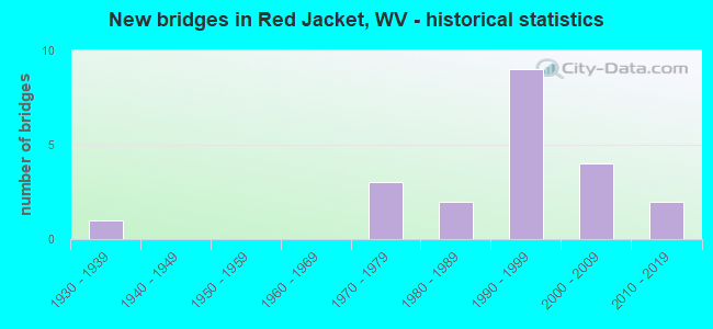
- New bridges - historical statistics
- 11930-1939
- 31970-1979
- 21980-1989
- 91990-1999
- 42000-2009
- 22010-2019


- Bridge Condition - Deck
- 6.3%Good
- 81.3%Satisfactory
- 12.5%Fair

- Bridge Condition - Superstructure
- 25.0%Good
- 62.5%Satisfactory
- 12.5%Fair

- Bridge Condition - Substructure
- 43.8%Good
- 25.0%Satisfactory
- 25.0%Fair
- 6.3%Poor

- Bridge Condition - Channel
- 62.5%Good
- 18.8%Satisfactory
- 6.3%Fair
- 12.5%Poor
Find on map >> Show street view
Structure Number: 30A036, Location: 0.01 MI WEST OF CR 6/5 (Lat: 37.636631, Lng: -82.098600), Route carried "on" structure: County highway 600, Year Built: 1995, Status: Open, Structure Length: 1.26m (4.13ft), Average Daily Traffic: 1,200 (year 2019), Truck Traffic: 6%, Average Future Daily Traffic: 1,500 (year 2039), Features Intersected: MATE CREEK, Facility Carried by Structure: CR 6
Minimum Vertical Clearance: 30+ m (98+ ft), Kilometerpoint: 4.635, Lanes on structure: 2, Owner: State Highway Agency, Approaching Roadway Width: 7.0m (23.0ft), Skew: 3 degrees, Material/Design: Prestressed concrete, Design/Construction: Box Beam or Girders - Multiple, Number Of Spans In Main Unit: 1, Length of Maximum Span: 12.2m (40.0ft), Curb-To-Curb Width: 7.1m (23.3ft), Out-to-Out Width: 7.4m (24.3ft)
Condition: Deck: Satisfactory, Superstructure: Satisfactory, Substructure: Satisfactory, Channel: Good, Operating Rating: 88.9 metric tons, Method Used To Determine Operating Rating: Load Factor (LF), Inventory Rating: 59.9 metric tons, Method Used To Determine Inventory Rating: Load Factor (LF), Structural Evaluation: Equal to present minimum criteria, Deck Geometry: High priority of corrective action, Waterway Adequacy: Equal to present minimum criteria, Approach Roadway Alignment: Equal to present desirable criteria, Length Of Structure Improvement: 1.25m (4.10ft), Designated Inspection Frequency: Every 24 months, Inspection Date: January 2021, Bridge Improvement Cost: $50,000, Roadway Improvement Cost: $15,000, Total Project Cost: $65,000 ( Estimate for 2017), Deck Structure Type: Other, Wearing Surface/Protective System: Wearing Surface: Monolithic Concrete, Deck Protection: Epoxy Coated Reinforcing
Find on map >> Show street view
Structure Number: 30A079, Location: 0.01 MI SOUTH OF US 52 (Lat: 37.668761, Lng: -82.127011), Route carried "on" structure: County highway 5224, Year Built: 1997, Status: Open, Structure Length: 1.27m (4.17ft), Average Daily Traffic: 150 (year 2019), Truck Traffic: 6%, Average Future Daily Traffic: 190 (year 2039), Features Intersected: PIGEON CREEK, Facility Carried by Structure: CR 52/24
Minimum Vertical Clearance: 30+ m (98+ ft), Kilometerpoint: 0.016, Lanes on structure: 1, Owner: State Highway Agency, Approaching Roadway Width: 2.7m (8.9ft), Material/Design: Prestressed concrete, Design/Construction: Box Beam or Girders - Multiple, Number Of Spans In Main Unit: 1, Length of Maximum Span: 12.2m (40.0ft), Curb or Sidewalk Widths: Left: 0.2m (0.7ft), Right: 0.2m (0.7ft), Curb-To-Curb Width: 4.1m (13.5ft), Out-to-Out Width: 4.6m (15.1ft)
Condition: Deck: Satisfactory, Superstructure: Satisfactory, Substructure: Satisfactory, Channel: Good, Operating Rating: 88.9 metric tons, Method Used To Determine Operating Rating: Field evaluation and documented engineering judgment, Inventory Rating: 40.8 metric tons, Method Used To Determine Inventory Rating: Field evaluation and documented engineering judgment, Structural Evaluation: Equal to present minimum criteria, Deck Geometry: High priority of replacement, Waterway Adequacy: Better than present minimum criteria, Approach Roadway Alignment: Somewhat better than minimum adequacy, Length Of Structure Improvement: 1.28m (4.20ft), Designated Inspection Frequency: Every 24 months, Inspection Date: March 2021, Bridge Improvement Cost: $118,000, Roadway Improvement Cost: $24,000, Total Project Cost: $142,000 ( Estimate for 2017), Deck Structure Type: Other, Wearing Surface/Protective System: Wearing Surface: Monolithic Concrete, Deck Protection: Epoxy Coated Reinforcing
Find on map >> Show street view
Structure Number: 30A08, Location: 0.01 MI SOUTH OF US 52 (Lat: 37.669400, Lng: -82.111311), Route carried "on" structure: County highway 5225, Year Built: 1994, Status: Open, Structure Length: 1.33m (4.36ft), Average Daily Traffic: 20 (year 2019), Average Future Daily Traffic: 22 (year 2039), Design Load: HS 25 or greater, Features Intersected: PIGEON CREEK, Facility Carried by Structure: CR 52/25
Minimum Vertical Clearance: 30+ m (98+ ft), Kilometerpoint: 0.016, Lanes on structure: 2, Owner: State Highway Agency, Approaching Roadway Width: 3.4m (11.2ft), Material/Design: Prestressed concrete, Design/Construction: Box Beam or Girders - Multiple, Number Of Spans In Main Unit: 1, Length of Maximum Span: 12.8m (42.0ft), Curb-To-Curb Width: 7.1m (23.3ft), Out-to-Out Width: 7.5m (24.6ft)
Condition: Deck: Satisfactory, Superstructure: Satisfactory, Substructure: Satisfactory, Channel: Good, Operating Rating: 88.9 metric tons, Method Used To Determine Operating Rating: Load Factor (LF), Inventory Rating: 54.4 metric tons, Method Used To Determine Inventory Rating: Load Factor (LF), Structural Evaluation: Equal to present minimum criteria, Deck Geometry: Somewhat better than minimum adequacy, Waterway Adequacy: Better than present minimum criteria, Approach Roadway Alignment: Equal to present minimum criteria, Designated Inspection Frequency: Every 24 months, Inspection Date: May 2021, Deck Structure Type: Other, Wearing Surface/Protective System: Wearing Surface: Bituminous, Deck Protection: Epoxy Coated Reinforcing
Find on map >> Show street view
Structure Number: 30A081, Location: 0.01 MI SOUTH OF US 52 (Lat: 37.652550, Lng: -82.061719), Route carried "on" structure: County highway 5226, Year Built: 1986, Status: Open, Structure Length: 1.02m (3.35ft), Average Daily Traffic: 100 (year 2018), Truck Traffic: 6%, Average Future Daily Traffic: 125 (year 2038), Design Load: HS 20, Features Intersected: PIGEON CREEK, Facility Carried by Structure: CR 52/26
Minimum Vertical Clearance: 30+ m (98+ ft), Kilometerpoint: 0.016, Lanes on structure: 2, Owner: State Highway Agency, Approaching Roadway Width: 7.9m (25.9ft), Material/Design: Prestressed concrete, Design/Construction: Box Beam or Girders - Multiple, Number Of Spans In Main Unit: 1, Length of Maximum Span: 9.8m (32.2ft), Curb-To-Curb Width: 7.0m (23.0ft), Out-to-Out Width: 7.3m (24.0ft)
Condition: Deck: Satisfactory, Superstructure: Satisfactory, Substructure: Fair, Channel: Good, Operating Rating: 88.9 metric tons, Method Used To Determine Operating Rating: Load Factor (LF), Inventory Rating: 59.9 metric tons, Method Used To Determine Inventory Rating: Load Factor (LF), Structural Evaluation: Somewhat better than minimum adequacy, Deck Geometry: Somewhat better than minimum adequacy, Waterway Adequacy: Equal to present minimum criteria, Approach Roadway Alignment: Somewhat better than minimum adequacy, Designated Inspection Frequency: Every 24 months, Inspection Date: July 2020, Deck Structure Type: Other, Wearing Surface/Protective System: Wearing Surface: Bituminous
Find on map >> Show street view
Structure Number: 30A091, Location: 0.01 MI. WEST OF CO 65/84 (Lat: 37.693489, Lng: -82.076269), Route carried "on" structure: County highway 6505, Year Built: 1991, Year Reconstructed: 1998, Status: Open, Structure Length: 1.20m (3.94ft), Average Daily Traffic: 300 (year 2019), Truck Traffic: 6%, Average Future Daily Traffic: 492 (year 2036), Design Load: HS 25 or greater, Features Intersected: ROCKHOUSE FORK, Facility Carried by Structure: CR 65/5
Minimum Vertical Clearance: 30+ m (98+ ft), Kilometerpoint: 11.459, Lanes on structure: 2, Owner: State Highway Agency, Approaching Roadway Width: 7.3m (24.0ft), Material/Design: Prestressed concrete, Design/Construction: Box Beam or Girders - Multiple, Number Of Spans In Main Unit: 1, Length of Maximum Span: 11.6m (38.1ft), Curb-To-Curb Width: 7.0m (23.0ft), Out-to-Out Width: 7.3m (24.0ft)
Condition: Deck: Satisfactory, Superstructure: Satisfactory, Substructure: Good, Channel: Good, Operating Rating: 72.6 metric tons, Method Used To Determine Operating Rating: Load Factor (LF), Inventory Rating: 43.5 metric tons, Method Used To Determine Inventory Rating: Load Factor (LF), Structural Evaluation: Equal to present minimum criteria, Deck Geometry: Meets minimum limits, Waterway Adequacy: Equal to present minimum criteria, Approach Roadway Alignment: Equal to present desirable criteria, Length Of Structure Improvement: 1.22m (4.00ft), Designated Inspection Frequency: Every 24 months, Inspection Date: April 2020, Bridge Improvement Cost: $40,000, Roadway Improvement Cost: $1,000, Total Project Cost: $45,000 ( Estimate for 2018), Deck Structure Type: Concrete Cast-file-Place
Find on map >> Show street view
Structure Number: 30A114, Location: 0.17 MI SOUTH OF US 52 (Lat: 37.656100, Lng: -82.094581), Route carried "on" structure: County highway 5249, Year Built: 1992, Status: Open, Structure Length: 1.33m (4.36ft), Average Daily Traffic: 60 (year 2018), Truck Traffic: 6%, Average Future Daily Traffic: 75 (year 2038), Design Load: HS 25 or greater, Features Intersected: PIGEON CREEK, Facility Carried by Structure: CR 52/49
Minimum Vertical Clearance: 30+ m (98+ ft), Kilometerpoint: 0.274, Lanes on structure: 2, Owner: State Highway Agency, Approaching Roadway Width: 4.9m (16.1ft), Skew: 1 degrees, Material/Design: Prestressed concrete, Design/Construction: Box Beam or Girders - Multiple, Number Of Spans In Main Unit: 1, Length of Maximum Span: 12.8m (42.0ft), Curb-To-Curb Width: 6.1m (20.0ft), Out-to-Out Width: 6.4m (21.0ft)
Condition: Deck: Satisfactory, Superstructure: Satisfactory, Substructure: Poor, Channel: Poor, Operating Rating: 88.9 metric tons, Method Used To Determine Operating Rating: Load Factor (LF), Inventory Rating: 58.0 metric tons, Method Used To Determine Inventory Rating: Load Factor (LF), Structural Evaluation: Meets minimum limits, Deck Geometry: Somewhat better than minimum adequacy, Waterway Adequacy: Somewhat better than minimum adequacy, Approach Roadway Alignment: Somewhat better than minimum adequacy, Designated Inspection Frequency: Every 24 months, Underwater Inspection Frequency: Every 60 months, Inspection Date: April 2020, Underwater Inspection Date: June 2017, Deck Structure Type: Other, Wearing Surface/Protective System: Wearing Surface: Latex Concrete
Find on map >> Show street view
Structure Number: 30A143, Location: 0.01 MI EAST OF US 52 (Lat: 37.652281, Lng: -82.045400), Route carried "on" structure: County highway 5238, Year Built: 1980, Status: Open, Structure Length: 1.02m (3.35ft), Average Daily Traffic: 150 (year 2018), Truck Traffic: 6%, Average Future Daily Traffic: 188 (year 2038), Features Intersected: PIGEON CREEK, Facility Carried by Structure: CR 52/38
Minimum Vertical Clearance: 30+ m (98+ ft), Kilometerpoint: 0.016, Lanes on structure: 2, Owner: State Highway Agency, Approaching Roadway Width: 6.7m (22.0ft), Material/Design: Prestressed concrete, Design/Construction: Box Beam or Girders - Multiple, Number Of Spans In Main Unit: 1, Length of Maximum Span: 9.8m (32.2ft), Curb-To-Curb Width: 7.3m (24.0ft), Out-to-Out Width: 7.3m (24.0ft)
Condition: Deck: Satisfactory, Superstructure: Satisfactory, Substructure: Fair, Channel: Satisfactory, Operating Rating: 71.7 metric tons, Method Used To Determine Operating Rating: Field evaluation and documented engineering judgment, Inventory Rating: 32.7 metric tons, Method Used To Determine Inventory Rating: Field evaluation and documented engineering judgment, Structural Evaluation: Somewhat better than minimum adequacy, Deck Geometry: Somewhat better than minimum adequacy, Waterway Adequacy: Equal to present minimum criteria, Approach Roadway Alignment: Equal to present minimum criteria, Designated Inspection Frequency: Every 24 months, Inspection Date: March 2020, Deck Structure Type: Other, Wearing Surface/Protective System: Wearing Surface: Bituminous
Find on map >> Show street view
Structure Number: 30A154, Location: 0.01 MI NORTH OF CR 6 (Lat: 37.624869, Lng: -82.075311), Route carried "on" structure: County highway 607, Year Built: 1990, Status: Open, Structure Length: 1.51m (4.95ft), Average Daily Traffic: 70 (year 2019), Truck Traffic: 7%, Average Future Daily Traffic: 75 (year 2039), Design Load: HS 20, Features Intersected: MATE CREEK, Facility Carried by Structure: CR 6/7
Minimum Vertical Clearance: 30+ m (98+ ft), Kilometerpoint: 0.016, Lanes on structure: 2, Owner: State Highway Agency, Approaching Roadway Width: 5.5m (18.0ft), Material/Design: Prestressed concrete, Design/Construction: Box Beam or Girders - Multiple, Number Of Spans In Main Unit: 1, Length of Maximum Span: 14.6m (47.9ft), Curb-To-Curb Width: 7.0m (23.0ft), Out-to-Out Width: 7.3m (24.0ft)
Condition: Deck: Fair, Superstructure: Fair, Substructure: Fair, Channel: Fair, Operating Rating: 88.9 metric tons, Method Used To Determine Operating Rating: Load Factor (LF), Inventory Rating: 58.0 metric tons, Method Used To Determine Inventory Rating: Load Factor (LF), Structural Evaluation: Somewhat better than minimum adequacy, Deck Geometry: Somewhat better than minimum adequacy, Waterway Adequacy: Equal to present minimum criteria, Approach Roadway Alignment: Equal to present minimum criteria, Designated Inspection Frequency: Every 24 months, Inspection Date: May 2021, Deck Structure Type: Other, Wearing Surface/Protective System: Wearing Surface: Monolithic Concrete
Find on map >> Show street view
Structure Number: 30A184, Location: 0.02 MILE SOUTH OF US 52 (Lat: 37.661661, Lng: -82.157711), Route carried "on" structure: State highway 6500, Year Built: 1995, Status: Open, Structure Length: 2.38m (7.81ft), Average Daily Traffic: 4,300 (year 2019), Truck Traffic: 10%, Average Future Daily Traffic: 4,558 (year 2039), Design Load: HS 25 or greater, Features Intersected: PIGEON CREEK, Facility Carried by Structure: WV 65
Minimum Vertical Clearance: 30+ m (98+ ft), Kilometerpoint: 7.773, Lanes on structure: 2, Owner: State Highway Agency, Approaching Roadway Width: 7.6m (24.9ft), Skew: 1 degrees, Material/Design: Steel, Design/Construction: Stringer/Multi-beam, Number Of Spans In Main Unit: 1, Length of Maximum Span: 22.9m (75.1ft), Curb-To-Curb Width: 12.2m (40.0ft), Out-to-Out Width: 13.3m (43.6ft)
Condition: Deck: Satisfactory, Superstructure: Good, Substructure: Satisfactory, Channel: Satisfactory, Operating Rating: 88.9 metric tons, Method Used To Determine Operating Rating: Load Factor (LF), Inventory Rating: 64.4 metric tons, Method Used To Determine Inventory Rating: Load Factor (LF), Structural Evaluation: Equal to present minimum criteria, Deck Geometry: Equal to present minimum criteria, Waterway Adequacy: Meets minimum limits, Approach Roadway Alignment: Better than present minimum criteria, Designated Inspection Frequency: Every 24 months, Inspection Date: June 2021, Deck Structure Type: Concrete Cast-file-Place, Wearing Surface/Protective System: Wearing Surface: Integral Concrete, Deck Protection: Epoxy Coated Reinforcing
Find on map >> Show street view
Structure Number: 30A201, Location: 0.48 MILE NORTH OF 9/1 (Lat: 37.633139, Lng: -82.148219), Route carried "on" structure: State highway 6500, Year Built: 1935, Year Reconstructed: 1998, Status: Open, Structure Length: 2.16m (7.09ft), Average Daily Traffic: 3,300 (year 2018), Truck Traffic: 9%, Average Future Daily Traffic: 6,039 (year 2038), Features Intersected: MATE CREEK, Facility Carried by Structure: WV 65
Minimum Vertical Clearance: 30+ m (98+ ft), Kilometerpoint: 2.478, Lanes on structure: 2, Owner: State Highway Agency, Approaching Roadway Width: 10.7m (35.1ft), Skew: 4 degrees, Material/Design: Prestressed concrete, Design/Construction: Box Beam or Girders - Multiple, Number Of Spans In Main Unit: 1, Number Of Approach Spans: 2, Length of Maximum Span: 7.1m (23.3ft), Curb or Sidewalk Widths: Left: 0.2m (0.7ft), Right: 0.2m (0.7ft), Curb-To-Curb Width: 7.1m (23.3ft), Out-to-Out Width: 7.4m (24.3ft)
Condition: Deck: Fair, Superstructure: Fair, Substructure: Fair, Channel: Poor, Operating Rating: 57.1 metric tons, Method Used To Determine Operating Rating: Field evaluation and documented engineering judgment, Inventory Rating: 25.4 metric tons, Method Used To Determine Inventory Rating: Field evaluation and documented engineering judgment, Structural Evaluation: Somewhat better than minimum adequacy, Deck Geometry: High priority of replacement, Waterway Adequacy: Equal to present minimum criteria, Approach Roadway Alignment: Equal to present minimum criteria, Length Of Structure Improvement: 2.29m (7.51ft), Designated Inspection Frequency: Every 24 months, Inspection Date: March 2020, Bridge Improvement Cost: $350,000, Roadway Improvement Cost: $50,000, Total Project Cost: $425,000 ( Estimate for 2018), Deck Structure Type: Other, Wearing Surface/Protective System: Wearing Surface: Integral Concrete, Membrane: Epoxy, Deck Protection: Epoxy Coated Reinforcing
Find on map >> Show street view
Structure Number: 30A209, Location: 0.10 MI. WEST OF CR 65/5 (Lat: 37.675361, Lng: -82.106561), Route carried "on" structure: County highway 6570, Year Built: 1998, Status: Open, Structure Length: 0.96m (3.15ft), Average Daily Traffic: 30 (year 2020), Average Future Daily Traffic: 32 (year 2040), Design Load: HS 25 or greater, Features Intersected: ROCKHOUSE FORK, Facility Carried by Structure: CR 65/70
Minimum Vertical Clearance: 30+ m (98+ ft), Kilometerpoint: 0.161, Lanes on structure: 2, Owner: State Highway Agency, Approaching Roadway Width: 7.3m (24.0ft), Material/Design: Prestressed concrete, Design/Construction: Box Beam or Girders - Multiple, Number Of Spans In Main Unit: 1, Length of Maximum Span: 9.1m (29.9ft), Curb-To-Curb Width: 7.1m (23.3ft), Out-to-Out Width: 7.4m (24.3ft)
Condition: Deck: Satisfactory, Superstructure: Satisfactory, Substructure: Good, Channel: Good, Operating Rating: 78.9 metric tons, Method Used To Determine Operating Rating: Load Factor (LF), Inventory Rating: 47.2 metric tons, Method Used To Determine Inventory Rating: Load Factor (LF), Structural Evaluation: Equal to present minimum criteria, Deck Geometry: Somewhat better than minimum adequacy, Waterway Adequacy: Better than present minimum criteria, Approach Roadway Alignment: Equal to present desirable criteria, Designated Inspection Frequency: Every 48 months, Inspection Date: August 2021, Deck Structure Type: Other, Wearing Surface/Protective System: Wearing Surface: Monolithic Concrete, Deck Protection: Epoxy Coated Reinforcing
Find on map >> Show street view
Structure Number: 30A242, Location: 0.01 MILE SOUTH OF US 52 (Lat: 37.663561, Lng: -82.156700), Route carried "on" structure: County highway 5265, Year Built: 2003, Status: Open, Structure Length: 1.51m (4.95ft), Average Daily Traffic: 80 (year 2019), Truck Traffic: 6%, Average Future Daily Traffic: 100 (year 2039), Design Load: HS 25 or greater, Features Intersected: PIGEON CREEK, Facility Carried by Structure: CR 52/65
Minimum Vertical Clearance: 30+ m (98+ ft), Kilometerpoint: 0.016, Lanes on structure: 2, Owner: State Highway Agency, Approaching Roadway Width: 7.3m (24.0ft), Material/Design: Prestressed concrete, Design/Construction: Box Beam or Girders - Multiple, Number Of Spans In Main Unit: 1, Length of Maximum Span: 14.6m (47.9ft), Curb-To-Curb Width: 7.3m (24.0ft), Out-to-Out Width: 7.3m (24.0ft)
Condition: Deck: Satisfactory, Superstructure: Satisfactory, Substructure: Good, Channel: Good, Operating Rating: 75.3 metric tons, Method Used To Determine Operating Rating: Load Factor (LF), Inventory Rating: 45.4 metric tons, Method Used To Determine Inventory Rating: Load Factor (LF), Structural Evaluation: Equal to present minimum criteria, Deck Geometry: Equal to present minimum criteria, Waterway Adequacy: Better than present minimum criteria, Approach Roadway Alignment: Equal to present minimum criteria, Designated Inspection Frequency: Every 24 months, Inspection Date: March 2021, Deck Structure Type: Other, Wearing Surface/Protective System: Wearing Surface: Monolithic Concrete, Deck Protection: Epoxy Coated Reinforcing
Find on map >> Show street view
Structure Number: 30A248, Location: 1.49 MILES EAST OF WV 49 (Lat: 37.600811, Lng: -82.108000), Route carried "on" structure: County highway 4902, Year Built: 2004, Status: Open, Structure Length: 0.72m (2.36ft), Average Daily Traffic: 400 (year 2019), Truck Traffic: 6%, Average Future Daily Traffic: 605 (year 2039), Design Load: HS 20+Mod, Features Intersected: THACKER CREEK, Facility Carried by Structure: COUNTY ROUTE 49/2
Minimum Vertical Clearance: 30+ m (98+ ft), Kilometerpoint: 2.398, Lanes on structure: 2, Owner: State Highway Agency, Approaching Roadway Width: 4.3m (14.1ft), Skew: 3 degrees, Material/Design: Prestressed concrete, Design/Construction: Box Beam or Girders - Multiple, Number Of Spans In Main Unit: 1, Length of Maximum Span: 6.7m (22.0ft), Curb-To-Curb Width: 5.8m (19.0ft), Out-to-Out Width: 6.1m (20.0ft)
Condition: Deck: Satisfactory, Superstructure: Satisfactory, Substructure: Good, Channel: Satisfactory, Operating Rating: 83.4 metric tons, Method Used To Determine Operating Rating: Load Factor (LF), Inventory Rating: 49.9 metric tons, Method Used To Determine Inventory Rating: Load Factor (LF), Structural Evaluation: Equal to present minimum criteria, Deck Geometry: High priority of corrective action, Waterway Adequacy: Better than present minimum criteria, Approach Roadway Alignment: High priority of corrective action, Designated Inspection Frequency: Every 24 months, Inspection Date: January 2021, Deck Structure Type: Other, Wearing Surface/Protective System: Wearing Surface: Bituminous, Deck Protection: Epoxy Coated Reinforcing
Find on map >> Show street view
Structure Number: 30A254, Location: 0.01 MILES E OF CR 52/15 (Lat: 37.670011, Lng: -82.113950), Route carried "on" structure: US 25257, Year Built: 2006, Status: Open, Structure Length: 0.72m (2.36ft), Average Daily Traffic: 5,000 (year 2019), Truck Traffic: 10%, Average Future Daily Traffic: 7,400 (year 2039), Design Load: HS 25 or greater, Features Intersected: OLDFIELD BRANCH, Facility Carried by Structure: CO 252/57
Minimum Vertical Clearance: 30+ m (98+ ft), Kilometerpoint: 57.309, Lanes on structure: 2, Base Highway Network: Yes, Owner: State Highway Agency, Approaching Roadway Width: 9.1m (29.9ft), Skew: 4 degrees, Material/Design: Concrete, Design/Construction: Culvert, Number Of Spans In Main Unit: 1, Number Of Approach Spans: 1, Length of Maximum Span: 3.6m (11.8ft), Curb-To-Curb Width: 13.3m (43.6ft), Out-to-Out Width: 18.3m (60.0ft)
Condition: Culverts: Satisfactory, Operating Rating: 88.9 metric tons, Method Used To Determine Operating Rating: Field evaluation and documented engineering judgment, Inventory Rating: 40.8 metric tons, Method Used To Determine Inventory Rating: Field evaluation and documented engineering judgment, Structural Evaluation: Equal to present minimum criteria, Deck Geometry: Equal to present minimum criteria, Waterway Adequacy: Somewhat better than minimum adequacy, Approach Roadway Alignment: Better than present minimum criteria, Designated Inspection Frequency: Every 24 months, Inspection Date: January 2021, Deck Structure Type: Concrete Precast Panels, Wearing Surface/Protective System: Wearing Surface: Bituminous
Find on map >> Show street view
Structure Number: 30A265, Location: 0.20 MILES WEST OF CR 6/1 (Lat: 37.647961, Lng: -82.135861), Route carried "on" structure: County highway 600, Year Built: 2009, Status: Open, Structure Length: 1.78m (5.84ft), Average Daily Traffic: 1,700 (year 2020), Truck Traffic: 6%, Average Future Daily Traffic: 2,125 (year 2040), Design Load: HL 93, Features Intersected: MATE CREEK, Facility Carried by Structure: COUNTY ROUTE 6
Minimum Vertical Clearance: 30+ m (98+ ft), Kilometerpoint: 0.386, Lanes on structure: 2, Owner: State Highway Agency, Approaching Roadway Width: 10.1m (33.1ft), Skew: 5 degrees, Material/Design: Steel, Design/Construction: Stringer/Multi-beam, Number Of Spans In Main Unit: 1, Length of Maximum Span: 17.8m (58.4ft), Curb or Sidewalk Widths: Left: 0.4m (1.3ft), Right: 0.4m (1.3ft), Curb-To-Curb Width: 10.0m (32.8ft), Out-to-Out Width: 10.8m (35.4ft)
Condition: Deck: Satisfactory, Superstructure: Good, Substructure: Good, Channel: Good, Operating Rating: 68.0 metric tons, Method Used To Determine Operating Rating: Load and Resistance Factor (LRFR), Inventory Rating: 52.6 metric tons, Method Used To Determine Inventory Rating: Load and Resistance Factor (LRFR), Structural Evaluation: Better than present minimum criteria, Deck Geometry: Somewhat better than minimum adequacy, Waterway Adequacy: Meets minimum limits, Approach Roadway Alignment: Equal to present minimum criteria, Designated Inspection Frequency: Every 24 months, Inspection Date: July 2020, Deck Structure Type: Concrete Cast-file-Place, Wearing Surface/Protective System: Wearing Surface: Monolithic Concrete, Deck Protection: Epoxy Coated Reinforcing
Find on map >> Show street view
Structure Number: 30A275, Location: 0.01 MI. SOUTH OF WV 65 (Lat: 37.647761, Lng: -82.140769), Route carried "on" structure: County highway 911, Year Built: 2012, Status: Open, Structure Length: 1.94m (6.36ft), Average Daily Traffic: 70 (year 2016), Truck Traffic: 6%, Average Future Daily Traffic: 88 (year 2040), Design Load: HL 93, Features Intersected: MATE CREEK, Facility Carried by Structure: COUNTY ROUTE 9/11
Minimum Vertical Clearance: 30+ m (98+ ft), Kilometerpoint: 0.016, Lanes on structure: 2, Owner: State Highway Agency, Approaching Roadway Width: 4.6m (15.1ft), Skew: 3 degrees, Material/Design: Prestressed concrete, Design/Construction: Box Beam or Girders - Multiple, Number Of Spans In Main Unit: 1, Length of Maximum Span: 18.3m (60.0ft), Curb-To-Curb Width: 5.4m (17.7ft), Out-to-Out Width: 5.5m (18.0ft)
Condition: Deck: Good, Superstructure: Good, Substructure: Good, Channel: Good, Operating Rating: 62.2 metric tons, Method Used To Determine Operating Rating: Load and Resistance Factor (LRFR), Inventory Rating: 48.0 metric tons, Method Used To Determine Inventory Rating: Load and Resistance Factor (LRFR), Structural Evaluation: Better than present minimum criteria, Deck Geometry: High priority of corrective action, Waterway Adequacy: Equal to present minimum criteria, Approach Roadway Alignment: Equal to present minimum criteria, Designated Inspection Frequency: Every 24 months, Inspection Date: July 2020, Deck Structure Type: Other, Wearing Surface/Protective System: Wearing Surface: Monolithic Concrete, Membrane: Other
Find on map >> Show street view
Structure Number: 30A281, Location: 0.08 MI EAST OF CR 6/1 (Lat: 37.649369, Lng: -82.131519), Route carried "on" structure: County highway 600, Year Built: 2014, Status: Open, Structure Length: 1.70m (5.58ft), Average Daily Traffic: 1,700 (year 2016), Truck Traffic: 7%, Average Future Daily Traffic: 2,125 (year 2040), Design Load: HL 93, Features Intersected: MATE CREEK, Facility Carried by Structure: CR 6
Minimum Vertical Clearance: 30+ m (98+ ft), Kilometerpoint: 0.837, Lanes on structure: 2, Owner: State Highway Agency, Approaching Roadway Width: 7.3m (24.0ft), Skew: 2 degrees, Material/Design: Prestressed concrete, Design/Construction: Box Beam or Girders - Single/Spread, Number Of Spans In Main Unit: 1, Number Of Approach Spans: 1, Length of Maximum Span: 15.9m (52.2ft), Curb-To-Curb Width: 8.5m (27.9ft), Out-to-Out Width: 9.3m (30.5ft)
Condition: Deck: Satisfactory, Superstructure: Good, Substructure: Good, Channel: Good, Operating Rating: 43.5 metric tons, Method Used To Determine Operating Rating: Load and Resistance Factor (LRFR), Inventory Rating: 31.7 metric tons, Method Used To Determine Inventory Rating: Load and Resistance Factor (LRFR), Structural Evaluation: Better than present minimum criteria, Deck Geometry: Somewhat better than minimum adequacy, Waterway Adequacy: Equal to present minimum criteria, Approach Roadway Alignment: Equal to present minimum criteria, Designated Inspection Frequency: Every 24 months, Inspection Date: July 2020, Deck Structure Type: Concrete Cast-file-Place, Wearing Surface/Protective System: Wearing Surface: Monolithic Concrete, Deck Protection: Epoxy Coated Reinforcing
Find on map >> Show street view
Structure Number: 30A074, Location: 0.39 MI EAST OF CR 52/15 (Lat: 37.689431, Lng: -82.094561), Route carried "under" structure: County highway 6505, Year Built: 1970, Structure Length: 0. m, Average Daily Traffic: 300 (year 2016), Truck Traffic: 7%, Features Intersected: COUNTY ROUTE 65/5, Facility Carried by Structure: COAL CONVEYOR
Minimum Vertical Clearance: 15.24m (50.00ft), Kilometerpoint: 9.495, Lanes under structure: 2, Length of Maximum Span: 53.3m (174.9ft)
Find on map >> Show street view
Structure Number: 30A105, Location: 0.56 MI EAST OF CR 52/15 (Lat: 37.688661, Lng: -82.091900), Route carried "under" structure: County highway 6505, Year Built: 1970, Structure Length: 0. m, Average Daily Traffic: 300 (year 2016), Truck Traffic: 7%, Features Intersected: COUNTY ROUTE 65/5, Facility Carried by Structure: COAL CONVEYOR
Minimum Vertical Clearance: 9.14m (29.99ft), Kilometerpoint: 9.769, Lanes under structure: 2, Length of Maximum Span: 53.3m (174.9ft)
Find on map >> Show street view
Structure Number: 30A146, Location: 0.34 MI EAST OF CR 52/15 (Lat: 37.689650, Lng: -82.095550), Route carried "under" structure: County highway 6505, Year Built: 1970, Structure Length: 0. m, Average Daily Traffic: 300 (year 2016), Truck Traffic: 7%, Features Intersected: COUNTY ROUTE 65/5, Facility Carried by Structure: COAL CONVEYOR
Minimum Vertical Clearance: 6.91m (22.67ft), Kilometerpoint: 9.415, Lanes under structure: 2, Length of Maximum Span: 53.3m (174.9ft)
Find on map >> Show street view
Structure Number: 30A169, Location: 0.42 MI. EAST OF CR 52/15 (Lat: 37.689181, Lng: -82.093931), Route carried "under" structure: County highway 6505, Year Built: 1991, Structure Length: 0. m, Average Daily Traffic: 300 (year 2016), Truck Traffic: 7%, Features Intersected: COUNTY ROUTE 65/5, Facility Carried by Structure: COAL CONVEYOR
Minimum Vertical Clearance: 9.14m (29.99ft), Kilometerpoint: 9.543, Lanes under structure: 2, Length of Maximum Span: 50.3m (165.0ft)