Bridge Statistics for Reedy, West Virginia (WV)
Condition, Traffic, Stress, Structural Evaluation, Project Costs
- National Bridge Inventory (NBI) Statistics
- 12Number of bridges
- 72ft / 22.4mTotal length
- $5,463,000Total costs
- 4,476Total average daily traffic
- 279Total average daily truck traffic
- 5,496Total future (year 2037) average daily traffic
- National Bridge Inventory (NBI) Registered Bridges for Reedy
- No street view available for this location
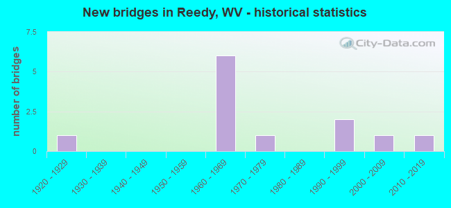
- New bridges - historical statistics
- 11920-1929
- 61960-1969
- 11970-1979
- 21990-1999
- 12000-2009
- 12010-2019

- Bridge Condition - Deck
- 60.0%Good
- 30.0%Satisfactory
- 10.0%Serious

- Bridge Condition - Superstructure
- 27.3%Good
- 36.4%Satisfactory
- 18.2%Fair
- 18.2%Poor

- Bridge Condition - Substructure
- 45.5%Good
- 36.4%Fair
- 18.2%Poor

- Bridge Condition - Channel
- 58.3%Good
- 25.0%Satisfactory
- 16.7%Fair
Find on map >> Show street view
Structure Number: 44A001, Location: 0.02 MILE WEST OF CR 1/1 (Lat: 38.904839, Lng: -81.478481), Route carried "on" structure: County highway 1, Year Built: 1995, Status: Open, Structure Length: 1.75m (5.74ft), Average Daily Traffic: 250 (year 2018), Truck Traffic: 7%, Average Future Daily Traffic: 293 (year 2038), Design Load: HS 25 or greater, Features Intersected: SUGARCAMP RUN
Minimum Vertical Clearance: 30+ m (98+ ft), Kilometerpoint: 4.844, Lanes on structure: 2, Owner: State Highway Agency, Approaching Roadway Width: 5.2m (17.1ft), Skew: 2 degrees, Material/Design: Prestressed concrete, Design/Construction: Box Beam or Girders - Multiple, Number Of Spans In Main Unit: 1, Length of Maximum Span: 17.1m (56.1ft), Curb-To-Curb Width: 7.2m (23.6ft), Out-to-Out Width: 7.4m (24.3ft)
Condition: Deck: Satisfactory, Superstructure: Satisfactory, Substructure: Good, Channel: Good, Operating Rating: 78.9 metric tons, Method Used To Determine Operating Rating: Load Factor (LF), Inventory Rating: 47.2 metric tons, Method Used To Determine Inventory Rating: Load Factor (LF), Structural Evaluation: Equal to present minimum criteria, Deck Geometry: Meets minimum limits, Waterway Adequacy: Equal to present desirable criteria, Approach Roadway Alignment: Better than present minimum criteria, Length Of Structure Improvement: 1.77m (5.81ft), Designated Inspection Frequency: Every 48 months, Inspection Date: Febuary 2021, Bridge Improvement Cost: $200,000, Roadway Improvement Cost: $50,000, Total Project Cost: $250,000 ( Estimate for 2017), Deck Structure Type: Other, Wearing Surface/Protective System: Wearing Surface: Monolithic Concrete, Deck Protection: Epoxy Coated Reinforcing
Find on map >> Show street view
Structure Number: 44A002, Location: 0.08 MI NORTH OF CR 1 (Lat: 38.904669, Lng: -81.460369), Route carried "on" structure: County highway 14, Year Built: 1961, Status: Posted for load, Structure Length: 0.74m (2.43ft), Average Daily Traffic: 30 (year 2019), Average Future Daily Traffic: 48 (year 2039), Features Intersected: MASTERS RUN, Facility Carried by Structure: CR 1/4
Minimum Vertical Clearance: 30+ m (98+ ft), Kilometerpoint: 0.129, Lanes on structure: 1, Owner: State Highway Agency, Approaching Roadway Width: 3.0m (9.8ft), Skew: 4 degrees, Material/Design: Steel, Design/Construction: Stringer/Multi-beam, Number Of Spans In Main Unit: 1, Length of Maximum Span: 6.5m (21.3ft), Curb-To-Curb Width: 4.2m (13.8ft), Out-to-Out Width: 4.3m (14.1ft)
Condition: Deck: Satisfactory, Superstructure: Satisfactory, Substructure: Fair, Channel: Good, Operating Rating: 44.4 metric tons, Method Used To Determine Operating Rating: Load Factor (LF), Inventory Rating: 26.3 metric tons, Method Used To Determine Inventory Rating: Load Factor (LF), Structural Evaluation: Somewhat better than minimum adequacy, Deck Geometry: Somewhat better than minimum adequacy, Waterway Adequacy: Better than present minimum criteria, Approach Roadway Alignment: Equal to present desirable criteria, Length Of Structure Improvement: 1.37m (4.49ft), Designated Inspection Frequency: Every 24 months, Inspection Date: October 2021, Bridge Improvement Cost: $135,000, Roadway Improvement Cost: $15,000, Total Project Cost: $150,000, Deck Structure Type: Corrugated Steel, Wearing Surface/Protective System: Wearing Surface: Gravel
Find on map >> Show street view
Structure Number: 44A003, Location: 0.86 M NORTH OF US 33 (Lat: 38.846000, Lng: -81.454281), Route carried "on" structure: County highway 3, Year Built: 1923, Status: Open, Structure Length: 1.52m (4.99ft), Average Daily Traffic: 250 (year 2019), Truck Traffic: 7%, Average Future Daily Traffic: 400 (year 2039), Features Intersected: MIDDLE FORK OF REEDY CRK
Minimum Vertical Clearance: 30+ m (98+ ft), Kilometerpoint: 1.384, Lanes on structure: 2, Owner: State Highway Agency, Approaching Roadway Width: 4.3m (14.1ft), Material/Design: Concrete, Design/Construction: Arch - Deck, Number Of Spans In Main Unit: 1, Length of Maximum Span: 15.2m (49.9ft), Curb-To-Curb Width: 5.1m (16.7ft), Out-to-Out Width: 5.3m (17.4ft)
Condition: Superstructure: Fair, Substructure: Fair, Channel: Satisfactory, Operating Rating: 41.7 metric tons, Method Used To Determine Operating Rating: Field evaluation and documented engineering judgment, Inventory Rating: 17.2 metric tons, Method Used To Determine Inventory Rating: Field evaluation and documented engineering judgment, Structural Evaluation: Somewhat better than minimum adequacy, Deck Geometry: High priority of replacement, Waterway Adequacy: Equal to present minimum criteria, Approach Roadway Alignment: Equal to present minimum criteria, Length Of Structure Improvement: 2.29m (7.51ft), Designated Inspection Frequency: Every 24 months, Inspection Date: September 2021, Bridge Improvement Cost: $240,000, Roadway Improvement Cost: $110,000, Total Project Cost: $350,000, Deck Structure Type: Concrete Cast-file-Place
Find on map >> Show street view
Structure Number: 44A005, Location: 0.03 M SOUTH OF CR 3/6 (Lat: 38.858219, Lng: -81.451311), Route carried "on" structure: County highway 3, Year Built: 1961, Status: Posted for load, Structure Length: 0.74m (2.43ft), Average Daily Traffic: 250 (year 2019), Truck Traffic: 7%, Average Future Daily Traffic: 295 (year 2039), Features Intersected: STAATS RUN
Minimum Vertical Clearance: 30+ m (98+ ft), Kilometerpoint: 4.152, Lanes on structure: 1, Owner: State Highway Agency, Approaching Roadway Width: 4.0m (13.1ft), Material/Design: Steel continuous, Design/Construction: Stringer/Multi-beam, Number Of Spans In Main Unit: 1, Number Of Approach Spans: 1, Length of Maximum Span: 3.6m (11.8ft), Curb-To-Curb Width: 4.8m (15.7ft), Out-to-Out Width: 4.9m (16.1ft)
Condition: Deck: Satisfactory, Superstructure: Poor, Substructure: Fair, Channel: Good, Operating Rating: 31.7 metric tons, Method Used To Determine Operating Rating: Load Factor (LF), Inventory Rating: 19.0 metric tons, Method Used To Determine Inventory Rating: Load Factor (LF), Structural Evaluation: Meets minimum limits, Deck Geometry: High priority of corrective action, Waterway Adequacy: Equal to present minimum criteria, Approach Roadway Alignment: Better than present minimum criteria, Bridge Posting: Required (Relationship of Operating Rating to Maximum Legal Load: 10.0 - 19.9% below), Length Of Structure Improvement: 1.07m (3.51ft), Designated Inspection Frequency: Every 24 months, Critical Feature Inspection Frequency: Every 24 months, Inspection Date: June 2021, Critical Feature Inspection Date: June 2021, Bridge Improvement Cost: $202,000, Roadway Improvement Cost: $95,000, Total Project Cost: $297,000, Deck Structure Type: Corrugated Steel, Wearing Surface/Protective System: Wearing Surface: Bituminous
Find on map >> Show street view
Structure Number: 44A006, Location: 0.01 MI SOUTH OF CR 1 (Lat: 38.899019, Lng: -81.424800), Route carried "on" structure: County highway 3, Year Built: 1961, Status: Temporarily open, Structure Length: 1.50m (4.92ft), Average Daily Traffic: 300 (year 2018), Truck Traffic: 7%, Average Future Daily Traffic: 351 (year 2038), Features Intersected: RIGHT FORK OF REEDY CK
Minimum Vertical Clearance: 30+ m (98+ ft), Kilometerpoint: 10.429, Lanes on structure: 2, Owner: State Highway Agency, Approaching Roadway Width: 3.7m (12.1ft), Material/Design: Steel, Design/Construction: Stringer/Multi-beam, Number Of Spans In Main Unit: 1, Length of Maximum Span: 14.6m (47.9ft), Curb-To-Curb Width: 5.4m (17.7ft), Out-to-Out Width: 5.5m (18.0ft)
Condition: Deck: Good, Superstructure: Fair, Substructure: Good, Channel: Good, Structural Evaluation: High priority of replacement, Deck Geometry: High priority of replacement, Waterway Adequacy: Somewhat better than minimum adequacy, Approach Roadway Alignment: Meets minimum limits, Length Of Structure Improvement: 1.52m (4.99ft), Designated Inspection Frequency: Every 24 months, Inspection Date: Febuary 2020, Bridge Improvement Cost: $450,000, Roadway Improvement Cost: $50,000, Total Project Cost: $500,000 ( Estimate for 2014), Deck Structure Type: Corrugated Steel, Wearing Surface/Protective System: Wearing Surface: Bituminous
Find on map >> Show street view
Structure Number: 44A007, Location: 0.11 MI WEST OF CR 1 (Lat: 38.895800, Lng: -81.453061), Route carried "on" structure: County highway 4, Year Built: 1960, Status: Posted for load, Structure Length: 0.91m (2.99ft), Average Daily Traffic: 200 (year 2018), Truck Traffic: 7%, Average Future Daily Traffic: 262 (year 2038), Features Intersected: RIGHT FORK REEDY CREEK
Minimum Vertical Clearance: 30+ m (98+ ft), Kilometerpoint: 9.833, Lanes on structure: 1, Owner: State Highway Agency, Approaching Roadway Width: 3.7m (12.1ft), Skew: 2 degrees, Material/Design: Steel, Design/Construction: Stringer/Multi-beam, Number Of Spans In Main Unit: 1, Length of Maximum Span: 8.7m (28.5ft), Curb-To-Curb Width: 4.8m (15.7ft), Out-to-Out Width: 4.9m (16.1ft)
Condition: Deck: Good, Superstructure: Satisfactory, Substructure: Poor, Channel: Fair, Operating Rating: 44.4 metric tons, Method Used To Determine Operating Rating: Load Factor (LF), Inventory Rating: 26.3 metric tons, Method Used To Determine Inventory Rating: Load Factor (LF), Structural Evaluation: Meets minimum limits, Deck Geometry: High priority of corrective action, Waterway Adequacy: Better than present minimum criteria, Approach Roadway Alignment: Equal to present minimum criteria, Length Of Structure Improvement: 1.52m (4.99ft), Designated Inspection Frequency: Every 24 months, Inspection Date: August 2020, Bridge Improvement Cost: $650,000, Roadway Improvement Cost: $50,000, Total Project Cost: $700,000 ( Estimate for 2016), Deck Structure Type: Corrugated Steel, Wearing Surface/Protective System: Wearing Surface: Bituminous
Find on map >> Show street view
Structure Number: 44A036, Location: 0.02 MI NORTH OF CR 14/3 (Lat: 38.900450, Lng: -81.422989), Route carried "on" structure: State highway 14, Year Built: 1960, Status: Posted for load, Structure Length: 6.02m (19.75ft), Average Daily Traffic: 1,100 (year 2019), Truck Traffic: 6%, Average Future Daily Traffic: 1,254 (year 2039), Design Load: HS 15, Features Intersected: REEDY CREEK
Minimum Vertical Clearance: 30+ m (98+ ft), Kilometerpoint: 15.884, Lanes on structure: 2, Owner: State Highway Agency, Approaching Roadway Width: 7.6m (24.9ft), Skew: 4 degrees, Material/Design: Steel continuous, Design/Construction: Stringer/Multi-beam, Number Of Spans In Main Unit: 1, Number Of Approach Spans: 2, Length of Maximum Span: 23.5m (77.1ft), Curb or Sidewalk Widths: Left: 0.9m (3.0ft), Right: 0.9m (3.0ft), Curb-To-Curb Width: 8.5m (27.9ft), Out-to-Out Width: 11.1m (36.4ft)
Condition: Deck: Serious, Superstructure: Poor, Substructure: Fair, Channel: Satisfactory, Operating Rating: 37.2 metric tons, Method Used To Determine Operating Rating: Load Factor (LF), Inventory Rating: 21.8 metric tons, Method Used To Determine Inventory Rating: Load Factor (LF), Structural Evaluation: Meets minimum limits, Deck Geometry: Somewhat better than minimum adequacy, Waterway Adequacy: Equal to present minimum criteria, Approach Roadway Alignment: Better than present minimum criteria, Bridge Posting: Required (Relationship of Operating Rating to Maximum Legal Load: 20.0 - 29.9% below), Length Of Structure Improvement: 5.94m (19.49ft), Designated Inspection Frequency: Every 24 months, Inspection Date: July 2021, Bridge Improvement Cost: $1,800,000, Roadway Improvement Cost: $600,000, Total Project Cost: $2,400,000, Deck Structure Type: Concrete Cast-file-Place, Wearing Surface/Protective System: Wearing Surface: Bituminous
Find on map >> Show street view
Structure Number: 44A037, Location: 0.06 MILE SOUTH OF CR 2 (Lat: 38.915931, Lng: -81.419769), Route carried "on" structure: State highway 14, Year Built: 1977, Status: Open, Structure Length: 0.89m (2.92ft), Average Daily Traffic: 900 (year 2018), Truck Traffic: 6%, Average Future Daily Traffic: 1,053 (year 2038), Design Load: HS 20, Features Intersected: CAIN RUN
Minimum Vertical Clearance: 30+ m (98+ ft), Kilometerpoint: 18.153, Lanes on structure: 2, Owner: State Highway Agency, Approaching Roadway Width: 7.9m (25.9ft), Skew: 2 degrees, Material/Design: Steel, Design/Construction: Culvert, Number Of Spans In Main Unit: 2, Length of Maximum Span: 3.8m (12.5ft)
Condition: Channel: Satisfactory, Culverts: Good, Operating Rating: 71.7 metric tons, Method Used To Determine Operating Rating: Field evaluation and documented engineering judgment, Inventory Rating: 32.7 metric tons, Method Used To Determine Inventory Rating: Field evaluation and documented engineering judgment, Structural Evaluation: Better than present minimum criteria, Waterway Adequacy: Equal to present minimum criteria, Approach Roadway Alignment: Better than present minimum criteria, Designated Inspection Frequency: Every 48 months, Inspection Date: Febuary 2021
Find on map >> Show street view
Structure Number: 44A141, Location: 0.08 MILE SOUTH OF WV 14 (Lat: 38.853800, Lng: -81.402800), Route carried "on" structure: County highway 10, Year Built: 1997, Status: Open, Structure Length: 1.88m (6.17ft), Average Daily Traffic: 150 (year 2019), Truck Traffic: 7%, Average Future Daily Traffic: 240 (year 2039), Design Load: HS 25 or greater, Features Intersected: REEDY CREEK
Minimum Vertical Clearance: 30+ m (98+ ft), Kilometerpoint: 7.339, Lanes on structure: 2, Owner: State Highway Agency, Approaching Roadway Width: 5.2m (17.1ft), Material/Design: Prestressed concrete, Design/Construction: Box Beam or Girders - Multiple, Number Of Spans In Main Unit: 1, Length of Maximum Span: 17.7m (58.1ft), Curb-To-Curb Width: 6.2m (20.3ft), Out-to-Out Width: 6.6m (21.7ft)
Condition: Deck: Good, Superstructure: Good, Substructure: Good, Channel: Good, Operating Rating: 83.4 metric tons, Method Used To Determine Operating Rating: Load Factor (LF), Inventory Rating: 49.9 metric tons, Method Used To Determine Inventory Rating: Load Factor (LF), Structural Evaluation: Better than present minimum criteria, Deck Geometry: Meets minimum limits, Waterway Adequacy: Equal to present minimum criteria, Approach Roadway Alignment: Equal to present minimum criteria, Designated Inspection Frequency: Every 48 months, Inspection Date: November 2021, Deck Structure Type: Other, Wearing Surface/Protective System: Wearing Surface: Bituminous, Deck Protection: Epoxy Coated Reinforcing
Find on map >> Show street view
Structure Number: 44A163, Location: 0.05 MILE S OF CR 3/8 (Lat: 38.849689, Lng: -81.456219), Route carried "on" structure: County highway 3, Year Built: 2004, Status: Open, Structure Length: 1.15m (3.77ft), Average Daily Traffic: 306 (year 2017), Truck Traffic: 7%, Average Future Daily Traffic: 389 (year 2037), Design Load: HS 25 or greater, Features Intersected: LONG RUN
Minimum Vertical Clearance: 30+ m (98+ ft), Kilometerpoint: 2.977, Lanes on structure: 2, Owner: State Highway Agency, Approaching Roadway Width: 5.2m (17.1ft), Skew: 2 degrees, Material/Design: Prestressed concrete, Design/Construction: Box Beam or Girders - Multiple, Number Of Spans In Main Unit: 1, Length of Maximum Span: 10.4m (34.1ft), Curb-To-Curb Width: 7.3m (24.0ft), Out-to-Out Width: 7.5m (24.6ft)
Condition: Deck: Good, Superstructure: Good, Substructure: Good, Channel: Good, Operating Rating: 85.3 metric tons, Method Used To Determine Operating Rating: Load Factor (LF), Inventory Rating: 50.8 metric tons, Method Used To Determine Inventory Rating: Load Factor (LF), Structural Evaluation: Better than present minimum criteria, Deck Geometry: Somewhat better than minimum adequacy, Waterway Adequacy: Equal to present minimum criteria, Approach Roadway Alignment: Better than present minimum criteria, Length Of Structure Improvement: 1.16m (3.81ft), Designated Inspection Frequency: Every 48 months, Inspection Date: December 2018, Bridge Improvement Cost: $600,000, Roadway Improvement Cost: $50,000, Total Project Cost: $650,000 ( Estimate for 2015), Deck Structure Type: Other, Wearing Surface/Protective System: Wearing Surface: Monolithic Concrete, Deck Protection: Epoxy Coated Reinforcing
Find on map >> Show street view
Structure Number: 53A027, Location: 0.30 MI NORTH WV 14 (Lat: 38.931881, Lng: -81.400339), Route carried "on" structure: County highway 28, Year Built: 1966, Status: Posted for load, Structure Length: 0.74m (2.43ft), Average Daily Traffic: 40 (year 2019), Average Future Daily Traffic: 50 (year 2039), Features Intersected: CONRAD RUN
Minimum Vertical Clearance: 30+ m (98+ ft), Kilometerpoint: 0.483, Lanes on structure: 1, Owner: State Highway Agency, Approaching Roadway Width: 5.5m (18.0ft), Material/Design: Steel, Design/Construction: Stringer/Multi-beam, Number Of Spans In Main Unit: 1, Length of Maximum Span: 6.7m (22.0ft), Curb-To-Curb Width: 4.2m (13.8ft), Out-to-Out Width: 4.3m (14.1ft)
Condition: Deck: Good, Superstructure: Satisfactory, Substructure: Poor, Channel: Fair, Operating Rating: 25.4 metric tons, Method Used To Determine Operating Rating: Load Factor (LF), Inventory Rating: 14.5 metric tons, Method Used To Determine Inventory Rating: Load Factor (LF), Structural Evaluation: Meets minimum limits, Deck Geometry: Somewhat better than minimum adequacy, Waterway Adequacy: Somewhat better than minimum adequacy, Approach Roadway Alignment: Equal to present minimum criteria, Bridge Posting: Required (Relationship of Operating Rating to Maximum Legal Load: > 39.9% below), Length Of Structure Improvement: 1.46m (4.79ft), Designated Inspection Frequency: Every 24 months, Critical Feature Inspection Frequency: Every 24 months, Inspection Date: May 2021, Critical Feature Inspection Date: May 2021, Bridge Improvement Cost: $165,000, Roadway Improvement Cost: $1,000, Total Project Cost: $166,000, Deck Structure Type: Corrugated Steel, Wearing Surface/Protective System: Wearing Surface: Bituminous
Find on map >> Show street view
Structure Number: 53A066, Location: 0.04 MI S of C.R. 38 (Lat: 38.929731, Lng: -81.397539), Route carried "on" structure: State highway 14, Year Built: 2012, Status: Open, Structure Length: 4.52m (14.83ft), Average Daily Traffic: 700 (year 2018), Truck Traffic: 6%, Average Future Daily Traffic: 861 (year 2038), Design Load: HL 93, Features Intersected: Reedy Creek
Minimum Vertical Clearance: 30+ m (98+ ft), Kilometerpoint: 2.575, Lanes on structure: 2, Owner: State Highway Agency, Approaching Roadway Width: 7.9m (25.9ft), Material/Design: Steel, Design/Construction: Truss - Thru, Number Of Spans In Main Unit: 1, Length of Maximum Span: 43.9m (144.0ft), Curb-To-Curb Width: 9.8m (32.2ft), Out-to-Out Width: 10.5m (34.4ft)
Condition: Deck: Good, Superstructure: Good, Substructure: Good, Channel: Good, Operating Rating: 41.7 metric tons, Method Used To Determine Operating Rating: Load and Resistance Factor (LRFR), Inventory Rating: 32.7 metric tons, Method Used To Determine Inventory Rating: Load and Resistance Factor (LRFR), Structural Evaluation: Better than present minimum criteria, Deck Geometry: Equal to present minimum criteria, Waterway Adequacy: Equal to present minimum criteria, Approach Roadway Alignment: Equal to present desirable criteria, Length Of Structure Improvement: 4.39m (14.40ft), Designated Inspection Frequency: Every 24 months, Critical Feature Inspection Frequency: Every 24 months, Inspection Date: March 2021, Critical Feature Inspection Date: March 2021, Deck Structure Type: Concrete Cast-file-Place, Wearing Surface/Protective System: Wearing Surface: Monolithic Concrete, Deck Protection: Epoxy Coated Reinforcing