Bridge Statistics for Richfield, Utah (UT)
Condition, Traffic, Stress, Structural Evaluation, Project Costs
- National Bridge Inventory (NBI) Statistics
- 38Number of bridges
- 197ft / 60.2mTotal length
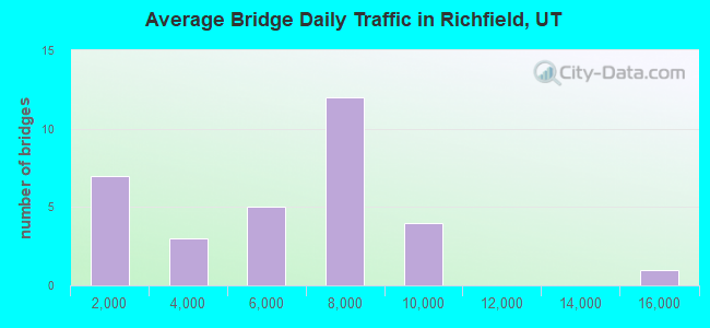
- 169,411Total average daily traffic
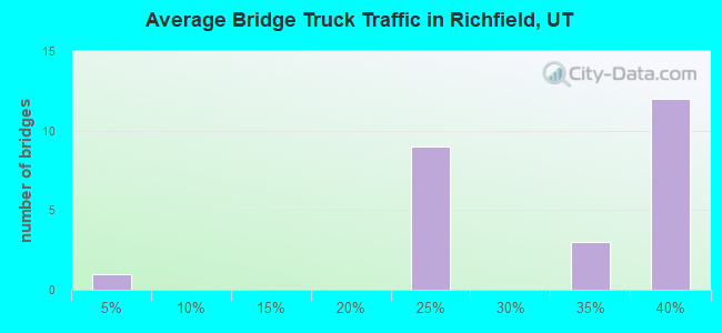
- 50,598Total average daily truck traffic
- National Bridge Inventory (NBI) Registered Bridges for Richfield
- No street view available for this location
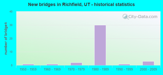
- New bridges - historical statistics
- 11950-1959
- 11960-1969
- 21970-1979
- 301980-1989
- 11990-1999
- 32000-2009
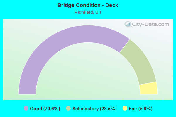
- Bridge Condition - Deck
- 70.6%Good
- 23.5%Satisfactory
- 5.9%Fair
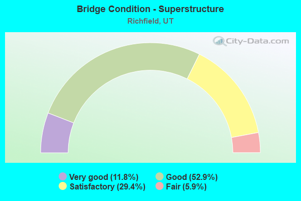
- Bridge Condition - Superstructure
- 11.8%Very good
- 52.9%Good
- 29.4%Satisfactory
- 5.9%Fair
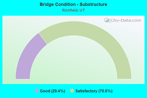
- Bridge Condition - Substructure
- 29.4%Good
- 70.6%Satisfactory
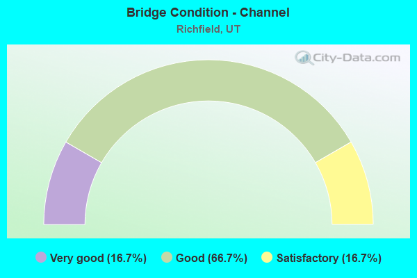
- Bridge Condition - Channel
- 16.7%Very good
- 66.7%Good
- 16.7%Satisfactory
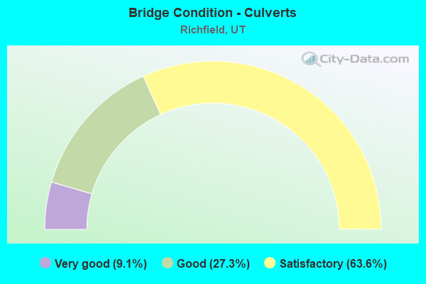
- Bridge Condition - Culverts
- 9.1%Very good
- 27.3%Good
- 63.6%Satisfactory
Find on map >> Show street view
Structure Number: 41017F, Location: 500 SO. SEGMILLAR LANE (Lat: 38.761692, Lng: -112.038444), Route carried "on" structure: County highway , Year Built: 1991, Status: Open, Structure Length: 1.44m (4.72ft), Average Daily Traffic: 95 (year 2020), Average Future Daily Traffic: 115 (year 2040), Design Load: HS 20+Mod, Features Intersected: SEVIER RIVER, Facility Carried by Structure: COUNTY ROAD
Minimum Vertical Clearance: 30+ m (98+ ft), Kilometerpoint: 0.488, Lanes on structure: 2, Owner: County Highway Agency, Approaching Roadway Width: 7.9m (25.9ft), Material/Design: Prestressed concrete, Design/Construction: Tee Beam, Number Of Spans In Main Unit: 1, Length of Maximum Span: 13.5m (44.3ft), Curb-To-Curb Width: 7.9m (25.9ft), Out-to-Out Width: 8.9m (29.2ft)
Condition: Deck: Satisfactory, Superstructure: Good, Substructure: Good, Channel: Good, Operating Rating: 32.4 metric tons, Method Used To Determine Operating Rating: Load and Resistance Factor Rating (LRFR) rating reported by rating factor(RF) method using HL-93 loadings, Inventory Rating: 23.0 metric tons, Method Used To Determine Inventory Rating: Load Factor (LF) rating reported by rating factor (RF) method using MS18 loading, Structural Evaluation: Equal to present minimum criteria, Deck Geometry: Equal to present minimum criteria, Waterway Adequacy: Better than present minimum criteria, Approach Roadway Alignment: Equal to present desirable criteria, Designated Inspection Frequency: Every 22 months, Inspection Date: July 2020, Deck Structure Type: Concrete Precast Panels, Wearing Surface/Protective System: Wearing Surface: Monolithic Concrete
Find on map >> Show street view
Structure Number: 41019E, Location: 1.5 MI.NORTH OF RICHFIELD (Lat: 38.788400, Lng: -112.076300), Route carried "on" structure: County highway 2551, Year Built: 1989, Status: Open, Structure Length: 0.78m (2.56ft), Average Daily Traffic: 486 (year 2020), Average Future Daily Traffic: 608 (year 2040), Design Load: HL 93, Features Intersected: SEVIER VALLEY CANAL, Facility Carried by Structure: COUNTY ROAD
Minimum Vertical Clearance: 30+ m (98+ ft), Kilometerpoint: 3.655, Lanes on structure: 2, Owner: County Highway Agency, Approaching Roadway Width: 8.2m (26.9ft), Skew: 4 degrees, Material/Design: Concrete, Design/Construction: Culvert, Number Of Spans In Main Unit: 1, Length of Maximum Span: 7.2m (23.6ft), Curb-To-Curb Width: 8.2m (26.9ft), Out-to-Out Width: 14.0m (45.9ft)
Condition: Channel: Good, Culverts: Good, Operating Rating: 32.4 metric tons, Method Used To Determine Operating Rating: Load and Resistance Factor Rating (LRFR) rating reported by rating factor(RF) method using HL-93 loadings, Inventory Rating: 19.8 metric tons, Method Used To Determine Inventory Rating: Load Factor (LF) rating reported by rating factor (RF) method using MS18 loading, Structural Evaluation: Somewhat better than minimum adequacy, Deck Geometry: Somewhat better than minimum adequacy, Waterway Adequacy: Equal to present minimum criteria, Approach Roadway Alignment: Equal to present desirable criteria, Designated Inspection Frequency: Every 22 months, Inspection Date: July 2020
Find on map >> Show street view
Structure Number: 41039C, Location: 450 WEST 620 NORTH (Lat: 38.776953, Lng: -112.093092), Route carried "on" structure: City street , Year Built: 1970, Status: Posted for load, Structure Length: 0.88m (2.89ft), Average Daily Traffic: 643 (year 2020), Truck Traffic: 1%, Average Future Daily Traffic: 781 (year 2040), Design Load: HS 20+Mod, Features Intersected: SEVIER VALLEY CANAL, Facility Carried by Structure: CITY STREET
Minimum Vertical Clearance: 30+ m (98+ ft), Kilometerpoint: 0.004, Lanes on structure: 2, Owner: City or Municipal Highway Agency, Approaching Roadway Width: 9.3m (30.5ft), Material/Design: Steel, Design/Construction: Stringer/Multi-beam, Number Of Spans In Main Unit: 1, Length of Maximum Span: 7.3m (24.0ft), Curb-To-Curb Width: 9.3m (30.5ft), Out-to-Out Width: 9.3m (30.5ft)
Condition: Deck: Satisfactory, Superstructure: Fair, Substructure: Good, Channel: Good, Operating Rating: 27.2 metric tons, Method Used To Determine Operating Rating: Load Factor (LF) rating reported by rating factor (RF) method using MS18 loading, Inventory Rating: 20.1 metric tons, Method Used To Determine Inventory Rating: Load Factor (LF) rating reported by rating factor (RF) method using MS18 loading, Structural Evaluation: Somewhat better than minimum adequacy, Deck Geometry: Equal to present minimum criteria, Waterway Adequacy: Equal to present minimum criteria, Approach Roadway Alignment: Equal to present minimum criteria, Bridge Posting: Required (Relationship of Operating Rating to Maximum Legal Load: 10.0 - 19.9% below), Designated Inspection Frequency: Every 22 months, Inspection Date: July 2020, Deck Structure Type: Corrugated Steel, Wearing Surface/Protective System: Wearing Surface: Bituminous
Find on map >> Show street view
Structure Number: 41040C, Location: 700 N. 300 W., RICHFIELD (Lat: 38.776900, Lng: -112.090100), Route carried "on" structure: City street 2553, Year Built: 1968, Status: Open, Structure Length: 0.73m (2.40ft), Average Daily Traffic: 695 (year 2020), Average Future Daily Traffic: 869 (year 2040), Design Load: H 15, Features Intersected: SEVIER VALLEY CANAL, Facility Carried by Structure: 300 WEST STREET
Minimum Vertical Clearance: 30+ m (98+ ft), Kilometerpoint: 0.202, Lanes on structure: 2, Owner: City or Municipal Highway Agency, Approaching Roadway Width: 14.6m (47.9ft), Material/Design: Steel, Design/Construction: Stringer/Multi-beam, Number Of Spans In Main Unit: 1, Length of Maximum Span: 7.0m (23.0ft), Curb-To-Curb Width: 7.3m (24.0ft), Out-to-Out Width: 8.2m (26.9ft)
Condition: Deck: Satisfactory, Superstructure: Satisfactory, Substructure: Good, Channel: Good, Operating Rating: 11.0 metric tons, Method Used To Determine Operating Rating: Load Factor (LF) rating reported by rating factor (RF) method using MS18 loading, Inventory Rating: 8.1 metric tons, Method Used To Determine Inventory Rating: Load Factor (LF) rating reported by rating factor (RF) method using MS18 loading, Structural Evaluation: High priority of corrective action, Deck Geometry: Meets minimum limits, Waterway Adequacy: Equal to present minimum criteria, Approach Roadway Alignment: Equal to present minimum criteria, Bridge Posting: Required (Relationship of Operating Rating to Maximum Legal Load: > 39.9% below), Designated Inspection Frequency: Every 22 months, Inspection Date: July 2020, Deck Structure Type: Corrugated Steel, Wearing Surface/Protective System: Wearing Surface: Bituminous
Find on map >> Show street view
Structure Number: 41055A, Location: NE SIDE OF RICHFIELD (Lat: 38.760864, Lng: -112.083125), Route carried "on" structure: Alternate City street , Year Built: 1980, Status: Posted for load, Structure Length: 0.88m (2.89ft), Average Daily Traffic: 63 (year 2020), Average Future Daily Traffic: 77 (year 2040), Design Load: HS 20+Mod, Features Intersected: SEVIER VALLEY CANAL, Facility Carried by Structure: 480 SOUTH 100 EAST
Minimum Vertical Clearance: 30+ m (98+ ft), Kilometerpoint: 0.042, Lanes on structure: 1, Owner: City or Municipal Highway Agency, Approaching Roadway Width: 3.4m (11.2ft), Skew: 4 degrees, Material/Design: Wood or Timber, Design/Construction: Stringer/Multi-beam, Number Of Spans In Main Unit: 1, Length of Maximum Span: 7.5m (24.6ft), Curb-To-Curb Width: 3.4m (11.2ft), Out-to-Out Width: 4.7m (15.4ft)
Condition: Deck: Fair, Superstructure: Satisfactory, Substructure: Good, Channel: Good, Operating Rating: 46.7 metric tons, Method Used To Determine Operating Rating: Load and Resistance Factor Rating (LRFR) rating reported by rating factor(RF) method using HL-93 loadings, Inventory Rating: 41.8 metric tons, Method Used To Determine Inventory Rating: Load and Resistance Factor Rating (LRFR) rating reported by rating factor(RF) method using HL-93 loadings, Structural Evaluation: Equal to present minimum criteria, Deck Geometry: High priority of corrective action, Waterway Adequacy: Equal to present desirable criteria, Approach Roadway Alignment: Better than present minimum criteria, Designated Inspection Frequency: Every 22 months, Inspection Date: July 2020, Deck Structure Type: Other, Wearing Surface/Protective System: Wearing Surface: Wood or Timber
Find on map >> Show street view
Structure Number: 41057E, Location: 700 WEST 300 NORTH (Lat: 38.772292, Lng: -112.097514), Route carried "on" structure: City street 2549, Year Built: 2008, Status: Open, Structure Length: 0.70m (2.30ft), Average Daily Traffic: 2,072 (year 2020), Average Future Daily Traffic: 2,590 (year 2040), Design Load: HS 20+Mod, Features Intersected: SEVIER VALLEY CANAL, Facility Carried by Structure: 300 NORTH STREET
Minimum Vertical Clearance: 30+ m (98+ ft), Kilometerpoint: 0.054, Lanes on structure: 2, Owner: City or Municipal Highway Agency, Approaching Roadway Width: 8.5m (27.9ft), Skew: 2 degrees, Material/Design: Concrete, Design/Construction: Culvert, Number Of Spans In Main Unit: 1, Length of Maximum Span: 6.5m (21.3ft)
Condition: Channel: Satisfactory, Culverts: Good, Operating Rating: 34.3 metric tons, Method Used To Determine Operating Rating: Load and Resistance Factor Rating (LRFR) rating reported by rating factor(RF) method using HL-93 loadings, Inventory Rating: 33.4 metric tons, Method Used To Determine Inventory Rating: Load Factor (LF) rating reported by rating factor (RF) method using MS18 loading, Structural Evaluation: Better than present minimum criteria, Waterway Adequacy: Better than present minimum criteria, Approach Roadway Alignment: Equal to present desirable criteria, Designated Inspection Frequency: Every 22 months, Inspection Date: July 2020
Find on map >> Show street view
Structure Number: 41058E, Location: WEST SIDE OF RICHFIELD (Lat: 38.770750, Lng: -112.098814), Route carried "on" structure: Alternate City street 2559, Year Built: 2008, Status: Open, Structure Length: 0.97m (3.18ft), Average Daily Traffic: 1,959 (year 2020), Average Future Daily Traffic: 2,449 (year 2040), Design Load: HS 20+Mod, Features Intersected: SEVIER VALLEY CANAL, Facility Carried by Structure: COLLEGE AVENUE
Minimum Vertical Clearance: 30+ m (98+ ft), Kilometerpoint: 2.562, Lanes on structure: 2, Owner: City or Municipal Highway Agency, Approaching Roadway Width: 9.1m (29.9ft), Skew: 4 degrees, Material/Design: Concrete, Design/Construction: Culvert, Number Of Spans In Main Unit: 1, Length of Maximum Span: 8.9m (29.2ft), Curb or Sidewalk Widths: Left: 0.0m, Right: 3.0m (9.8ft)
Condition: Channel: Very good, Culverts: Satisfactory, Operating Rating: 33.7 metric tons, Method Used To Determine Operating Rating: Load and Resistance Factor Rating (LRFR) rating reported by rating factor(RF) method using HL-93 loadings, Inventory Rating: 27.5 metric tons, Method Used To Determine Inventory Rating: Load and Resistance Factor Rating (LRFR) rating reported by rating factor(RF) method using HL-93 loadings, Structural Evaluation: Equal to present minimum criteria, Waterway Adequacy: Equal to present desirable criteria, Approach Roadway Alignment: Equal to present desirable criteria, Designated Inspection Frequency: Every 22 months, Inspection Date: July 2020
Find on map >> Show street view
Structure Number: 41059E, Location: 500 N. 700 W. (Lat: 38.774986, Lng: -112.097094), Route carried "on" structure: City street 2559, Year Built: 2008, Status: Posted for load, Structure Length: 0.81m (2.66ft), Average Daily Traffic: 1,959 (year 2020), Average Future Daily Traffic: 2,449 (year 2040), Design Load: HS 20+Mod, Features Intersected: SEVIER VALLEY CANAL, Facility Carried by Structure: 500 NORTH STREET
Minimum Vertical Clearance: 30+ m (98+ ft), Kilometerpoint: 3.057, Lanes on structure: 2, Owner: City or Municipal Highway Agency, Approaching Roadway Width: 8.5m (27.9ft), Skew: 3 degrees, Material/Design: Concrete, Design/Construction: Culvert, Number Of Spans In Main Unit: 1, Length of Maximum Span: 7.4m (24.3ft)
Condition: Channel: Good, Culverts: Satisfactory, Operating Rating: 33.7 metric tons, Method Used To Determine Operating Rating: Load and Resistance Factor Rating (LRFR) rating reported by rating factor(RF) method using HL-93 loadings, Inventory Rating: 26.9 metric tons, Method Used To Determine Inventory Rating: Load and Resistance Factor Rating (LRFR) rating reported by rating factor(RF) method using HL-93 loadings, Structural Evaluation: Equal to present minimum criteria, Waterway Adequacy: Equal to present desirable criteria, Approach Roadway Alignment: Equal to present desirable criteria, Designated Inspection Frequency: Every 22 months, Inspection Date: July 2020
Find on map >> Show street view
Structure Number: E1047, Location: SOUTH MAIN IN RICHFIELD (Lat: 38.759514, Lng: -112.084775), Route carried "on" structure: State highway 120, Year Built: 1956, Year Reconstructed: 1997, Status: Open, Structure Length: 1.21m (3.97ft), Average Daily Traffic: 15,884 (year 2020), Truck Traffic: 23%, Average Future Daily Traffic: 19,855 (year 2040), Design Load: H 15, Features Intersected: RICHFIELD CANAL
Minimum Vertical Clearance: 30+ m (98+ ft), Kilometerpoint: 2.761, Lanes on structure: 4, Owner: State Highway Agency, Approaching Roadway Width: 24.4m (80.1ft), Skew: 26 degrees, Material/Design: Concrete, Design/Construction: Culvert, Number Of Spans In Main Unit: 1, Length of Maximum Span: 11.6m (38.1ft), Curb-To-Curb Width: 24.4m (80.1ft), Out-to-Out Width: 48.4m (158.8ft)
Condition: Channel: Satisfactory, Culverts: Satisfactory, Operating Rating: 32.4 metric tons, Method Used To Determine Operating Rating: Load Factor (LF) rating reported by rating factor (RF) method using MS18 loading, Inventory Rating: 32.1 metric tons, Method Used To Determine Inventory Rating: Load Factor (LF) rating reported by rating factor (RF) method using MS18 loading, Structural Evaluation: Equal to present minimum criteria, Deck Geometry: Superior to present desirable criteria, Waterway Adequacy: Somewhat better than minimum adequacy, Approach Roadway Alignment: Equal to present desirable criteria, Designated Inspection Frequency: Every 24 months, Inspection Date: May 2021, Deck Structure Type: Concrete Cast-file-Place, Wearing Surface/Protective System: Wearing Surface: Low Slump Concrete
Find on map >> Show street view
Structure Number: E2079, Location: NO.MAIN ST.IN RICHFIELD (Lat: 38.778989, Lng: -112.084744), Route carried "on" structure: State highway 120, Year Built: 1978, Status: Open, Structure Length: 0.78m (2.56ft), Average Daily Traffic: 9,418 (year 2020), Truck Traffic: 22%, Average Future Daily Traffic: 11,773 (year 2040), Design Load: HS 20+Mod, Features Intersected: STATE CANAL
Minimum Vertical Clearance: 30+ m (98+ ft), Kilometerpoint: 4.923, Lanes on structure: 5, Owner: State Highway Agency, Approaching Roadway Width: 23.8m (78.1ft), Skew: 23 degrees, Material/Design: Concrete, Design/Construction: Culvert, Number Of Spans In Main Unit: 1, Length of Maximum Span: 7.1m (23.3ft), Curb or Sidewalk Widths: Left: 2.7m (8.9ft), Right: 2.0m (6.6ft)
Condition: Channel: Good, Culverts: Satisfactory, Operating Rating: 33.7 metric tons, Method Used To Determine Operating Rating: Load Factor (LF) rating reported by rating factor (RF) method using MS18 loading, Inventory Rating: 31.1 metric tons, Method Used To Determine Inventory Rating: Load Factor (LF) rating reported by rating factor (RF) method using MS18 loading, Structural Evaluation: Equal to present minimum criteria, Waterway Adequacy: Equal to present minimum criteria, Approach Roadway Alignment: Equal to present desirable criteria, Designated Inspection Frequency: Every 24 months, Inspection Date: May 2021, Wearing Surface/Protective System: Wearing Surface: Bituminous
Find on map >> Show street view
Structure Number: E2171, Location: 2.2 MI. E. OF RICHFIELD (Lat: 38.773294, Lng: -112.044003), Route carried "on" structure: State highway 119, Year Built: 1981, Status: Open, Structure Length: 0.78m (2.56ft), Average Daily Traffic: 2,004 (year 2020), Truck Traffic: 20%, Average Future Daily Traffic: 2,505 (year 2040), Design Load: HS 20+Mod, Features Intersected: VERMILLION CANAL
Minimum Vertical Clearance: 30+ m (98+ ft), Kilometerpoint: 2.162, Lanes on structure: 2, Owner: State Highway Agency, Approaching Roadway Width: 12.2m (40.0ft), Skew: 5 degrees, Material/Design: Concrete, Design/Construction: Culvert, Number Of Spans In Main Unit: 1, Length of Maximum Span: 7.1m (23.3ft)
Condition: Channel: Very good, Culverts: Satisfactory, Operating Rating: 35.6 metric tons, Method Used To Determine Operating Rating: Load Factor (LF) rating reported by rating factor (RF) method using MS18 loading, Inventory Rating: 31.1 metric tons, Method Used To Determine Inventory Rating: Load Factor (LF) rating reported by rating factor (RF) method using MS18 loading, Structural Evaluation: Equal to present minimum criteria, Waterway Adequacy: Equal to present minimum criteria, Approach Roadway Alignment: Equal to present desirable criteria, Designated Inspection Frequency: Every 24 months, Inspection Date: May 2021
Find on map >> Show street view
Structure Number: E2299, Location: S. SIDE OF RICHFIELD (Lat: 38.749758, Lng: -112.095583), Route carried "on" structure: State highway 120, Year Built: 1986, Status: Open, Structure Length: 0.69m (2.26ft), Average Daily Traffic: 4,530 (year 2020), Truck Traffic: 24%, Average Future Daily Traffic: 5,663 (year 2040), Design Load: HS 20+Mod, Features Intersected: RICHFIELD CANAL
Minimum Vertical Clearance: 30.18m (99.02ft), Kilometerpoint: 0.947, Lanes on structure: 5, Owner: State Highway Agency, Approaching Roadway Width: 24.4m (80.1ft), Skew: 5 degrees, Material/Design: Concrete, Design/Construction: Culvert, Number Of Spans In Main Unit: 1, Length of Maximum Span: 6.4m (21.0ft)
Condition: Channel: Good, Culverts: Satisfactory, Operating Rating: 57.0 metric tons, Method Used To Determine Operating Rating: Load and Resistance Factor Rating (LRFR) rating reported by rating factor(RF) method using HL-93 loadings, Inventory Rating: 36.9 metric tons, Method Used To Determine Inventory Rating: Load and Resistance Factor Rating (LRFR) rating reported by rating factor(RF) method using HL-93 loadings, Structural Evaluation: Equal to present minimum criteria, Waterway Adequacy: Better than present minimum criteria, Approach Roadway Alignment: Equal to present desirable criteria, Designated Inspection Frequency: Every 24 months, Inspection Date: May 2021
Find on map >> Show street view
Structure Number: E2303, Location: 4.4 MI.NO.ELSINORE INTCHG (Lat: 38.719214, Lng: -112.132669), Route carried "on" structure: Interstate 70, Year Built: 1986, Status: Open, Structure Length: 1.84m (6.04ft), Average Daily Traffic: 6,332 (year 2020), Truck Traffic: 33%, Average Future Daily Traffic: 7,915 (year 2040), Design Load: HS 20+Mod, Features Intersected: FLAT CANYON DRAINAGE CH.
Minimum Vertical Clearance: 30+ m (98+ ft), Kilometerpoint: 55.683, Lanes on structure: 4, Base Highway Network: Yes, Owner: State Highway Agency, Approaching Roadway Width: 23.2m (76.1ft), Skew: 24 degrees, Material/Design: Concrete continuous, Design/Construction: Culvert, Number Of Spans In Main Unit: 2, Length of Maximum Span: 8.3m (27.2ft)
Condition: Channel: Good, Culverts: Satisfactory, Operating Rating: 32.4 metric tons, Method Used To Determine Operating Rating: Load Factor (LF) rating reported by rating factor (RF) method using MS18 loading, Inventory Rating: 32.1 metric tons, Method Used To Determine Inventory Rating: Load Factor (LF) rating reported by rating factor (RF) method using MS18 loading, Structural Evaluation: Equal to present minimum criteria, Waterway Adequacy: Better than present minimum criteria, Approach Roadway Alignment: Equal to present desirable criteria, Designated Inspection Frequency: Every 24 months, Inspection Date: May 2021
Find on map >> Show street view
Structure Number: E2306, Location: 4.5 MI.NO.ELSINORE INTCHG (Lat: 38.720925, Lng: -112.131786), Route carried "on" structure: Interstate 70, Year Built: 1986, Status: Open, Structure Length: 0.83m (2.72ft), Average Daily Traffic: 6,332 (year 2020), Truck Traffic: 33%, Average Future Daily Traffic: 7,915 (year 2040), Design Load: HS 20+Mod, Features Intersected: STATE CANAL
Minimum Vertical Clearance: 30.18m (99.02ft), Kilometerpoint: 55.888, Lanes on structure: 4, Base Highway Network: Yes, Owner: State Highway Agency, Approaching Roadway Width: 11.6m (38.1ft), Skew: 23 degrees, Material/Design: Concrete, Design/Construction: Culvert, Number Of Spans In Main Unit: 1, Length of Maximum Span: 4.0m (13.1ft)
Condition: Channel: Good, Culverts: Very good, Operating Rating: 60.9 metric tons, Method Used To Determine Operating Rating: Load and Resistance Factor Rating (LRFR) rating reported by rating factor(RF) method using HL-93 loadings, Inventory Rating: 50.5 metric tons, Method Used To Determine Inventory Rating: Load and Resistance Factor Rating (LRFR) rating reported by rating factor(RF) method using HL-93 loadings, Structural Evaluation: Equal to present desirable criteria, Waterway Adequacy: Better than present minimum criteria, Approach Roadway Alignment: Equal to present desirable criteria, Designated Inspection Frequency: Every 24 months, Inspection Date: May 2021
Find on map >> Show street view
Structure Number: E2323, Location: .6 MI.NO.SO.RICHFIELD INT (Lat: 38.759428, Lng: -112.105175), Route carried "on" structure: Interstate 70, Year Built: 1987, Status: Open, Structure Length: 0.90m (2.95ft), Average Daily Traffic: 6,893 (year 2020), Truck Traffic: 35%, Average Future Daily Traffic: 8,616 (year 2040), Design Load: HS 20+Mod, Features Intersected: STATE CANAL
Minimum Vertical Clearance: 30+ m (98+ ft), Kilometerpoint: 60.972, Lanes on structure: 4, Base Highway Network: Yes, Owner: State Highway Agency, Approaching Roadway Width: 21.9m (71.9ft), Skew: 24 degrees, Material/Design: Concrete continuous, Design/Construction: Culvert, Number Of Spans In Main Unit: 2, Length of Maximum Span: 4.1m (13.5ft)
Condition: Channel: Good, Culverts: Good, Operating Rating: 48.0 metric tons, Method Used To Determine Operating Rating: Load and Resistance Factor Rating (LRFR) rating reported by rating factor(RF) method using HL-93 loadings, Inventory Rating: 38.6 metric tons, Method Used To Determine Inventory Rating: Load and Resistance Factor Rating (LRFR) rating reported by rating factor(RF) method using HL-93 loadings, Structural Evaluation: Better than present minimum criteria, Waterway Adequacy: Better than present minimum criteria, Approach Roadway Alignment: Equal to present desirable criteria, Designated Inspection Frequency: Every 24 months, Inspection Date: May 2021
Find on map >> Show street view
Structure Number: F 467, Location: 2.9 MI.EAST OF RICHFIELD (Lat: 38.774011, Lng: -112.030372), Route carried "on" structure: State highway 119, Year Built: 1981, Status: Open, Structure Length: 2.15m (7.05ft), Average Daily Traffic: 2,004 (year 2020), Truck Traffic: 20%, Average Future Daily Traffic: 2,505 (year 2040), Design Load: HS 20+Mod, Features Intersected: SEVIER RIVER
Minimum Vertical Clearance: 30+ m (98+ ft), Kilometerpoint: 3.350, Lanes on structure: 2, Owner: State Highway Agency, Approaching Roadway Width: 12.3m (40.4ft), Material/Design: Prestressed concrete, Design/Construction: Stringer/Multi-beam, Number Of Spans In Main Unit: 1, Length of Maximum Span: 20.7m (67.9ft), Curb-To-Curb Width: 12.3m (40.4ft), Out-to-Out Width: 12.9m (42.3ft)
Condition: Deck: Good, Superstructure: Satisfactory, Substructure: Satisfactory, Channel: Satisfactory, Operating Rating: 34.0 metric tons, Method Used To Determine Operating Rating: Load and Resistance Factor Rating (LRFR) rating reported by rating factor(RF) method using HL-93 loadings, Inventory Rating: 30.8 metric tons, Method Used To Determine Inventory Rating: Load Factor (LF) rating reported by rating factor (RF) method using MS18 loading, Structural Evaluation: Equal to present minimum criteria, Deck Geometry: Equal to present minimum criteria, Waterway Adequacy: Meets minimum limits, Approach Roadway Alignment: Equal to present desirable criteria, Designated Inspection Frequency: Every 24 months, Inspection Date: May 2021, Deck Structure Type: Concrete Cast-file-Place, Wearing Surface/Protective System: Wearing Surface: Bituminous, Deck Protection: Epoxy Coated Reinforcing
Find on map >> Show street view
Structure Number: 2F 525, Location: SOUTH RICHFIELD INTCHG. (Lat: 38.749825, Lng: -112.105683), Route carried "on" structure: Interstate 70, Year Built: 1988, Status: Open, Structure Length: 4.32m (14.17ft), Average Daily Traffic: 6,332 (year 2020), Truck Traffic: 33%, Average Future Daily Traffic: 7,915 (year 2040), Design Load: HS 20+Mod, Features Intersected: SR-120, INTCHG.X-ROAD
Minimum Vertical Clearance: 30+ m (98+ ft), Kilometerpoint: 59.900, Lanes on structure: 2, Lanes under structure: 4, Base Highway Network: Yes, Owner: State Highway Agency, Approaching Roadway Width: 12.4m (40.7ft), Skew: 11 degrees, Material/Design: Prestressed concrete, Design/Construction: Stringer/Multi-beam, Number Of Spans In Main Unit: 1, Length of Maximum Span: 42.7m (140.1ft), Curb-To-Curb Width: 12.4m (40.7ft), Out-to-Out Width: 13.5m (44.3ft)
Condition: Deck: Good, Superstructure: Good, Substructure: Satisfactory, Operating Rating: 35.6 metric tons, Method Used To Determine Operating Rating: Load and Resistance Factor Rating (LRFR) rating reported by rating factor(RF) method using HL-93 loadings, Inventory Rating: 31.8 metric tons, Method Used To Determine Inventory Rating: Load and Resistance Factor Rating (LRFR) rating reported by rating factor(RF) method using HL-93 loadings, Structural Evaluation: Equal to present minimum criteria, Deck Geometry: Better than present minimum criteria, Underclear: Equal to present minimum criteria, Approach Roadway Alignment: Equal to present desirable criteria, Designated Inspection Frequency: Every 24 months, Inspection Date: May 2021, Deck Structure Type: Concrete Cast-file-Place, Wearing Surface/Protective System: Wearing Surface: Monolithic Concrete, Deck Protection: Epoxy Coated Reinforcing
Find on map >> Show street view
Structure Number: 2F 532, Location: NORTH RICHFIELD INTCHG. (Lat: 38.789556, Lng: -112.083364), Route carried "on" structure: Interstate 70, Year Built: 1988, Status: Open, Structure Length: 4.35m (14.27ft), Average Daily Traffic: 6,893 (year 2020), Truck Traffic: 35%, Average Future Daily Traffic: 8,616 (year 2040), Design Load: HS 20+Mod, Features Intersected: SR-120, INTCHG.X-ROAD
Minimum Vertical Clearance: 30+ m (98+ ft), Kilometerpoint: 64.945, Lanes on structure: 2, Lanes under structure: 3, Base Highway Network: Yes, Owner: State Highway Agency, Approaching Roadway Width: 12.4m (40.7ft), Skew: 11 degrees, Material/Design: Prestressed concrete, Design/Construction: Stringer/Multi-beam, Number Of Spans In Main Unit: 1, Length of Maximum Span: 42.7m (140.1ft), Curb-To-Curb Width: 12.4m (40.7ft), Out-to-Out Width: 13.4m (44.0ft)
Condition: Deck: Good, Superstructure: Good, Substructure: Satisfactory, Operating Rating: 84.9 metric tons, Method Used To Determine Operating Rating: Load and Resistance Factor Rating (LRFR) rating reported by rating factor(RF) method using HL-93 loadings, Inventory Rating: 38.2 metric tons, Method Used To Determine Inventory Rating: Load Factor (LF) rating reported by rating factor (RF) method using MS18 loading, Structural Evaluation: Equal to present minimum criteria, Deck Geometry: Better than present minimum criteria, Underclear: Equal to present minimum criteria, Approach Roadway Alignment: Equal to present desirable criteria, Designated Inspection Frequency: Every 24 months, Inspection Date: May 2021, Deck Structure Type: Concrete Cast-file-Place, Wearing Surface/Protective System: Wearing Surface: Epoxy Overlay, Membrane: Epoxy, Deck Protection: Epoxy Coated Reinforcing
Find on map >> Show street view
Structure Number: 2F 533, Location: 2.2 MI.N.NO.RICHFIELD INT (Lat: 38.812858, Lng: -112.054511), Route carried "on" structure: Interstate 70, Year Built: 1989, Status: Open, Structure Length: 3.08m (10.10ft), Average Daily Traffic: 9,548 (year 2020), Truck Traffic: 38%, Average Future Daily Traffic: 11,935 (year 2040), Design Load: HS 20+Mod, Features Intersected: WILLOW CREEK ACCESS ROAD
Minimum Vertical Clearance: 30+ m (98+ ft), Kilometerpoint: 68.568, Lanes on structure: 2, Lanes under structure: 2, Base Highway Network: Yes, Owner: State Highway Agency, Approaching Roadway Width: 12.4m (40.7ft), Skew: 11 degrees, Material/Design: Prestressed concrete, Design/Construction: Stringer/Multi-beam, Number Of Spans In Main Unit: 1, Length of Maximum Span: 30.0m (98.4ft), Curb-To-Curb Width: 12.4m (40.7ft), Out-to-Out Width: 13.4m (44.0ft)
Condition: Deck: Good, Superstructure: Very good, Substructure: Satisfactory, Operating Rating: 32.4 metric tons, Method Used To Determine Operating Rating: Load and Resistance Factor Rating (LRFR) rating reported by rating factor(RF) method using HL-93 loadings, Inventory Rating: 29.2 metric tons, Method Used To Determine Inventory Rating: Load and Resistance Factor Rating (LRFR) rating reported by rating factor(RF) method using HL-93 loadings, Structural Evaluation: Equal to present minimum criteria, Deck Geometry: Better than present minimum criteria, Underclear: Somewhat better than minimum adequacy, Approach Roadway Alignment: Equal to present desirable criteria, Designated Inspection Frequency: Every 24 months, Inspection Date: May 2021, Deck Structure Type: Concrete Cast-file-Place, Wearing Surface/Protective System: Wearing Surface: Epoxy Overlay, Deck Protection: Epoxy Coated Reinforcing
Find on map >> Show street view
Structure Number: 2F 534, Location: .7 MI.NO.SO.RICHFIELD INT (Lat: 38.761158, Lng: -112.105028), Route carried "on" structure: Interstate 70, Year Built: 1988, Status: Open, Structure Length: 3.18m (10.43ft), Average Daily Traffic: 6,893 (year 2020), Truck Traffic: 35%, Average Future Daily Traffic: 8,616 (year 2040), Design Load: HS 20+Mod, Features Intersected: 500 SOUTH ST. RICHFIELD
Minimum Vertical Clearance: 30+ m (98+ ft), Kilometerpoint: 61.165, Lanes on structure: 2, Lanes under structure: 2, Base Highway Network: Yes, Owner: State Highway Agency, Approaching Roadway Width: 12.4m (40.7ft), Skew: 13 degrees, Material/Design: Prestressed concrete, Design/Construction: Stringer/Multi-beam, Number Of Spans In Main Unit: 1, Length of Maximum Span: 30.9m (101.4ft), Curb-To-Curb Width: 12.4m (40.7ft), Out-to-Out Width: 13.4m (44.0ft)
Condition: Deck: Good, Superstructure: Satisfactory, Substructure: Satisfactory, Operating Rating: 44.1 metric tons, Method Used To Determine Operating Rating: Load and Resistance Factor Rating (LRFR) rating reported by rating factor(RF) method using HL-93 loadings, Inventory Rating: 37.6 metric tons, Method Used To Determine Inventory Rating: Load Factor (LF) rating reported by rating factor (RF) method using MS18 loading, Structural Evaluation: Equal to present minimum criteria, Deck Geometry: Better than present minimum criteria, Underclear: Somewhat better than minimum adequacy, Approach Roadway Alignment: Equal to present desirable criteria, Designated Inspection Frequency: Every 24 months, Inspection Date: May 2021, Deck Structure Type: Concrete Cast-file-Place, Wearing Surface/Protective System: Wearing Surface: Monolithic Concrete, Membrane: Epoxy, Deck Protection: Epoxy Coated Reinforcing
Find on map >> Show street view
Structure Number: 2F 535, Location: 1.5 MI.N.SO.RICHFIELD INT (Lat: 38.772108, Lng: -112.098914), Route carried "on" structure: Interstate 70, Year Built: 1988, Status: Open, Structure Length: 2.96m (9.71ft), Average Daily Traffic: 6,893 (year 2020), Truck Traffic: 35%, Average Future Daily Traffic: 8,616 (year 2040), Design Load: HS 20+Mod, Features Intersected: 300 NORTH ST. RICHFIELD
Minimum Vertical Clearance: 30+ m (98+ ft), Kilometerpoint: 62.494, Lanes on structure: 2, Lanes under structure: 2, Base Highway Network: Yes, Owner: State Highway Agency, Approaching Roadway Width: 12.4m (40.7ft), Skew: 12 degrees, Material/Design: Prestressed concrete, Design/Construction: Stringer/Multi-beam, Number Of Spans In Main Unit: 1, Length of Maximum Span: 28.8m (94.5ft), Curb-To-Curb Width: 12.4m (40.7ft), Out-to-Out Width: 13.4m (44.0ft)
Condition: Deck: Good, Superstructure: Good, Substructure: Satisfactory, Operating Rating: 51.2 metric tons, Method Used To Determine Operating Rating: Load and Resistance Factor Rating (LRFR) rating reported by rating factor(RF) method using HL-93 loadings, Inventory Rating: 41.5 metric tons, Method Used To Determine Inventory Rating: Load Factor (LF) rating reported by rating factor (RF) method using MS18 loading, Structural Evaluation: Equal to present minimum criteria, Deck Geometry: Better than present minimum criteria, Underclear: Somewhat better than minimum adequacy, Approach Roadway Alignment: Equal to present desirable criteria, Designated Inspection Frequency: Every 24 months, Inspection Date: May 2021, Deck Structure Type: Concrete Cast-file-Place, Wearing Surface/Protective System: Wearing Surface: Monolithic Concrete, Membrane: Epoxy, Deck Protection: Epoxy Coated Reinforcing
Find on map >> Show street view
Structure Number: 2F 537, Location: S0.of NO.RICHFIELD INTCH. (Lat: 38.786006, Lng: -112.090292), Route carried "on" structure: Interstate 70, Year Built: 1988, Status: Open, Structure Length: 4.04m (13.25ft), Average Daily Traffic: 6,893 (year 2020), Truck Traffic: 35%, Average Future Daily Traffic: 8,616 (year 2040), Design Load: HS 20+Mod, Features Intersected: COTTONWOOD CANYON WASH
Minimum Vertical Clearance: 30+ m (98+ ft), Kilometerpoint: 64.219, Lanes on structure: 2, Base Highway Network: Yes, Owner: State Highway Agency, Approaching Roadway Width: 12.8m (42.0ft), Skew: 10 degrees, Material/Design: Prestressed concrete, Design/Construction: Stringer/Multi-beam, Number Of Spans In Main Unit: 1, Length of Maximum Span: 39.6m (129.9ft), Curb-To-Curb Width: 12.8m (42.0ft), Out-to-Out Width: 13.7m (44.9ft)
Condition: Deck: Good, Superstructure: Good, Substructure: Satisfactory, Channel: Good, Operating Rating: 50.9 metric tons, Method Used To Determine Operating Rating: Load and Resistance Factor Rating (LRFR) rating reported by rating factor(RF) method using HL-93 loadings, Inventory Rating: 37.9 metric tons, Method Used To Determine Inventory Rating: Load Factor (LF) rating reported by rating factor (RF) method using MS18 loading, Structural Evaluation: Equal to present minimum criteria, Deck Geometry: Equal to present desirable criteria, Waterway Adequacy: Better than present minimum criteria, Approach Roadway Alignment: Equal to present desirable criteria, Designated Inspection Frequency: Every 24 months, Inspection Date: May 2021, Deck Structure Type: Concrete Cast-file-Place, Wearing Surface/Protective System: Wearing Surface: Monolithic Concrete, Membrane: Epoxy, Deck Protection: Epoxy Coated Reinforcing
Find on map >> Show street view
Structure Number: 4F 525, Location: SOUTH RICHFIELD INTCHG. (Lat: 38.750344, Lng: -112.105894), Route carried "on" structure: Interstate 70, Year Built: 1988, Status: Open, Structure Length: 4.32m (14.17ft), Average Daily Traffic: 6,893 (year 2020), Truck Traffic: 35%, Average Future Daily Traffic: 8,616 (year 2040), Design Load: HS 20+Mod, Features Intersected: SR-120, INTCHG.X-ROAD
Minimum Vertical Clearance: 30+ m (98+ ft), Kilometerpoint: 60.020, Lanes on structure: 2, Lanes under structure: 4, Base Highway Network: Yes, Owner: State Highway Agency, Approaching Roadway Width: 12.4m (40.7ft), Skew: 11 degrees, Material/Design: Prestressed concrete, Design/Construction: Stringer/Multi-beam, Number Of Spans In Main Unit: 1, Length of Maximum Span: 42.7m (140.1ft), Curb-To-Curb Width: 12.4m (40.7ft), Out-to-Out Width: 13.5m (44.3ft)
Condition: Deck: Good, Superstructure: Good, Substructure: Satisfactory, Operating Rating: 35.6 metric tons, Method Used To Determine Operating Rating: Load and Resistance Factor Rating (LRFR) rating reported by rating factor(RF) method using HL-93 loadings, Inventory Rating: 31.8 metric tons, Method Used To Determine Inventory Rating: Load and Resistance Factor Rating (LRFR) rating reported by rating factor(RF) method using HL-93 loadings, Structural Evaluation: Equal to present minimum criteria, Deck Geometry: Better than present minimum criteria, Underclear: Equal to present minimum criteria, Approach Roadway Alignment: Equal to present desirable criteria, Designated Inspection Frequency: Every 24 months, Inspection Date: May 2021, Deck Structure Type: Concrete Cast-file-Place, Wearing Surface/Protective System: Wearing Surface: Epoxy Overlay, Membrane: Epoxy, Deck Protection: Epoxy Coated Reinforcing
Find on map >> Show street view
Structure Number: 4F 532, Location: NORTH RICHFIELD INTCHG. (Lat: 38.790064, Lng: -112.082822), Route carried "on" structure: Interstate 70, Year Built: 1988, Status: Open, Structure Length: 4.35m (14.27ft), Average Daily Traffic: 9,548 (year 2020), Truck Traffic: 38%, Average Future Daily Traffic: 11,935 (year 2040), Design Load: HS 20+Mod, Features Intersected: SR-120, INTCHG.X-ROAD
Minimum Vertical Clearance: 30+ m (98+ ft), Kilometerpoint: 65.110, Lanes on structure: 2, Lanes under structure: 3, Base Highway Network: Yes, Owner: State Highway Agency, Approaching Roadway Width: 12.4m (40.7ft), Skew: 11 degrees, Material/Design: Prestressed concrete, Design/Construction: Stringer/Multi-beam, Number Of Spans In Main Unit: 1, Length of Maximum Span: 42.7m (140.1ft), Curb-To-Curb Width: 12.4m (40.7ft), Out-to-Out Width: 13.4m (44.0ft)
Condition: Deck: Good, Superstructure: Good, Substructure: Satisfactory, Operating Rating: 84.9 metric tons, Method Used To Determine Operating Rating: Load Factor (LF) rating reported by rating factor (RF) method using MS18 loading, Inventory Rating: 38.2 metric tons, Method Used To Determine Inventory Rating: Load Factor (LF) rating reported by rating factor (RF) method using MS18 loading, Structural Evaluation: Equal to present minimum criteria, Deck Geometry: Better than present minimum criteria, Underclear: Equal to present minimum criteria, Approach Roadway Alignment: Equal to present desirable criteria, Designated Inspection Frequency: Every 24 months, Inspection Date: May 2021, Deck Structure Type: Concrete Cast-file-Place, Wearing Surface/Protective System: Wearing Surface: Epoxy Overlay, Membrane: Epoxy, Deck Protection: Epoxy Coated Reinforcing
Find on map >> Show street view
Structure Number: 4F 533, Location: 2.2 MI.N.NO.RICHFIELD INT (Lat: 38.813339, Lng: -112.054614), Route carried "on" structure: Interstate 70, Year Built: 1989, Status: Open, Structure Length: 3.08m (10.10ft), Average Daily Traffic: 9,548 (year 2020), Truck Traffic: 38%, Average Future Daily Traffic: 11,935 (year 2040), Design Load: HS 20+Mod, Features Intersected: WILLOW CREEK ACCESS ROAD
Minimum Vertical Clearance: 30+ m (98+ ft), Kilometerpoint: 68.686, Lanes on structure: 2, Lanes under structure: 2, Base Highway Network: Yes, Owner: State Highway Agency, Approaching Roadway Width: 12.4m (40.7ft), Skew: 11 degrees, Material/Design: Prestressed concrete, Design/Construction: Stringer/Multi-beam, Number Of Spans In Main Unit: 1, Length of Maximum Span: 30.0m (98.4ft), Curb-To-Curb Width: 12.4m (40.7ft), Out-to-Out Width: 13.4m (44.0ft)
Condition: Deck: Satisfactory, Superstructure: Very good, Substructure: Good, Operating Rating: 32.4 metric tons, Method Used To Determine Operating Rating: Load and Resistance Factor Rating (LRFR) rating reported by rating factor(RF) method using HL-93 loadings, Inventory Rating: 29.2 metric tons, Method Used To Determine Inventory Rating: Load and Resistance Factor Rating (LRFR) rating reported by rating factor(RF) method using HL-93 loadings, Structural Evaluation: Better than present minimum criteria, Deck Geometry: Better than present minimum criteria, Underclear: Somewhat better than minimum adequacy, Approach Roadway Alignment: Equal to present desirable criteria, Designated Inspection Frequency: Every 24 months, Inspection Date: May 2021, Deck Structure Type: Concrete Cast-file-Place, Wearing Surface/Protective System: Wearing Surface: Monolithic Concrete, Deck Protection: Epoxy Coated Reinforcing
Find on map >> Show street view
Structure Number: 4F 534, Location: .7 MI.NO.SO.RICHFIELD INT (Lat: 38.761786, Lng: -112.105206), Route carried "on" structure: Interstate 70, Year Built: 1988, Status: Open, Structure Length: 3.18m (10.43ft), Average Daily Traffic: 6,893 (year 2020), Truck Traffic: 35%, Average Future Daily Traffic: 8,616 (year 2040), Design Load: HS 20+Mod, Features Intersected: 500 S0UTH ST. RICHFIELD
Minimum Vertical Clearance: 30+ m (98+ ft), Kilometerpoint: 61.297, Lanes on structure: 2, Lanes under structure: 2, Base Highway Network: Yes, Owner: State Highway Agency, Approaching Roadway Width: 12.4m (40.7ft), Skew: 13 degrees, Material/Design: Prestressed concrete, Design/Construction: Stringer/Multi-beam, Number Of Spans In Main Unit: 1, Length of Maximum Span: 30.9m (101.4ft), Curb-To-Curb Width: 12.4m (40.7ft), Out-to-Out Width: 13.4m (44.0ft)
Condition: Deck: Good, Superstructure: Satisfactory, Substructure: Satisfactory, Operating Rating: 44.1 metric tons, Method Used To Determine Operating Rating: Load and Resistance Factor Rating (LRFR) rating reported by rating factor(RF) method using HL-93 loadings, Inventory Rating: 38.2 metric tons, Method Used To Determine Inventory Rating: Load Factor (LF) rating reported by rating factor (RF) method using MS18 loading, Structural Evaluation: Equal to present minimum criteria, Deck Geometry: Better than present minimum criteria, Underclear: Somewhat better than minimum adequacy, Approach Roadway Alignment: Equal to present desirable criteria, Designated Inspection Frequency: Every 24 months, Inspection Date: May 2021, Deck Structure Type: Concrete Cast-file-Place, Wearing Surface/Protective System: Wearing Surface: Epoxy Overlay, Membrane: Epoxy, Deck Protection: Epoxy Coated Reinforcing
Find on map >> Show street view
Structure Number: 4F 535, Location: 1.5 MI.N.SO.RICHFIELD INT (Lat: 38.772483, Lng: -112.099106), Route carried "on" structure: Interstate 70, Year Built: 1988, Status: Open, Structure Length: 2.96m (9.71ft), Average Daily Traffic: 6,893 (year 2020), Truck Traffic: 35%, Average Future Daily Traffic: 8,616 (year 2040), Design Load: HS 20+Mod, Features Intersected: 300 NORTH ST. RICHFIELD
Minimum Vertical Clearance: 30+ m (98+ ft), Kilometerpoint: 62.599, Lanes on structure: 2, Lanes under structure: 2, Base Highway Network: Yes, Owner: State Highway Agency, Approaching Roadway Width: 12.4m (40.7ft), Skew: 12 degrees, Material/Design: Prestressed concrete, Design/Construction: Stringer/Multi-beam, Number Of Spans In Main Unit: 1, Length of Maximum Span: 28.8m (94.5ft), Curb-To-Curb Width: 12.4m (40.7ft), Out-to-Out Width: 13.4m (44.0ft)
Condition: Deck: Good, Superstructure: Good, Substructure: Satisfactory, Operating Rating: 46.3 metric tons, Method Used To Determine Operating Rating: Load and Resistance Factor Rating (LRFR) rating reported by rating factor(RF) method using HL-93 loadings, Inventory Rating: 38.2 metric tons, Method Used To Determine Inventory Rating: Load Factor (LF) rating reported by rating factor (RF) method using MS18 loading, Structural Evaluation: Equal to present minimum criteria, Deck Geometry: Better than present minimum criteria, Underclear: Somewhat better than minimum adequacy, Approach Roadway Alignment: Equal to present desirable criteria, Designated Inspection Frequency: Every 24 months, Inspection Date: May 2021, Deck Structure Type: Concrete Cast-file-Place, Wearing Surface/Protective System: Wearing Surface: Epoxy Overlay, Membrane: Epoxy, Deck Protection: Epoxy Coated Reinforcing
Find on map >> Show street view
Structure Number: 4F 537, Location: S.OF N.RICHFIELD INTCH. (Lat: 38.786611, Lng: -112.090197), Route carried "on" structure: Interstate 70, Year Built: 1988, Status: Open, Structure Length: 4.04m (13.25ft), Average Daily Traffic: 6,893 (year 2020), Truck Traffic: 35%, Average Future Daily Traffic: 8,616 (year 2040), Design Load: HS 20+Mod, Features Intersected: COTTONWOOD CANYON WASH
Minimum Vertical Clearance: 30+ m (98+ ft), Kilometerpoint: 64.358, Lanes on structure: 3, Base Highway Network: Yes, Owner: State Highway Agency, Approaching Roadway Width: 17.8m (58.4ft), Skew: 10 degrees, Material/Design: Prestressed concrete, Design/Construction: Stringer/Multi-beam, Number Of Spans In Main Unit: 1, Length of Maximum Span: 39.6m (129.9ft), Curb-To-Curb Width: 17.8m (58.4ft), Out-to-Out Width: 18.7m (61.4ft)
Condition: Deck: Good, Superstructure: Good, Substructure: Satisfactory, Channel: Very good, Operating Rating: 44.7 metric tons, Method Used To Determine Operating Rating: Load and Resistance Factor Rating (LRFR) rating reported by rating factor(RF) method using HL-93 loadings, Inventory Rating: 37.3 metric tons, Method Used To Determine Inventory Rating: Load and Resistance Factor Rating (LRFR) rating reported by rating factor(RF) method using HL-93 loadings, Structural Evaluation: Equal to present minimum criteria, Deck Geometry: Better than present minimum criteria, Waterway Adequacy: Better than present minimum criteria, Approach Roadway Alignment: Equal to present desirable criteria, Designated Inspection Frequency: Every 24 months, Inspection Date: May 2021, Deck Structure Type: Concrete Cast-file-Place, Wearing Surface/Protective System: Wearing Surface: Epoxy Overlay, Membrane: Epoxy, Deck Protection: Epoxy Coated Reinforcing
Find on map >> Show street view
Structure Number: 2F 525, Location: SOUTH RICHFIELD INTCHG. (Lat: 38.749825, Lng: -112.105683), Route carried "under" structure: State highway 120, Year Built: 1988, Structure Length: 0. m, Average Daily Traffic: 4,530 (year 2020), Truck Traffic: 24%, Features Intersected: SR-120, INTCHG.X-ROAD, Facility Carried by Structure: I-70 (SR-70) EBL
Minimum Vertical Clearance: 5.18m (16.99ft), Kilometerpoint: 0.082, Lanes on structure: 2, Lanes under structure: 4, Material/Design: Prestressed concrete, Design/Construction: Stringer/Multi-beam, Length of Maximum Span: 42.7m (140.1ft)
Find on map >> Show street view
Structure Number: 2F 532, Location: NORTH RICHFIELD INTCHG. (Lat: 38.789556, Lng: -112.083364), Route carried "under" structure: State highway 120, Year Built: 1988, Structure Length: 0. m, Average Daily Traffic: 4,431 (year 2020), Truck Traffic: 22%, Features Intersected: SR-120, INTCHG.X-ROAD, Facility Carried by Structure: I-70 (SR-70) EBL
Minimum Vertical Clearance: 4.80m (15.75ft), Kilometerpoint: 6.178, Lanes on structure: 2, Lanes under structure: 3, Material/Design: Prestressed concrete, Design/Construction: Stringer/Multi-beam, Length of Maximum Span: 42.7m (140.1ft)
Find on map >> Show street view
Structure Number: 2F 533, Location: 2.2 MI.N.NO.RICHFIELD INT (Lat: 38.812858, Lng: -112.054511), Route carried "under" structure: County highway , Year Built: 1989, Structure Length: 0. m, Features Intersected: WILLOW CREEK ACCESS ROAD, Facility Carried by Structure: I-70 (SR-70) EBL
Minimum Vertical Clearance: 4.98m (16.34ft), Kilometerpoint: 0.000, Lanes on structure: 2, Lanes under structure: 2, Material/Design: Prestressed concrete, Design/Construction: Stringer/Multi-beam, Length of Maximum Span: 30.0m (98.4ft)
Find on map >> Show street view
Structure Number: 2F 534, Location: .7 MI.NO.SO.RICHFIELD INT (Lat: 38.761158, Lng: -112.105028), Route carried "under" structure: City street , Year Built: 1988, Structure Length: 0. m, Features Intersected: 500 SOUTH ST. RICHFIELD, Facility Carried by Structure: I-70 (SR-70) EBL
Minimum Vertical Clearance: 4.95m (16.24ft), Kilometerpoint: 0.000, Lanes on structure: 2, Lanes under structure: 2, Material/Design: Prestressed concrete, Design/Construction: Stringer/Multi-beam, Length of Maximum Span: 30.9m (101.4ft)
Find on map >> Show street view
Structure Number: 2F 535, Location: 1.5 MI.N.SO.RICHFIELD INT (Lat: 38.772108, Lng: -112.098914), Route carried "under" structure: City street , Year Built: 1988, Structure Length: 0. m, Features Intersected: 300 NORTH ST. RICHFIELD, Facility Carried by Structure: I-70 (SR-70) EBL
Minimum Vertical Clearance: 4.85m (15.91ft), Kilometerpoint: 0.000, Lanes on structure: 2, Lanes under structure: 2, Material/Design: Prestressed concrete, Design/Construction: Stringer/Multi-beam, Length of Maximum Span: 28.8m (94.5ft)
Find on map >> Show street view
Structure Number: 4F 525, Location: SOUTH RICHFIELD INTCHG. (Lat: 38.750344, Lng: -112.105894), Route carried "under" structure: State highway 120, Year Built: 1988, Structure Length: 0. m, Average Daily Traffic: 4,530 (year 2020), Truck Traffic: 24%, Features Intersected: SR-120, INTCHG.X-ROAD, Facility Carried by Structure: I-70 (SR-70) WBL
Minimum Vertical Clearance: 4.95m (16.24ft), Kilometerpoint: 0.048, Lanes on structure: 2, Lanes under structure: 4, Material/Design: Prestressed concrete, Design/Construction: Stringer/Multi-beam, Length of Maximum Span: 42.7m (140.1ft)
Find on map >> Show street view
Structure Number: 4F 532, Location: NORTH RICHFIELD INTCHG. (Lat: 38.790064, Lng: -112.082822), Route carried "under" structure: State highway 120, Year Built: 1988, Structure Length: 0. m, Average Daily Traffic: 4,431 (year 2020), Truck Traffic: 22%, Features Intersected: SR-120, INTCHG.X-ROAD, Facility Carried by Structure: I-70 (SR-70) WBL
Minimum Vertical Clearance: 4.85m (15.91ft), Kilometerpoint: 6.188, Lanes on structure: 2, Lanes under structure: 3, Material/Design: Prestressed concrete, Design/Construction: Stringer/Multi-beam, Length of Maximum Span: 42.7m (140.1ft)
Find on map >> Show street view
Structure Number: 4F 533, Location: 2.2 MI.N.NO.RICHFIELD INT (Lat: 38.813339, Lng: -112.054614), Route carried "under" structure: County highway , Year Built: 1989, Structure Length: 0. m, Features Intersected: WILLOW CREEK ACCESS ROAD, Facility Carried by Structure: I-70 (SR-70) WBL
Minimum Vertical Clearance: 4.89m (16.04ft), Kilometerpoint: 0.000, Lanes on structure: 2, Lanes under structure: 2, Material/Design: Prestressed concrete, Design/Construction: Stringer/Multi-beam, Length of Maximum Span: 30.0m (98.4ft)
Find on map >> Show street view
Structure Number: 4F 534, Location: .7 MI.NO.SO.RICHFIELD INT (Lat: 38.761786, Lng: -112.105206), Route carried "under" structure: City street , Year Built: 1988, Structure Length: 0. m, Features Intersected: 500 S0UTH ST. RICHFIELD, Facility Carried by Structure: I-70 (SR-70) WBL
Minimum Vertical Clearance: 5.18m (16.99ft), Kilometerpoint: 0.000, Lanes on structure: 2, Lanes under structure: 2, Material/Design: Prestressed concrete, Design/Construction: Stringer/Multi-beam, Length of Maximum Span: 30.9m (101.4ft)
Find on map >> Show street view
Structure Number: 4F 535, Location: 1.5 MI.N.SO.RICHFIELD INT (Lat: 38.772483, Lng: -112.099106), Route carried "under" structure: City street , Year Built: 1988, Structure Length: 0. m, Features Intersected: 300 NORTH ST. RICHFIELD, Facility Carried by Structure: I-70 (SR-70) WBL
Minimum Vertical Clearance: 4.85m (15.91ft), Kilometerpoint: 0.000, Lanes on structure: 2, Lanes under structure: 2, Material/Design: Prestressed concrete, Design/Construction: Stringer/Multi-beam, Length of Maximum Span: 28.8m (94.5ft)