Bridge Statistics for Richland Hills, Texas (TX)
Condition, Traffic, Stress, Structural Evaluation, Project Costs
- National Bridge Inventory (NBI) Statistics
- 11Number of bridges
- 157ft / 48.3mTotal length
- 253,082Total average daily traffic
- 14,538Total average daily truck traffic
- National Bridge Inventory (NBI) Registered Bridges for Richland Hills
- No street view available for this location
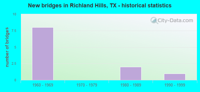
- New bridges - historical statistics
- 81960-1969
- 21980-1989
- 11990-1999


- Bridge Condition - Deck
- 33.3%Very good
- 66.7%Good

- Bridge Condition - Superstructure
- 16.7%Very good
- 50.0%Good
- 33.3%Satisfactory

- Bridge Condition - Substructure
- 33.3%Good
- 66.7%Satisfactory
Find on map >> Show street view
Structure Number: 22200036301046, Location: 0.3 MI SW OF SH 26 (Lat: 32.807628, Lng: -97.248544), Route carried "on" structure: State highway 183, Year Built: 1992, Status: Open, Structure Length: 7.38m (24.21ft), Average Daily Traffic: 17,709 (year 2018), Truck Traffic: 7%, Average Future Daily Traffic: 14,090 (year 2033), Design Load: HS 20, Features Intersected: BIG FOSSIL CREEK
Minimum Vertical Clearance: 30+ m (98+ ft), Kilometerpoint: 2.610, Lanes on structure: 2, Owner: State Highway Agency, Approaching Roadway Width: 11.6m (38.1ft), Material/Design: Prestressed concrete, Design/Construction: Stringer/Multi-beam, Number Of Spans In Main Unit: 1, Number Of Approach Spans: 2, Length of Maximum Span: 33.5m (109.9ft), Curb-To-Curb Width: 11.6m (38.1ft), Out-to-Out Width: 12.2m (40.0ft)
Condition: Deck: Very good, Superstructure: Very good, Substructure: Satisfactory, Channel: Good, Operating Rating: 54.4 metric tons, Method Used To Determine Operating Rating: Assigned rating based on Load Factor Design (LFD) reported in metric tons, Inventory Rating: 32.7 metric tons, Method Used To Determine Inventory Rating: Assigned rating based on Load Factor Design (LFD) reported in metric tons, Structural Evaluation: Equal to present minimum criteria, Deck Geometry: Better than present minimum criteria, Waterway Adequacy: Equal to present desirable criteria, Approach Roadway Alignment: Equal to present desirable criteria, Designated Inspection Frequency: Every 24 months, Inspection Date: June 2020, Deck Structure Type: Concrete Cast-file-Place, Wearing Surface/Protective System: Wearing Surface: Bituminous
Find on map >> Show street view
Structure Number: 22200036301104, Location: 0.6 MI SW OF SPUR 474 (Lat: 32.809875, Lng: -97.245300), Route carried "on" structure: State highway 26, Year Built: 1989, Status: Open, Structure Length: 9.97m (32.71ft), Average Daily Traffic: 15,751 (year 2020), Truck Traffic: 2%, Average Future Daily Traffic: 29,300 (year 2033), Design Load: HS 20, Features Intersected: SH 183 WB
Minimum Vertical Clearance: 30+ m (98+ ft), Kilometerpoint: 4.311, Lanes on structure: 2, Lanes under structure: 2, Base Highway Network: Yes, Owner: State Highway Agency, Approaching Roadway Width: 11.6m (38.1ft), Skew: 9 degrees, Material/Design: Prestressed concrete, Design/Construction: Stringer/Multi-beam, Number Of Spans In Main Unit: 2, Number Of Approach Spans: 3, Length of Maximum Span: 29.0m (95.1ft), Curb-To-Curb Width: 11.3m (37.1ft), Out-to-Out Width: 12.2m (40.0ft)
Condition: Deck: Very good, Superstructure: Good, Substructure: Satisfactory, Operating Rating: 54.4 metric tons, Method Used To Determine Operating Rating: Assigned rating based on Load Factor Design (LFD) reported in metric tons, Inventory Rating: 32.7 metric tons, Method Used To Determine Inventory Rating: Assigned rating based on Load Factor Design (LFD) reported in metric tons, Structural Evaluation: Equal to present minimum criteria, Deck Geometry: Equal to present minimum criteria, Underclear: Equal to present minimum criteria, Approach Roadway Alignment: Equal to present desirable criteria, Designated Inspection Frequency: Every 24 months, Inspection Date: June 2020, Deck Structure Type: Concrete Cast-file-Place, Wearing Surface/Protective System: Wearing Surface: Bituminous
Find on map >> Show street view
Structure Number: 22200036303022, Location: 0.5 MI NE OF MINNIS DR (Lat: 32.794811, Lng: -97.236461), Route carried "on" structure: State highway 121, Year Built: 1967, Status: Open, Structure Length: 10.67m (35.01ft), Average Daily Traffic: 49,062 (year 2019), Truck Traffic: 5%, Average Future Daily Traffic: 66,450 (year 2033), Design Load: HS 20, Features Intersected: FOSSIL CREEK & MIDWAY
Minimum Vertical Clearance: 30+ m (98+ ft), Kilometerpoint: 4.928, Lanes on structure: 3, Lanes under structure: 2, Base Highway Network: Yes, Owner: State Highway Agency, Approaching Roadway Width: 15.9m (52.2ft), Material/Design: Prestressed concrete, Design/Construction: Stringer/Multi-beam, Number Of Spans In Main Unit: 5, Length of Maximum Span: 21.3m (69.9ft), Curb-To-Curb Width: 15.9m (52.2ft), Out-to-Out Width: 16.4m (53.8ft)
Condition: Deck: Good, Superstructure: Good, Substructure: Satisfactory, Channel: Good, Operating Rating: 54.4 metric tons, Method Used To Determine Operating Rating: Assigned rating based on Load Factor Design (LFD) reported in metric tons, Inventory Rating: 32.7 metric tons, Method Used To Determine Inventory Rating: Assigned rating based on Load Factor Design (LFD) reported in metric tons, Structural Evaluation: Equal to present minimum criteria, Deck Geometry: Somewhat better than minimum adequacy, Underclear: Meets minimum limits, Waterway Adequacy: Superior to present desirable criteria, Approach Roadway Alignment: Equal to present desirable criteria, Designated Inspection Frequency: Every 24 months, Inspection Date: June 2020, Deck Structure Type: Concrete Cast-file-Place, Wearing Surface/Protective System: Wearing Surface: Bituminous
Find on map >> Show street view
Structure Number: 22200036303023, Location: 0.5 MI NE OF MINNIS DR. (Lat: 32.794711, Lng: -97.236453), Route carried "on" structure: State highway 121, Year Built: 1967, Status: Open, Structure Length: 10.67m (35.01ft), Average Daily Traffic: 52,031 (year 2019), Truck Traffic: 5%, Average Future Daily Traffic: 66,450 (year 2033), Design Load: HS 20, Features Intersected: FOSSIL CREEK & MIDWAY
Minimum Vertical Clearance: 30+ m (98+ ft), Kilometerpoint: 4.928, Lanes on structure: 3, Lanes under structure: 2, Base Highway Network: Yes, Owner: State Highway Agency, Approaching Roadway Width: 15.9m (52.2ft), Material/Design: Prestressed concrete, Design/Construction: Stringer/Multi-beam, Number Of Spans In Main Unit: 5, Length of Maximum Span: 21.3m (69.9ft), Curb-To-Curb Width: 15.9m (52.2ft), Out-to-Out Width: 16.4m (53.8ft)
Condition: Deck: Good, Superstructure: Good, Substructure: Satisfactory, Channel: Good, Operating Rating: 54.4 metric tons, Method Used To Determine Operating Rating: Assigned rating based on Load Factor Design (LFD) reported in metric tons, Inventory Rating: 32.7 metric tons, Method Used To Determine Inventory Rating: Assigned rating based on Load Factor Design (LFD) reported in metric tons, Structural Evaluation: Equal to present minimum criteria, Deck Geometry: Somewhat better than minimum adequacy, Underclear: Meets minimum limits, Waterway Adequacy: Superior to present desirable criteria, Approach Roadway Alignment: Equal to present desirable criteria, Designated Inspection Frequency: Every 24 months, Inspection Date: June 2020, Deck Structure Type: Concrete Cast-file-Place, Wearing Surface/Protective System: Wearing Surface: Bituminous
Find on map >> Show street view
Structure Number: 22200036303024, Location: SH121 HANDLEY EDERVILLE (Lat: 32.801303, Lng: -97.221108), Route carried "on" structure: State highway 121, Year Built: 1967, Status: Open, Structure Length: 4.82m (15.81ft), Average Daily Traffic: 48,155 (year 2019), Truck Traffic: 9%, Average Future Daily Traffic: 52,620 (year 2033), Design Load: HS 20, Features Intersected: HANDLEY EDERVILLE RD
Minimum Vertical Clearance: 30+ m (98+ ft), Kilometerpoint: 3.367, Lanes on structure: 3, Lanes under structure: 5, Base Highway Network: Yes, Owner: State Highway Agency, Approaching Roadway Width: 15.9m (52.2ft), Skew: 2 degrees, Material/Design: Prestressed concrete, Design/Construction: Stringer/Multi-beam, Number Of Spans In Main Unit: 1, Number Of Approach Spans: 2, Length of Maximum Span: 20.7m (67.9ft), Curb-To-Curb Width: 15.9m (52.2ft), Out-to-Out Width: 16.4m (53.8ft)
Condition: Deck: Good, Superstructure: Satisfactory, Substructure: Good, Operating Rating: 54.4 metric tons, Method Used To Determine Operating Rating: Assigned rating based on Load Factor Design (LFD) reported in metric tons, Inventory Rating: 32.7 metric tons, Method Used To Determine Inventory Rating: Assigned rating based on Load Factor Design (LFD) reported in metric tons, Structural Evaluation: Equal to present minimum criteria, Deck Geometry: Somewhat better than minimum adequacy, Underclear: Meets minimum limits, Approach Roadway Alignment: Equal to present desirable criteria, Designated Inspection Frequency: Every 24 months, Inspection Date: June 2020, Deck Structure Type: Concrete Cast-file-Place, Wearing Surface/Protective System: Wearing Surface: Bituminous
Find on map >> Show street view
Structure Number: 22200036303025, Location: SH121 HANDLEY EDERVILLE (Lat: 32.801194, Lng: -97.221108), Route carried "on" structure: State highway 121, Year Built: 1967, Status: Open, Structure Length: 4.82m (15.81ft), Average Daily Traffic: 36,464 (year 2019), Truck Traffic: 9%, Average Future Daily Traffic: 52,620 (year 2033), Design Load: HS 20, Features Intersected: HANDLEY EDERVILLE RD
Minimum Vertical Clearance: 30+ m (98+ ft), Kilometerpoint: 3.367, Lanes on structure: 3, Lanes under structure: 5, Base Highway Network: Yes, Owner: State Highway Agency, Approaching Roadway Width: 15.9m (52.2ft), Skew: 2 degrees, Material/Design: Prestressed concrete, Design/Construction: Stringer/Multi-beam, Number Of Spans In Main Unit: 1, Number Of Approach Spans: 2, Length of Maximum Span: 20.7m (67.9ft), Curb-To-Curb Width: 15.9m (52.2ft), Out-to-Out Width: 16.2m (53.1ft)
Condition: Deck: Good, Superstructure: Satisfactory, Substructure: Good, Operating Rating: 54.4 metric tons, Method Used To Determine Operating Rating: Assigned rating based on Load Factor Design (LFD) reported in metric tons, Inventory Rating: 32.7 metric tons, Method Used To Determine Inventory Rating: Assigned rating based on Load Factor Design (LFD) reported in metric tons, Structural Evaluation: Equal to present minimum criteria, Deck Geometry: Somewhat better than minimum adequacy, Underclear: Meets minimum limits, Approach Roadway Alignment: Equal to present desirable criteria, Designated Inspection Frequency: Every 24 months, Inspection Date: June 2020, Deck Structure Type: Concrete Cast-file-Place, Wearing Surface/Protective System: Wearing Surface: Bituminous
Find on map >> Show street view
Structure Number: 22200036301104, Location: 0.6 MI SW OF SPUR 474 (Lat: 32.809875, Lng: -97.245300), Route carried "under" structure: Alternate State highway 183, Year Built: 1989, Structure Length: 0. m, Average Daily Traffic: 4,520 (year 2013), Truck Traffic: 7%, Features Intersected: SH 183 WB, Facility Carried by Structure: SH 26 NB
Minimum Vertical Clearance: 5.26m (17.26ft), Kilometerpoint: 0.303, Lanes on structure: 2, Lanes under structure: 2, Material/Design: Prestressed concrete, Design/Construction: Stringer/Multi-beam, Length of Maximum Span: 29.0m (95.1ft)
Find on map >> Show street view
Structure Number: 22200036303022, Location: 0.5 MI NE OF MINNIS DR (Lat: 32.794811, Lng: -97.236461), Route carried "under" structure: City street , Year Built: 1967, Structure Length: 0. m, Average Daily Traffic: 2,230 (year 2010), Features Intersected: FOSSIL CREEK & MIDWAY, Facility Carried by Structure: SH 121 NBL
Minimum Vertical Clearance: 4.42m (14.50ft), Kilometerpoint: 3.219, Lanes on structure: 3, Lanes under structure: 2, Material/Design: Prestressed concrete, Design/Construction: Stringer/Multi-beam, Length of Maximum Span: 21.3m (69.9ft)
Find on map >> Show street view
Structure Number: 22200036303023, Location: 0.5 MI NE OF MINNIS DR. (Lat: 32.794711, Lng: -97.236453), Route carried "under" structure: City street , Year Built: 1967, Structure Length: 0. m, Average Daily Traffic: 2,230 (year 2010), Features Intersected: FOSSIL CREEK & MIDWAY, Facility Carried by Structure: SH 121 SBL
Minimum Vertical Clearance: 4.40m (14.44ft), Kilometerpoint: 3.219, Lanes on structure: 3, Lanes under structure: 2, Material/Design: Prestressed concrete, Design/Construction: Stringer/Multi-beam, Length of Maximum Span: 21.3m (69.9ft)
Find on map >> Show street view
Structure Number: 22200036303024, Location: SH121 HANDLEY EDERVILLE (Lat: 32.801303, Lng: -97.221108), Route carried "under" structure: City street , Year Built: 1967, Structure Length: 0. m, Average Daily Traffic: 12,465 (year 2016), Features Intersected: HANDLEY EDERVILLE RD, Facility Carried by Structure: SH 121 SBL
Minimum Vertical Clearance: 4.32m (14.17ft), Kilometerpoint: 0.966, Lanes on structure: 3, Lanes under structure: 5, Material/Design: Prestressed concrete, Design/Construction: Stringer/Multi-beam, Length of Maximum Span: 20.7m (67.9ft)
Find on map >> Show street view
Structure Number: 22200036303025, Location: SH121 HANDLEY EDERVILLE (Lat: 32.801194, Lng: -97.221108), Route carried "under" structure: City street , Year Built: 1967, Structure Length: 0. m, Average Daily Traffic: 12,465 (year 2016), Features Intersected: HANDLEY EDERVILLE RD, Facility Carried by Structure: SH 121 NBL
Minimum Vertical Clearance: 4.42m (14.50ft), Kilometerpoint: 0.966, Lanes on structure: 3, Lanes under structure: 5, Material/Design: Prestressed concrete, Design/Construction: Stringer/Multi-beam, Length of Maximum Span: 20.7m (67.9ft)