Bridge Statistics for Richwood, Ohio (OH)
Condition, Traffic, Stress, Structural Evaluation, Project Costs
- National Bridge Inventory (NBI) Statistics
- 22Number of bridges
- 167ft / 50.9mTotal length
- $81,000,000Total costs
- 22,304Total average daily traffic
- 2,043Total average daily truck traffic
- 31,092Total future (year 2034) average daily traffic
- National Bridge Inventory (NBI) Registered Bridges for Richwood
- No street view available for this location
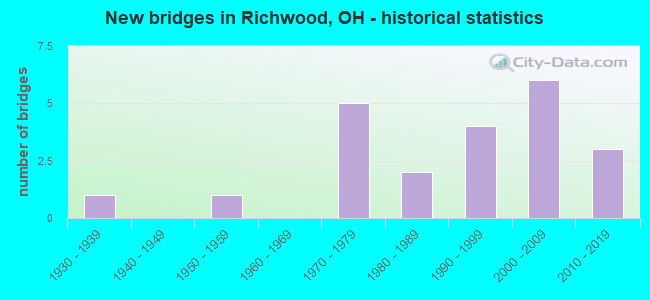
- New bridges - historical statistics
- 11930-1939
- 11950-1959
- 51970-1979
- 21980-1989
- 41990-1999
- 62000-2009
- 32010-2019

- Reconstructed bridges - Historical Statistics
- 11980-1989
- 21990-1999
- 12000-2009
- 12010-2019


- Bridge Condition - Deck
- 57.1%Excellent
- 9.5%Very good
- 14.3%Good
- 19.0%Satisfactory

- Bridge Condition - Superstructure
- 57.1%Excellent
- 9.5%Very good
- 19.0%Good
- 9.5%Satisfactory
- 4.8%Fair

- Bridge Condition - Substructure
- 42.9%Excellent
- 14.3%Very good
- 14.3%Good
- 14.3%Satisfactory
- 14.3%Fair

- Bridge Condition - Channel
- 27.3%Excellent
- 18.2%Very good
- 27.3%Good
- 27.3%Satisfactory
Find on map >> Show street view
Structure Number: 2132761, Location: 0.6 MI E OF UNION CO LINE (Lat: 40.407139, Lng: -83.239969), Route carried "on" structure: County highway C0182, Year Built: 1974, Year Reconstructed: 2014, Status: Open, Structure Length: 1.11m (3.64ft), Average Daily Traffic: 250 (year 2014), Truck Traffic: 5%, Average Future Daily Traffic: 347 (year 2034), Design Load: H 20, Features Intersected: OTTAWA CREEK, Facility Carried by Structure: TAWAY RD.
Minimum Vertical Clearance: 30+ m (98+ ft), Kilometerpoint: 0.885, Lanes on structure: 2, Owner: County Highway Agency, Approaching Roadway Width: 6.7m (22.0ft), Material/Design: Steel, Design/Construction: Stringer/Multi-beam, Number Of Spans In Main Unit: 1, Length of Maximum Span: 10.7m (35.1ft), Curb-To-Curb Width: 8.5m (27.9ft), Out-to-Out Width: 8.5m (27.9ft)
Condition: Deck: Excellent, Superstructure: Excellent, Substructure: Good, Channel: Satisfactory, Operating Rating: 58.3 metric tons, Method Used To Determine Operating Rating: Load Factor (LF) rating reported by rating factor (RF) method using MS18 loading, Inventory Rating: 35.6 metric tons, Method Used To Determine Inventory Rating: Load Factor (LF) rating reported by rating factor (RF) method using MS18 loading, Structural Evaluation: Better than present minimum criteria, Deck Geometry: Equal to present minimum criteria, Waterway Adequacy: Better than present minimum criteria, Approach Roadway Alignment: Equal to present desirable criteria, Length Of Structure Improvement: 1.11m (3.64ft), Designated Inspection Frequency: Every 24 months, Inspection Date: March 2021, Deck Structure Type: Concrete Cast-file-Place, Wearing Surface/Protective System: Wearing Surface: Monolithic Concrete
Find on map >> Show street view
Structure Number: 8000298, Location: 0.44 MI N. OF SR37 (Lat: 40.391461, Lng: -83.272919), Route carried "on" structure: State highway 4, Year Built: 1989, Status: Open, Structure Length: 4.51m (14.80ft), Average Daily Traffic: 7,544 (year 2015), Truck Traffic: 10%, Average Future Daily Traffic: 10,471 (year 2035), Design Load: HS 20+Mod, Features Intersected: FULTON CREEK
Minimum Vertical Clearance: 30+ m (98+ ft), Kilometerpoint: 38.624, Lanes on structure: 2, Base Highway Network: Yes, Owner: State Highway Agency, Approaching Roadway Width: 9.8m (32.2ft), Skew: 2 degrees, Material/Design: Prestressed concrete, Design/Construction: Box Beam or Girders - Multiple, Number Of Spans In Main Unit: 3, Length of Maximum Span: 15.2m (49.9ft), Curb-To-Curb Width: 12.2m (40.0ft), Out-to-Out Width: 12.2m (40.0ft)
Condition: Deck: Good, Superstructure: Good, Substructure: Very good, Channel: Excellent, Operating Rating: 51.8 metric tons, Method Used To Determine Operating Rating: Load and Resistance Factor Rating (LRFR) rating reported by rating factor(RF) method using HL-93 loadings, Inventory Rating: 32.4 metric tons, Method Used To Determine Inventory Rating: Load and Resistance Factor Rating (LRFR) rating reported by rating factor(RF) method using HL-93 loadings, Structural Evaluation: Better than present minimum criteria, Deck Geometry: Somewhat better than minimum adequacy, Waterway Adequacy: Equal to present desirable criteria, Approach Roadway Alignment: Equal to present desirable criteria, Designated Inspection Frequency: Every 24 months, Inspection Date: January 2021, Deck Structure Type: Concrete Cast-file-Place, Wearing Surface/Protective System: Wearing Surface: Bituminous, Membrane: Built-up
Find on map >> Show street view
Structure Number: 8000344, Location: 2.22 MI. N. OF SR37 (Lat: 40.413011, Lng: -83.254139), Route carried "on" structure: State highway 4, Year Built: 1970, Status: Open, Structure Length: 2.03m (6.66ft), Average Daily Traffic: 4,817 (year 2015), Truck Traffic: 14%, Average Future Daily Traffic: 6,686 (year 2035), Design Load: HS 20+Mod, Features Intersected: OTTAWA CREEK
Minimum Vertical Clearance: 30+ m (98+ ft), Kilometerpoint: 41.489, Lanes on structure: 2, Base Highway Network: Yes, Owner: State Highway Agency, Approaching Roadway Width: 13.4m (44.0ft), Material/Design: Concrete continuous, Design/Construction: Slab, Number Of Spans In Main Unit: 3, Length of Maximum Span: 7.6m (24.9ft), Curb-To-Curb Width: 13.4m (44.0ft), Out-to-Out Width: 13.4m (44.0ft)
Condition: Deck: Good, Superstructure: Good, Substructure: Satisfactory, Channel: Good, Operating Rating: 42.1 metric tons, Method Used To Determine Operating Rating: Load Factor (LF) rating reported by rating factor (RF) method using MS18 loading, Inventory Rating: 32.4 metric tons, Method Used To Determine Inventory Rating: Load Factor (LF) rating reported by rating factor (RF) method using MS18 loading, Structural Evaluation: Equal to present minimum criteria, Deck Geometry: Better than present minimum criteria, Waterway Adequacy: Equal to present desirable criteria, Approach Roadway Alignment: Equal to present desirable criteria, Designated Inspection Frequency: Every 12 months, Inspection Date: January 2022, Deck Structure Type: Concrete Cast-file-Place, Wearing Surface/Protective System: Wearing Surface: Integral Concrete
Find on map >> Show street view
Structure Number: 8001898, Location: 0.16 MI N OF SR739 (Lat: 40.482339, Lng: -83.317939), Route carried "on" structure: State highway 37, Year Built: 1955, Status: Open, Structure Length: 5.30m (17.39ft), Average Daily Traffic: 1,605 (year 2015), Truck Traffic: 3%, Average Future Daily Traffic: 2,228 (year 2035), Design Load: H 15, Features Intersected: RUSH CREEK
Minimum Vertical Clearance: 30+ m (98+ ft), Kilometerpoint: 3.283, Lanes on structure: 2, Owner: State Highway Agency, Approaching Roadway Width: 11.6m (38.1ft), Skew: 3 degrees, Material/Design: Concrete continuous, Design/Construction: Slab, Number Of Spans In Main Unit: 4, Length of Maximum Span: 14.6m (47.9ft), Curb-To-Curb Width: 11.0m (36.1ft), Out-to-Out Width: 11.0m (36.1ft)
Condition: Deck: Satisfactory, Superstructure: Fair, Substructure: Fair, Channel: Satisfactory, Operating Rating: 35.6 metric tons, Method Used To Determine Operating Rating: Load Factor (LF) rating reported by rating factor (RF) method using MS18 loading, Inventory Rating: 25.9 metric tons, Method Used To Determine Inventory Rating: Load Factor (LF) rating reported by rating factor (RF) method using MS18 loading, Structural Evaluation: Somewhat better than minimum adequacy, Deck Geometry: Equal to present minimum criteria, Waterway Adequacy: Equal to present desirable criteria, Approach Roadway Alignment: Equal to present desirable criteria, Designated Inspection Frequency: Every 12 months, Inspection Date: June 2021, Deck Structure Type: Concrete Cast-file-Place, Wearing Surface/Protective System: Wearing Surface: Latex Concrete
Find on map >> Show street view
Structure Number: 800265, Location: 2.8 miles east of RT 31 (Lat: 40.409600, Lng: -83.362900), Route carried "on" structure: State highway 47, Year Built: 2018, Status: Open, Structure Length: 2.64m (8.66ft), Average Daily Traffic: 1,200 (year 2017), Truck Traffic: 8%, Average Future Daily Traffic: 1,800 (year 2037), Design Load: HL 93, Features Intersected: Fulton Creek
Minimum Vertical Clearance: 30+ m (98+ ft), Kilometerpoint: 16.689, Lanes on structure: 2, Owner: State Highway Agency, Approaching Roadway Width: 9.8m (32.2ft), Material/Design: Steel, Design/Construction: Stringer/Multi-beam, Number Of Spans In Main Unit: 1, Length of Maximum Span: 25.8m (84.6ft), Curb-To-Curb Width: 11.0m (36.1ft), Out-to-Out Width: 11.0m (36.1ft)
Condition: Deck: Excellent, Superstructure: Excellent, Substructure: Excellent, Channel: Excellent, Operating Rating: 55.1 metric tons, Method Used To Determine Operating Rating: Load and Resistance Factor Rating (LRFR) rating reported by rating factor(RF) method using HL-93 loadings, Inventory Rating: 42.1 metric tons, Method Used To Determine Inventory Rating: Load and Resistance Factor Rating (LRFR) rating reported by rating factor(RF) method using HL-93 loadings, Structural Evaluation: Superior to present desirable criteria, Deck Geometry: Equal to present minimum criteria, Waterway Adequacy: Superior to present desirable criteria, Approach Roadway Alignment: Equal to present desirable criteria, Length Of Structure Improvement: 2.62m (8.60ft), Designated Inspection Frequency: Every 24 months, Inspection Date: June 2021, Deck Structure Type: Concrete Cast-file-Place, Wearing Surface/Protective System: Wearing Surface: Integral Concrete, Deck Protection: Epoxy Coated Reinforcing
Find on map >> Show street view
Structure Number: 8002681, Location: 01.7 MI E.OF SR37 (Lat: 40.434481, Lng: -83.266700), Route carried "on" structure: State highway 47, Year Built: 1996, Status: Open, Structure Length: 0.81m (2.66ft), Average Daily Traffic: 1,630 (year 2015), Truck Traffic: 5%, Average Future Daily Traffic: 2,262 (year 2035), Design Load: HS 20+Mod, Features Intersected: OTTAWA DITCH
Minimum Vertical Clearance: 30+ m (98+ ft), Kilometerpoint: 25.556, Lanes on structure: 2, Owner: State Highway Agency, Approaching Roadway Width: 12.2m (40.0ft), Material/Design: Concrete, Design/Construction: Culvert, Number Of Spans In Main Unit: 1, Length of Maximum Span: 7.6m (24.9ft)
Condition: Channel: Good, Culverts: Very good, Operating Rating: 42.1 metric tons, Method Used To Determine Operating Rating: Load Factor (LF) rating reported by rating factor (RF) method using MS18 loading, Inventory Rating: 32.4 metric tons, Method Used To Determine Inventory Rating: Load Factor (LF) rating reported by rating factor (RF) method using MS18 loading, Structural Evaluation: Equal to present desirable criteria, Waterway Adequacy: Superior to present desirable criteria, Approach Roadway Alignment: Equal to present minimum criteria, Designated Inspection Frequency: Every 24 months, Inspection Date: September 2021, Wearing Surface/Protective System: Membrane: Preformed Fabric
Find on map >> Show street view
Structure Number: 8031436, Location: 1 MI. WEST OF SR 4 (Lat: 40.424531, Lng: -83.275531), Route carried "on" structure: County highway C0265, Year Built: 1997, Status: Open, Structure Length: 0.98m (3.22ft), Average Daily Traffic: 523 (year 2015), Truck Traffic: 7%, Average Future Daily Traffic: 726 (year 2035), Design Load: HS 20, Features Intersected: OTTAWA CREEK, Facility Carried by Structure: C265A HOSKINS RD
Minimum Vertical Clearance: 30+ m (98+ ft), Kilometerpoint: 2.943, Lanes on structure: 2, Owner: County Highway Agency, Approaching Roadway Width: 6.7m (22.0ft), Material/Design: Prestressed concrete, Design/Construction: Box Beam or Girders - Multiple, Number Of Spans In Main Unit: 1, Length of Maximum Span: 9.4m (30.8ft), Curb-To-Curb Width: 8.5m (27.9ft), Out-to-Out Width: 8.5m (27.9ft)
Condition: Deck: Good, Superstructure: Good, Substructure: Very good, Channel: Excellent, Operating Rating: 42.1 metric tons, Method Used To Determine Operating Rating: Load Factor (LF) rating reported by rating factor (RF) method using MS18 loading, Inventory Rating: 32.4 metric tons, Method Used To Determine Inventory Rating: Load Factor (LF) rating reported by rating factor (RF) method using MS18 loading, Structural Evaluation: Better than present minimum criteria, Deck Geometry: Somewhat better than minimum adequacy, Waterway Adequacy: Better than present minimum criteria, Approach Roadway Alignment: Equal to present minimum criteria, Designated Inspection Frequency: Every 24 months, Inspection Date: July 2021, Deck Structure Type: Concrete Cast-file-Place, Wearing Surface/Protective System: Wearing Surface: Bituminous, Membrane: Preformed Fabric
Find on map >> Show street view
Structure Number: 8034087, Location: 1 MI NORTH OF MULVANE RD (Lat: 40.450089, Lng: -83.319031), Route carried "on" structure: County highway C0175, Year Built: 1930, Year Reconstructed: 1989, Status: Open, Structure Length: 0.85m (2.79ft), Average Daily Traffic: 342 (year 2015), Truck Traffic: 8%, Average Future Daily Traffic: 475 (year 2035), Design Load: HS 20+Mod, Features Intersected: BRANCH RUSH CREEK, Facility Carried by Structure: C175 LE MASTERS RD
Minimum Vertical Clearance: 30+ m (98+ ft), Kilometerpoint: 1.587, Lanes on structure: 2, Owner: County Highway Agency, Approaching Roadway Width: 5.5m (18.0ft), Material/Design: Prestressed concrete, Design/Construction: Box Beam or Girders - Multiple, Number Of Spans In Main Unit: 1, Length of Maximum Span: 7.6m (24.9ft), Curb-To-Curb Width: 8.5m (27.9ft), Out-to-Out Width: 8.5m (27.9ft)
Condition: Deck: Very good, Superstructure: Very good, Substructure: Fair, Channel: Satisfactory, Operating Rating: 42.1 metric tons, Method Used To Determine Operating Rating: Load Factor (LF) rating reported by rating factor (RF) method using MS18 loading, Inventory Rating: 32.4 metric tons, Method Used To Determine Inventory Rating: Load Factor (LF) rating reported by rating factor (RF) method using MS18 loading, Structural Evaluation: Somewhat better than minimum adequacy, Deck Geometry: Equal to present minimum criteria, Waterway Adequacy: Equal to present desirable criteria, Approach Roadway Alignment: Equal to present desirable criteria, Designated Inspection Frequency: Every 12 months, Inspection Date: July 2021, Deck Structure Type: Concrete Cast-file-Place, Wearing Surface/Protective System: Wearing Surface: Bituminous, Membrane: Preformed Fabric
Find on map >> Show street view
Structure Number: 8035512, Location: .75 MI. WEST OF SR37 (Lat: 40.456750, Lng: -83.317131), Route carried "on" structure: County highway C0286, Year Built: 2004, Status: Open, Structure Length: 1.28m (4.20ft), Average Daily Traffic: 75 (year 2015), Truck Traffic: 8%, Average Future Daily Traffic: 104 (year 2035), Design Load: HS 20+Mod, Features Intersected: BRANCH OF RUSH CREEK, Facility Carried by Structure: CR286L BOUNDARY RD
Minimum Vertical Clearance: 30+ m (98+ ft), Kilometerpoint: 8.401, Lanes on structure: 2, Owner: County Highway Agency, Approaching Roadway Width: 3.0m (9.8ft), Material/Design: Prestressed concrete, Design/Construction: Box Beam or Girders - Multiple, Number Of Spans In Main Unit: 1, Length of Maximum Span: 12.2m (40.0ft), Curb-To-Curb Width: 9.1m (29.9ft), Out-to-Out Width: 9.1m (29.9ft)
Condition: Deck: Excellent, Superstructure: Excellent, Substructure: Excellent, Channel: Very good, Operating Rating: 42.1 metric tons, Method Used To Determine Operating Rating: Load Factor (LF) rating reported by rating factor (RF) method using MS18 loading, Inventory Rating: 32.4 metric tons, Method Used To Determine Inventory Rating: Load Factor (LF) rating reported by rating factor (RF) method using MS18 loading, Structural Evaluation: Equal to present desirable criteria, Deck Geometry: Better than present minimum criteria, Waterway Adequacy: Equal to present desirable criteria, Approach Roadway Alignment: Equal to present desirable criteria, Designated Inspection Frequency: Every 24 months, Inspection Date: July 2021, Deck Structure Type: Concrete Cast-file-Place, Wearing Surface/Protective System: Wearing Surface: Bituminous, Membrane: Preformed Fabric
Find on map >> Show street view
Structure Number: 8035556, Location: 1.7 MI SOUTH of SR 47 (Lat: 40.400931, Lng: -83.306600), Route carried "on" structure: County highway C0262, Year Built: 2014, Status: Open, Structure Length: 1.31m (4.30ft), Average Daily Traffic: 295 (year 2015), Truck Traffic: 7%, Average Future Daily Traffic: 409 (year 2035), Design Load: HL 93, Features Intersected: BRANCH FULTON CREEEK, Facility Carried by Structure: C262E KINNEY PIKE
Minimum Vertical Clearance: 30+ m (98+ ft), Kilometerpoint: 6.534, Lanes on structure: 2, Owner: County Highway Agency, Approaching Roadway Width: 7.9m (25.9ft), Material/Design: Prestressed concrete, Design/Construction: Box Beam or Girders - Multiple, Number Of Spans In Main Unit: 1, Length of Maximum Span: 12.5m (41.0ft), Curb-To-Curb Width: 7.9m (25.9ft), Out-to-Out Width: 8.5m (27.9ft)
Condition: Deck: Excellent, Superstructure: Excellent, Substructure: Excellent, Channel: Satisfactory, Operating Rating: 58.3 metric tons, Method Used To Determine Operating Rating: Load and Resistance Factor Rating (LRFR) rating reported by rating factor(RF) method using HL-93 loadings, Inventory Rating: 45.4 metric tons, Method Used To Determine Inventory Rating: Load and Resistance Factor Rating (LRFR) rating reported by rating factor(RF) method using HL-93 loadings, Structural Evaluation: Superior to present desirable criteria, Deck Geometry: Somewhat better than minimum adequacy, Waterway Adequacy: Better than present minimum criteria, Approach Roadway Alignment: Equal to present desirable criteria, Length Of Structure Improvement: 1.31m (4.30ft), Designated Inspection Frequency: Every 24 months, Inspection Date: August 2021, Deck Structure Type: Concrete Cast-file-Place, Wearing Surface/Protective System: Wearing Surface: Bituminous, Membrane: Epoxy, Deck Protection: Epoxy Coated Reinforcing
Find on map >> Show street view
Structure Number: 8035652, Location: 1.5 MI. N OF CR 200 (Lat: 40.412981, Lng: -83.310311), Route carried "on" structure: County highway C0262, Year Built: 1990, Status: Open, Structure Length: 3.35m (10.99ft), Average Daily Traffic: 295 (year 2015), Truck Traffic: 7%, Average Future Daily Traffic: 409 (year 2035), Design Load: HS 20+Mod, Features Intersected: FULTON CREEK, Facility Carried by Structure: C262F KINNEY PIKE
Minimum Vertical Clearance: 30+ m (98+ ft), Kilometerpoint: 7.907, Lanes on structure: 2, Owner: County Highway Agency, Approaching Roadway Width: 8.5m (27.9ft), Material/Design: Prestressed concrete, Design/Construction: Box Beam or Girders - Multiple, Number Of Spans In Main Unit: 3, Length of Maximum Span: 10.7m (35.1ft), Curb-To-Curb Width: 8.5m (27.9ft), Out-to-Out Width: 8.5m (27.9ft)
Condition: Deck: Very good, Superstructure: Very good, Substructure: Satisfactory, Channel: Very good, Operating Rating: 42.1 metric tons, Method Used To Determine Operating Rating: Load Factor (LF) rating reported by rating factor (RF) method using MS18 loading, Inventory Rating: 32.4 metric tons, Method Used To Determine Inventory Rating: Load Factor (LF) rating reported by rating factor (RF) method using MS18 loading, Structural Evaluation: Equal to present minimum criteria, Deck Geometry: Equal to present minimum criteria, Waterway Adequacy: Superior to present desirable criteria, Approach Roadway Alignment: Equal to present desirable criteria, Designated Inspection Frequency: Every 12 months, Inspection Date: August 2021, Deck Structure Type: Concrete Cast-file-Place, Wearing Surface/Protective System: Wearing Surface: Bituminous
Find on map >> Show street view
Structure Number: 8035725, Location: 0.75 MI WEST of SR 4 (Lat: 40.416611, Lng: -83.261500), Route carried "on" structure: County highway C0264, Year Built: 1971, Year Reconstructed: 1998, Status: Open, Structure Length: 0.82m (2.69ft), Average Daily Traffic: 285 (year 2015), Truck Traffic: 8%, Average Future Daily Traffic: 396 (year 2035), Design Load: HS 20, Features Intersected: OTTAWA CREEK, Facility Carried by Structure: CR 264 A TAWA RD
Minimum Vertical Clearance: 30+ m (98+ ft), Kilometerpoint: 2.715, Lanes on structure: 2, Owner: County Highway Agency, Approaching Roadway Width: 4.9m (16.1ft), Material/Design: Prestressed concrete, Design/Construction: Box Beam or Girders - Multiple, Number Of Spans In Main Unit: 1, Length of Maximum Span: 7.9m (25.9ft), Curb-To-Curb Width: 7.6m (24.9ft), Out-to-Out Width: 7.6m (24.9ft)
Condition: Deck: Satisfactory, Superstructure: Good, Substructure: Satisfactory, Channel: Good, Operating Rating: 74.5 metric tons, Method Used To Determine Operating Rating: Load Factor (LF) rating reported by rating factor (RF) method using MS18 loading, Inventory Rating: 45.4 metric tons, Method Used To Determine Inventory Rating: Load Factor (LF) rating reported by rating factor (RF) method using MS18 loading, Structural Evaluation: Equal to present minimum criteria, Deck Geometry: Somewhat better than minimum adequacy, Waterway Adequacy: Equal to present minimum criteria, Approach Roadway Alignment: Equal to present minimum criteria, Designated Inspection Frequency: Every 12 months, Inspection Date: July 2021, Deck Structure Type: Concrete Cast-file-Place, Wearing Surface/Protective System: Wearing Surface: Bituminous
Find on map >> Show street view
Structure Number: 8035814, Location: 0.3 MI WEST of SR 4 (Lat: 40.413131, Lng: -83.257439), Route carried "on" structure: County highway C0264, Year Built: 2006, Status: Open, Structure Length: 1.52m (4.99ft), Average Daily Traffic: 285 (year 2015), Truck Traffic: 8%, Average Future Daily Traffic: 396 (year 2035), Design Load: HS 20+Mod, Features Intersected: OTTAWA DITCH, Facility Carried by Structure: CR 264 A TAWA RD
Minimum Vertical Clearance: 30+ m (98+ ft), Kilometerpoint: 3.235, Lanes on structure: 2, Owner: County Highway Agency, Approaching Roadway Width: 5.2m (17.1ft), Material/Design: Prestressed concrete, Design/Construction: Box Beam or Girders - Multiple, Number Of Spans In Main Unit: 1, Length of Maximum Span: 14.0m (45.9ft), Curb-To-Curb Width: 9.8m (32.2ft), Out-to-Out Width: 9.8m (32.2ft)
Condition: Deck: Excellent, Superstructure: Excellent, Substructure: Very good, Channel: Excellent, Operating Rating: 42.1 metric tons, Method Used To Determine Operating Rating: Load Factor (LF) rating reported by rating factor (RF) method using MS18 loading, Inventory Rating: 32.4 metric tons, Method Used To Determine Inventory Rating: Load Factor (LF) rating reported by rating factor (RF) method using MS18 loading, Structural Evaluation: Equal to present desirable criteria, Deck Geometry: Better than present minimum criteria, Waterway Adequacy: Superior to present desirable criteria, Approach Roadway Alignment: Equal to present desirable criteria, Designated Inspection Frequency: Every 24 months, Inspection Date: July 2021, Deck Structure Type: Concrete Cast-file-Place, Wearing Surface/Protective System: Wearing Surface: Bituminous, Membrane: Preformed Fabric
Find on map >> Show street view
Structure Number: 8035989, Location: 1 MI SOUTH of BOUNDARY RD (Lat: 40.452361, Lng: -83.249711), Route carried "on" structure: County highway T0267, Year Built: 1982, Year Reconstructed: 2019, Status: Open, Structure Length: 0.98m (3.22ft), Average Daily Traffic: 496 (year 2015), Truck Traffic: 7%, Average Future Daily Traffic: 688 (year 2035), Design Load: HS 20, Features Intersected: PATTON RUN, Facility Carried by Structure: T267B SCHOFIELD RD
Minimum Vertical Clearance: 30+ m (98+ ft), Kilometerpoint: 1.553, Lanes on structure: 2, Owner: County Highway Agency, Approaching Roadway Width: 6.1m (20.0ft), Material/Design: Prestressed concrete, Design/Construction: Box Beam or Girders - Multiple, Number Of Spans In Main Unit: 1, Length of Maximum Span: 9.1m (29.9ft), Curb-To-Curb Width: 8.5m (27.9ft), Out-to-Out Width: 8.5m (27.9ft)
Condition: Deck: Excellent, Superstructure: Excellent, Substructure: Good, Channel: Satisfactory, Operating Rating: 42.1 metric tons, Method Used To Determine Operating Rating: Load Factor (LF) rating reported by rating factor (RF) method using MS18 loading, Inventory Rating: 32.4 metric tons, Method Used To Determine Inventory Rating: Load Factor (LF) rating reported by rating factor (RF) method using MS18 loading, Structural Evaluation: Better than present minimum criteria, Deck Geometry: Somewhat better than minimum adequacy, Waterway Adequacy: Equal to present desirable criteria, Approach Roadway Alignment: Equal to present desirable criteria, Length Of Structure Improvement: 0.98m (3.22ft), Designated Inspection Frequency: Every 12 months, Inspection Date: July 2021, Bridge Improvement Cost: $81,000,000, Total Project Cost: $81,000,000, Deck Structure Type: Concrete Cast-file-Place, Wearing Surface/Protective System: Wearing Surface: Bituminous
Find on map >> Show street view
Structure Number: 8036128, Location: 0.3 MI. S. OF SR 739 (Lat: 40.476761, Lng: -83.328600), Route carried "on" structure: County highway C0275, Year Built: 1993, Status: Open, Structure Length: 3.08m (10.10ft), Average Daily Traffic: 658 (year 2015), Truck Traffic: 7%, Average Future Daily Traffic: 913 (year 2035), Design Load: HS 20, Features Intersected: RUSH CREEK, Facility Carried by Structure: CR275C HAMILTON RD
Minimum Vertical Clearance: 30+ m (98+ ft), Kilometerpoint: 2.330, Lanes on structure: 2, Owner: County Highway Agency, Approaching Roadway Width: 7.3m (24.0ft), Material/Design: Prestressed concrete continuous, Design/Construction: Box Beam or Girders - Multiple, Number Of Spans In Main Unit: 2, Length of Maximum Span: 15.2m (49.9ft), Curb-To-Curb Width: 7.3m (24.0ft), Out-to-Out Width: 7.3m (24.0ft)
Condition: Deck: Excellent, Superstructure: Excellent, Substructure: Excellent, Channel: Good, Operating Rating: 42.1 metric tons, Method Used To Determine Operating Rating: Load Factor (LF) rating reported by rating factor (RF) method using MS18 loading, Inventory Rating: 32.4 metric tons, Method Used To Determine Inventory Rating: Load Factor (LF) rating reported by rating factor (RF) method using MS18 loading, Structural Evaluation: Equal to present desirable criteria, Deck Geometry: Meets minimum limits, Waterway Adequacy: Equal to present desirable criteria, Approach Roadway Alignment: Equal to present desirable criteria, Designated Inspection Frequency: Every 24 months, Inspection Date: July 2021, Deck Structure Type: Concrete Cast-file-Place, Wearing Surface/Protective System: Wearing Surface: Bituminous, Membrane: Preformed Fabric
Find on map >> Show street view
Structure Number: 8036306, Location: 1MI S of SR47 (Lat: 40.403611, Lng: -83.343789), Route carried "on" structure: County highway C0280, Year Built: 2000, Status: Open, Structure Length: 2.77m (9.09ft), Average Daily Traffic: 347 (year 2015), Truck Traffic: 7%, Average Future Daily Traffic: 482 (year 2035), Design Load: HS 20+Mod, Features Intersected: FULTON CREEK, Facility Carried by Structure: CR280B ZOOK RD
Minimum Vertical Clearance: 30+ m (98+ ft), Kilometerpoint: 2.482, Lanes on structure: 2, Owner: County Highway Agency, Approaching Roadway Width: 5.5m (18.0ft), Skew: 2 degrees, Material/Design: Steel, Design/Construction: Truss - Thru, Number Of Spans In Main Unit: 1, Length of Maximum Span: 27.4m (89.9ft), Curb-To-Curb Width: 7.3m (24.0ft), Out-to-Out Width: 7.6m (24.9ft)
Condition: Deck: Excellent, Superstructure: Excellent, Substructure: Excellent, Channel: Very good, Operating Rating: 58.3 metric tons, Method Used To Determine Operating Rating: Allowable Stress (AS) rating reported by rating factor (RF) method using MS18 loading, Inventory Rating: 35.6 metric tons, Method Used To Determine Inventory Rating: Allowable Stress (AS) rating reported by rating factor (RF) method using MS18 loading, Structural Evaluation: Superior to present desirable criteria, Deck Geometry: Somewhat better than minimum adequacy, Waterway Adequacy: Superior to present desirable criteria, Approach Roadway Alignment: Equal to present desirable criteria, Designated Inspection Frequency: Every 12 months, Critical Feature Inspection Frequency: Every 24 months, Inspection Date: August 2021, Critical Feature Inspection Date: July 2020, Deck Structure Type: Wood or Timber, Wearing Surface/Protective System: Wearing Surface: Bituminous, Membrane: Preformed Fabric
Find on map >> Show street view
Structure Number: 8036535, Location: 2.25 MI EAST OF SR37 (Lat: 40.462300, Lng: -83.259531), Route carried "on" structure: County highway C0286, Year Built: 2003, Status: Open, Structure Length: 1.19m (3.90ft), Average Daily Traffic: 693 (year 2015), Truck Traffic: 7%, Average Future Daily Traffic: 962 (year 2035), Design Load: HS 20+Mod, Features Intersected: LANDON PATTON RUN, Facility Carried by Structure: C286O BOUNDARY RD
Minimum Vertical Clearance: 30+ m (98+ ft), Kilometerpoint: 13.309, Lanes on structure: 2, Owner: County Highway Agency, Approaching Roadway Width: 6.1m (20.0ft), Material/Design: Prestressed concrete, Design/Construction: Box Beam or Girders - Multiple, Number Of Spans In Main Unit: 1, Length of Maximum Span: 10.7m (35.1ft), Curb-To-Curb Width: 9.8m (32.2ft), Out-to-Out Width: 9.8m (32.2ft)
Condition: Deck: Excellent, Superstructure: Excellent, Substructure: Excellent, Channel: Satisfactory, Operating Rating: 42.1 metric tons, Method Used To Determine Operating Rating: Load Factor (LF) rating reported by rating factor (RF) method using MS18 loading, Inventory Rating: 32.4 metric tons, Method Used To Determine Inventory Rating: Load Factor (LF) rating reported by rating factor (RF) method using MS18 loading, Structural Evaluation: Equal to present desirable criteria, Deck Geometry: Equal to present minimum criteria, Waterway Adequacy: Equal to present desirable criteria, Approach Roadway Alignment: Equal to present desirable criteria, Designated Inspection Frequency: Every 24 months, Inspection Date: July 2021, Deck Structure Type: Concrete Cast-file-Place, Wearing Surface/Protective System: Wearing Surface: Bituminous, Membrane: Preformed Fabric
Find on map >> Show street view
Structure Number: 8037094, Location: 1 MI NORTH of CR 200 (Lat: 40.402500, Lng: -83.327781), Route carried "on" structure: County highway T0279, Year Built: 2011, Status: Open, Structure Length: 3.72m (12.20ft), Average Daily Traffic: 89 (year 2015), Truck Traffic: 8%, Average Future Daily Traffic: 124 (year 2035), Design Load: HL 93, Features Intersected: FULTON CREEK, Facility Carried by Structure: TR279 SNEDIKER RD
Minimum Vertical Clearance: 30+ m (98+ ft), Kilometerpoint: 1.674, Lanes on structure: 2, Owner: County Highway Agency, Approaching Roadway Width: 4.9m (16.1ft), Skew: 1 degrees, Material/Design: Prestressed concrete continuous, Design/Construction: Box Beam or Girders - Multiple, Number Of Spans In Main Unit: 3, Length of Maximum Span: 14.0m (45.9ft), Curb-To-Curb Width: 7.9m (25.9ft), Out-to-Out Width: 7.9m (25.9ft)
Condition: Deck: Excellent, Superstructure: Excellent, Substructure: Excellent, Channel: Excellent, Operating Rating: 45.4 metric tons, Method Used To Determine Operating Rating: Load and Resistance Factor Rating (LRFR) rating reported by rating factor(RF) method using HL-93 loadings, Inventory Rating: 35.6 metric tons, Method Used To Determine Inventory Rating: Load and Resistance Factor Rating (LRFR) rating reported by rating factor(RF) method using HL-93 loadings, Structural Evaluation: Superior to present desirable criteria, Deck Geometry: Equal to present minimum criteria, Waterway Adequacy: Superior to present desirable criteria, Approach Roadway Alignment: Equal to present desirable criteria, Designated Inspection Frequency: Every 24 months, Inspection Date: August 2021, Deck Structure Type: Concrete Cast-file-Place, Wearing Surface/Protective System: Wearing Surface: Integral Concrete, Membrane: Epoxy, Deck Protection: Epoxy Coated Reinforcing
Find on map >> Show street view
Structure Number: 8037221, Location: 0.03 MI EAST of SR 37 (Lat: 40.494019, Lng: -83.322231), Route carried "on" structure: County highway C0322, Year Built: 1970, Status: Open, Structure Length: 4.69m (15.39ft), Average Daily Traffic: 407 (year 2015), Truck Traffic: 8%, Average Future Daily Traffic: 565 (year 2035), Design Load: HS 20, Features Intersected: RUSH CREEK, Facility Carried by Structure: CR322A SANDERS RD
Minimum Vertical Clearance: 30+ m (98+ ft), Kilometerpoint: 0.048, Lanes on structure: 2, Owner: County Highway Agency, Approaching Roadway Width: 8.5m (27.9ft), Material/Design: Prestressed concrete, Design/Construction: Box Beam or Girders - Multiple, Number Of Spans In Main Unit: 3, Length of Maximum Span: 15.9m (52.2ft), Curb-To-Curb Width: 8.6m (28.2ft), Out-to-Out Width: 8.6m (28.2ft)
Condition: Deck: Satisfactory, Superstructure: Satisfactory, Substructure: Fair, Channel: Good, Operating Rating: 81.0 metric tons, Method Used To Determine Operating Rating: Load Factor (LF) rating reported by rating factor (RF) method using MS18 loading, Inventory Rating: 77.8 metric tons, Method Used To Determine Inventory Rating: Load Factor (LF) rating reported by rating factor (RF) method using MS18 loading, Structural Evaluation: Somewhat better than minimum adequacy, Deck Geometry: Somewhat better than minimum adequacy, Waterway Adequacy: Equal to present minimum criteria, Approach Roadway Alignment: Equal to present minimum criteria, Designated Inspection Frequency: Every 12 months, Inspection Date: July 2021, Deck Structure Type: Concrete Cast-file-Place, Wearing Surface/Protective System: Wearing Surface: Bituminous
Find on map >> Show street view
Structure Number: 8037264, Location: 0.3 MI WEST of SR 37 (Lat: 40.465469, Lng: -83.312969), Route carried "on" structure: County highway C0325, Year Built: 2005, Status: Open, Structure Length: 1.62m (5.31ft), Average Daily Traffic: 62 (year 2015), Truck Traffic: 8%, Average Future Daily Traffic: 86 (year 2035), Design Load: HS 20+Mod, Features Intersected: MARROITT DITCH, Facility Carried by Structure: CR325 SWARTZ RD
Minimum Vertical Clearance: 30+ m (98+ ft), Kilometerpoint: 1.127, Lanes on structure: 2, Owner: County Highway Agency, Approaching Roadway Width: 4.6m (15.1ft), Material/Design: Prestressed concrete, Design/Construction: Box Beam or Girders - Multiple, Number Of Spans In Main Unit: 1, Length of Maximum Span: 15.5m (50.9ft), Curb-To-Curb Width: 8.5m (27.9ft), Out-to-Out Width: 8.5m (27.9ft)
Condition: Deck: Excellent, Superstructure: Excellent, Substructure: Excellent, Channel: Very good, Operating Rating: 42.1 metric tons, Method Used To Determine Operating Rating: Load Factor (LF) rating reported by rating factor (RF) method using MS18 loading, Inventory Rating: 32.4 metric tons, Method Used To Determine Inventory Rating: Load Factor (LF) rating reported by rating factor (RF) method using MS18 loading, Structural Evaluation: Equal to present desirable criteria, Deck Geometry: Better than present minimum criteria, Waterway Adequacy: Equal to present desirable criteria, Approach Roadway Alignment: Equal to present desirable criteria, Designated Inspection Frequency: Every 24 months, Inspection Date: July 2021, Deck Structure Type: Concrete Cast-file-Place, Wearing Surface/Protective System: Wearing Surface: Bituminous, Membrane: Preformed Fabric
Find on map >> Show street view
Structure Number: 8038414, Location: 0.13 MI WEST of SR 37 (Lat: 40.395300, Lng: -83.284161), Route carried "on" structure: County highway C0200, Year Built: 1971, Year Reconstructed: 1998, Status: Open, Structure Length: 3.11m (10.20ft), Average Daily Traffic: 253 (year 2015), Truck Traffic: 8%, Average Future Daily Traffic: 351 (year 2035), Design Load: HS 15, Features Intersected: FULTON CREEK, Facility Carried by Structure: C200D BEHLEHM-CLAI
Minimum Vertical Clearance: 30+ m (98+ ft), Kilometerpoint: 5.629, Lanes on structure: 2, Owner: County Highway Agency, Approaching Roadway Width: 8.5m (27.9ft), Material/Design: Concrete continuous, Design/Construction: Slab, Number Of Spans In Main Unit: 3, Length of Maximum Span: 11.6m (38.1ft), Curb-To-Curb Width: 8.5m (27.9ft), Out-to-Out Width: 8.5m (27.9ft)
Condition: Deck: Satisfactory, Superstructure: Satisfactory, Substructure: Good, Channel: Good, Operating Rating: 29.2 metric tons, Method Used To Determine Operating Rating: Load Factor (LF) rating reported by rating factor (RF) method using MS18 loading, Inventory Rating: 19.4 metric tons, Method Used To Determine Inventory Rating: Load Factor (LF) rating reported by rating factor (RF) method using MS18 loading, Structural Evaluation: Somewhat better than minimum adequacy, Deck Geometry: Equal to present minimum criteria, Waterway Adequacy: Equal to present desirable criteria, Approach Roadway Alignment: Meets minimum limits, Designated Inspection Frequency: Every 12 months, Inspection Date: August 2021, Deck Structure Type: Concrete Cast-file-Place, Wearing Surface/Protective System: Wearing Surface: Integral Concrete
Find on map >> Show street view
Structure Number: 8055955, Location: 0.6 MI SOUTH of SR 47 (Lat: 40.404400, Lng: -83.353881), Route carried "on" structure: County highway C0129, Year Built: 2002, Status: Open, Structure Length: 3.23m (10.60ft), Average Daily Traffic: 153 (year 2015), Truck Traffic: 7%, Average Future Daily Traffic: 212 (year 2035), Design Load: HS 25 or greater, Features Intersected: FULTON CREEK, Facility Carried by Structure: C129L CLAIBOURNE
Minimum Vertical Clearance: 30+ m (98+ ft), Kilometerpoint: 13.932, Lanes on structure: 2, Owner: County Highway Agency, Approaching Roadway Width: 9.1m (29.9ft), Skew: 2 degrees, Material/Design: Concrete continuous, Design/Construction: Slab, Number Of Spans In Main Unit: 3, Length of Maximum Span: 12.2m (40.0ft), Curb-To-Curb Width: 9.1m (29.9ft), Out-to-Out Width: 9.1m (29.9ft)
Condition: Deck: Excellent, Superstructure: Excellent, Substructure: Excellent, Channel: Excellent, Operating Rating: 42.1 metric tons, Method Used To Determine Operating Rating: Load Factor (LF) rating reported by rating factor (RF) method using MS18 loading, Inventory Rating: 32.4 metric tons, Method Used To Determine Inventory Rating: Load Factor (LF) rating reported by rating factor (RF) method using MS18 loading, Structural Evaluation: Equal to present desirable criteria, Deck Geometry: Equal to present minimum criteria, Waterway Adequacy: Equal to present desirable criteria, Approach Roadway Alignment: Equal to present desirable criteria, Designated Inspection Frequency: Every 24 months, Inspection Date: August 2021, Deck Structure Type: Concrete Cast-file-Place, Wearing Surface/Protective System: Wearing Surface: Integral Concrete, Membrane: Epoxy, Deck Protection: Epoxy Coated Reinforcing