Bridge Statistics for Ridgeland, Mississippi (MS)
Condition, Traffic, Stress, Structural Evaluation, Project Costs
- National Bridge Inventory (NBI) Statistics
- 49Number of bridges
- 614ft / 187mTotal length
- $1,344,295,000Total costs
- 1,092,380Total average daily traffic
- 101,852Total average daily truck traffic
- National Bridge Inventory (NBI) Registered Bridges for Ridgeland
- No street view available for this location
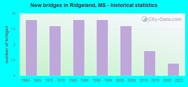
- New bridges - historical statistics
- 91960-1969
- 81970-1979
- 91980-1989
- 91990-1999
- 82000-2009
- 42010-2019
- 22020-2022


- Bridge Condition - Deck
- 18.5%Very good
- 48.1%Good
- 22.2%Satisfactory
- 11.1%Fair

- Bridge Condition - Superstructure
- 25.9%Very good
- 44.4%Good
- 25.9%Satisfactory
- 3.7%Fair

- Bridge Condition - Substructure
- 25.9%Very good
- 59.3%Good
- 11.1%Satisfactory
- 3.7%Fair

- Bridge Condition - Channel
- 26.7%Very good
- 26.7%Good
- 26.7%Satisfactory
- 13.3%Fair
- 6.7%Poor

- Bridge Condition - Culverts
- 50.0%Very good
- 33.3%Good
- 16.7%Fair
Find on map >> Show street view
Structure Number: 11000550451026B, Location: 0.3 MI N HINDS CL (Lat: 32.404769, Lng: -90.145639), Route carried "on" structure: Interstate 55, Year Built: 1985, Status: Open, Structure Length: 14.48m (47.51ft), Average Daily Traffic: 58,500 (year 2020), Truck Traffic: 4%, Average Future Daily Traffic: 68,500 (year 2040), Design Load: HS 20, Features Intersected: US 51 & CNIC RR
Minimum Vertical Clearance: 30+ m (98+ ft), Kilometerpoint: 0.562, Lanes on structure: 3, Lanes under structure: 4, Base Highway Network: Yes (Inventory Route: 5, Subroute: 1), Owner: State Highway Agency, Approaching Roadway Width: 17.1m (56.1ft), Skew: 4 degrees, Material/Design: Prestressed concrete, Design/Construction: Stringer/Multi-beam, Number Of Spans In Main Unit: 7, Length of Maximum Span: 21.3m (69.9ft), Curb-To-Curb Width: 18.1m (59.4ft), Out-to-Out Width: 18.9m (62.0ft)
Condition: Deck: Fair, Superstructure: Very good, Substructure: Good, Operating Rating: 57.1 metric tons, Method Used To Determine Operating Rating: Load Factor (LF), Inventory Rating: 23.2 metric tons, Method Used To Determine Inventory Rating: Load Factor (LF), Structural Evaluation: Somewhat better than minimum adequacy, Deck Geometry: Better than present minimum criteria, Underclear: Equal to present minimum criteria, Approach Roadway Alignment: Equal to present desirable criteria, Designated Inspection Frequency: Every 24 months, Inspection Date: April 2020, Deck Structure Type: Concrete Cast-file-Place
Find on map >> Show street view
Structure Number: 11000550451031A, Location: 0.8 MI N HINDS CL (Lat: 32.413219, Lng: -90.148431), Route carried "on" structure: Interstate 55, Year Built: 1979, Status: Open, Structure Length: 11.40m (37.40ft), Average Daily Traffic: 58,500 (year 2020), Truck Traffic: 4%, Average Future Daily Traffic: 68,500 (year 2040), Design Load: HS 20+Mod, Features Intersected: I 220E TO I 55 NORTH
Minimum Vertical Clearance: 5.40m (17.72ft), Kilometerpoint: 38.159, Lanes on structure: 3, Lanes under structure: 2, Base Highway Network: Yes (Inventory Route: 5, Subroute: 1), Owner: State Highway Agency, Approaching Roadway Width: 16.8m (55.1ft), Skew: 3 degrees, Material/Design: Concrete continuous, Design/Construction: Box Beam or Girders - Single/Spread, Number Of Spans In Main Unit: 5, Length of Maximum Span: 27.4m (89.9ft), Curb-To-Curb Width: 16.8m (55.1ft), Out-to-Out Width: 17.2m (56.4ft)
Condition: Deck: Fair, Superstructure: Fair, Substructure: Very good, Operating Rating: 75.2 metric tons, Method Used To Determine Operating Rating: Load Factor (LF), Inventory Rating: 45.4 metric tons, Method Used To Determine Inventory Rating: Load Factor (LF), Structural Evaluation: Somewhat better than minimum adequacy, Deck Geometry: Equal to present minimum criteria, Underclear: Superior to present desirable criteria, Approach Roadway Alignment: Equal to present desirable criteria, Length Of Structure Improvement: 14.41m (47.28ft), Designated Inspection Frequency: Every 24 months, Inspection Date: April 2020, Bridge Improvement Cost: $999,999,000, Roadway Improvement Cost: $183,000,000, Total Project Cost: $999,999,000, Deck Structure Type: Concrete Cast-file-Place
Find on map >> Show street view
Structure Number: 11000550451038, Location: 0.6 MI N I 220 (Lat: 32.421050, Lng: -90.144975), Route carried "on" structure: Interstate 55, Year Built: 1979, Status: Open, Structure Length: 1.10m (3.61ft), Average Daily Traffic: 120,000 (year 2020), Truck Traffic: 5%, Average Future Daily Traffic: 140,000 (year 2040), Design Load: HS 20, Features Intersected: PURPLE CREEK
Minimum Vertical Clearance: 30+ m (98+ ft), Kilometerpoint: 2.454, Lanes on structure: 10, Base Highway Network: Yes (Inventory Route: 5, Subroute: 1), Owner: State Highway Agency, Approaching Roadway Width: 13.4m (44.0ft), Skew: 11 degrees, Material/Design: Concrete, Design/Construction: Culvert, Number Of Spans In Main Unit: 2, Length of Maximum Span: 4.9m (16.1ft)
Condition: Channel: Very good, Culverts: Very good, Operating Rating: 66.6 metric tons, Method Used To Determine Operating Rating: Load Factor (LF), Inventory Rating: 39.6 metric tons, Method Used To Determine Inventory Rating: Load Factor (LF), Structural Evaluation: Equal to present desirable criteria, Waterway Adequacy: Equal to present desirable criteria, Approach Roadway Alignment: Equal to present desirable criteria, Designated Inspection Frequency: Every 24 months, Inspection Date: April 2020, Deck Structure Type: Concrete Cast-file-Place
Find on map >> Show street view
Structure Number: 11000550451051A, Location: 0.8 MI N NATCHEZ TRACE (Lat: 32.440250, Lng: -90.144619), Route carried "on" structure: Interstate 55, Year Built: 2015, Status: Open, Structure Length: 8.24m (27.03ft), Average Daily Traffic: 39,500 (year 2020), Truck Traffic: 16%, Average Future Daily Traffic: 46,000 (year 2040), Design Load: HS 20, Features Intersected: STEED ROAD
Minimum Vertical Clearance: 30+ m (98+ ft), Kilometerpoint: 35.095, Lanes on structure: 5, Lanes under structure: 6, Base Highway Network: Yes (Inventory Route: 5, Subroute: 1), Owner: State Highway Agency, Approaching Roadway Width: 25.6m (84.0ft), Material/Design: Prestressed concrete continuous, Design/Construction: Stringer/Multi-beam, Number Of Spans In Main Unit: 3, Length of Maximum Span: 31.4m (103.0ft), Curb-To-Curb Width: 25.6m (84.0ft), Out-to-Out Width: 26.5m (86.9ft)
Condition: Deck: Very good, Superstructure: Very good, Substructure: Very good, Operating Rating: 86.4 metric tons, Method Used To Determine Operating Rating: Load Factor (LF), Inventory Rating: 41.4 metric tons, Method Used To Determine Inventory Rating: Load Factor (LF), Structural Evaluation: Equal to present desirable criteria, Deck Geometry: Better than present minimum criteria, Approach Roadway Alignment: Equal to present desirable criteria, Designated Inspection Frequency: Every 24 months, Inspection Date: April 2020, Deck Structure Type: Concrete Cast-file-Place
Find on map >> Show street view
Structure Number: 11000550451051B, Location: 0.8 MI N NATCHEZ TRACE (Lat: 32.439489, Lng: -90.144269), Route carried "on" structure: Interstate 55, Year Built: 2015, Status: Open, Structure Length: 8.24m (27.03ft), Average Daily Traffic: 39,500 (year 2020), Truck Traffic: 8%, Average Future Daily Traffic: 46,000 (year 2040), Design Load: HS 20, Features Intersected: STEED ROAD
Minimum Vertical Clearance: 30+ m (98+ ft), Kilometerpoint: 4.519, Lanes on structure: 5, Lanes under structure: 6, Base Highway Network: Yes (Inventory Route: 5, Subroute: 1), Owner: State Highway Agency, Approaching Roadway Width: 26.1m (85.6ft), Material/Design: Prestressed concrete continuous, Design/Construction: Stringer/Multi-beam, Number Of Spans In Main Unit: 3, Length of Maximum Span: 31.4m (103.0ft), Curb-To-Curb Width: 26.1m (85.6ft), Out-to-Out Width: 27.0m (88.6ft)
Condition: Deck: Very good, Superstructure: Very good, Substructure: Very good, Operating Rating: 86.9 metric tons, Method Used To Determine Operating Rating: Load Factor (LF), Inventory Rating: 41.6 metric tons, Method Used To Determine Inventory Rating: Load Factor (LF), Structural Evaluation: Equal to present desirable criteria, Deck Geometry: Superior to present desirable criteria, Approach Roadway Alignment: Equal to present desirable criteria, Designated Inspection Frequency: Every 24 months, Inspection Date: April 2020, Deck Structure Type: Concrete Cast-file-Place
Find on map >> Show street view
Structure Number: 11000550451056A, Location: 1.3 MI N NATCHEZ TRACE (Lat: 32.447161, Lng: -90.144889), Route carried "on" structure: Interstate 55, Year Built: 2015, Status: Open, Structure Length: 11.40m (37.40ft), Average Daily Traffic: 39,500 (year 2020), Truck Traffic: 16%, Average Future Daily Traffic: 46,000 (year 2040), Design Load: HS 20, Features Intersected: COLONY PARK BOULEVARD
Minimum Vertical Clearance: 30+ m (98+ ft), Kilometerpoint: 34.327, Lanes on structure: 4, Lanes under structure: 7, Base Highway Network: Yes (Inventory Route: 5, Subroute: 1), Owner: State Highway Agency, Approaching Roadway Width: 21.9m (71.9ft), Material/Design: Prestressed concrete continuous, Design/Construction: Stringer/Multi-beam, Number Of Spans In Main Unit: 4, Length of Maximum Span: 37.2m (122.0ft), Curb-To-Curb Width: 21.9m (71.9ft), Out-to-Out Width: 22.8m (74.8ft)
Condition: Deck: Very good, Superstructure: Very good, Substructure: Very good, Operating Rating: 73.7 metric tons, Method Used To Determine Operating Rating: Load Factor (LF), Inventory Rating: 34.8 metric tons, Method Used To Determine Inventory Rating: Load Factor (LF), Structural Evaluation: Equal to present desirable criteria, Deck Geometry: Better than present minimum criteria, Underclear: Superior to present desirable criteria, Approach Roadway Alignment: Equal to present desirable criteria, Designated Inspection Frequency: Every 24 months, Inspection Date: April 2020, Deck Structure Type: Concrete Cast-file-Place
Find on map >> Show street view
Structure Number: 11000550451056B, Location: 1.3 MI N NATCHEZ TRACE (Lat: 32.446139, Lng: -90.144531), Route carried "on" structure: Interstate 55, Year Built: 2015, Status: Open, Structure Length: 11.40m (37.40ft), Average Daily Traffic: 39,500 (year 2020), Truck Traffic: 8%, Average Future Daily Traffic: 46,000 (year 2040), Design Load: HS 20, Features Intersected: COLONY PARK BOULEVARD
Minimum Vertical Clearance: 30+ m (98+ ft), Kilometerpoint: 5.258, Lanes on structure: 4, Lanes under structure: 7, Base Highway Network: Yes (Inventory Route: 5, Subroute: 1), Owner: State Highway Agency, Approaching Roadway Width: 21.9m (71.9ft), Material/Design: Prestressed concrete continuous, Design/Construction: Stringer/Multi-beam, Number Of Spans In Main Unit: 4, Length of Maximum Span: 37.2m (122.0ft), Curb-To-Curb Width: 21.9m (71.9ft), Out-to-Out Width: 22.8m (74.8ft)
Condition: Deck: Very good, Superstructure: Very good, Substructure: Very good, Operating Rating: 73.7 metric tons, Method Used To Determine Operating Rating: Load Factor (LF), Inventory Rating: 34.8 metric tons, Method Used To Determine Inventory Rating: Load Factor (LF), Structural Evaluation: Equal to present desirable criteria, Deck Geometry: Better than present minimum criteria, Underclear: Superior to present desirable criteria, Approach Roadway Alignment: Equal to present desirable criteria, Designated Inspection Frequency: Every 24 months, Inspection Date: April 2020, Deck Structure Type: Concrete Cast-file-Place
Find on map >> Show street view
Structure Number: 11002200450111A, Location: 1.6 MI E HINDS CL (Lat: 32.413408, Lng: -90.156008), Route carried "on" structure: Interstate 220, Year Built: 1977, Status: Open, Structure Length: 0.82m (2.69ft), Average Daily Traffic: 25,000 (year 2020), Truck Traffic: 7%, Average Future Daily Traffic: 29,000 (year 2040), Design Load: HS 20, Features Intersected: DITCH
Minimum Vertical Clearance: 30+ m (98+ ft), Kilometerpoint: 0.238, Lanes on structure: 2, Base Highway Network: Yes (Inventory Route: 22, Subroute: 1), Owner: State Highway Agency, Approaching Roadway Width: 13.4m (44.0ft), Skew: 1 degrees, Material/Design: Concrete, Design/Construction: Culvert, Number Of Spans In Main Unit: 2, Length of Maximum Span: 3.7m (12.1ft)
Condition: Channel: Very good, Culverts: Very good, Structural Evaluation: Equal to present desirable criteria, Waterway Adequacy: Equal to present desirable criteria, Approach Roadway Alignment: Equal to present desirable criteria, Designated Inspection Frequency: Every 24 months, Inspection Date: April 2020
Find on map >> Show street view
Structure Number: 11002200450111B, Location: 1.6 MI E HINDS CL (Lat: 32.412475, Lng: -90.155942), Route carried "on" structure: Interstate 220, Year Built: 1977, Status: Open, Structure Length: 0.91m (2.99ft), Average Daily Traffic: 25,000 (year 2020), Truck Traffic: 7%, Average Future Daily Traffic: 29,000 (year 2040), Design Load: HS 20, Features Intersected: DITCH
Minimum Vertical Clearance: 30+ m (98+ ft), Kilometerpoint: 2.353, Lanes on structure: 2, Base Highway Network: Yes (Inventory Route: 22, Subroute: 1), Owner: State Highway Agency, Approaching Roadway Width: 13.4m (44.0ft), Skew: 3 degrees, Material/Design: Concrete, Design/Construction: Culvert, Number Of Spans In Main Unit: 2, Length of Maximum Span: 3.7m (12.1ft)
Condition: Channel: Very good, Culverts: Very good, Structural Evaluation: Equal to present desirable criteria, Waterway Adequacy: Equal to present desirable criteria, Approach Roadway Alignment: Equal to present desirable criteria, Designated Inspection Frequency: Every 24 months, Inspection Date: April 2020
Find on map >> Show street view
Structure Number: 21000510451068, Location: 0.7 MI N I 55 (Lat: 32.413158, Lng: -90.139703), Route carried "on" structure: US 51, Year Built: 1984, Status: Open, Structure Length: 1.25m (4.10ft), Average Daily Traffic: 29,000 (year 2020), Truck Traffic: 3%, Average Future Daily Traffic: 29,000 (year 2040), Design Load: HS 20, Features Intersected: PURPLE CREEK
Minimum Vertical Clearance: 30+ m (98+ ft), Kilometerpoint: 1.674, Lanes on structure: 6, Base Highway Network: Yes (Inventory Route: 5, Subroute: 1), Owner: State Highway Agency, Approaching Roadway Width: 23.1m (75.8ft), Skew: 2 degrees, Material/Design: Concrete, Design/Construction: Culvert, Number Of Spans In Main Unit: 2, Length of Maximum Span: 5.5m (18.0ft)
Condition: Channel: Very good, Culverts: Good, Operating Rating: 49.2 metric tons, Method Used To Determine Operating Rating: Load Factor (LF), Inventory Rating: 29.5 metric tons, Method Used To Determine Inventory Rating: Load Factor (LF), Structural Evaluation: Better than present minimum criteria, Waterway Adequacy: Equal to present desirable criteria, Approach Roadway Alignment: Equal to present desirable criteria, Length Of Structure Improvement: 1.25m (4.10ft), Designated Inspection Frequency: Every 24 months, Inspection Date: March 2020, Bridge Improvement Cost: $93,000,000, Roadway Improvement Cost: $200,000,000, Total Project Cost: $340,000,000
Find on map >> Show street view
Structure Number: 41000550451044, Location: 0.2 MI N NATCHEZ TRACE (Lat: 32.430889, Lng: -90.144667), Route carried "on" structure: County highway , Year Built: 2002, Status: Open, Structure Length: 11.90m (39.04ft), Average Daily Traffic: 24,000 (year 2020), Truck Traffic: 3%, Average Future Daily Traffic: 24,000 (year 2040), Design Load: HS 20, Features Intersected: I 55, Facility Carried by Structure: OLD AGENCY ROAD
Minimum Vertical Clearance: 30+ m (98+ ft), Kilometerpoint: 0.097, Lanes on structure: 5, Lanes under structure: 10, Base Highway Network: Yes (Inventory Route: 88, Subroute: 1), Owner: State Highway Agency, Approaching Roadway Width: 28.0m (91.9ft), Skew: 1 degrees, Material/Design: Prestressed concrete continuous, Design/Construction: Stringer/Multi-beam, Number Of Spans In Main Unit: 4, Length of Maximum Span: 35.0m (114.8ft), Curb-To-Curb Width: 28.0m (91.9ft), Out-to-Out Width: 28.9m (94.8ft)
Condition: Deck: Very good, Superstructure: Very good, Substructure: Very good, Operating Rating: 62.9 metric tons, Method Used To Determine Operating Rating: Load Factor (LF), Inventory Rating: 37.6 metric tons, Method Used To Determine Inventory Rating: Load Factor (LF), Structural Evaluation: Equal to present desirable criteria, Deck Geometry: Superior to present desirable criteria, Underclear: Equal to present minimum criteria, Approach Roadway Alignment: Equal to present desirable criteria, Designated Inspection Frequency: Every 24 months, Inspection Date: April 2020, Deck Structure Type: Concrete Cast-file-Place
Find on map >> Show street view
Structure Number: 51000550451023, Location: HINDS/MADISON CL (Lat: 32.399794, Lng: -90.145617), Route carried "on" structure: City street , Year Built: 1985, Status: Open, Structure Length: 8.47m (27.79ft), Average Daily Traffic: 14,000 (year 2020), Truck Traffic: 2%, Average Future Daily Traffic: 14,000 (year 2040), Design Load: HS 20, Features Intersected: I 55, Facility Carried by Structure: COUNTY LINE ROAD
Minimum Vertical Clearance: 30+ m (98+ ft), Kilometerpoint: 0.311, Lanes on structure: 5, Lanes under structure: 6, Base Highway Network: Yes (Inventory Route: 410, Subroute: 1), Owner: State Highway Agency, Approaching Roadway Width: 25.6m (84.0ft), Skew: 20 degrees, Material/Design: Prestressed concrete, Design/Construction: Stringer/Multi-beam, Number Of Spans In Main Unit: 4, Length of Maximum Span: 30.8m (101.0ft), Curb-To-Curb Width: 25.6m (84.0ft), Out-to-Out Width: 25.7m (84.3ft)
Condition: Deck: Fair, Superstructure: Very good, Substructure: Very good, Operating Rating: 71.7 metric tons, Method Used To Determine Operating Rating: Load Factor (LF), Inventory Rating: 47.7 metric tons, Method Used To Determine Inventory Rating: Load Factor (LF), Structural Evaluation: Equal to present desirable criteria, Deck Geometry: Superior to present desirable criteria, Underclear: Meets minimum limits, Approach Roadway Alignment: Equal to present desirable criteria, Designated Inspection Frequency: Every 24 months, Inspection Date: July 2020, Deck Structure Type: Concrete Cast-file-Place
Find on map >> Show street view
Structure Number: 5570127P, Location: 11.14 MILES FROM MS ROUTE (Lat: 32.426972, Lng: -90.104750), Route carried "on" structure: Federal lands road 1, Year Built: 1964, Status: Open, Structure Length: 3.81m (12.50ft), Average Daily Traffic: 2,500 (year 2012), Average Future Daily Traffic: 2,750 (year 2032), Design Load: H 15, Features Intersected: BRASHEAR'S CREEK, Facility Carried by Structure: NATCHEZ TRACE PARK
Minimum Vertical Clearance: 30+ m (98+ ft), Kilometerpoint: 166.790, Lanes on structure: 2, Owner: National Park Service, Approaching Roadway Width: 10.4m (34.1ft), Skew: 2 degrees, Material/Design: Concrete continuous, Design/Construction: Slab, Number Of Spans In Main Unit: 5, Length of Maximum Span: 10.1m (33.1ft), Curb-To-Curb Width: 8.6m (28.2ft), Out-to-Out Width: 9.9m (32.5ft)
Condition: Deck: Good, Superstructure: Good, Substructure: Satisfactory, Channel: Poor, Operating Rating: 41.7 metric tons, Method Used To Determine Operating Rating: Load Factor (LF), Inventory Rating: 25.4 metric tons, Method Used To Determine Inventory Rating: Load Factor (LF), Structural Evaluation: Equal to present minimum criteria, Deck Geometry: Meets minimum limits, Waterway Adequacy: Better than present minimum criteria, Approach Roadway Alignment: Equal to present desirable criteria, Designated Inspection Frequency: Every 48 months, Inspection Date: November 2018, Bridge Improvement Cost: $53,000, Roadway Improvement Cost: $5,000, Total Project Cost: $80,000 ( Estimate for 2018), Deck Structure Type: Concrete Cast-file-Place, Wearing Surface/Protective System: Wearing Surface: Bituminous
Find on map >> Show street view
Structure Number: 5570135P, Location: 12.65 MILES SOUTH OF MS R (Lat: 32.426333, Lng: -90.129917), Route carried "on" structure: Federal lands road 1, Year Built: 1965, Status: Open, Structure Length: 6.46m (21.19ft), Average Daily Traffic: 6,155 (year 2012), Average Future Daily Traffic: 6,770 (year 2032), Design Load: H 15, Features Intersected: U.S. ROUTE 51, Facility Carried by Structure: NATCHEZ TRACE PARK
Minimum Vertical Clearance: 30+ m (98+ ft), Kilometerpoint: 164.266, Lanes on structure: 2, Lanes under structure: 2, Owner: National Park Service, Approaching Roadway Width: 10.4m (34.1ft), Skew: 2 degrees, Material/Design: Prestressed concrete, Design/Construction: Stringer/Multi-beam, Number Of Spans In Main Unit: 4, Length of Maximum Span: 18.5m (60.7ft), Curb-To-Curb Width: 8.6m (28.2ft), Out-to-Out Width: 9.9m (32.5ft)
Condition: Deck: Satisfactory, Superstructure: Satisfactory, Substructure: Satisfactory, Operating Rating: 28.4 metric tons, Method Used To Determine Operating Rating: Field evaluation and documented engineering judgment, Inventory Rating: 16.3 metric tons, Method Used To Determine Inventory Rating: Field evaluation and documented engineering judgment, Structural Evaluation: Meets minimum limits, Deck Geometry: Meets minimum limits, Underclear: Equal to present minimum criteria, Approach Roadway Alignment: Equal to present desirable criteria, Designated Inspection Frequency: Every 24 months, Inspection Date: October 2020, Bridge Improvement Cost: $485,000, Roadway Improvement Cost: $48,000, Total Project Cost: $727,000 ( Estimate for 2018), Deck Structure Type: Concrete Cast-file-Place, Wearing Surface/Protective System: Wearing Surface: Bituminous
Find on map >> Show street view
Structure Number: 5570136P, Location: 0.2 MILES FROM U.S. ROUTE (Lat: 32.426483, Lng: -90.133750), Route carried "on" structure: Federal lands road 1, Year Built: 1965, Status: Open, Structure Length: 5.73m (18.80ft), Average Daily Traffic: 6,155 (year 2012), Average Future Daily Traffic: 6,770 (year 2032), Design Load: H 15, Features Intersected: ILLINOIS CENTRAL RR & CO, Facility Carried by Structure: NATCHEZ TRACE PARK
Minimum Vertical Clearance: 30+ m (98+ ft), Kilometerpoint: 163.912, Lanes on structure: 2, Lanes under structure: 2, Owner: National Park Service, Approaching Roadway Width: 10.4m (34.1ft), Skew: 1 degrees, Material/Design: Prestressed concrete, Design/Construction: Stringer/Multi-beam, Number Of Spans In Main Unit: 4, Length of Maximum Span: 18.0m (59.1ft), Curb-To-Curb Width: 8.6m (28.2ft), Out-to-Out Width: 9.9m (32.5ft)
Condition: Deck: Good, Superstructure: Satisfactory, Substructure: Good, Operating Rating: 37.2 metric tons, Method Used To Determine Operating Rating: Load Factor (LF), Inventory Rating: 21.8 metric tons, Method Used To Determine Inventory Rating: Load Factor (LF), Structural Evaluation: Somewhat better than minimum adequacy, Deck Geometry: High priority of replacement, Underclear: Equal to present desirable criteria, Approach Roadway Alignment: Equal to present desirable criteria, Designated Inspection Frequency: Every 24 months, Inspection Date: October 2020, Bridge Improvement Cost: $264,000, Roadway Improvement Cost: $26,000, Total Project Cost: $396,000 ( Estimate for 2018), Deck Structure Type: Concrete Cast-file-Place, Wearing Surface/Protective System: Wearing Surface: Bituminous
Find on map >> Show street view
Structure Number: 5570137P, Location: 0.4 MILES FROM U.S. ROUTE (Lat: 32.426778, Lng: -90.136556), Route carried "on" structure: Federal lands road 1, Year Built: 1965, Status: Open, Structure Length: 0.94m (3.08ft), Average Daily Traffic: 6,155 (year 2012), Average Future Daily Traffic: 6,770 (year 2032), Design Load: H 20, Features Intersected: COUNTY ROAD, Facility Carried by Structure: NATCHEZ TRACE PARK
Minimum Vertical Clearance: 30+ m (98+ ft), Kilometerpoint: 163.830, Lanes on structure: 2, Lanes under structure: 2, Owner: National Park Service, Approaching Roadway Width: 10.4m (34.1ft), Skew: 1 degrees, Material/Design: Concrete, Design/Construction: Frame, Number Of Spans In Main Unit: 1, Length of Maximum Span: 9.4m (30.8ft), Curb-To-Curb Width: 8.6m (28.2ft), Out-to-Out Width: 9.9m (32.5ft)
Condition: Deck: Satisfactory, Superstructure: Satisfactory, Substructure: Good, Inventory Rating: 78.0 metric tons, Method Used To Determine Inventory Rating: Load Factor (LF), Structural Evaluation: Equal to present minimum criteria, Deck Geometry: High priority of replacement, Underclear: High priority of corrective action, Approach Roadway Alignment: Equal to present desirable criteria, Designated Inspection Frequency: Every 48 months, Inspection Date: October 2018, Deck Structure Type: Concrete Cast-file-Place, Wearing Surface/Protective System: Wearing Surface: Bituminous
Find on map >> Show street view
Structure Number: 5570138P, Location: 0.9 MILES FROM MS ROUTE 5 (Lat: 32.428306, Lng: -90.143972), Route carried "on" structure: Federal lands road 1, Year Built: 2003, Status: Open, Structure Length: 12.04m (39.50ft), Average Daily Traffic: 6,155 (year 2012), Average Future Daily Traffic: 6,770 (year 2032), Design Load: H 15, Features Intersected: I-55, Facility Carried by Structure: NATCHEZ TRACE PARK
Minimum Vertical Clearance: 30+ m (98+ ft), Kilometerpoint: 163.027, Lanes on structure: 2, Lanes under structure: 4, Owner: National Park Service, Approaching Roadway Width: 10.4m (34.1ft), Skew: 1 degrees, Material/Design: Prestressed concrete continuous, Design/Construction: Stringer/Multi-beam, Number Of Spans In Main Unit: 4, Length of Maximum Span: 36.0m (118.1ft), Curb or Sidewalk Widths: Left: 3.7m (12.1ft), Right: 0.0m, Curb-To-Curb Width: 10.4m (34.1ft), Out-to-Out Width: 15.0m (49.2ft)
Condition: Deck: Good, Superstructure: Good, Substructure: Good, Operating Rating: 32.7 metric tons, Method Used To Determine Operating Rating: Field evaluation and documented engineering judgment, Inventory Rating: 21.8 metric tons, Method Used To Determine Inventory Rating: Field evaluation and documented engineering judgment, Structural Evaluation: Somewhat better than minimum adequacy, Deck Geometry: Meets minimum limits, Underclear: Somewhat better than minimum adequacy, Approach Roadway Alignment: Equal to present desirable criteria, Designated Inspection Frequency: Every 24 months, Inspection Date: October 2020, Bridge Improvement Cost: $38,000, Roadway Improvement Cost: $4,000, Total Project Cost: $57,000 ( Estimate for 2018), Deck Structure Type: Concrete Cast-file-Place, Wearing Surface/Protective System: Wearing Surface: Bituminous
Find on map >> Show street view
Structure Number: 5570307P, Location: 10.38 MILES FROM MS ROUTE (Lat: 32.425139, Lng: -90.092528), Route carried "on" structure: Federal lands road 1, Year Built: 1964, Status: Open, Structure Length: 0.98m (3.22ft), Average Daily Traffic: 2,500 (year 2012), Average Future Daily Traffic: 2,750 (year 2032), Design Load: H 20, Features Intersected: CULLEY CREEK, Facility Carried by Structure: NATCHEZ TRACE PARK
Minimum Vertical Clearance: 30+ m (98+ ft), Kilometerpoint: 168.010, Lanes on structure: 2, Owner: National Park Service, Approaching Roadway Width: 10.4m (34.1ft), Material/Design: Concrete, Design/Construction: Culvert, Number Of Spans In Main Unit: 3, Length of Maximum Span: 3.0m (9.8ft)
Condition: Channel: Satisfactory, Culverts: Good, Structural Evaluation: Better than present minimum criteria, Waterway Adequacy: Meets minimum limits, Approach Roadway Alignment: Equal to present desirable criteria, Designated Inspection Frequency: Every 48 months, Inspection Date: November 2018, Bridge Improvement Cost: $13,000, Roadway Improvement Cost: $1,000, Total Project Cost: $20,000 ( Estimate for 2018)
Find on map >> Show street view
Structure Number: 5570473P, Location: 3P PROJECT SECTION (Lat: 32.429444, Lng: -90.148917), Route carried "on" structure: Federal lands road , Year Built: 1999, Status: Open, Structure Length: 9.35m (30.68ft), Average Daily Traffic: 210 (year 2012), Average Future Daily Traffic: 231 (year 2032), Features Intersected: HIGHLAND COLONY PARKWAY, Facility Carried by Structure: NATCHEZ TRACE PARK
Minimum Vertical Clearance: 30+ m (98+ ft), Kilometerpoint: 162.495, Lanes on structure: 2, Lanes under structure: 4, Owner: National Park Service, Approaching Roadway Width: 10.4m (34.1ft), Skew: 1 degrees, Material/Design: Prestressed concrete continuous, Design/Construction: Box Beam or Girders - Single/Spread, Number Of Spans In Main Unit: 3, Length of Maximum Span: 41.5m (136.2ft), Curb-To-Curb Width: 10.4m (34.1ft), Out-to-Out Width: 11.3m (37.1ft)
Condition: Deck: Good, Superstructure: Good, Substructure: Good, Operating Rating: 73.5 metric tons, Method Used To Determine Operating Rating: Load Factor (LF), Inventory Rating: 44.4 metric tons, Method Used To Determine Inventory Rating: Load Factor (LF), Structural Evaluation: Better than present minimum criteria, Deck Geometry: Better than present minimum criteria, Underclear: Superior to present desirable criteria, Approach Roadway Alignment: Equal to present desirable criteria, Designated Inspection Frequency: Every 24 months, Inspection Date: October 2020, Bridge Improvement Cost: $22,000, Roadway Improvement Cost: $2,000, Total Project Cost: $33,000 ( Estimate for 2018), Deck Structure Type: Concrete Cast-file-Place, Wearing Surface/Protective System: Wearing Surface: Bituminous
Find on map >> Show street view
Structure Number: 5570474P, Location: 3O PROJECT SECTION. (Lat: 32.415867, Lng: -90.217831), Route carried "on" structure: Federal lands road , Year Built: 1997, Status: Posted for load-capacity, Structure Length: 3.66m (12.01ft), Average Daily Traffic: 210 (year 2005), Average Future Daily Traffic: 231 (year 2025), Design Load: HS 20, Features Intersected: COUNTY ROAD, Facility Carried by Structure: NATCHEZ TRACE PARK
Minimum Vertical Clearance: 30+ m (98+ ft), Kilometerpoint: 155.620, Lanes on structure: 2, Lanes under structure: 2, Owner: National Park Service, Approaching Roadway Width: 10.4m (34.1ft), Skew: 1 degrees, Material/Design: Concrete continuous, Design/Construction: Slab, Number Of Spans In Main Unit: 3, Length of Maximum Span: 18.3m (60.0ft), Curb-To-Curb Width: 10.4m (34.1ft), Out-to-Out Width: 11.3m (37.1ft)
Condition: Deck: Good, Superstructure: Good, Substructure: Good, Operating Rating: 73.5 metric tons, Method Used To Determine Operating Rating: Load Factor (LF), Inventory Rating: 45.4 metric tons, Method Used To Determine Inventory Rating: Load Factor (LF), Structural Evaluation: Better than present minimum criteria, Deck Geometry: Better than present minimum criteria, Underclear: Superior to present desirable criteria, Approach Roadway Alignment: Equal to present desirable criteria, Designated Inspection Frequency: Every 48 months, Inspection Date: October 2019, Deck Structure Type: Concrete Cast-file-Place, Wearing Surface/Protective System: Wearing Surface: Bituminous
Find on map >> Show street view
Structure Number: 5570475P, Location: 3O PROJECT SECTION. (Lat: 32.422294, Lng: -90.199469), Route carried "on" structure: Federal lands road , Year Built: 1998, Status: Open, Structure Length: 6.45m (21.16ft), Average Daily Traffic: 210 (year 2010), Average Future Daily Traffic: 231 (year 2030), Design Load: HS 20, Features Intersected: LIVINGSTON ROAD, Facility Carried by Structure: NATCHEZ TRACE PARK
Minimum Vertical Clearance: 30+ m (98+ ft), Kilometerpoint: 157.764, Lanes on structure: 2, Lanes under structure: 2, Owner: National Park Service, Approaching Roadway Width: 10.4m (34.1ft), Skew: 2 degrees, Material/Design: Prestressed concrete, Design/Construction: Box Beam or Girders - Single/Spread, Number Of Spans In Main Unit: 1, Length of Maximum Span: 40.7m (133.5ft), Curb-To-Curb Width: 10.4m (34.1ft), Out-to-Out Width: 11.3m (37.1ft)
Condition: Deck: Good, Superstructure: Good, Substructure: Good, Operating Rating: 66.2 metric tons, Method Used To Determine Operating Rating: Load Factor (LF), Inventory Rating: 30.8 metric tons, Method Used To Determine Inventory Rating: Load Factor (LF), Structural Evaluation: Better than present minimum criteria, Deck Geometry: Better than present minimum criteria, Underclear: Equal to present minimum criteria, Approach Roadway Alignment: Equal to present desirable criteria, Designated Inspection Frequency: Every 24 months, Inspection Date: October 2020, Bridge Improvement Cost: $46,000, Roadway Improvement Cost: $5,000, Total Project Cost: $69,000 ( Estimate for 2014), Deck Structure Type: Concrete Cast-file-Place, Wearing Surface/Protective System: Wearing Surface: Bituminous, Deck Protection: Epoxy Coated Reinforcing
Find on map >> Show street view
Structure Number: 5570476P, Location: 3O PROJECT SECTION (Lat: 32.427472, Lng: -90.183278), Route carried "on" structure: Federal lands road , Year Built: 1998, Status: Open, Structure Length: 4.57m (14.99ft), Average Daily Traffic: 210 (year 2012), Average Future Daily Traffic: 231 (year 2032), Design Load: HS 20, Features Intersected: WHITE OAK CREEK, Facility Carried by Structure: NATCHEZ TRACE PARK
Minimum Vertical Clearance: 30+ m (98+ ft), Kilometerpoint: 159.240, Lanes on structure: 2, Owner: National Park Service, Approaching Roadway Width: 10.4m (34.1ft), Skew: 2 degrees, Material/Design: Concrete continuous, Design/Construction: Slab, Number Of Spans In Main Unit: 3, Length of Maximum Span: 16.5m (54.1ft), Curb-To-Curb Width: 10.4m (34.1ft), Out-to-Out Width: 11.3m (37.1ft)
Condition: Deck: Good, Superstructure: Good, Substructure: Good, Channel: Satisfactory, Operating Rating: 78.0 metric tons, Method Used To Determine Operating Rating: Load Factor (LF), Inventory Rating: 48.1 metric tons, Method Used To Determine Inventory Rating: Load Factor (LF), Structural Evaluation: Better than present minimum criteria, Deck Geometry: Better than present minimum criteria, Approach Roadway Alignment: Equal to present desirable criteria, Designated Inspection Frequency: Every 48 months, Inspection Date: October 2018, Bridge Improvement Cost: $14,000, Roadway Improvement Cost: $1,000, Total Project Cost: $21,000 ( Estimate for 2018), Deck Structure Type: Concrete Cast-file-Place
Find on map >> Show street view
Structure Number: 5570477P, Location: 3O PROJECT SECTION (Lat: 32.428000, Lng: -90.181833), Route carried "on" structure: Federal lands road , Year Built: 1996, Status: Open, Structure Length: 3.78m (12.40ft), Average Daily Traffic: 210 (year 2012), Average Future Daily Traffic: 231 (year 2032), Design Load: HS 20, Features Intersected: WHITE OAK CREEK, Facility Carried by Structure: NATCHEZ TRACE PARK
Minimum Vertical Clearance: 30+ m (98+ ft), Kilometerpoint: 159.530, Lanes on structure: 2, Owner: National Park Service, Approaching Roadway Width: 10.4m (34.1ft), Skew: 3 degrees, Material/Design: Concrete continuous, Design/Construction: Slab, Number Of Spans In Main Unit: 3, Length of Maximum Span: 21.3m (69.9ft), Curb-To-Curb Width: 10.5m (34.4ft), Out-to-Out Width: 11.4m (37.4ft)
Condition: Deck: Good, Superstructure: Good, Substructure: Good, Channel: Satisfactory, Operating Rating: 55.3 metric tons, Method Used To Determine Operating Rating: Load Factor (LF), Inventory Rating: 32.7 metric tons, Method Used To Determine Inventory Rating: Load Factor (LF), Structural Evaluation: Better than present minimum criteria, Deck Geometry: Better than present minimum criteria, Waterway Adequacy: Better than present minimum criteria, Approach Roadway Alignment: Equal to present desirable criteria, Designated Inspection Frequency: Every 48 months, Inspection Date: October 2018, Bridge Improvement Cost: $19,000, Roadway Improvement Cost: $2,000, Total Project Cost: $29,000 ( Estimate for 2018), Deck Structure Type: Concrete Cast-file-Place
Find on map >> Show street view
Structure Number: 5570478P, Location: 3O PROJECT SECTION (Lat: 32.428167, Lng: -90.183806), Route carried "on" structure: Federal lands road , Year Built: 1996, Status: Open, Structure Length: 3.84m (12.60ft), Average Daily Traffic: 210 (year 2012), Average Future Daily Traffic: 231 (year 2032), Design Load: HS 20, Features Intersected: WHITE OAK CREEK, Facility Carried by Structure: COUNTY ROAD
Minimum Vertical Clearance: 30+ m (98+ ft), Kilometerpoint: 159.530, Lanes on structure: 2, Owner: National Park Service, Approaching Roadway Width: 8.5m (27.9ft), Material/Design: Concrete continuous, Design/Construction: Slab, Number Of Spans In Main Unit: 3, Length of Maximum Span: 16.5m (54.1ft), Curb-To-Curb Width: 8.5m (27.9ft), Out-to-Out Width: 9.1m (29.9ft)
Condition: Deck: Good, Superstructure: Good, Substructure: Good, Channel: Fair, Operating Rating: 62.6 metric tons, Method Used To Determine Operating Rating: Load Factor (LF), Inventory Rating: 37.2 metric tons, Method Used To Determine Inventory Rating: Load Factor (LF), Structural Evaluation: Better than present minimum criteria, Deck Geometry: Equal to present minimum criteria, Waterway Adequacy: Better than present minimum criteria, Approach Roadway Alignment: Equal to present desirable criteria, Designated Inspection Frequency: Every 48 months, Inspection Date: October 2018, Deck Structure Type: Concrete Cast-file-Place
Find on map >> Show street view
Structure Number: 5570479P, Location: 3O PROJECT SECTION. (Lat: 32.428861, Lng: -90.178556), Route carried "on" structure: Federal lands road , Year Built: 1996, Status: Open, Structure Length: 5.68m (18.64ft), Average Daily Traffic: 210 (year 2005), Average Future Daily Traffic: 231 (year 2025), Design Load: HS 20, Features Intersected: COUNTY ROAD, Facility Carried by Structure: NATCHEZ TRACE PARK
Minimum Vertical Clearance: 30+ m (98+ ft), Kilometerpoint: 159.850, Lanes on structure: 2, Lanes under structure: 2, Owner: National Park Service, Approaching Roadway Width: 10.4m (34.1ft), Skew: 2 degrees, Material/Design: Concrete continuous, Design/Construction: Slab, Number Of Spans In Main Unit: 3, Length of Maximum Span: 18.3m (60.0ft), Curb-To-Curb Width: 10.4m (34.1ft), Out-to-Out Width: 11.3m (37.1ft)
Condition: Deck: Good, Superstructure: Good, Substructure: Good, Operating Rating: 66.2 metric tons, Method Used To Determine Operating Rating: Load Factor (LF), Inventory Rating: 39.0 metric tons, Method Used To Determine Inventory Rating: Load Factor (LF), Structural Evaluation: Better than present minimum criteria, Deck Geometry: Better than present minimum criteria, Underclear: Superior to present desirable criteria, Approach Roadway Alignment: Equal to present desirable criteria, Designated Inspection Frequency: Every 48 months, Inspection Date: October 2018, Bridge Improvement Cost: $33,000, Roadway Improvement Cost: $3,000, Total Project Cost: $50,000 ( Estimate for 2018), Deck Structure Type: Concrete Cast-file-Place, Wearing Surface/Protective System: Wearing Surface: Bituminous
Find on map >> Show street view
Structure Number: 5570480P, Location: 3O PROJECT SECTION (Lat: 32.428750, Lng: -90.182222), Route carried "on" structure: Federal lands road , Year Built: 1996, Status: Open, Structure Length: 5.02m (16.47ft), Average Daily Traffic: 210 (year 2012), Average Future Daily Traffic: 231 (year 2032), Design Load: HS 20, Features Intersected: WHITE OAK CREEK, Facility Carried by Structure: COUNTY ROAD
Minimum Vertical Clearance: 30+ m (98+ ft), Kilometerpoint: 159.850, Lanes on structure: 2, Owner: National Park Service, Approaching Roadway Width: 10.3m (33.8ft), Material/Design: Concrete continuous, Design/Construction: Slab, Number Of Spans In Main Unit: 3, Length of Maximum Span: 21.3m (69.9ft), Curb-To-Curb Width: 8.8m (28.9ft), Out-to-Out Width: 9.1m (29.9ft)
Condition: Deck: Satisfactory, Superstructure: Satisfactory, Substructure: Good, Channel: Fair, Operating Rating: 56.2 metric tons, Method Used To Determine Operating Rating: Load Factor (LF), Inventory Rating: 33.6 metric tons, Method Used To Determine Inventory Rating: Load Factor (LF), Structural Evaluation: Equal to present minimum criteria, Deck Geometry: Equal to present minimum criteria, Waterway Adequacy: Better than present minimum criteria, Approach Roadway Alignment: Equal to present desirable criteria, Designated Inspection Frequency: Every 48 months, Inspection Date: October 2018, Bridge Improvement Cost: $220,000, Roadway Improvement Cost: $22,000, Total Project Cost: $330,000 ( Estimate for 2018), Deck Structure Type: Concrete Cast-file-Place
Find on map >> Show street view
Structure Number: 5570483P, Location: 0.3 MI. WEST OF I-55 IN J (Lat: 32.428806, Lng: -90.145833), Route carried "on" structure: Federal lands road 11, Year Built: 2001, Status: Open, Structure Length: 5.68m (18.64ft), Average Daily Traffic: 1,250 (year 2012), Truck Traffic: 12%, Average Future Daily Traffic: 1,500 (year 2032), Design Load: HS 20, Features Intersected: I-55 CONNECTOR RAMP, Facility Carried by Structure: NATCHEZ TRACE PARK
Minimum Vertical Clearance: 30+ m (98+ ft), Kilometerpoint: 162.866, Lanes on structure: 2, Lanes under structure: 2, Owner: National Park Service, Approaching Roadway Width: 13.7m (44.9ft), Material/Design: Prestressed concrete continuous, Design/Construction: Box Beam or Girders - Single/Spread, Number Of Spans In Main Unit: 3, Length of Maximum Span: 45.3m (148.6ft), Curb-To-Curb Width: 13.7m (44.9ft), Out-to-Out Width: 14.5m (47.6ft)
Condition: Deck: Good, Superstructure: Good, Substructure: Good, Operating Rating: 89.8 metric tons, Method Used To Determine Operating Rating: Load Factor (LF), Inventory Rating: 38.1 metric tons, Method Used To Determine Inventory Rating: Load Factor (LF), Structural Evaluation: Better than present minimum criteria, Deck Geometry: Superior to present desirable criteria, Underclear: Equal to present minimum criteria, Approach Roadway Alignment: Equal to present desirable criteria, Designated Inspection Frequency: Every 24 months, Inspection Date: October 2020, Bridge Improvement Cost: $20,000, Roadway Improvement Cost: $2,000, Total Project Cost: $30,000 ( Estimate for 2018), Deck Structure Type: Concrete Cast-file-Place, Wearing Surface/Protective System: Wearing Surface: Bituminous
Find on map >> Show street view
Structure Number: 5570484P, Location: 11.18 MILES FROM MS ROUTE (Lat: 32.427167, Lng: -90.106333), Route carried "on" structure: Federal lands road 1, Year Built: 2005, Status: Open, Structure Length: 4.89m (16.04ft), Average Daily Traffic: 250 (year 2012), Average Future Daily Traffic: 300 (year 2032), Design Load: HL 93, Features Intersected: AIRPORT ROAD (OLD CANTON, Facility Carried by Structure: NATCHEZ TRACE PARK
Minimum Vertical Clearance: 4.95m (16.24ft), Kilometerpoint: 166.720, Lanes on structure: 2, Lanes under structure: 4, Owner: National Park Service, Approaching Roadway Width: 10.3m (33.8ft), Material/Design: Concrete continuous, Design/Construction: Slab, Number Of Spans In Main Unit: 3, Length of Maximum Span: 21.4m (70.2ft), Curb or Sidewalk Widths: Left: 0.0m, Right: 3.2m (10.5ft), Curb-To-Curb Width: 10.4m (34.1ft), Out-to-Out Width: 14.7m (48.2ft)
Condition: Deck: Good, Superstructure: Good, Substructure: Good, Operating Rating: 56.2 metric tons, Method Used To Determine Operating Rating: Load and Resistance Factor (LRFR), Inventory Rating: 42.6 metric tons, Method Used To Determine Inventory Rating: Load and Resistance Factor (LRFR), Structural Evaluation: Better than present minimum criteria, Deck Geometry: Better than present minimum criteria, Underclear: High priority of corrective action, Approach Roadway Alignment: Equal to present desirable criteria, Designated Inspection Frequency: Every 48 months, Inspection Date: November 2018, Bridge Improvement Cost: $36,000, Roadway Improvement Cost: $4,000, Total Project Cost: $54,000 ( Estimate for 2018), Deck Structure Type: Concrete Cast-file-Place, Wearing Surface/Protective System: Wearing Surface: Bituminous
Find on map >> Show street view
Structure Number: SA4500000000003, Location: SEC 27 T 7N R 1E B (Lat: 32.426389, Lng: -90.179722), Route carried "on" structure: County highway 7302, Year Built: 1979, Year Reconstructed: 2012, Status: Open, Structure Length: 2.10m (6.89ft), Average Daily Traffic: 930 (year 2015), Truck Traffic: 8%, Average Future Daily Traffic: 1,395 (year 2035), Design Load: H 15, Features Intersected: WHITE OAK CREEK, Facility Carried by Structure: OLD AGENCY ROAD
Minimum Vertical Clearance: 30+ m (98+ ft), Kilometerpoint: 2.092, Lanes on structure: 2, Owner: County Highway Agency, Approaching Roadway Width: 7.3m (24.0ft), Material/Design: Concrete, Design/Construction: Channel Beam, Number Of Spans In Main Unit: 3, Length of Maximum Span: 9.4m (30.8ft), Curb or Sidewalk Widths: Left: 0.2m (0.7ft), Right: 0.2m (0.7ft), Curb-To-Curb Width: 8.1m (26.6ft), Out-to-Out Width: 8.5m (27.9ft)
Condition: Deck: Good, Superstructure: Good, Substructure: Satisfactory, Channel: Good, Operating Rating: 53.5 metric tons, Method Used To Determine Operating Rating: Load Factor (LF) rating reported by rating factor (RF) method using MS18 loading, Inventory Rating: 32.1 metric tons, Method Used To Determine Inventory Rating: Load Factor (LF) rating reported by rating factor (RF) method using MS18 loading, Structural Evaluation: Equal to present minimum criteria, Deck Geometry: Somewhat better than minimum adequacy, Waterway Adequacy: Equal to present desirable criteria, Approach Roadway Alignment: Equal to present desirable criteria, Length Of Structure Improvement: 2.83m (9.28ft), Designated Inspection Frequency: Every 24 months, Inspection Date: Febuary 2021, Bridge Improvement Cost: $169,000, Roadway Improvement Cost: $17,000, Total Project Cost: $208,000 ( Estimate for 2016), Deck Structure Type: Concrete Precast Panels, Wearing Surface/Protective System: Wearing Surface: Bituminous
Find on map >> Show street view
Structure Number: SA4500000000004, Location: SEC 28 T 7N R 1E (Lat: 32.422722, Lng: -90.208639), Route carried "on" structure: County highway 272, Year Built: 1990, Status: Open, Structure Length: 1.16m (3.81ft), Average Daily Traffic: 50 (year 2014), Average Future Daily Traffic: 75 (year 2034), Design Load: H 15, Features Intersected: BUCKHORN CREEK, Facility Carried by Structure: RAUSER ROAD
Minimum Vertical Clearance: 30+ m (98+ ft), Kilometerpoint: 4.184, Lanes on structure: 2, Owner: County Highway Agency, Approaching Roadway Width: 6.1m (20.0ft), Material/Design: Concrete, Design/Construction: Channel Beam, Number Of Spans In Main Unit: 2, Length of Maximum Span: 5.8m (19.0ft), Curb or Sidewalk Widths: Left: 0.2m (0.7ft), Right: 0.2m (0.7ft), Curb-To-Curb Width: 8.1m (26.6ft), Out-to-Out Width: 8.5m (27.9ft)
Condition: Deck: Satisfactory, Superstructure: Satisfactory, Substructure: Good, Channel: Satisfactory, Operating Rating: 50.9 metric tons, Method Used To Determine Operating Rating: Load Factor (LF), Inventory Rating: 30.7 metric tons, Method Used To Determine Inventory Rating: Load Factor (LF), Structural Evaluation: Equal to present minimum criteria, Deck Geometry: Equal to present minimum criteria, Waterway Adequacy: Equal to present desirable criteria, Approach Roadway Alignment: Equal to present desirable criteria, Length Of Structure Improvement: 1.74m (5.71ft), Designated Inspection Frequency: Every 24 months, Inspection Date: May 2020, Bridge Improvement Cost: $103,000, Roadway Improvement Cost: $10,000, Total Project Cost: $127,000 ( Estimate for 2015), Deck Structure Type: Concrete Precast Panels, Wearing Surface/Protective System: Wearing Surface: Monolithic Concrete
Find on map >> Show street view
Structure Number: SA4500000000009, Location: SEC 28 T 7N R 2E (Lat: 32.421278, Lng: -90.098111), Route carried "on" structure: County highway 6938, Year Built: 1967, Status: Open, Structure Length: 5.61m (18.41ft), Average Daily Traffic: 2,000 (year 2015), Truck Traffic: 8%, Average Future Daily Traffic: 3,000 (year 2035), Design Load: HS 15, Features Intersected: BRASHEAR CREEK, Facility Carried by Structure: RICE ROAD
Minimum Vertical Clearance: 30+ m (98+ ft), Kilometerpoint: 0.800, Lanes on structure: 2, Owner: County Highway Agency, Approaching Roadway Width: 9.1m (29.9ft), Material/Design: Prestressed concrete, Design/Construction: Stringer/Multi-beam, Number Of Spans In Main Unit: 1, Number Of Approach Spans: 4, Length of Maximum Span: 18.3m (60.0ft), Curb or Sidewalk Widths: Left: 5.2m (17.1ft), Right: 1.2m (3.9ft), Curb-To-Curb Width: 10.7m (35.1ft), Out-to-Out Width: 17.1m (56.1ft)
Condition: Deck: Satisfactory, Superstructure: Satisfactory, Substructure: Good, Channel: Good, Operating Rating: 32.4 metric tons, Method Used To Determine Operating Rating: Allowable Stress (AS), Inventory Rating: 24.3 metric tons, Method Used To Determine Inventory Rating: Allowable Stress (AS), Structural Evaluation: Equal to present minimum criteria, Deck Geometry: Equal to present minimum criteria, Waterway Adequacy: Equal to present desirable criteria, Approach Roadway Alignment: Equal to present desirable criteria, Length Of Structure Improvement: 5.61m (18.41ft), Designated Inspection Frequency: Every 24 months, Inspection Date: Febuary 2021, Bridge Improvement Cost: $994,000, Roadway Improvement Cost: $99,000, Total Project Cost: $1,491,000 ( Estimate for 2021), Deck Structure Type: Concrete Cast-file-Place, Wearing Surface/Protective System: Wearing Surface: Monolithic Concrete
Find on map >> Show street view
Structure Number: SA4500000000011, Location: SEC 33 T 7N R 2E (Lat: 32.411944, Lng: -90.093889), Route carried "on" structure: County highway 6945, Year Built: 1966, Status: Open, Structure Length: 4.82m (15.81ft), Average Daily Traffic: 28,000 (year 2013), Truck Traffic: 8%, Average Future Daily Traffic: 42,000 (year 2033), Design Load: HS 15, Features Intersected: BRASHEAR CREEK, Facility Carried by Structure: LAKE HARBOUR DRIVE
Minimum Vertical Clearance: 30+ m (98+ ft), Kilometerpoint: 1.126, Lanes on structure: 6, Owner: County Highway Agency, Approaching Roadway Width: 26.5m (86.9ft), Skew: 20 degrees, Material/Design: Concrete, Design/Construction: Culvert, Number Of Spans In Main Unit: 4, Length of Maximum Span: 4.6m (15.1ft)
Condition: Channel: Good, Culverts: Fair, Operating Rating: 95.6 metric tons, Method Used To Determine Operating Rating: Load Factor (LF) rating reported by rating factor (RF) method using MS18 loading, Inventory Rating: 57.3 metric tons, Method Used To Determine Inventory Rating: Load Factor (LF) rating reported by rating factor (RF) method using MS18 loading, Structural Evaluation: Somewhat better than minimum adequacy, Waterway Adequacy: Equal to present desirable criteria, Approach Roadway Alignment: Equal to present desirable criteria, Length Of Structure Improvement: 2.83m (9.28ft), Designated Inspection Frequency: Every 24 months, Inspection Date: September 2020, Bridge Improvement Cost: $363,000, Roadway Improvement Cost: $136,000, Total Project Cost: $447,000 ( Estimate for 2014)
Find on map >> Show street view
Structure Number: SA4500000000189, Location: SEC 24 T 7N R 1E (Lat: 32.440694, Lng: -90.153361), Route carried "on" structure: City street 3508, Year Built: 1975, Status: Open, Structure Length: 0.94m (3.08ft), Average Daily Traffic: 600 (year 2015), Truck Traffic: 8%, Average Future Daily Traffic: 900 (year 2035), Design Load: H 15, Features Intersected: CREEK, Facility Carried by Structure: STEED RD
Minimum Vertical Clearance: 30+ m (98+ ft), Kilometerpoint: 2.550, Lanes on structure: 2, Owner: City or Municipal Highway Agency, Approaching Roadway Width: 6.9m (22.6ft), Material/Design: Concrete, Design/Construction: Channel Beam, Number Of Spans In Main Unit: 1, Length of Maximum Span: 9.4m (30.8ft), Curb or Sidewalk Widths: Left: 0.2m (0.7ft), Right: 0.2m (0.7ft), Curb-To-Curb Width: 7.0m (23.0ft), Out-to-Out Width: 7.5m (24.6ft)
Condition: Deck: Satisfactory, Superstructure: Satisfactory, Substructure: Fair, Channel: Good, Operating Rating: 45.1 metric tons, Method Used To Determine Operating Rating: Load Factor (LF), Inventory Rating: 27.1 metric tons, Method Used To Determine Inventory Rating: Load Factor (LF), Structural Evaluation: Somewhat better than minimum adequacy, Deck Geometry: Meets minimum limits, Waterway Adequacy: Equal to present desirable criteria, Approach Roadway Alignment: Equal to present desirable criteria, Length Of Structure Improvement: 1.74m (5.71ft), Designated Inspection Frequency: Every 24 months, Inspection Date: May 2020, Bridge Improvement Cost: $103,000, Roadway Improvement Cost: $10,000, Total Project Cost: $127,000 ( Estimate for 2016), Deck Structure Type: Concrete Precast Panels, Wearing Surface/Protective System: Wearing Surface: Bituminous
Find on map >> Show street view
Structure Number: 11000550451026A, Location: 0.3 MI N HINDS CL (Lat: 32.404881, Lng: -90.145950), Route carried "under" structure: US 51, Year Built: 1985, Structure Length: 0. m, Average Daily Traffic: 13,000 (year 2017), Truck Traffic: 8%, Features Intersected: US 51 & CNIC RR, Facility Carried by Structure: I 55
Minimum Vertical Clearance: 5.21m (17.09ft), Kilometerpoint: 0.581, Lanes on structure: 3, Lanes under structure: 4, Material/Design: Prestressed concrete, Design/Construction: Stringer/Multi-beam, Length of Maximum Span: 21.6m (70.9ft)
Find on map >> Show street view
Structure Number: 11000550451026A, Location: 0.3 MI N HINDS CL (Lat: 32.404881, Lng: -90.145950), Route carried "under" structure: US 51, Year Built: 1985, Structure Length: 0. m, Average Daily Traffic: 13,000 (year 2020), Truck Traffic: 8%, Features Intersected: US 51 & CNIC RR, Facility Carried by Structure: I 55
Minimum Vertical Clearance: 5.12m (16.80ft), Kilometerpoint: 0.581, Lanes on structure: 3, Lanes under structure: 4, Material/Design: Prestressed concrete, Design/Construction: Stringer/Multi-beam, Length of Maximum Span: 21.6m (70.9ft)
Find on map >> Show street view
Structure Number: 11000550451026B, Location: 0.3 MI N HINDS CL (Lat: 32.405119, Lng: -90.145769), Route carried "under" structure: US 51, Year Built: 1985, Structure Length: 0. m, Average Daily Traffic: 13,000 (year 2020), Truck Traffic: 8%, Features Intersected: US 51 & CNIC RR, Facility Carried by Structure: I 55
Minimum Vertical Clearance: 5.62m (18.44ft), Kilometerpoint: 0.613, Lanes on structure: 3, Lanes under structure: 4, Material/Design: Prestressed concrete, Design/Construction: Stringer/Multi-beam, Length of Maximum Span: 21.3m (69.9ft)
Find on map >> Show street view
Structure Number: 11000550451026B, Location: 0.3 MI N HINDS CL (Lat: 32.405119, Lng: -90.145769), Route carried "under" structure: US 51, Year Built: 1985, Structure Length: 0. m, Average Daily Traffic: 13,000 (year 2020), Truck Traffic: 8%, Features Intersected: US 51 & CNIC RR, Facility Carried by Structure: I 55
Minimum Vertical Clearance: 5.55m (18.21ft), Kilometerpoint: 0.613, Lanes on structure: 3, Lanes under structure: 4, Material/Design: Prestressed concrete, Design/Construction: Stringer/Multi-beam, Length of Maximum Span: 21.3m (69.9ft)
Find on map >> Show street view
Structure Number: 11000550451031A, Location: 0.8 MI N HINDS CL (Lat: 32.412681, Lng: -90.148481), Route carried "under" structure: Ramp Interstate 220, Year Built: 1979, Structure Length: 0. m, Average Daily Traffic: 10,000 (year 2020), Truck Traffic: 8%, Features Intersected: I 220E TO I 55 NORTH, Facility Carried by Structure: I 55
Minimum Vertical Clearance: 5.59m (18.34ft), Kilometerpoint: 0.396, Lanes on structure: 3, Lanes under structure: 2, Material/Design: Concrete continuous, Design/Construction: Box Beam or Girders - Single/Spread, Length of Maximum Span: 27.4m (89.9ft)
Find on map >> Show street view
Structure Number: 11000550451031B, Location: 0.8 MI N HINDS CL (Lat: 32.412819, Lng: -90.148211), Route carried "under" structure: Ramp Interstate 220, Year Built: 1979, Structure Length: 0. m, Average Daily Traffic: 10,000 (year 2017), Truck Traffic: 8%, Features Intersected: I 220E TO I 55 NORTH, Facility Carried by Structure: I 55
Minimum Vertical Clearance: 5.02m (16.47ft), Kilometerpoint: 0.425, Lanes on structure: 2, Lanes under structure: 2, Material/Design: Concrete continuous, Design/Construction: Box Beam or Girders - Single/Spread, Length of Maximum Span: 30.5m (100.1ft)
Find on map >> Show street view
Structure Number: 11000550451042, Location: I-55 UNDER NATCHEZ TRACE (Lat: 32.428289, Lng: -90.144131), Route carried "under" structure: Interstate 55, Year Built: 2002, Structure Length: 0. m, Average Daily Traffic: 52,000 (year 2020), Truck Traffic: 15%, Features Intersected: I 55, Facility Carried by Structure: NATCHEZ TRACE
Minimum Vertical Clearance: 5.08m (16.67ft), Kilometerpoint: 36.423, Lanes on structure: 2, Lanes under structure: 10, Material/Design: Prestressed concrete continuous, Design/Construction: Stringer/Multi-beam, Length of Maximum Span: 35.7m (117.1ft)
Find on map >> Show street view
Structure Number: 11000550451042, Location: I-55 UNDER NATCHEZ TRACE (Lat: 32.428211, Lng: -90.143800), Route carried "under" structure: Interstate 55, Year Built: 2002, Structure Length: 0. m, Average Daily Traffic: 52,000 (year 2017), Truck Traffic: 15%, Features Intersected: I 55, Facility Carried by Structure: NATCHEZ TRACE
Minimum Vertical Clearance: 5.20m (17.06ft), Kilometerpoint: 3.267, Lanes on structure: 2, Lanes under structure: 10, Material/Design: Prestressed concrete continuous, Design/Construction: Stringer/Multi-beam, Length of Maximum Span: 35.7m (117.1ft)
Find on map >> Show street view
Structure Number: 21000510451079, Location: 2.3 MI N HINDS CL (Lat: 32.426300, Lng: -90.129839), Route carried "under" structure: US 51, Year Built: 1961, Structure Length: 0. m, Average Daily Traffic: 15,500 (year 2020), Truck Traffic: 8%, Features Intersected: US 51, Facility Carried by Structure: NATCHEZ TRACE
Minimum Vertical Clearance: 4.80m (15.75ft), Kilometerpoint: 3.401, Lanes on structure: 2, Lanes under structure: 4, Material/Design: Prestressed concrete, Design/Construction: Stringer/Multi-beam, Length of Maximum Span: 18.3m (60.0ft)
Find on map >> Show street view
Structure Number: 21000510451079, Location: 2.3 MI N HINDS CL (Lat: 32.426289, Lng: -90.130019), Route carried "under" structure: US 51, Year Built: 1961, Structure Length: 0. m, Average Daily Traffic: 15,500 (year 2020), Truck Traffic: 8%, Features Intersected: US 51, Facility Carried by Structure: NATCHEZ TRACE
Minimum Vertical Clearance: 5.11m (16.77ft), Kilometerpoint: 1.022, Lanes on structure: 2, Lanes under structure: 4, Material/Design: Prestressed concrete, Design/Construction: Stringer/Multi-beam, Length of Maximum Span: 18.3m (60.0ft)
Find on map >> Show street view
Structure Number: 41000550451044, Location: 0.2 MI N NATCHEZ TRACE (Lat: 32.430800, Lng: -90.144231), Route carried "under" structure: Interstate 55, Year Built: 2002, Structure Length: 0. m, Average Daily Traffic: 52,000 (year 2020), Truck Traffic: 15%, Features Intersected: I 55, Facility Carried by Structure: OLD AGENCY ROAD
Minimum Vertical Clearance: 5.12m (16.80ft), Kilometerpoint: 36.143, Lanes on structure: 5, Lanes under structure: 10, Material/Design: Prestressed concrete continuous, Design/Construction: Stringer/Multi-beam, Length of Maximum Span: 35.1m (115.2ft)
Find on map >> Show street view
Structure Number: 41000550451044, Location: 0.2 MI N NATCHEZ TRACE (Lat: 32.430739, Lng: -90.143900), Route carried "under" structure: Interstate 55, Year Built: 2002, Structure Length: 0. m, Average Daily Traffic: 52,000 (year 2020), Truck Traffic: 15%, Features Intersected: I 55, Facility Carried by Structure: OLD AGENCY ROAD
Minimum Vertical Clearance: 5.02m (16.47ft), Kilometerpoint: 3.549, Lanes on structure: 5, Lanes under structure: 10, Material/Design: Prestressed concrete continuous, Design/Construction: Stringer/Multi-beam, Length of Maximum Span: 35.1m (115.2ft)
Find on map >> Show street view
Structure Number: 51000550451023, Location: HINDS/MADISON CL (Lat: 32.399781, Lng: -90.145239), Route carried "under" structure: Interstate 55, Year Built: 1985, Structure Length: 0. m, Average Daily Traffic: 43,000 (year 2017), Truck Traffic: 8%, Features Intersected: I 55, Facility Carried by Structure: COUNTY LINE ROAD
Minimum Vertical Clearance: 5.10m (16.73ft), Kilometerpoint: 0.000, Lanes on structure: 5, Lanes under structure: 6, Material/Design: Prestressed concrete, Design/Construction: Stringer/Multi-beam, Length of Maximum Span: 30.8m (101.0ft)
Find on map >> Show street view
Structure Number: 51000550451023, Location: HINDS/MADISON CL (Lat: 32.399781, Lng: -90.145031), Route carried "under" structure: Interstate 55, Year Built: 1985, Structure Length: 0. m, Average Daily Traffic: 43,000 (year 2017), Truck Traffic: 8%, Features Intersected: I 55, Facility Carried by Structure: COUNTY LINE ROAD
Minimum Vertical Clearance: 5.70m (18.70ft), Kilometerpoint: 44.061, Lanes on structure: 5, Lanes under structure: 6, Material/Design: Prestressed concrete, Design/Construction: Stringer/Multi-beam, Length of Maximum Span: 30.8m (101.0ft)
Find on map >> Show street view
Structure Number: 51000550451035, Location: 0.3 MI N I 220 (Lat: 32.419597, Lng: -90.145969), Route carried "under" structure: Interstate 55, Year Built: 2020, Structure Length: 0. m, Average Daily Traffic: 59,500 (year 2018), Truck Traffic: 15%, Features Intersected: I 55, Facility Carried by Structure: LAKE HARBOUR DRIVE
Minimum Vertical Clearance: 5.20m (17.06ft), Lanes on structure: 4, Lanes under structure: 4, Material/Design: Prestressed concrete continuous, Design/Construction: Stringer/Multi-beam, Length of Maximum Span: 41.5m (136.2ft)
Find on map >> Show street view
Structure Number: 51000550451035, Location: 0.3 MI N I 220 (Lat: 32.419567, Lng: -90.145631), Route carried "under" structure: Interstate 55, Year Built: 2020, Structure Length: 0. m, Average Daily Traffic: 59,500 (year 2018), Truck Traffic: 15%, Features Intersected: I 55, Facility Carried by Structure: LAKE HARBOUR DRIVE
Minimum Vertical Clearance: 5.65m (18.54ft), Lanes on structure: 4, Lanes under structure: 6, Material/Design: Prestressed concrete continuous, Design/Construction: Stringer/Multi-beam, Length of Maximum Span: 41.5m (136.2ft)