Bridge Statistics for Riverhead, New York (NY)
Condition, Traffic, Stress, Structural Evaluation, Project Costs
- National Bridge Inventory (NBI) Statistics
- 11Number of bridges
- 125ft / 38.5mTotal length
- $31,846,000Total costs
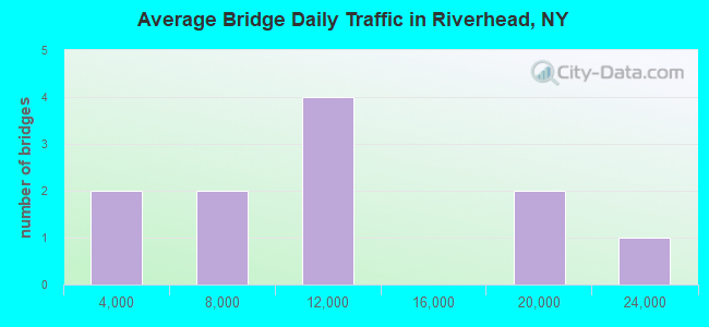
- 119,697Total average daily traffic
- 5,867Total average daily truck traffic
- National Bridge Inventory (NBI) Registered Bridges for Riverhead
- No street view available for this location
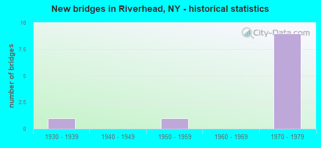
- New bridges - historical statistics
- 11930-1939
- 11950-1959
- 91970-1979
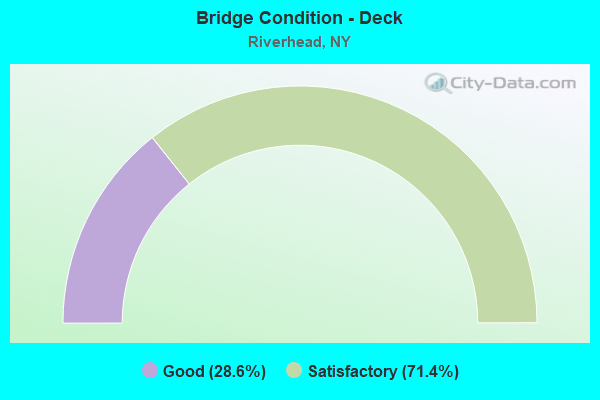
- Bridge Condition - Deck
- 28.6%Good
- 71.4%Satisfactory
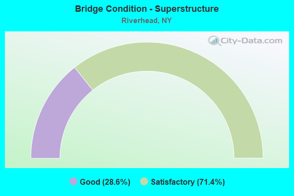
- Bridge Condition - Superstructure
- 28.6%Good
- 71.4%Satisfactory
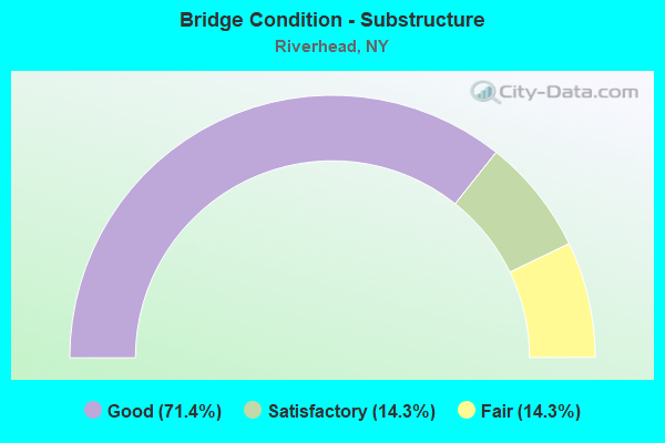
- Bridge Condition - Substructure
- 71.4%Good
- 14.3%Satisfactory
- 14.3%Fair
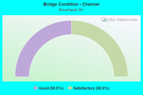
- Bridge Condition - Channel
- 50.0%Good
- 50.0%Satisfactory
Find on map >> Show street view
Structure Number: 3300689, Location: AT RIVERHEAD (Lat: 40.917664, Lng: -72.669097), Route carried "on" structure: County highway , Year Built: 1957, Status: Open, Structure Length: 1.31m (4.30ft), Average Daily Traffic: 17,304 (year 2020), Truck Traffic: 5%, Average Future Daily Traffic: 21,020 (year 2040), Design Load: HS 20, Features Intersected: PECONIC RIVER, Facility Carried by Structure: CENTER DRIVE
Minimum Vertical Clearance: 30+ m (98+ ft), Kilometerpoint: 0.161, Lanes on structure: 4, Owner: County Highway Agency, Approaching Roadway Width: 14.6m (47.9ft), Skew: 20 degrees, Material/Design: Concrete, Design/Construction: Tee Beam, Number Of Spans In Main Unit: 1, Length of Maximum Span: 12.1m (39.7ft), Curb or Sidewalk Widths: Left: 2.1m (6.9ft), Right: 2.1m (6.9ft), Curb-To-Curb Width: 14.6m (47.9ft), Out-to-Out Width: 21.3m (69.9ft)
Condition: Deck: Satisfactory, Superstructure: Satisfactory, Substructure: Fair, Channel: Satisfactory, Operating Rating: 39.5 metric tons, Method Used To Determine Operating Rating: Load and Resistance Factor Rating (LRFR) rating reported by rating factor(RF) method using HL-93 loadings, Inventory Rating: 30.5 metric tons, Method Used To Determine Inventory Rating: Load and Resistance Factor Rating (LRFR) rating reported by rating factor(RF) method using HL-93 loadings, Structural Evaluation: Somewhat better than minimum adequacy, Deck Geometry: High priority of replacement, Waterway Adequacy: Meets minimum limits, Approach Roadway Alignment: Meets minimum limits, Length Of Structure Improvement: 1.31m (4.30ft), Designated Inspection Frequency: Every 24 months, Inspection Date: March 2020, Bridge Improvement Cost: $1,441,000, Roadway Improvement Cost: $844,000, Total Project Cost: $2,285,000 ( Estimate for 2021), Deck Structure Type: Concrete Cast-file-Place, Wearing Surface/Protective System: Wearing Surface: Bituminous
Find on map >> Show street view
Structure Number: 330085, Location: AT RIVERHEAD (Lat: 40.915986, Lng: -72.662611), Route carried "on" structure: County highway , Year Built: 1930, Status: Open, Structure Length: 0.85m (2.79ft), Average Daily Traffic: 17,700 (year 2018), Truck Traffic: 5%, Average Future Daily Traffic: 21,501 (year 2040), Features Intersected: PECONIC RIVER, Facility Carried by Structure: PECONIC AVE
Minimum Vertical Clearance: 30+ m (98+ ft), Kilometerpoint: 0.129, Lanes on structure: 2, Owner: County Highway Agency, Approaching Roadway Width: 14.6m (47.9ft), Skew: 21 degrees, Material/Design: Steel, Number Of Spans In Main Unit: 1, Length of Maximum Span: 8.2m (26.9ft), Curb or Sidewalk Widths: Left: 2.7m (8.9ft), Right: 2.7m (8.9ft), Curb-To-Curb Width: 14.6m (47.9ft), Out-to-Out Width: 20.1m (65.9ft)
Condition: Deck: Satisfactory, Superstructure: Satisfactory, Substructure: Satisfactory, Channel: Good, Operating Rating: 69.0 metric tons, Method Used To Determine Operating Rating: Field evaluation and documented engineering judgment, Inventory Rating: 29.8 metric tons, Method Used To Determine Inventory Rating: Field evaluation and documented engineering judgment, Structural Evaluation: Equal to present minimum criteria, Deck Geometry: Superior to present desirable criteria, Waterway Adequacy: Somewhat better than minimum adequacy, Approach Roadway Alignment: Equal to present desirable criteria, Length Of Structure Improvement: 0.85m (2.79ft), Designated Inspection Frequency: Every 24 months, Inspection Date: March 2020, Bridge Improvement Cost: $1,112,000, Roadway Improvement Cost: $651,000, Total Project Cost: $1,763,000 ( Estimate for 2021), Deck Structure Type: Concrete Cast-file-Place, Wearing Surface/Protective System: Wearing Surface: Bituminous, Membrane: Other
Find on map >> Show street view
Structure Number: 336446, Location: 2 MI E OF RIVERHEAD (Lat: 40.918189, Lng: -72.638611), Route carried "on" structure: County highway , Year Built: 1975, Status: Open, Structure Length: 22.49m (73.79ft), Average Daily Traffic: 22,897 (year 2020), Truck Traffic: 6%, Average Future Daily Traffic: 26,418 (year 2040), Design Load: HS 20, Features Intersected: PECONIC RIVER, Facility Carried by Structure: CROSS RIVER DR
Minimum Vertical Clearance: 30+ m (98+ ft), Kilometerpoint: 2.204, Lanes on structure: 4, Owner: County Highway Agency, Approaching Roadway Width: 17.1m (56.1ft), Skew: 20 degrees, Navigation Control: Yes ( Vertical Clearance: 7.6m (24.9ft), Horizontal Clearance: 26.8m (87.9ft)), Material/Design: Prestressed concrete, Design/Construction: Stringer/Multi-beam, Number Of Spans In Main Unit: 7, Length of Maximum Span: 31.0m (101.7ft), Curb or Sidewalk Widths: Left: 0.7m (2.3ft), Right: 0.7m (2.3ft), Curb-To-Curb Width: 17.1m (56.1ft), Out-to-Out Width: 19.2m (63.0ft)
Condition: Deck: Satisfactory, Superstructure: Satisfactory, Substructure: Good, Operating Rating: 55.3 metric tons, Method Used To Determine Operating Rating: Load Factor (LF), Inventory Rating: 33.6 metric tons, Method Used To Determine Inventory Rating: Load Factor (LF), Structural Evaluation: Equal to present minimum criteria, Deck Geometry: Somewhat better than minimum adequacy, Waterway Adequacy: Somewhat better than minimum adequacy, Approach Roadway Alignment: Meets minimum limits, Length Of Structure Improvement: 22.49m (73.79ft), Designated Inspection Frequency: Every 24 months, Underwater Inspection Frequency: Every 60 months, Inspection Date: September 2020, Underwater Inspection Date: June 2017, Bridge Improvement Cost: $11,495,000, Roadway Improvement Cost: $6,731,000, Total Project Cost: $18,226,000 ( Estimate for 2021), Deck Structure Type: Concrete Cast-file-Place, Wearing Surface/Protective System: Wearing Surface: Monolithic Concrete
Find on map >> Show street view
Structure Number: 3364471, Location: 2 MI E OF RIVERHEAD (Lat: 40.927339, Lng: -72.633639), Route carried "on" structure: County highway , Year Built: 1975, Status: Open, Structure Length: 0.94m (3.08ft), Average Daily Traffic: 11,449 (year 2020), Truck Traffic: 6%, Average Future Daily Traffic: 13,209 (year 2040), Design Load: HS 20, Features Intersected: PARK ROAD, Facility Carried by Structure: CROSS RIVER DRIVE
Minimum Vertical Clearance: 30+ m (98+ ft), Kilometerpoint: 3.524, Lanes on structure: 2, Lanes under structure: 2, Owner: County Highway Agency, Approaching Roadway Width: 8.5m (27.9ft), Material/Design: Concrete, Design/Construction: Slab, Number Of Spans In Main Unit: 1, Length of Maximum Span: 9.1m (29.9ft), Curb or Sidewalk Widths: Left: 0.8m (2.6ft), Right: 0.8m (2.6ft), Curb-To-Curb Width: 8.5m (27.9ft), Out-to-Out Width: 10.7m (35.1ft)
Condition: Deck: Good, Superstructure: Good, Substructure: Good, Operating Rating: 51.7 metric tons, Method Used To Determine Operating Rating: Load Factor (LF), Inventory Rating: 30.8 metric tons, Method Used To Determine Inventory Rating: Load Factor (LF), Structural Evaluation: Better than present minimum criteria, Deck Geometry: High priority of corrective action, Underclear: High priority of corrective action, Approach Roadway Alignment: Equal to present desirable criteria, Length Of Structure Improvement: 0.94m (3.08ft), Designated Inspection Frequency: Every 24 months, Inspection Date: January 2020, Bridge Improvement Cost: $654,000, Roadway Improvement Cost: $383,000, Total Project Cost: $1,038,000 ( Estimate for 2021), Wearing Surface/Protective System: Wearing Surface: Monolithic Concrete
Find on map >> Show street view
Structure Number: 3364472, Location: 2 MI E OF RIVERHEAD (Lat: 40.927358, Lng: -72.633436), Route carried "on" structure: County highway , Year Built: 1975, Status: Open, Structure Length: 0.94m (3.08ft), Average Daily Traffic: 11,449 (year 2020), Truck Traffic: 6%, Average Future Daily Traffic: 13,209 (year 2040), Design Load: HS 20, Features Intersected: PARK ROAD, Facility Carried by Structure: CROSS RIVER DRIVE
Minimum Vertical Clearance: 30+ m (98+ ft), Kilometerpoint: 3.524, Lanes on structure: 2, Lanes under structure: 2, Owner: County Highway Agency, Approaching Roadway Width: 8.5m (27.9ft), Material/Design: Concrete, Design/Construction: Slab, Number Of Spans In Main Unit: 1, Length of Maximum Span: 9.1m (29.9ft), Curb or Sidewalk Widths: Left: 0.8m (2.6ft), Right: 0.8m (2.6ft), Curb-To-Curb Width: 8.5m (27.9ft), Out-to-Out Width: 10.7m (35.1ft)
Condition: Deck: Good, Superstructure: Good, Substructure: Good, Operating Rating: 51.7 metric tons, Method Used To Determine Operating Rating: Load Factor (LF), Inventory Rating: 30.8 metric tons, Method Used To Determine Inventory Rating: Load Factor (LF), Structural Evaluation: Better than present minimum criteria, Deck Geometry: High priority of corrective action, Underclear: High priority of corrective action, Approach Roadway Alignment: Equal to present desirable criteria, Length Of Structure Improvement: 0.94m (3.08ft), Designated Inspection Frequency: Every 24 months, Inspection Date: January 2020, Bridge Improvement Cost: $654,000, Roadway Improvement Cost: $383,000, Total Project Cost: $1,038,000 ( Estimate for 2021), Wearing Surface/Protective System: Wearing Surface: Monolithic Concrete
Find on map >> Show street view
Structure Number: 3364481, Location: 2 MI E OF RIVERHEAD (Lat: 40.930539, Lng: -72.635311), Route carried "on" structure: County highway , Year Built: 1975, Status: Open, Structure Length: 5.97m (19.59ft), Average Daily Traffic: 11,449 (year 2020), Truck Traffic: 6%, Average Future Daily Traffic: 13,209 (year 2040), Design Load: HS 20, Features Intersected: HUBBARD AVE, LONG ISLAND, Facility Carried by Structure: CROSS RIVER DR
Minimum Vertical Clearance: 30+ m (98+ ft), Kilometerpoint: 3.862, Lanes on structure: 2, Lanes under structure: 2, Owner: County Highway Agency, Approaching Roadway Width: 8.5m (27.9ft), Material/Design: Prestressed concrete, Design/Construction: Stringer/Multi-beam, Number Of Spans In Main Unit: 2, Length of Maximum Span: 29.3m (96.1ft), Curb or Sidewalk Widths: Left: 0.7m (2.3ft), Right: 0.7m (2.3ft), Curb-To-Curb Width: 8.5m (27.9ft), Out-to-Out Width: 10.7m (35.1ft)
Condition: Deck: Satisfactory, Superstructure: Satisfactory, Substructure: Good, Operating Rating: 58.6 metric tons, Method Used To Determine Operating Rating: Load and Resistance Factor Rating (LRFR) rating reported by rating factor(RF) method using HL-93 loadings, Inventory Rating: 31.8 metric tons, Method Used To Determine Inventory Rating: Load and Resistance Factor Rating (LRFR) rating reported by rating factor(RF) method using HL-93 loadings, Structural Evaluation: Equal to present minimum criteria, Deck Geometry: High priority of corrective action, Underclear: Equal to present minimum criteria, Approach Roadway Alignment: Equal to present desirable criteria, Length Of Structure Improvement: 5.97m (19.59ft), Designated Inspection Frequency: Every 24 months, Inspection Date: September 2020, Bridge Improvement Cost: $2,364,000, Roadway Improvement Cost: $1,384,000, Total Project Cost: $3,748,000 ( Estimate for 2021), Deck Structure Type: Concrete Cast-file-Place, Wearing Surface/Protective System: Wearing Surface: Monolithic Concrete
Find on map >> Show street view
Structure Number: 3364482, Location: 2 MI E OF RIVERHEAD (Lat: 40.930408, Lng: -72.634983), Route carried "on" structure: County highway , Year Built: 1975, Status: Open, Structure Length: 5.97m (19.59ft), Average Daily Traffic: 11,449 (year 2020), Truck Traffic: 6%, Average Future Daily Traffic: 13,209 (year 2040), Design Load: HS 20, Features Intersected: HUBBARD AVE, LONG ISLAND, Facility Carried by Structure: CROSS RIVER DR
Minimum Vertical Clearance: 30+ m (98+ ft), Kilometerpoint: 3.862, Lanes on structure: 2, Lanes under structure: 2, Owner: County Highway Agency, Approaching Roadway Width: 8.5m (27.9ft), Material/Design: Prestressed concrete, Design/Construction: Stringer/Multi-beam, Number Of Spans In Main Unit: 2, Length of Maximum Span: 29.3m (96.1ft), Curb or Sidewalk Widths: Left: 0.7m (2.3ft), Right: 0.7m (2.3ft), Curb-To-Curb Width: 8.5m (27.9ft), Out-to-Out Width: 10.7m (35.1ft)
Condition: Deck: Satisfactory, Superstructure: Satisfactory, Substructure: Good, Operating Rating: 58.6 metric tons, Method Used To Determine Operating Rating: Load and Resistance Factor Rating (LRFR) rating reported by rating factor(RF) method using HL-93 loadings, Inventory Rating: 31.8 metric tons, Method Used To Determine Inventory Rating: Load and Resistance Factor Rating (LRFR) rating reported by rating factor(RF) method using HL-93 loadings, Structural Evaluation: Equal to present minimum criteria, Deck Geometry: High priority of corrective action, Underclear: Better than present minimum criteria, Approach Roadway Alignment: Equal to present desirable criteria, Length Of Structure Improvement: 5.97m (19.59ft), Designated Inspection Frequency: Every 24 months, Inspection Date: September 2020, Bridge Improvement Cost: $2,364,000, Roadway Improvement Cost: $1,384,000, Total Project Cost: $3,748,000 ( Estimate for 2021), Deck Structure Type: Concrete Cast-file-Place, Wearing Surface/Protective System: Wearing Surface: Monolithic Concrete
Find on map >> Show street view
Structure Number: 3364471, Location: 2 MI E OF RIVERHEAD (Lat: 40.927339, Lng: -72.633639), Route carried "under" structure: Other road , Year Built: 1975, Structure Length: 0. m, Average Daily Traffic: 3,000 (year 2021), Features Intersected: PARK ROAD, Facility Carried by Structure: CROSS RIVER DRIVE
Minimum Vertical Clearance: 3.61m (11.84ft), Kilometerpoint: 0.000, Lanes on structure: 2, Lanes under structure: 2, Material/Design: Concrete, Design/Construction: Slab, Length of Maximum Span: 9.1m (29.9ft)
Find on map >> Show street view
Structure Number: 3364472, Location: 2 MI E OF RIVERHEAD (Lat: 40.927358, Lng: -72.633436), Route carried "under" structure: Other road , Year Built: 1975, Structure Length: 0. m, Average Daily Traffic: 3,000 (year 2021), Features Intersected: PARK ROAD, Facility Carried by Structure: CROSS RIVER DRIVE
Minimum Vertical Clearance: 3.53m (11.58ft), Kilometerpoint: 0.000, Lanes on structure: 2, Lanes under structure: 2, Material/Design: Concrete, Design/Construction: Slab, Length of Maximum Span: 9.1m (29.9ft)
Find on map >> Show street view
Structure Number: 3364481, Location: 2 MI E OF RIVERHEAD (Lat: 40.930539, Lng: -72.635311), Route carried "under" structure: Other road , Year Built: 1975, Structure Length: 0. m, Average Daily Traffic: 5,000 (year 2021), Features Intersected: HUBBARD AVE, LONG ISLAND, Facility Carried by Structure: CROSS RIVER DR
Minimum Vertical Clearance: 4.83m (15.85ft), Kilometerpoint: 0.000, Lanes on structure: 2, Lanes under structure: 2, Material/Design: Prestressed concrete, Design/Construction: Stringer/Multi-beam, Length of Maximum Span: 29.3m (96.1ft)
Find on map >> Show street view
Structure Number: 3364482, Location: 2 MI E OF RIVERHEAD (Lat: 40.930408, Lng: -72.634983), Route carried "under" structure: Other road , Year Built: 1975, Structure Length: 0. m, Average Daily Traffic: 5,000 (year 2021), Features Intersected: HUBBARD AVE, LONG ISLAND, Facility Carried by Structure: CROSS RIVER DR
Minimum Vertical Clearance: 4.95m (16.24ft), Kilometerpoint: 0.000, Lanes on structure: 2, Lanes under structure: 2, Material/Design: Prestressed concrete, Design/Construction: Stringer/Multi-beam, Length of Maximum Span: 29.3m (96.1ft)