Bridge Statistics for Rocheport, Missouri (MO)
Condition, Traffic, Stress, Structural Evaluation, Project Costs
- National Bridge Inventory (NBI) Statistics
- 20Number of bridges
- 587ft / 179mTotal length
- $105,246,000Total costs
- 161,320Total average daily traffic
- 36,295Total average daily truck traffic
- National Bridge Inventory (NBI) Registered Bridges for Rocheport
- No street view available for this location
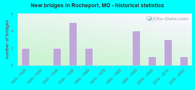
- New bridges - historical statistics
- 21920-1929
- 21940-1949
- 51950-1959
- 21960-1969
- 41990-1999
- 12000-2009
- 32010-2019
- 12020-2022

- Reconstructed bridges - Historical Statistics
- 11940-1949
- 01950-1959
- 11960-1969
- 01970-1979
- 21980-1989


- Bridge Condition - Deck
- 6.7%Excellent
- 13.3%Very good
- 46.7%Good
- 6.7%Satisfactory
- 13.3%Fair
- 6.7%Poor
- 6.7%Serious

- Bridge Condition - Superstructure
- 6.7%Excellent
- 66.7%Good
- 6.7%Satisfactory
- 6.7%Fair
- 13.3%Poor

- Bridge Condition - Substructure
- 6.7%Excellent
- 20.0%Very good
- 26.7%Good
- 26.7%Satisfactory
- 13.3%Fair
- 6.7%Poor

- Bridge Condition - Channel
- 6.7%Excellent
- 13.3%Good
- 46.7%Satisfactory
- 20.0%Fair
- 13.3%Poor
Find on map >> Show street view
Structure Number: 13, Location: S 4 T 48 N R 15 W (Lat: 38.944486, Lng: -92.568639), Route carried "on" structure: Interstate 70, Year Built: 1958, Year Reconstructed: 1988, Status: Open, Structure Length: 4.69m (15.39ft), Average Daily Traffic: 19,939 (year 2021), Truck Traffic: 24%, Average Future Daily Traffic: 35,890 (year 2041), Design Load: HS 20, Features Intersected: UP RR
Minimum Vertical Clearance: 30+ m (98+ ft), Kilometerpoint: 181.950, Lanes on structure: 2, Base Highway Network: Yes, Owner: State Highway Agency, Approaching Roadway Width: 12.8m (42.0ft), Skew: 20 degrees, Material/Design: Steel continuous, Design/Construction: Stringer/Multi-beam, Number Of Spans In Main Unit: 3, Length of Maximum Span: 17.1m (56.1ft), Curb or Sidewalk Widths: Left: 0.2m (0.7ft), Right: 0.2m (0.7ft), Curb-To-Curb Width: 11.5m (37.7ft), Out-to-Out Width: 12.3m (40.4ft)
Condition: Deck: Good, Superstructure: Good, Substructure: Very good, Operating Rating: 81.0 metric tons, Method Used To Determine Operating Rating: Load Factor (LF), Inventory Rating: 48.6 metric tons, Method Used To Determine Inventory Rating: Load Factor (LF), Structural Evaluation: Better than present minimum criteria, Deck Geometry: Somewhat better than minimum adequacy, Approach Roadway Alignment: Equal to present desirable criteria, Designated Inspection Frequency: Every 24 months, Inspection Date: July 2021, Deck Structure Type: Concrete Cast-file-Place, Wearing Surface/Protective System: Wearing Surface: Monolithic Concrete, Deck Protection: Epoxy Coated Reinforcing
Find on map >> Show street view
Structure Number: 15114, Location: S 23 T 49 N R 15 W (Lat: 39.033111, Lng: -92.570833), Route carried "on" structure: County highway 85, Year Built: 1998, Status: Open, Structure Length: 4.02m (13.19ft), Average Daily Traffic: 70 (year 2020), Truck Traffic: 10%, Average Future Daily Traffic: 77 (year 2040), Design Load: HS 20, Features Intersected: MONITEAU CR, Facility Carried by Structure: COUNTY RD 436
Minimum Vertical Clearance: 30+ m (98+ ft), Kilometerpoint: 3.219, Lanes on structure: 2, Owner: County Highway Agency, Approaching Roadway Width: 6.4m (21.0ft), Material/Design: Prestressed concrete, Design/Construction: Tee Beam, Number Of Spans In Main Unit: 3, Length of Maximum Span: 13.1m (43.0ft), Curb-To-Curb Width: 7.2m (23.6ft), Out-to-Out Width: 7.5m (24.6ft)
Condition: Deck: Very good, Superstructure: Good, Substructure: Good, Channel: Satisfactory, Operating Rating: 86.4 metric tons, Method Used To Determine Operating Rating: Load Factor (LF), Inventory Rating: 51.3 metric tons, Method Used To Determine Inventory Rating: Load Factor (LF), Structural Evaluation: Better than present minimum criteria, Deck Geometry: Somewhat better than minimum adequacy, Waterway Adequacy: Equal to present minimum criteria, Approach Roadway Alignment: Better than present minimum criteria, Designated Inspection Frequency: Every 24 months, Inspection Date: Febuary 2020, Deck Structure Type: Concrete Cast-file-Place
Find on map >> Show street view
Structure Number: 15148, Location: S 26 T 49 N R 15 W (Lat: 39.007689, Lng: -92.575086), Route carried "on" structure: County highway 86, Year Built: 1991, Status: Open, Structure Length: 4.21m (13.81ft), Average Daily Traffic: 50 (year 2020), Truck Traffic: 10%, Average Future Daily Traffic: 55 (year 2040), Design Load: HS 20, Features Intersected: MONITEAU CR, Facility Carried by Structure: COUNTY RD 433
Minimum Vertical Clearance: 30+ m (98+ ft), Kilometerpoint: 3.058, Lanes on structure: 2, Owner: County Highway Agency, Approaching Roadway Width: 6.7m (22.0ft), Material/Design: Prestressed concrete, Design/Construction: Tee Beam, Number Of Spans In Main Unit: 3, Length of Maximum Span: 13.4m (44.0ft), Curb-To-Curb Width: 7.3m (24.0ft), Out-to-Out Width: 8.1m (26.6ft)
Condition: Deck: Very good, Superstructure: Good, Substructure: Satisfactory, Channel: Satisfactory, Operating Rating: 54.0 metric tons, Method Used To Determine Operating Rating: Allowable Stress (AS), Inventory Rating: 32.4 metric tons, Method Used To Determine Inventory Rating: Allowable Stress (AS), Structural Evaluation: Equal to present minimum criteria, Deck Geometry: Equal to present minimum criteria, Waterway Adequacy: Better than present minimum criteria, Approach Roadway Alignment: Equal to present desirable criteria, Designated Inspection Frequency: Every 24 months, Inspection Date: Febuary 2020, Deck Structure Type: Concrete Cast-file-Place, Wearing Surface/Protective System: Wearing Surface: Monolithic Concrete
Find on map >> Show street view
Structure Number: 15182, Location: S 14 T 49 N R 15 W (Lat: 39.034706, Lng: -92.570142), Route carried "on" structure: County highway 87, Year Built: 1998, Status: Open, Structure Length: 2.59m (8.50ft), Average Daily Traffic: 70 (year 2020), Truck Traffic: 10%, Average Future Daily Traffic: 77 (year 2040), Features Intersected: PRAIRIE FK CR, Facility Carried by Structure: COUNTY RD 429
Minimum Vertical Clearance: 30+ m (98+ ft), Kilometerpoint: 3.219, Lanes on structure: 2, Owner: County Highway Agency, Approaching Roadway Width: 7.3m (24.0ft), Material/Design: Steel, Design/Construction: Stringer/Multi-beam, Number Of Spans In Main Unit: 1, Length of Maximum Span: 25.3m (83.0ft), Curb-To-Curb Width: 7.2m (23.6ft), Out-to-Out Width: 7.3m (24.0ft)
Condition: Deck: Good, Superstructure: Good, Substructure: Satisfactory, Channel: Satisfactory, Operating Rating: 82.8 metric tons, Method Used To Determine Operating Rating: Load Factor (LF), Inventory Rating: 45.0 metric tons, Method Used To Determine Inventory Rating: Load Factor (LF), Structural Evaluation: Equal to present minimum criteria, Deck Geometry: Somewhat better than minimum adequacy, Waterway Adequacy: Equal to present minimum criteria, Approach Roadway Alignment: High priority of corrective action, Designated Inspection Frequency: Every 24 months, Inspection Date: Febuary 2020, Deck Structure Type: Concrete Cast-file-Place
Find on map >> Show street view
Structure Number: 32118, Location: S 13 T 49 N R 15 W (Lat: 39.035889, Lng: -92.549453), Route carried "on" structure: County highway 88, Year Built: 2007, Status: Open, Structure Length: 3.35m (10.99ft), Average Daily Traffic: 100 (year 2020), Truck Traffic: 25%, Average Future Daily Traffic: 110 (year 2040), Design Load: HS 20, Features Intersected: PRAIRIE FORK CR, Facility Carried by Structure: COUNTY RD 431
Minimum Vertical Clearance: 30+ m (98+ ft), Kilometerpoint: 0.000, Lanes on structure: 2, Owner: County Highway Agency, Approaching Roadway Width: 6.1m (20.0ft), Skew: 2 degrees, Material/Design: Prestressed concrete continuous, Design/Construction: Tee Beam, Number Of Spans In Main Unit: 3, Length of Maximum Span: 12.2m (40.0ft), Curb-To-Curb Width: 7.3m (24.0ft), Out-to-Out Width: 7.5m (24.6ft)
Condition: Deck: Good, Superstructure: Good, Substructure: Good, Channel: Satisfactory, Operating Rating: 58.5 metric tons, Method Used To Determine Operating Rating: Load Factor (LF), Inventory Rating: 35.1 metric tons, Method Used To Determine Inventory Rating: Load Factor (LF), Structural Evaluation: Better than present minimum criteria, Deck Geometry: Equal to present minimum criteria, Waterway Adequacy: Better than present minimum criteria, Approach Roadway Alignment: Equal to present minimum criteria, Designated Inspection Frequency: Every 24 months, Inspection Date: Febuary 2020, Deck Structure Type: Concrete Cast-file-Place, Wearing Surface/Protective System: Wearing Surface: Monolithic Concrete
Find on map >> Show street view
Structure Number: 33809, Location: S 13 T 49 N R 15 W (Lat: 39.034444, Lng: -92.549167), Route carried "on" structure: County highway 88, Year Built: 2011, Status: Open, Structure Length: 1.30m (4.27ft), Average Daily Traffic: 25 (year 2020), Truck Traffic: 5%, Average Future Daily Traffic: 28 (year 2040), Design Load: HS 20, Features Intersected: BR OF PRAIRIE FK, Facility Carried by Structure: COUNTY RD 431
Minimum Vertical Clearance: 30+ m (98+ ft), Kilometerpoint: 2.736, Lanes on structure: 2, Owner: County Highway Agency, Approaching Roadway Width: 6.1m (20.0ft), Material/Design: Concrete, Design/Construction: Channel Beam, Number Of Spans In Main Unit: 1, Length of Maximum Span: 12.5m (41.0ft), Curb-To-Curb Width: 7.5m (24.6ft), Out-to-Out Width: 7.8m (25.6ft)
Condition: Deck: Good, Superstructure: Good, Substructure: Very good, Channel: Satisfactory, Operating Rating: 54.0 metric tons, Method Used To Determine Operating Rating: Load Factor (LF), Inventory Rating: 32.4 metric tons, Method Used To Determine Inventory Rating: Load Factor (LF), Structural Evaluation: Better than present minimum criteria, Deck Geometry: Equal to present minimum criteria, Waterway Adequacy: Better than present minimum criteria, Approach Roadway Alignment: Equal to present desirable criteria, Designated Inspection Frequency: Every 24 months, Inspection Date: Febuary 2020, Deck Structure Type: Concrete Precast Panels, Wearing Surface/Protective System: Wearing Surface: Monolithic Concrete
Find on map >> Show street view
Structure Number: 3381, Location: S 19 T 49 N R 14 W (Lat: 39.033194, Lng: -92.548639), Route carried "on" structure: County highway 88, Year Built: 2011, Status: Open, Structure Length: 1.45m (4.76ft), Average Daily Traffic: 25 (year 2020), Truck Traffic: 5%, Average Future Daily Traffic: 28 (year 2040), Design Load: HS 20, Features Intersected: BR OF PRAIRIE FK, Facility Carried by Structure: COUNTY RD 431
Minimum Vertical Clearance: 30+ m (98+ ft), Kilometerpoint: 2.897, Lanes on structure: 2, Owner: County Highway Agency, Approaching Roadway Width: 6.1m (20.0ft), Skew: 4 degrees, Material/Design: Concrete, Design/Construction: Channel Beam, Number Of Spans In Main Unit: 1, Length of Maximum Span: 14.0m (45.9ft), Curb-To-Curb Width: 7.5m (24.6ft), Out-to-Out Width: 7.8m (25.6ft)
Condition: Deck: Good, Superstructure: Good, Substructure: Very good, Channel: Satisfactory, Operating Rating: 54.0 metric tons, Method Used To Determine Operating Rating: Load Factor (LF), Inventory Rating: 32.4 metric tons, Method Used To Determine Inventory Rating: Load Factor (LF), Structural Evaluation: Better than present minimum criteria, Deck Geometry: Equal to present minimum criteria, Waterway Adequacy: Better than present minimum criteria, Approach Roadway Alignment: Equal to present desirable criteria, Designated Inspection Frequency: Every 24 months, Inspection Date: Febuary 2020, Deck Structure Type: Concrete Precast Panels, Wearing Surface/Protective System: Wearing Surface: Monolithic Concrete
Find on map >> Show street view
Structure Number: 33811, Location: S 19 T 49 N R 14 W (Lat: 39.030833, Lng: -92.548333), Route carried "on" structure: County highway 88, Year Built: 2011, Status: Open, Structure Length: 1.46m (4.79ft), Average Daily Traffic: 25 (year 2020), Truck Traffic: 5%, Average Future Daily Traffic: 28 (year 2040), Design Load: HS 20, Features Intersected: BR OF PRAIRIE FK, Facility Carried by Structure: COUNTY RD 431
Minimum Vertical Clearance: 30+ m (98+ ft), Kilometerpoint: 3.058, Lanes on structure: 2, Owner: County Highway Agency, Approaching Roadway Width: 6.1m (20.0ft), Skew: 2 degrees, Material/Design: Concrete, Design/Construction: Channel Beam, Number Of Spans In Main Unit: 1, Length of Maximum Span: 14.0m (45.9ft), Curb-To-Curb Width: 7.5m (24.6ft), Out-to-Out Width: 7.8m (25.6ft)
Condition: Deck: Good, Superstructure: Good, Substructure: Good, Channel: Satisfactory, Operating Rating: 54.0 metric tons, Method Used To Determine Operating Rating: Load Factor (LF), Inventory Rating: 32.4 metric tons, Method Used To Determine Inventory Rating: Load Factor (LF), Structural Evaluation: Better than present minimum criteria, Deck Geometry: Equal to present minimum criteria, Waterway Adequacy: Better than present minimum criteria, Approach Roadway Alignment: Equal to present minimum criteria, Designated Inspection Frequency: Every 24 months, Inspection Date: Febuary 2020, Deck Structure Type: Concrete Precast Panels, Wearing Surface/Protective System: Wearing Surface: Monolithic Concrete
Find on map >> Show street view
Structure Number: 3669, Location: S 33 T 49 N R 15 W (Lat: 38.992189, Lng: -92.616625), Route carried "on" structure: US 40, Year Built: 2023, Status: Not yet open, Structure Length: 17.24m (56.56ft), Average Daily Traffic: 1,753 (year 2021), Truck Traffic: 9%, Average Future Daily Traffic: 2,279 (year 2041), Features Intersected: KATY TRAIL, SALT CR
Minimum Vertical Clearance: 30+ m (98+ ft), Kilometerpoint: 185.490, Lanes on structure: 2, Base Highway Network: Yes, Owner: State Highway Agency, Approaching Roadway Width: 8.5m (27.9ft), Skew: 4 degrees, Material/Design: Steel continuous, Design/Construction: Stringer/Multi-beam, Number Of Spans In Main Unit: 4, Length of Maximum Span: 64.0m (210.0ft), Curb-To-Curb Width: 8.5m (27.9ft), Out-to-Out Width: 9.3m (30.5ft)
Condition: Deck: Excellent, Superstructure: Excellent, Substructure: Excellent, Channel: Excellent, Operating Rating: 67.5 metric tons, Method Used To Determine Operating Rating: Load and Resistance Factor (LRFR), Inventory Rating: 40.5 metric tons, Method Used To Determine Inventory Rating: Load and Resistance Factor (LRFR), Structural Evaluation: Superior to present desirable criteria, Deck Geometry: Somewhat better than minimum adequacy, Waterway Adequacy: Superior to present desirable criteria, Approach Roadway Alignment: Equal to present desirable criteria, Designated Inspection Frequency: Every 24 months, Inspection Date: December 2021, Deck Structure Type: Concrete Cast-file-Place, Wearing Surface/Protective System: Wearing Surface: Monolithic Concrete, Deck Protection: Epoxy Coated Reinforcing
Find on map >> Show street view
Structure Number: 4114, Location: S 13 T 50 N R 13 W (Lat: 39.125047, Lng: -92.332592), Route carried "on" structure: US 63, Year Built: 1994, Status: Open, Structure Length: 7.47m (24.51ft), Average Daily Traffic: 9,698 (year 2021), Truck Traffic: 26%, Average Future Daily Traffic: 16,002 (year 2041), Design Load: HS 20+Mod, Features Intersected: SILVER FK CR
Minimum Vertical Clearance: 30+ m (98+ ft), Kilometerpoint: 370.419, Lanes on structure: 2, Base Highway Network: Yes, Owner: State Highway Agency, Approaching Roadway Width: 12.2m (40.0ft), Material/Design: Prestressed concrete continuous, Design/Construction: Stringer/Multi-beam, Number Of Spans In Main Unit: 4, Length of Maximum Span: 18.7m (61.4ft), Curb or Sidewalk Widths: Left: 0.2m (0.7ft), Right: 0.2m (0.7ft), Curb-To-Curb Width: 11.8m (38.7ft), Out-to-Out Width: 12.6m (41.3ft)
Condition: Deck: Good, Superstructure: Good, Substructure: Good, Channel: Good, Operating Rating: 78.3 metric tons, Method Used To Determine Operating Rating: Load Factor (LF), Inventory Rating: 46.8 metric tons, Method Used To Determine Inventory Rating: Load Factor (LF), Structural Evaluation: Better than present minimum criteria, Deck Geometry: Better than present minimum criteria, Waterway Adequacy: Equal to present desirable criteria, Approach Roadway Alignment: Equal to present desirable criteria, Designated Inspection Frequency: Every 24 months, Inspection Date: September 2021, Deck Structure Type: Concrete Cast-file-Place, Wearing Surface/Protective System: Wearing Surface: Monolithic Concrete, Deck Protection: Epoxy Coated Reinforcing
Find on map >> Show street view
Structure Number: 4688, Location: S 1 T 48 N R 15 W (Lat: 38.986467, Lng: -92.552547), Route carried "on" structure: US 40, Year Built: 1924, Year Reconstructed: 1947, Status: Open, Structure Length: 0.76m (2.49ft), Average Daily Traffic: 4,637 (year 2021), Truck Traffic: 8%, Average Future Daily Traffic: 8,578 (year 2041), Design Load: H 20, Features Intersected: MC GILL BR
Minimum Vertical Clearance: 30+ m (98+ ft), Kilometerpoint: 191.543, Lanes on structure: 2, Base Highway Network: Yes, Owner: State Highway Agency, Approaching Roadway Width: 13.4m (44.0ft), Material/Design: Concrete continuous, Design/Construction: Culvert, Number Of Spans In Main Unit: 2, Length of Maximum Span: 3.7m (12.1ft)
Condition: Channel: Fair, Culverts: Good, Operating Rating: 90.9 metric tons, Method Used To Determine Operating Rating: Load Factor (LF), Inventory Rating: 54.0 metric tons, Method Used To Determine Inventory Rating: Load Factor (LF), Structural Evaluation: Better than present minimum criteria, Waterway Adequacy: Equal to present minimum criteria, Approach Roadway Alignment: Equal to present desirable criteria, Designated Inspection Frequency: Every 24 months, Inspection Date: September 2021
Find on map >> Show street view
Structure Number: 4821, Location: S 36 T 49 N R 15 W (Lat: 38.992994, Lng: -92.564911), Route carried "on" structure: US 40, Year Built: 1941, Status: Open, Structure Length: 11.34m (37.20ft), Average Daily Traffic: 4,637 (year 2021), Truck Traffic: 8%, Average Future Daily Traffic: 6,028 (year 2041), Design Load: H 20, Features Intersected: MONITEAU CREEK
Minimum Vertical Clearance: 30+ m (98+ ft), Kilometerpoint: 190.189, Lanes on structure: 2, Base Highway Network: Yes, Owner: State Highway Agency, Approaching Roadway Width: 6.7m (22.0ft), Material/Design: Steel continuous, Design/Construction: Stringer/Multi-beam, Number Of Spans In Main Unit: 6, Length of Maximum Span: 23.8m (78.1ft), Curb-To-Curb Width: 8.9m (29.2ft), Out-to-Out Width: 9.0m (29.5ft)
Condition: Deck: Fair, Superstructure: Satisfactory, Substructure: Satisfactory, Channel: Fair, Operating Rating: 40.5 metric tons, Method Used To Determine Operating Rating: Load Factor (LF), Inventory Rating: 24.3 metric tons, Method Used To Determine Inventory Rating: Load Factor (LF), Structural Evaluation: Equal to present minimum criteria, Deck Geometry: Meets minimum limits, Waterway Adequacy: Equal to present minimum criteria, Approach Roadway Alignment: Equal to present minimum criteria, Designated Inspection Frequency: Every 24 months, Inspection Date: September 2021, Deck Structure Type: Concrete Cast-file-Place, Wearing Surface/Protective System: Wearing Surface: Latex Concrete
Find on map >> Show street view
Structure Number: 4937, Location: S 22 T 49 N R 15 W (Lat: 39.021756, Lng: -92.591669), Route carried "on" structure: State highway 240, Year Built: 1926, Status: Open, Structure Length: 1.01m (3.31ft), Average Daily Traffic: 2,851 (year 2021), Truck Traffic: 5%, Average Future Daily Traffic: 3,706 (year 2041), Design Load: H 15, Features Intersected: PIPES BR
Minimum Vertical Clearance: 30+ m (98+ ft), Kilometerpoint: 80.240, Lanes on structure: 2, Base Highway Network: Yes, Owner: State Highway Agency, Approaching Roadway Width: 6.7m (22.0ft), Material/Design: Concrete, Design/Construction: Tee Beam, Number Of Spans In Main Unit: 1, Length of Maximum Span: 9.1m (29.9ft), Curb-To-Curb Width: 6.9m (22.6ft), Out-to-Out Width: 7.1m (23.3ft)
Condition: Deck: Fair, Superstructure: Fair, Substructure: Satisfactory, Channel: Fair, Operating Rating: 52.2 metric tons, Method Used To Determine Operating Rating: Load Factor (LF), Inventory Rating: 31.5 metric tons, Method Used To Determine Inventory Rating: Load Factor (LF), Structural Evaluation: Somewhat better than minimum adequacy, Deck Geometry: High priority of replacement, Waterway Adequacy: Equal to present minimum criteria, Approach Roadway Alignment: Equal to present minimum criteria, Length Of Structure Improvement: 0.17m (0.56ft), Designated Inspection Frequency: Every 24 months, Inspection Date: June 2021, Bridge Improvement Cost: $146,000, Roadway Improvement Cost: $15,000, Total Project Cost: $219,000 ( Estimate for 2022), Deck Structure Type: Concrete Cast-file-Place, Wearing Surface/Protective System: Wearing Surface: Bituminous, Membrane: Built-up
Find on map >> Show street view
Structure Number: 5969, Location: S 1 T 48 N R 15 W (Lat: 38.981333, Lng: -92.566475), Route carried "on" structure: Spur State highway 240, Year Built: 1963, Year Reconstructed: 1968, Status: Open, Structure Length: 8.30m (27.23ft), Average Daily Traffic: 337 (year 2021), Truck Traffic: 19%, Average Future Daily Traffic: 421 (year 2041), Design Load: H 15, Features Intersected: MONITEAU CREEK
Minimum Vertical Clearance: 30+ m (98+ ft), Kilometerpoint: 1.545, Lanes on structure: 2, Owner: State Highway Agency, Approaching Roadway Width: 7.9m (25.9ft), Skew: 2 degrees, Material/Design: Steel continuous, Design/Construction: Stringer/Multi-beam, Number Of Spans In Main Unit: 3, Number Of Approach Spans: 2, Length of Maximum Span: 25.9m (85.0ft), Curb-To-Curb Width: 7.9m (25.9ft), Out-to-Out Width: 9.0m (29.5ft)
Condition: Deck: Poor, Superstructure: Poor, Substructure: Fair, Channel: Good, Operating Rating: 32.4 metric tons, Method Used To Determine Operating Rating: Load Factor (LF), Inventory Rating: 18.9 metric tons, Method Used To Determine Inventory Rating: Load Factor (LF), Structural Evaluation: Meets minimum limits, Deck Geometry: Somewhat better than minimum adequacy, Waterway Adequacy: Equal to present desirable criteria, Approach Roadway Alignment: Equal to present desirable criteria, Length Of Structure Improvement: 0.93m (3.05ft), Designated Inspection Frequency: Every 24 months, Inspection Date: September 2021, Bridge Improvement Cost: $951,000, Roadway Improvement Cost: $95,000, Total Project Cost: $1,427,000 ( Estimate for 2022), Deck Structure Type: Concrete Cast-file-Place, Wearing Surface/Protective System: Wearing Surface: Monolithic Concrete
Find on map >> Show street view
Structure Number: 5999, Location: S 33 T 49 N R 15 W (Lat: 38.992189, Lng: -92.616625), Route carried "on" structure: US 40, Year Built: 1941, Status: Open, Structure Length: 17.62m (57.81ft), Average Daily Traffic: 1,753 (year 2021), Truck Traffic: 9%, Average Future Daily Traffic: 2,279 (year 2041), Design Load: H 15, Features Intersected: KATY TRAIL, SALT CR
Minimum Vertical Clearance: 30+ m (98+ ft), Kilometerpoint: 185.451, Lanes on structure: 2, Base Highway Network: Yes, Owner: State Highway Agency, Approaching Roadway Width: 6.7m (22.0ft), Material/Design: Steel continuous, Design/Construction: Stringer/Multi-beam, Number Of Spans In Main Unit: 3, Number Of Approach Spans: 5, Length of Maximum Span: 30.5m (100.1ft), Curb-To-Curb Width: 7.9m (25.9ft), Out-to-Out Width: 9.1m (29.9ft)
Condition: Deck: Serious, Superstructure: Good, Substructure: Fair, Channel: Poor, Operating Rating: 41.4 metric tons, Method Used To Determine Operating Rating: Load Factor (LF), Inventory Rating: 25.2 metric tons, Method Used To Determine Inventory Rating: Load Factor (LF), Structural Evaluation: Somewhat better than minimum adequacy, Deck Geometry: Meets minimum limits, Waterway Adequacy: Equal to present desirable criteria, Approach Roadway Alignment: Equal to present minimum criteria, Length Of Structure Improvement: 1.83m (6.00ft), Designated Inspection Frequency: Every 24 months, Inspection Date: June 2021, Bridge Improvement Cost: $1,566,000, Roadway Improvement Cost: $157,000, Total Project Cost: $2,350,000 ( Estimate for 2022), Deck Structure Type: Concrete Cast-file-Place, Wearing Surface/Protective System: Wearing Surface: Bituminous
Find on map >> Show street view
Structure Number: 6689, Location: S 18 T 48 N R 14 W (Lat: 38.958511, Lng: -92.546956), Route carried "on" structure: Interstate 70, Year Built: 1960, Year Reconstructed: 1993, Status: Open, Structure Length: 91.99m (301.80ft), Average Daily Traffic: 39,097 (year 2021), Truck Traffic: 24%, Average Future Daily Traffic: 70,375 (year 2041), Design Load: H 20, Features Intersected: MISSOURI RVR, KATY TRAIL
Minimum Vertical Clearance: 5.79m (19.00ft), Kilometerpoint: 183.952, Lanes on structure: 4, Base Highway Network: Yes, Owner: State Highway Agency, Approaching Roadway Width: 20.1m (65.9ft), Skew: 30 degrees, Navigation Control: Yes ( Vertical Clearance: 16.8m (55.1ft), Horizontal Clearance: 152.4m (500.0ft)), Material/Design: Steel continuous, Design/Construction: Truss - Thru, Number Of Spans In Main Unit: 2, Number Of Approach Spans: 15, Length of Maximum Span: 167.9m (550.9ft), Curb or Sidewalk Widths: Left: 0.2m (0.7ft), Right: 0.2m (0.7ft), Curb-To-Curb Width: 18.4m (60.4ft), Out-to-Out Width: 19.2m (63.0ft)
Condition: Deck: Satisfactory, Superstructure: Poor, Substructure: Poor, Channel: Poor, Operating Rating: 45.9 metric tons, Method Used To Determine Operating Rating: Load Factor (LF), Inventory Rating: 27.9 metric tons, Method Used To Determine Inventory Rating: Load Factor (LF), Structural Evaluation: Meets minimum limits, Deck Geometry: Meets minimum limits, Waterway Adequacy: Equal to present desirable criteria, Approach Roadway Alignment: Equal to present desirable criteria, Length Of Structure Improvement: 9.20m (30.18ft), Designated Inspection Frequency: Every 24 months, Critical Feature Inspection Frequency: Every 24 months, Underwater Inspection Frequency: Every 60 months, Inspection Date: April 2021, Critical Feature Inspection Date: April 2021, Underwater Inspection Date: July 2020, Bridge Improvement Cost: $67,500,000, Roadway Improvement Cost: $6,750,000, Total Project Cost: $101,250,000 ( Estimate for 2022), Deck Structure Type: Concrete Cast-file-Place, Wearing Surface/Protective System: Wearing Surface: Monolithic Concrete, Deck Protection: Epoxy Coated Reinforcing
Find on map >> Show street view
Structure Number: 129, Location: S 7 T 48 N R 14 W (Lat: 38.966906, Lng: -92.533672), Route carried "under" structure: Interstate 70, Year Built: 1958, Structure Length: 0. m, Average Daily Traffic: 19,939 (year 2021), Truck Traffic: 24%, Features Intersected: IS 70, Facility Carried by Structure: RT BB E
Minimum Vertical Clearance: 5.46m (17.91ft), Kilometerpoint: 185.891, Lanes on structure: 2, Lanes under structure: 2, Material/Design: Concrete continuous, Design/Construction: Slab, Length of Maximum Span: 19.2m (63.0ft)
Find on map >> Show street view
Structure Number: 129, Location: S 7 T 48 N R 14 W (Lat: 38.966906, Lng: -92.533672), Route carried "under" structure: Interstate 70, Year Built: 1958, Structure Length: 0. m, Average Daily Traffic: 19,738 (year 2021), Truck Traffic: 24%, Features Intersected: IS 70, Facility Carried by Structure: RT BB E
Minimum Vertical Clearance: 5.04m (16.54ft), Kilometerpoint: 216.441, Lanes on structure: 2, Lanes under structure: 2, Material/Design: Concrete continuous, Design/Construction: Slab, Length of Maximum Span: 19.2m (63.0ft)
Find on map >> Show street view
Structure Number: 8, Location: S 13 T 48 N R 16 W (Lat: 38.939633, Lng: -92.596894), Route carried "under" structure: Interstate 70, Year Built: 1958, Structure Length: 0. m, Average Daily Traffic: 19,158 (year 2021), Truck Traffic: 24%, Features Intersected: IS 70, Facility Carried by Structure: MO 179 S
Minimum Vertical Clearance: 4.98m (16.34ft), Kilometerpoint: 222.965, Lanes on structure: 2, Lanes under structure: 2, Material/Design: Steel continuous, Design/Construction: Stringer/Multi-beam, Length of Maximum Span: 18.3m (60.0ft)
Find on map >> Show street view
Structure Number: 8, Location: S 13 T 48 N R 16 W (Lat: 38.939633, Lng: -92.596894), Route carried "under" structure: Interstate 70, Year Built: 1958, Structure Length: 0. m, Average Daily Traffic: 17,418 (year 2021), Truck Traffic: 24%, Features Intersected: IS 70, Facility Carried by Structure: MO 179 S
Minimum Vertical Clearance: 4.88m (16.01ft), Kilometerpoint: 179.373, Lanes on structure: 2, Lanes under structure: 2, Material/Design: Steel continuous, Design/Construction: Stringer/Multi-beam, Length of Maximum Span: 18.3m (60.0ft)