Bridge Statistics for Rock Point, Arizona (AZ)
Condition, Traffic, Stress, Structural Evaluation, Project Costs
- National Bridge Inventory (NBI) Statistics
- 10Number of bridges
- 174ft / 52.7mTotal length
- $3,554,000Total costs
- 32,860Total average daily traffic
- 723Total average daily truck traffic
- 32,916Total future (year 2040) average daily traffic
- National Bridge Inventory (NBI) Registered Bridges for Rock Point
- No street view available for this location
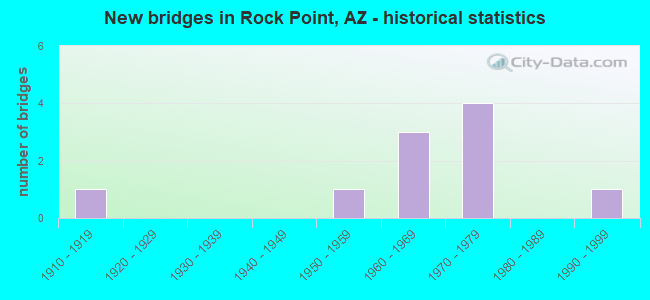
- New bridges - historical statistics
- 11910-1919
- 11950-1959
- 31960-1969
- 41970-1979
- 11990-1999

- Reconstructed bridges - Historical Statistics
- 11980-1989
- 11990-1999
- 12000-2009


- Bridge Condition - Deck
- 57.1%Good
- 14.3%Satisfactory
- 28.6%Fair

- Bridge Condition - Superstructure
- 28.6%Good
- 42.9%Satisfactory
- 28.6%Fair

- Bridge Condition - Substructure
- 14.3%Good
- 42.9%Satisfactory
- 28.6%Fair
- 14.3%Poor

- Bridge Condition - Channel
- 11.1%Very good
- 44.4%Good
- 22.2%Satisfactory
- 11.1%Fair
- 11.1%Poor

- Bridge Condition - Culverts
- 66.7%Good
- 33.3%Satisfactory
Find on map >> Show street view
Structure Number: N248, Location: 7.7MI E,8.2MI N ROCKPOINT (Lat: 36.840528, Lng: -109.482639), Route carried "on" structure: Federal lands road N35, Year Built: 1977, Year Reconstructed: 1993, Status: Posted for load, Structure Length: 2.74m (8.99ft), Average Daily Traffic: 192 (year 2021), Truck Traffic: 5%, Average Future Daily Traffic: 355 (year 2040), Features Intersected: WALKER CREEK
Minimum Vertical Clearance: 30+ m (98+ ft), Kilometerpoint: 20.917, Lanes on structure: 1, Owner: Bureau of Indian Affairs, Approaching Roadway Width: 4.0m (13.1ft), Material/Design: Steel continuous, Design/Construction: Stringer/Multi-beam, Number Of Spans In Main Unit: 3, Length of Maximum Span: 9.4m (30.8ft), Curb or Sidewalk Widths: Left: 0.2m (0.7ft), Right: 0.2m (0.7ft), Curb-To-Curb Width: 4.0m (13.1ft), Out-to-Out Width: 4.4m (14.4ft)
Condition: Deck: Satisfactory, Superstructure: Satisfactory, Substructure: Poor, Channel: Poor, Operating Rating: 3.0 metric tons, Method Used To Determine Operating Rating: No rating analysis performed, Inventory Rating: 3.0 metric tons, Method Used To Determine Inventory Rating: No rating analysis performed, Structural Evaluation: High priority of replacement, Deck Geometry: High priority of replacement, Waterway Adequacy: Somewhat better than minimum adequacy, Approach Roadway Alignment: Meets minimum limits, Bridge Posting: Required (Relationship of Operating Rating to Maximum Legal Load: > 39.9% below), Length Of Structure Improvement: 3.50m (11.48ft), Designated Inspection Frequency: Every 24 months, Inspection Date: December 2021, Bridge Improvement Cost: $884,000, Roadway Improvement Cost: $60,000, Total Project Cost: $1,122,000 ( Estimate for 2021), Deck Structure Type: Open Grating
Find on map >> Show street view
Structure Number: N252, Location: WEST EDGE OF ROCK POINT (Lat: 36.718222, Lng: -109.630444), Route carried "on" structure: Federal lands road N8070, Year Built: 1978, Status: Open, Structure Length: 18.36m (60.24ft), Average Daily Traffic: 527 (year 2022), Truck Traffic: 3%, Average Future Daily Traffic: 350 (year 2040), Design Load: HS 20, Features Intersected: CHINLE WASH
Minimum Vertical Clearance: 30+ m (98+ ft), Kilometerpoint: 0.322, Lanes on structure: 1, Owner: Bureau of Indian Affairs, Approaching Roadway Width: 7.8m (25.6ft), Material/Design: Prestressed concrete, Design/Construction: Box Beam or Girders - Multiple, Number Of Spans In Main Unit: 12, Length of Maximum Span: 15.3m (50.2ft), Curb-To-Curb Width: 4.2m (13.8ft), Out-to-Out Width: 4.9m (16.1ft)
Condition: Deck: Good, Superstructure: Good, Substructure: Good, Channel: Satisfactory, Operating Rating: 44.5 metric tons, Method Used To Determine Operating Rating: Allowable Stress (AS), Inventory Rating: 32.7 metric tons, Method Used To Determine Inventory Rating: Allowable Stress (AS), Structural Evaluation: Better than present minimum criteria, Deck Geometry: High priority of replacement, Waterway Adequacy: Somewhat better than minimum adequacy, Approach Roadway Alignment: Somewhat better than minimum adequacy, Length Of Structure Improvement: 18.36m (60.24ft), Designated Inspection Frequency: Every 24 months, Inspection Date: December 2021, Total Project Cost: $2,430,000 ( Estimate for 2021), Deck Structure Type: Concrete Cast-file-Place, Wearing Surface/Protective System: Wearing Surface: Bituminous
Find on map >> Show street view
Structure Number: 8473, Location: 1.5 mi Nogales Hwy. (Lat: 31.957600, Lng: -110.936000), Route carried "on" structure: City street , Year Built: 1977, Year Reconstructed: 2014, Status: Open, Structure Length: 1.52m (4.99ft), Average Daily Traffic: 7,774 (year 2019), Truck Traffic: 5%, Average Future Daily Traffic: 7,784 (year 2039), Design Load: HS 20, Features Intersected: Drainage Channel, Facility Carried by Structure: Sahuarita Road
Minimum Vertical Clearance: 9.14m (29.99ft), Kilometerpoint: 0.000, Lanes on structure: 4, Owner: Town or Township Highway Agency, Approaching Roadway Width: 14.6m (47.9ft), Skew: 10 degrees, Material/Design: Concrete continuous, Design/Construction: Culvert, Number Of Spans In Main Unit: 4, Length of Maximum Span: 3.7m (12.1ft), Curb or Sidewalk Widths: Left: 1.5m (4.9ft), Right: 1.5m (4.9ft)
Condition: Channel: Good, Culverts: Good, Operating Rating: 68.0 metric tons, Method Used To Determine Operating Rating: Load Factor (LF), Inventory Rating: 40.8 metric tons, Method Used To Determine Inventory Rating: Load Factor (LF), Structural Evaluation: Better than present minimum criteria, Waterway Adequacy: Better than present minimum criteria, Approach Roadway Alignment: Equal to present desirable criteria, Designated Inspection Frequency: Every 24 months, Inspection Date: July 2021
Find on map >> Show street view
Structure Number: 8474, Location: 1.5 mi W Sandario Rd (Lat: 32.248100, Lng: -111.244300), Route carried "on" structure: County highway , Year Built: 1962, Status: Posted for load, Structure Length: 3.23m (10.60ft), Average Daily Traffic: 742 (year 2020), Average Future Daily Traffic: 752 (year 2040), Features Intersected: Brawley Wash, Facility Carried by Structure: Mile Wide Road
Minimum Vertical Clearance: 30+ m (98+ ft), Kilometerpoint: 0.000, Lanes on structure: 1, Owner: County Highway Agency, Approaching Roadway Width: 7.3m (24.0ft), Material/Design: Steel, Design/Construction: Truss - Thru, Number Of Spans In Main Unit: 1, Number Of Approach Spans: 2, Length of Maximum Span: 18.6m (61.0ft), Curb-To-Curb Width: 5.0m (16.4ft), Out-to-Out Width: 5.5m (18.0ft)
Condition: Deck: Fair, Superstructure: Fair, Substructure: Fair, Channel: Satisfactory, Operating Rating: 10.9 metric tons, Method Used To Determine Operating Rating: Load Factor (LF), Inventory Rating: 6.4 metric tons, Method Used To Determine Inventory Rating: Load Factor (LF), Structural Evaluation: High priority of replacement, Deck Geometry: High priority of replacement, Waterway Adequacy: Meets minimum limits, Approach Roadway Alignment: High priority of replacement, Bridge Posting: Required (Relationship of Operating Rating to Maximum Legal Load: > 39.9% below), Length Of Structure Improvement: 4.05m (13.29ft), Designated Inspection Frequency: Every 24 months, Critical Feature Inspection Frequency: Every 24 months, Inspection Date: August 2021, Critical Feature Inspection Date: August 2021, Total Project Cost: $1,000 ( Estimate for 2021), Deck Structure Type: Wood or Timber, Wearing Surface/Protective System: Wearing Surface: Wood or Timber
Find on map >> Show street view
Structure Number: 8475, Location: 3 mi W Sandario Road (Lat: 32.248100, Lng: -111.270300), Route carried "on" structure: County highway , Year Built: 1965, Status: Posted for load, Structure Length: 1.89m (6.20ft), Average Daily Traffic: 742 (year 2020), Average Future Daily Traffic: 752 (year 2040), Features Intersected: Jones Wash, Facility Carried by Structure: Mile Wide Road
Minimum Vertical Clearance: 30+ m (98+ ft), Kilometerpoint: 0.000, Lanes on structure: 1, Owner: County Highway Agency, Approaching Roadway Width: 7.3m (24.0ft), Material/Design: Steel, Design/Construction: Truss - Thru, Number Of Spans In Main Unit: 1, Length of Maximum Span: 17.7m (58.1ft), Curb-To-Curb Width: 5.1m (16.7ft), Out-to-Out Width: 5.5m (18.0ft)
Condition: Deck: Fair, Superstructure: Fair, Substructure: Fair, Channel: Fair, Operating Rating: 10.9 metric tons, Method Used To Determine Operating Rating: Load Factor (LF), Inventory Rating: 6.4 metric tons, Method Used To Determine Inventory Rating: Load Factor (LF), Structural Evaluation: High priority of replacement, Deck Geometry: High priority of replacement, Waterway Adequacy: Meets minimum limits, Approach Roadway Alignment: High priority of replacement, Bridge Posting: Required (Relationship of Operating Rating to Maximum Legal Load: > 39.9% below), Length Of Structure Improvement: 2.65m (8.69ft), Designated Inspection Frequency: Every 24 months, Critical Feature Inspection Frequency: Every 24 months, Inspection Date: August 2021, Critical Feature Inspection Date: August 2021, Total Project Cost: $1,000 ( Estimate for 2021), Deck Structure Type: Wood or Timber, Wearing Surface/Protective System: Wearing Surface: Wood or Timber
Find on map >> Show street view
Structure Number: 8478, Location: 0.2 mi NE Jct Rancho Vst (Lat: 32.455800, Lng: -110.944100), Route carried "on" structure: City street , Year Built: 1992, Status: Open, Structure Length: 1.83m (6.00ft), Average Daily Traffic: 700 (year 2018), Truck Traffic: 1%, Average Future Daily Traffic: 710 (year 2038), Design Load: HS 20, Features Intersected: Wash, Facility Carried by Structure: Del Webb Boulevard
Minimum Vertical Clearance: 30+ m (98+ ft), Kilometerpoint: 0.000, Lanes on structure: 4, Owner: Town or Township Highway Agency, Approaching Roadway Width: 18.3m (60.0ft), Skew: 2 degrees, Material/Design: Concrete continuous, Design/Construction: Culvert, Number Of Spans In Main Unit: 5, Length of Maximum Span: 3.0m (9.8ft), Curb or Sidewalk Widths: Left: 1.2m (3.9ft), Right: 0.3m (1.0ft)
Condition: Channel: Good, Culverts: Good, Operating Rating: 63.5 metric tons, Method Used To Determine Operating Rating: Load Factor (LF), Inventory Rating: 38.1 metric tons, Method Used To Determine Inventory Rating: Load Factor (LF), Structural Evaluation: Better than present minimum criteria, Waterway Adequacy: Equal to present desirable criteria, Approach Roadway Alignment: Equal to present desirable criteria, Designated Inspection Frequency: Every 48 months, Inspection Date: December 2018
Find on map >> Show street view
Structure Number: 8518, Location: .5 MI N OF THOMAS RD (Lat: 33.488317, Lng: -112.160264), Route carried "on" structure: City street , Year Built: 1959, Status: Open, Structure Length: 1.28m (4.20ft), Average Daily Traffic: 3,700 (year 2020), Truck Traffic: 2%, Average Future Daily Traffic: 3,710 (year 2040), Design Load: HS 15, Features Intersected: Grand Canal, Facility Carried by Structure: 47TH AVE
Minimum Vertical Clearance: 30+ m (98+ ft), Kilometerpoint: 0.000, Lanes on structure: 2, Owner: City or Municipal Highway Agency, Approaching Roadway Width: 12.4m (40.7ft), Skew: 1 degrees, Material/Design: Concrete continuous, Design/Construction: Culvert, Number Of Spans In Main Unit: 3, Length of Maximum Span: 4.9m (16.1ft), Curb or Sidewalk Widths: Left: 2.3m (7.5ft), Right: 1.5m (4.9ft), Curb-To-Curb Width: 12.4m (40.7ft), Out-to-Out Width: 16.8m (55.1ft)
Condition: Channel: Good, Culverts: Satisfactory, Operating Rating: 40.7 metric tons, Method Used To Determine Operating Rating: Load Factor (LF), Inventory Rating: 24.4 metric tons, Method Used To Determine Inventory Rating: Load Factor (LF), Structural Evaluation: Equal to present minimum criteria, Deck Geometry: Equal to present minimum criteria, Waterway Adequacy: Better than present minimum criteria, Approach Roadway Alignment: Equal to present minimum criteria, Designated Inspection Frequency: Every 24 months, Inspection Date: January 2020, Deck Structure Type: Concrete Cast-file-Place, Wearing Surface/Protective System: Wearing Surface: Bituminous
Find on map >> Show street view
Structure Number: 8519, Location: .5 MI N OF GLENDALE AVE (Lat: 33.545469, Lng: -112.056428), Route carried "on" structure: City street , Year Built: 1960, Status: Open, Structure Length: 2.04m (6.69ft), Average Daily Traffic: 13,907 (year 2019), Truck Traffic: 1%, Average Future Daily Traffic: 13,917 (year 2039), Design Load: HS 20, Features Intersected: Arizona Canal, Facility Carried by Structure: 12TH ST
Minimum Vertical Clearance: 30+ m (98+ ft), Kilometerpoint: 0.000, Lanes on structure: 2, Owner: City or Municipal Highway Agency, Approaching Roadway Width: 12.3m (40.4ft), Skew: 3 degrees, Material/Design: Steel continuous, Design/Construction: Stringer/Multi-beam, Number Of Spans In Main Unit: 3, Length of Maximum Span: 7.6m (24.9ft), Curb or Sidewalk Widths: Left: 1.4m (4.6ft), Right: 0.0m, Curb-To-Curb Width: 12.3m (40.4ft), Out-to-Out Width: 13.6m (44.6ft)
Condition: Deck: Good, Superstructure: Satisfactory, Substructure: Satisfactory, Channel: Very good, Operating Rating: 40.6 metric tons, Method Used To Determine Operating Rating: Load Factor (LF), Inventory Rating: 24.3 metric tons, Method Used To Determine Inventory Rating: Load Factor (LF), Structural Evaluation: Equal to present minimum criteria, Deck Geometry: Somewhat better than minimum adequacy, Waterway Adequacy: Equal to present desirable criteria, Approach Roadway Alignment: Better than present minimum criteria, Designated Inspection Frequency: Every 24 months, Inspection Date: January 2020, Deck Structure Type: Concrete Cast-file-Place, Wearing Surface/Protective System: Wearing Surface: Bituminous
Find on map >> Show street view
Structure Number: 8532, Location: SKY HARBOR AIRPORT TERM 3 (Lat: 33.434658, Lng: -112.008806), Route carried "on" structure: , Year Built: 1979, Status: Open, Structure Length: 6.24m (20.47ft), Design Load: Pedestrian, Features Intersected: T3 S Baggage Ramp, Facility Carried by Structure: T3 S Pedestrian
Minimum Vertical Clearance: 2.74m (8.99ft), Kilometerpoint: 0.000, Lanes under structure: 2, Owner: City or Municipal Highway Agency, Approaching Roadway Width: 7.8m (25.6ft), Material/Design: Prestressed concrete, Design/Construction: Tee Beam, Number Of Spans In Main Unit: 4, Length of Maximum Span: 20.6m (67.6ft), Curb-To-Curb Width: 7.8m (25.6ft), Out-to-Out Width: 12.2m (40.0ft)
Condition: Deck: Good, Superstructure: Good, Substructure: Satisfactory, Structural Evaluation: Equal to present minimum criteria, Underclear: High priority of corrective action, Designated Inspection Frequency: Every 24 months, Inspection Date: Febuary 2021, Deck Structure Type: Concrete Cast-file-Place, Wearing Surface/Protective System: Wearing Surface: Monolithic Concrete
Find on map >> Show street view
Structure Number: 8533, Location: 0.5 mi NE I 8 (Lat: 32.727900, Lng: -114.615600), Route carried "on" structure: City street , Year Built: 1914, Year Reconstructed: 2002, Status: Posted for load, Structure Length: 13.53m (44.39ft), Average Daily Traffic: 4,576 (year 2020), Truck Traffic: 2%, Average Future Daily Traffic: 4,586 (year 2040), Design Load: HS 20, Features Intersected: Colorado River, Facility Carried by Structure: Penitentiary Ave
Minimum Vertical Clearance: 4.98m (16.34ft), Kilometerpoint: 0.000, Lanes on structure: 1, Owner: County Highway Agency, Maintenance Responsibility: City or Municipal Highway Agency, Approaching Roadway Width: 7.3m (24.0ft), Material/Design: Steel, Design/Construction: Truss - Thru, Number Of Spans In Main Unit: 1, Number Of Approach Spans: 1, Length of Maximum Span: 102.4m (336.0ft), Curb or Sidewalk Widths: Left: 2.4m (7.9ft), Right: 2.4m (7.9ft), Curb-To-Curb Width: 5.2m (17.1ft), Out-to-Out Width: 10.7m (35.1ft)
Condition: Deck: Good, Superstructure: Satisfactory, Substructure: Satisfactory, Channel: Good, Operating Rating: 18.1 metric tons, Method Used To Determine Operating Rating: Load Factor (LF), Inventory Rating: 10.9 metric tons, Method Used To Determine Inventory Rating: Load Factor (LF), Structural Evaluation: High priority of replacement, Deck Geometry: High priority of replacement, Waterway Adequacy: Better than present minimum criteria, Approach Roadway Alignment: Somewhat better than minimum adequacy, Bridge Posting: Required (Relationship of Operating Rating to Maximum Legal Load: > 39.9% below), Length Of Structure Improvement: 5.09m (16.70ft), Designated Inspection Frequency: Every 24 months, Critical Feature Inspection Frequency: Every 24 months, Inspection Date: June 2021, Critical Feature Inspection Date: June 2021, Deck Structure Type: Steel plate, Wearing Surface/Protective System: Wearing Surface: Low Slump Concrete, Deck Protection: Other