Bridge Statistics for Rockport, Arkansas (AR)
Condition, Traffic, Stress, Structural Evaluation, Project Costs
- National Bridge Inventory (NBI) Statistics
- 30Number of bridges
- 259ft / 79.2mTotal length
- $2,944,000Total costs
- 291,444Total average daily traffic
- 54,424Total average daily truck traffic
- National Bridge Inventory (NBI) Registered Bridges for Rockport
- No street view available for this location
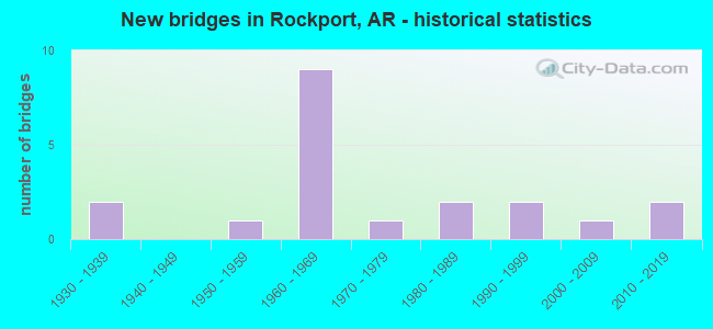
- New bridges - historical statistics
- 21930-1939
- 11950-1959
- 91960-1969
- 11970-1979
- 21980-1989
- 21990-1999
- 12000-2009
- 22010-2019

- Reconstructed bridges - Historical Statistics
- 21990-1999
- 32000-2009


- Bridge Condition - Deck
- 6.7%Excellent
- 33.3%Good
- 40.0%Satisfactory
- 20.0%Fair

- Bridge Condition - Superstructure
- 46.7%Good
- 33.3%Satisfactory
- 20.0%Fair

- Bridge Condition - Substructure
- 6.7%Excellent
- 6.7%Very good
- 13.3%Good
- 46.7%Satisfactory
- 20.0%Fair
- 6.7%Poor

- Bridge Condition - Channel
- 12.5%Very good
- 18.8%Good
- 50.0%Satisfactory
- 18.8%Fair

- Bridge Condition - Culverts
- 40.0%Good
- 60.0%Satisfactory
Find on map >> Show street view
Structure Number: 1381, Location: 2.2 MI S SH 51 (Lat: 33.877939, Lng: -93.305961), Route carried "on" structure: US 67, Year Built: 1931, Status: Open, Structure Length: 35.39m (116.11ft), Average Daily Traffic: 1,492 (year 2018), Truck Traffic: 14%, Average Future Daily Traffic: 1,207 (year 2028), Design Load: H 15, Features Intersected: LITTLE MISSOURI RIVER
Minimum Vertical Clearance: 30+ m (98+ ft), Kilometerpoint: 0.016, Lanes on structure: 2, Owner: State Highway Agency, Approaching Roadway Width: 12.2m (40.0ft), Material/Design: Steel, Design/Construction: Truss - Thru, Number Of Spans In Main Unit: 3, Number Of Approach Spans: 24, Length of Maximum Span: 34.1m (111.9ft), Curb-To-Curb Width: 7.4m (24.3ft), Out-to-Out Width: 8.2m (26.9ft)
Condition: Deck: Fair, Superstructure: Fair, Substructure: Fair, Channel: Fair, Operating Rating: 37.2 metric tons, Method Used To Determine Operating Rating: Allowable Stress (AS), Inventory Rating: 22.7 metric tons, Method Used To Determine Inventory Rating: Allowable Stress (AS), Structural Evaluation: Somewhat better than minimum adequacy, Deck Geometry: Meets minimum limits, Waterway Adequacy: Better than present minimum criteria, Approach Roadway Alignment: Better than present minimum criteria, Designated Inspection Frequency: Every 24 months, Critical Feature Inspection Frequency: Every 24 months, Inspection Date: January 2021, Critical Feature Inspection Date: January 2021, Deck Structure Type: Concrete Cast-file-Place, Wearing Surface/Protective System: Wearing Surface: Bituminous
Find on map >> Show street view
Structure Number: 1381, Location: 0.35 Mi N Jct I-30 (Lat: 34.423875, Lng: -92.797761), Route carried "on" structure: City street 38610, Year Built: 1965, Status: Open, Structure Length: 0.82m (2.69ft), Average Daily Traffic: 1,300 (year 2018), Truck Traffic: 1%, Average Future Daily Traffic: 615 (year 2007), Features Intersected: CREEK, Facility Carried by Structure: Military Rd.
Minimum Vertical Clearance: 30+ m (98+ ft), Kilometerpoint: 0.080, Lanes on structure: 2, Owner: State Highway Agency, Approaching Roadway Width: 7.3m (24.0ft), Material/Design: Concrete, Design/Construction: Culvert, Number Of Spans In Main Unit: 3, Length of Maximum Span: 2.4m (7.9ft)
Condition: Channel: Satisfactory, Culverts: Good, Operating Rating: 50.8 metric tons, Method Used To Determine Operating Rating: Load Factor (LF), Inventory Rating: 30.8 metric tons, Method Used To Determine Inventory Rating: Load Factor (LF), Structural Evaluation: Better than present minimum criteria, Waterway Adequacy: Equal to present desirable criteria, Approach Roadway Alignment: Equal to present desirable criteria, Designated Inspection Frequency: Every 24 months, Critical Feature Inspection Frequency: Every 24 months, Inspection Date: March 2021
Find on map >> Show street view
Structure Number: 1382, Location: 6 MI NE OF MALVERN (Lat: 34.415878, Lng: -92.771522), Route carried "on" structure: County highway 75, Year Built: 1954, Status: Open, Structure Length: 0.73m (2.40ft), Average Daily Traffic: 312 (year 2018), Truck Traffic: 1%, Average Future Daily Traffic: 154 (year 2007), Features Intersected: FRANCOIS CREEK
Minimum Vertical Clearance: 30+ m (98+ ft), Kilometerpoint: 10.009, Lanes on structure: 2, Owner: County Highway Agency, Approaching Roadway Width: 6.1m (20.0ft), Material/Design: Concrete, Design/Construction: Channel Beam, Number Of Spans In Main Unit: 1, Length of Maximum Span: 6.8m (22.3ft), Curb or Sidewalk Widths: Left: 0.2m (0.7ft), Right: 0.2m (0.7ft), Curb-To-Curb Width: 6.2m (20.3ft), Out-to-Out Width: 6.2m (20.3ft)
Condition: Deck: Good, Superstructure: Satisfactory, Substructure: Satisfactory, Channel: Satisfactory, Operating Rating: 53.5 metric tons, Method Used To Determine Operating Rating: Load Factor (LF), Inventory Rating: 32.7 metric tons, Method Used To Determine Inventory Rating: Load Factor (LF), Structural Evaluation: Equal to present minimum criteria, Deck Geometry: Meets minimum limits, Waterway Adequacy: Equal to present minimum criteria, Approach Roadway Alignment: Equal to present minimum criteria, Designated Inspection Frequency: Every 24 months, Critical Feature Inspection Frequency: Every 24 months, Inspection Date: May 2021, Deck Structure Type: Concrete Precast Panels, Wearing Surface/Protective System: Wearing Surface: Bituminous
Find on map >> Show street view
Structure Number: 13837, Location: 4 MI S OF GLEN ROSE (Lat: 34.415764, Lng: -92.739181), Route carried "on" structure: County highway 180, Year Built: 1930, Status: Open, Structure Length: 0.94m (3.08ft), Average Daily Traffic: 111 (year 2018), Truck Traffic: 1%, Average Future Daily Traffic: 135 (year 2007), Features Intersected: REYBURN CREEK
Minimum Vertical Clearance: 30+ m (98+ ft), Kilometerpoint: 2.511, Lanes on structure: 1, Owner: County Highway Agency, Approaching Roadway Width: 5.5m (18.0ft), Material/Design: Concrete, Design/Construction: Arch - Deck, Number Of Spans In Main Unit: 1, Length of Maximum Span: 8.0m (26.2ft), Curb or Sidewalk Widths: Left: 0.1m (0.3ft), Right: 0.1m (0.3ft), Curb-To-Curb Width: 3.4m (11.2ft), Out-to-Out Width: 4.1m (13.5ft)
Condition: Deck: Fair, Superstructure: Fair, Substructure: Fair, Channel: Satisfactory, Operating Rating: 39.9 metric tons, Method Used To Determine Operating Rating: Load Factor (LF), Inventory Rating: 23.6 metric tons, Method Used To Determine Inventory Rating: Load Factor (LF), Structural Evaluation: Somewhat better than minimum adequacy, Deck Geometry: High priority of replacement, Waterway Adequacy: Equal to present minimum criteria, Approach Roadway Alignment: High priority of corrective action, Length Of Structure Improvement: 1.65m (5.41ft), Designated Inspection Frequency: Every 24 months, Critical Feature Inspection Frequency: Every 24 months, Inspection Date: May 2021, Roadway Improvement Cost: $109,000, Total Project Cost: $215,000, Deck Structure Type: Concrete Cast-file-Place, Wearing Surface/Protective System: Wearing Surface: Monolithic Concrete
Find on map >> Show street view
Structure Number: 20518, Location: JCT CO RDS 70 & 71 (Lat: 34.459806, Lng: -92.771308), Route carried "on" structure: County highway 71, Year Built: 1987, Status: Posted for load, Structure Length: 1.58m (5.18ft), Average Daily Traffic: 254 (year 2018), Truck Traffic: 1%, Average Future Daily Traffic: 176 (year 2007), Features Intersected: RAYBURN CREEK
Minimum Vertical Clearance: 30+ m (98+ ft), Kilometerpoint: 3.764, Lanes on structure: 1, Owner: County Highway Agency, Approaching Roadway Width: 5.5m (18.0ft), Material/Design: Steel continuous, Design/Construction: Orthotropic, Number Of Spans In Main Unit: 3, Length of Maximum Span: 4.9m (16.1ft), Curb-To-Curb Width: 6.1m (20.0ft), Out-to-Out Width: 6.1m (20.0ft)
Condition: Deck: Fair, Superstructure: Fair, Substructure: Poor, Channel: Satisfactory, Operating Rating: 48.1 metric tons, Method Used To Determine Operating Rating: Load Factor (LF), Inventory Rating: 29.0 metric tons, Method Used To Determine Inventory Rating: Load Factor (LF), Structural Evaluation: Meets minimum limits, Deck Geometry: Meets minimum limits, Waterway Adequacy: Equal to present minimum criteria, Approach Roadway Alignment: Equal to present minimum criteria, Designated Inspection Frequency: Every 24 months, Critical Feature Inspection Frequency: Every 24 months, Other Special Inspection Frequency: Every 24 months, Inspection Date: March 2020, Critical Feature Inspection Date: March 2021, Other Special Inspection Date: September 2021, Deck Structure Type: Steel plate, Wearing Surface/Protective System: Wearing Surface: Bituminous
Find on map >> Show street view
Structure Number: 20794, Location: 4.2 MI S SALINE CO LINE (Lat: 34.438000, Lng: -92.787781), Route carried "on" structure: County highway 71, Year Built: 1989, Year Reconstructed: 2002, Status: Posted for load, Structure Length: 1.67m (5.48ft), Average Daily Traffic: 899 (year 2018), Truck Traffic: 1%, Average Future Daily Traffic: 424 (year 2007), Features Intersected: FRANCOIS CREEK
Minimum Vertical Clearance: 30+ m (98+ ft), Kilometerpoint: 6.693, Lanes on structure: 1, Owner: County Highway Agency, Approaching Roadway Width: 5.2m (17.1ft), Material/Design: Steel, Design/Construction: Orthotropic, Number Of Spans In Main Unit: 1, Length of Maximum Span: 16.2m (53.1ft), Curb-To-Curb Width: 5.6m (18.4ft), Out-to-Out Width: 5.8m (19.0ft)
Condition: Deck: Satisfactory, Superstructure: Satisfactory, Substructure: Satisfactory, Channel: Fair, Operating Rating: 24.5 metric tons, Method Used To Determine Operating Rating: Load Factor (LF), Inventory Rating: 14.5 metric tons, Method Used To Determine Inventory Rating: Load Factor (LF), Structural Evaluation: Meets minimum limits, Deck Geometry: High priority of replacement, Waterway Adequacy: Somewhat better than minimum adequacy, Approach Roadway Alignment: Equal to present minimum criteria, Bridge Posting: Required (Relationship of Operating Rating to Maximum Legal Load: 20.0 - 29.9% below), Length Of Structure Improvement: 2.41m (7.91ft), Designated Inspection Frequency: Every 24 months, Critical Feature Inspection Frequency: Every 24 months, Inspection Date: May 2021, Critical Feature Inspection Date: May 2021, Roadway Improvement Cost: $109,000, Total Project Cost: $248,000, Deck Structure Type: Steel plate, Wearing Surface/Protective System: Wearing Surface: Bituminous
Find on map >> Show street view
Structure Number: 21163, Location: 2 MI SOUTH GLEN ROSE (Lat: 34.435019, Lng: -92.751511), Route carried "on" structure: County highway 74, Year Built: 1991, Status: Posted for load, Structure Length: 1.37m (4.49ft), Average Daily Traffic: 187 (year 2018), Truck Traffic: 1%, Average Future Daily Traffic: 107 (year 2007), Features Intersected: CREEK
Minimum Vertical Clearance: 30+ m (98+ ft), Kilometerpoint: 4.134, Lanes on structure: 1, Owner: County Highway Agency, Approaching Roadway Width: 6.1m (20.0ft), Material/Design: Steel, Design/Construction: Orthotropic, Number Of Spans In Main Unit: 1, Length of Maximum Span: 12.8m (42.0ft), Curb-To-Curb Width: 5.2m (17.1ft), Out-to-Out Width: 5.4m (17.7ft)
Condition: Deck: Satisfactory, Superstructure: Satisfactory, Substructure: Satisfactory, Channel: Satisfactory, Operating Rating: 46.3 metric tons, Method Used To Determine Operating Rating: Load Factor (LF), Inventory Rating: 27.2 metric tons, Method Used To Determine Inventory Rating: Load Factor (LF), Structural Evaluation: Equal to present minimum criteria, Deck Geometry: High priority of replacement, Waterway Adequacy: Equal to present minimum criteria, Approach Roadway Alignment: Equal to present minimum criteria, Length Of Structure Improvement: 2.10m (6.89ft), Designated Inspection Frequency: Every 24 months, Critical Feature Inspection Frequency: Every 24 months, Inspection Date: March 2020, Critical Feature Inspection Date: March 2021, Roadway Improvement Cost: $109,000, Total Project Cost: $236,000, Deck Structure Type: Steel plate, Wearing Surface/Protective System: Wearing Surface: Bituminous
Find on map >> Show street view
Structure Number: 21352, Location: 2 MI E OF BUTTERFIELD (Lat: 34.426836, Lng: -92.781308), Route carried "on" structure: County highway 80, Year Built: 1993, Status: Open, Structure Length: 0.73m (2.40ft), Average Daily Traffic: 247 (year 2018), Truck Traffic: 1%, Average Future Daily Traffic: 122 (year 2007), Features Intersected: FRANCOIS CREEK
Minimum Vertical Clearance: 30+ m (98+ ft), Kilometerpoint: 2.140, Lanes on structure: 1, Owner: County Highway Agency, Approaching Roadway Width: 5.5m (18.0ft), Material/Design: Steel, Design/Construction: Stringer/Multi-beam, Number Of Spans In Main Unit: 1, Length of Maximum Span: 6.9m (22.6ft), Curb-To-Curb Width: 4.8m (15.7ft), Out-to-Out Width: 4.9m (16.1ft)
Condition: Deck: Satisfactory, Superstructure: Satisfactory, Substructure: Satisfactory, Channel: Satisfactory, Operating Rating: 54.4 metric tons, Method Used To Determine Operating Rating: Load Factor (LF), Inventory Rating: 32.7 metric tons, Method Used To Determine Inventory Rating: Load Factor (LF), Structural Evaluation: Equal to present minimum criteria, Deck Geometry: High priority of corrective action, Waterway Adequacy: Equal to present minimum criteria, Approach Roadway Alignment: Better than present minimum criteria, Designated Inspection Frequency: Every 24 months, Critical Feature Inspection Frequency: Every 24 months, Inspection Date: March 2021, Deck Structure Type: Steel plate, Wearing Surface/Protective System: Wearing Surface: Bituminous
Find on map >> Show street view
Structure Number: 234, Location: .4 Mi. S. Jct CR 15 & 200 (Lat: 33.219700, Lng: -93.285422), Route carried "on" structure: County highway 15, Year Built: 2010, Status: Open, Structure Length: 0.94m (3.08ft), Average Daily Traffic: 1,661 (year 2018), Truck Traffic: 1%, Average Future Daily Traffic: 85 (year 2033), Features Intersected: Ditch / Creek relief
Minimum Vertical Clearance: 30+ m (98+ ft), Kilometerpoint: 21.630, Lanes on structure: 2, Owner: County Highway Agency, Approaching Roadway Width: 7.9m (25.9ft), Material/Design: Concrete, Design/Construction: Channel Beam, Number Of Spans In Main Unit: 1, Length of Maximum Span: 8.5m (27.9ft), Curb-To-Curb Width: 7.4m (24.3ft), Out-to-Out Width: 8.0m (26.2ft)
Condition: Deck: Good, Superstructure: Good, Substructure: Very good, Channel: Very good, Operating Rating: 54.4 metric tons, Method Used To Determine Operating Rating: Load Factor (LF), Inventory Rating: 32.7 metric tons, Method Used To Determine Inventory Rating: Load Factor (LF), Structural Evaluation: Better than present minimum criteria, Deck Geometry: Meets minimum limits, Waterway Adequacy: Equal to present desirable criteria, Approach Roadway Alignment: Equal to present desirable criteria, Designated Inspection Frequency: Every 24 months, Critical Feature Inspection Frequency: Every 24 months, Inspection Date: November 2020, Deck Structure Type: Concrete Precast Panels, Wearing Surface/Protective System: Wearing Surface: Bituminous
Find on map >> Show street view
Structure Number: 24017, Location: 2 MI SW Glenrose (Lat: 34.441711, Lng: -92.748181), Route carried "on" structure: County highway 74, Year Built: 2018, Status: Posted for load, Structure Length: 2.75m (9.02ft), Average Daily Traffic: 187 (year 2018), Truck Traffic: 1%, Features Intersected: Rayburn Creek
Minimum Vertical Clearance: 30+ m (98+ ft), Kilometerpoint: 5.003, Lanes on structure: 1, Owner: County Highway Agency, Approaching Roadway Width: 5.5m (18.0ft), Material/Design: Steel, Design/Construction: Stringer/Multi-beam, Number Of Spans In Main Unit: 1, Length of Maximum Span: 25.8m (84.6ft), Curb-To-Curb Width: 4.7m (15.4ft), Out-to-Out Width: 4.8m (15.7ft)
Condition: Deck: Excellent, Superstructure: Satisfactory, Substructure: Excellent, Channel: Very good, Operating Rating: 25.4 metric tons, Method Used To Determine Operating Rating: Load Factor (LF), Inventory Rating: 15.4 metric tons, Method Used To Determine Inventory Rating: Load Factor (LF), Structural Evaluation: Meets minimum limits, Deck Geometry: High priority of replacement, Waterway Adequacy: Equal to present minimum criteria, Approach Roadway Alignment: High priority of corrective action, Bridge Posting: Required (Relationship of Operating Rating to Maximum Legal Load: 20.0 - 29.9% below), Designated Inspection Frequency: Every 24 months, Critical Feature Inspection Frequency: Every 24 months, Inspection Date: December 2021, Deck Structure Type: Concrete Cast-file-Place
Find on map >> Show street view
Structure Number: 3104, Location: at JCT US 270 & SH 51 (Lat: 34.409619, Lng: -92.821619), Route carried "on" structure: US 270, Year Built: 1976, Status: Open, Structure Length: 0.82m (2.69ft), Average Daily Traffic: 12,000 (year 2018), Truck Traffic: 1%, Average Future Daily Traffic: 19,406 (year 2028), Design Load: H 20, Features Intersected: BRANCH
Minimum Vertical Clearance: 30+ m (98+ ft), Kilometerpoint: 11.265, Lanes on structure: 5, Base Highway Network: Yes, Owner: State Highway Agency, Approaching Roadway Width: 20.7m (67.9ft), Skew: 6 degrees, Material/Design: Concrete, Design/Construction: Culvert, Number Of Spans In Main Unit: 2, Length of Maximum Span: 4.0m (13.1ft)
Condition: Channel: Good, Culverts: Satisfactory, Operating Rating: 29.0 metric tons, Method Used To Determine Operating Rating: Load Factor (LF), Inventory Rating: 17.2 metric tons, Method Used To Determine Inventory Rating: Load Factor (LF), Structural Evaluation: Meets minimum limits, Waterway Adequacy: Equal to present desirable criteria, Approach Roadway Alignment: Equal to present desirable criteria, Designated Inspection Frequency: Every 24 months, Critical Feature Inspection Frequency: Every 24 months, Inspection Date: December 2020
Find on map >> Show street view
Structure Number: A3429, Location: 3.80 MI E US 270 (Lat: 34.437039, Lng: -92.782119), Route carried "on" structure: County highway 74, Year Built: 1964, Status: Open, Structure Length: 3.93m (12.89ft), Average Daily Traffic: 580 (year 1987), Truck Traffic: 1%, Average Future Daily Traffic: 122 (year 2007), Design Load: H 15, Features Intersected: I-30 WB log 101.80
Minimum Vertical Clearance: 30+ m (98+ ft), Kilometerpoint: 0.579, Lanes on structure: 2, Lanes under structure: 2, Owner: State Highway Agency, Approaching Roadway Width: 8.5m (27.9ft), Material/Design: Steel, Design/Construction: Stringer/Multi-beam, Number Of Spans In Main Unit: 3, Length of Maximum Span: 13.4m (44.0ft), Curb or Sidewalk Widths: Left: 0.4m (1.3ft), Right: 0.4m (1.3ft), Curb-To-Curb Width: 7.3m (24.0ft), Out-to-Out Width: 8.6m (28.2ft)
Condition: Deck: Good, Superstructure: Good, Substructure: Good, Operating Rating: 46.3 metric tons, Method Used To Determine Operating Rating: Load Factor (LF), Inventory Rating: 28.1 metric tons, Method Used To Determine Inventory Rating: Load Factor (LF), Structural Evaluation: Better than present minimum criteria, Deck Geometry: Meets minimum limits, Underclear: High priority of corrective action, Approach Roadway Alignment: Equal to present desirable criteria, Length Of Structure Improvement: 3.99m (13.09ft), Designated Inspection Frequency: Every 24 months, Critical Feature Inspection Frequency: Every 24 months, Inspection Date: July 2020, Total Project Cost: $165,000, Deck Structure Type: Concrete Cast-file-Place, Wearing Surface/Protective System: Wearing Surface: Monolithic Concrete
Find on map >> Show street view
Structure Number: A343, Location: 5.7 MI NO JCT 270 & I 30 (Lat: 34.455972, Lng: -92.758003), Route carried "on" structure: Interstate 30, Year Built: 1964, Year Reconstructed: 2000, Status: Open, Structure Length: 7.25m (23.79ft), Average Daily Traffic: 18,000 (year 2018), Truck Traffic: 45%, Average Future Daily Traffic: 20,053 (year 2028), Design Load: HS 20+Mod, Features Intersected: RAYBURN CREEK
Minimum Vertical Clearance: 30+ m (98+ ft), Kilometerpoint: 166.873, Lanes on structure: 2, Base Highway Network: Yes, Owner: State Highway Agency, Approaching Roadway Width: 11.6m (38.1ft), Material/Design: Steel continuous, Design/Construction: Stringer/Multi-beam, Number Of Spans In Main Unit: 4, Length of Maximum Span: 18.0m (59.1ft), Curb-To-Curb Width: 12.1m (39.7ft), Out-to-Out Width: 13.1m (43.0ft)
Condition: Deck: Satisfactory, Superstructure: Good, Substructure: Good, Channel: Good, Operating Rating: 54.4 metric tons, Method Used To Determine Operating Rating: Load Factor (LF), Inventory Rating: 32.7 metric tons, Method Used To Determine Inventory Rating: Load Factor (LF), Structural Evaluation: Better than present minimum criteria, Deck Geometry: Equal to present minimum criteria, Waterway Adequacy: Equal to present desirable criteria, Approach Roadway Alignment: Equal to present desirable criteria, Length Of Structure Improvement: 8.29m (27.20ft), Designated Inspection Frequency: Every 24 months, Critical Feature Inspection Frequency: Every 24 months, Inspection Date: Febuary 2022, Roadway Improvement Cost: $247,000, Total Project Cost: $1,022,000, Deck Structure Type: Concrete Cast-file-Place, Wearing Surface/Protective System: Wearing Surface: Monolithic Concrete, Deck Protection: Epoxy Coated Reinforcing
Find on map >> Show street view
Structure Number: A3431, Location: 6.1 MI N JCT I- 30 & 270 (Lat: 34.460569, Lng: -92.752319), Route carried "on" structure: Interstate 30, Year Built: 1964, Year Reconstructed: 1999, Status: Open, Structure Length: 3.44m (11.29ft), Average Daily Traffic: 18,000 (year 2018), Truck Traffic: 45%, Average Future Daily Traffic: 20,053 (year 2028), Design Load: HS 20+Mod, Features Intersected: CR 70 Stringtown Rd
Minimum Vertical Clearance: 30+ m (98+ ft), Kilometerpoint: 167.597, Lanes on structure: 2, Lanes under structure: 2, Base Highway Network: Yes, Owner: State Highway Agency, Approaching Roadway Width: 12.2m (40.0ft), Skew: 1 degrees, Material/Design: Steel, Design/Construction: Stringer/Multi-beam, Number Of Spans In Main Unit: 3, Length of Maximum Span: 11.3m (37.1ft), Curb-To-Curb Width: 12.1m (39.7ft), Out-to-Out Width: 13.1m (43.0ft)
Condition: Deck: Satisfactory, Superstructure: Good, Substructure: Fair, Operating Rating: 54.4 metric tons, Method Used To Determine Operating Rating: Load Factor (LF), Inventory Rating: 32.7 metric tons, Method Used To Determine Inventory Rating: Load Factor (LF), Structural Evaluation: Somewhat better than minimum adequacy, Deck Geometry: Equal to present minimum criteria, Underclear: Meets minimum limits, Approach Roadway Alignment: Equal to present desirable criteria, Designated Inspection Frequency: Every 24 months, Critical Feature Inspection Frequency: Every 24 months, Inspection Date: July 2020, Deck Structure Type: Concrete Cast-file-Place, Wearing Surface/Protective System: Wearing Surface: Monolithic Concrete, Deck Protection: Epoxy Coated Reinforcing
Find on map >> Show street view
Structure Number: B3429, Location: 3.81 MI E US 270 (Lat: 34.436739, Lng: -92.781611), Route carried "on" structure: County highway 74, Year Built: 1964, Status: Open, Structure Length: 3.75m (12.30ft), Average Daily Traffic: 580 (year 1987), Truck Traffic: 1%, Average Future Daily Traffic: 122 (year 2007), Design Load: H 15, Features Intersected: I-30 EB Log 101.80
Minimum Vertical Clearance: 30+ m (98+ ft), Kilometerpoint: 0.644, Lanes on structure: 2, Lanes under structure: 2, Owner: State Highway Agency, Approaching Roadway Width: 8.2m (26.9ft), Material/Design: Steel, Design/Construction: Stringer/Multi-beam, Number Of Spans In Main Unit: 3, Length of Maximum Span: 13.4m (44.0ft), Curb or Sidewalk Widths: Left: 0.4m (1.3ft), Right: 0.4m (1.3ft), Curb-To-Curb Width: 7.3m (24.0ft), Out-to-Out Width: 8.6m (28.2ft)
Condition: Deck: Satisfactory, Superstructure: Good, Substructure: Satisfactory, Operating Rating: 44.5 metric tons, Method Used To Determine Operating Rating: Load Factor (LF), Inventory Rating: 27.2 metric tons, Method Used To Determine Inventory Rating: Load Factor (LF), Structural Evaluation: Equal to present minimum criteria, Deck Geometry: Meets minimum limits, Underclear: High priority of corrective action, Approach Roadway Alignment: Equal to present desirable criteria, Length Of Structure Improvement: 3.81m (12.50ft), Designated Inspection Frequency: Every 24 months, Critical Feature Inspection Frequency: Every 24 months, Inspection Date: July 2020, Total Project Cost: $36,000, Deck Structure Type: Concrete Cast-file-Place, Wearing Surface/Protective System: Wearing Surface: Monolithic Concrete
Find on map >> Show street view
Structure Number: B343, Location: 1.76 MI S SALINE CO (Lat: 34.455769, Lng: -92.757750), Route carried "on" structure: Interstate 30, Year Built: 1964, Year Reconstructed: 2000, Status: Open, Structure Length: 7.25m (23.79ft), Average Daily Traffic: 18,000 (year 2018), Truck Traffic: 47%, Average Future Daily Traffic: 20,053 (year 2028), Design Load: HS 20+Mod, Features Intersected: RAYBURN CREEK
Minimum Vertical Clearance: 30+ m (98+ ft), Kilometerpoint: 166.889, Lanes on structure: 2, Base Highway Network: Yes, Owner: State Highway Agency, Approaching Roadway Width: 12.5m (41.0ft), Material/Design: Steel, Design/Construction: Stringer/Multi-beam, Number Of Spans In Main Unit: 4, Length of Maximum Span: 18.0m (59.1ft), Curb-To-Curb Width: 12.2m (40.0ft), Out-to-Out Width: 13.1m (43.0ft)
Condition: Deck: Good, Superstructure: Good, Substructure: Satisfactory, Channel: Good, Operating Rating: 54.4 metric tons, Method Used To Determine Operating Rating: Load Factor (LF), Inventory Rating: 32.7 metric tons, Method Used To Determine Inventory Rating: Load Factor (LF), Structural Evaluation: Equal to present minimum criteria, Deck Geometry: Better than present minimum criteria, Waterway Adequacy: Equal to present desirable criteria, Approach Roadway Alignment: Equal to present desirable criteria, Length Of Structure Improvement: 8.29m (27.20ft), Designated Inspection Frequency: Every 24 months, Critical Feature Inspection Frequency: Every 24 months, Inspection Date: Febuary 2022, Roadway Improvement Cost: $247,000, Total Project Cost: $1,022,000, Deck Structure Type: Concrete Cast-file-Place, Wearing Surface/Protective System: Wearing Surface: Monolithic Concrete, Deck Protection: Epoxy Coated Reinforcing
Find on map >> Show street view
Structure Number: B3431, Location: 1.31 MI S OF SALINE CO (Lat: 34.460450, Lng: -92.752089), Route carried "on" structure: Interstate 30, Year Built: 1964, Year Reconstructed: 2000, Status: Open, Structure Length: 3.44m (11.29ft), Average Daily Traffic: 18,000 (year 2018), Truck Traffic: 47%, Average Future Daily Traffic: 20,053 (year 2028), Design Load: HS 20, Features Intersected: CR 70 Stringtown Rd
Minimum Vertical Clearance: 30+ m (98+ ft), Kilometerpoint: 167.613, Lanes on structure: 2, Lanes under structure: 2, Base Highway Network: Yes, Owner: State Highway Agency, Approaching Roadway Width: 12.8m (42.0ft), Skew: 1 degrees, Material/Design: Steel, Design/Construction: Stringer/Multi-beam, Number Of Spans In Main Unit: 3, Length of Maximum Span: 11.3m (37.1ft), Curb-To-Curb Width: 12.2m (40.0ft), Out-to-Out Width: 13.1m (43.0ft)
Condition: Deck: Good, Superstructure: Good, Substructure: Satisfactory, Operating Rating: 54.4 metric tons, Method Used To Determine Operating Rating: Load Factor (LF), Inventory Rating: 32.7 metric tons, Method Used To Determine Inventory Rating: Load Factor (LF), Structural Evaluation: Equal to present minimum criteria, Deck Geometry: Better than present minimum criteria, Underclear: Meets minimum limits, Approach Roadway Alignment: Equal to present desirable criteria, Designated Inspection Frequency: Every 24 months, Critical Feature Inspection Frequency: Every 24 months, Inspection Date: July 2020, Deck Structure Type: Concrete Cast-file-Place, Wearing Surface/Protective System: Wearing Surface: Monolithic Concrete, Deck Protection: Epoxy Coated Reinforcing
Find on map >> Show street view
Structure Number: M3028, Location: 3.5 MI N JCT US 270 (Lat: 34.433897, Lng: -92.785778), Route carried "on" structure: Interstate 30, Year Built: 1964, Status: Open, Structure Length: 0.63m (2.07ft), Average Daily Traffic: 2,996 (year 2018), Truck Traffic: 45%, Average Future Daily Traffic: 20,053 (year 2028), Features Intersected: CREEK
Minimum Vertical Clearance: 30+ m (98+ ft), Kilometerpoint: 163.300, Lanes on structure: 2, Base Highway Network: Yes (Inventory Route: 302, Subroute: 10), Owner: State Highway Agency, Approaching Roadway Width: 12.2m (40.0ft), Material/Design: Concrete, Design/Construction: Culvert, Number Of Spans In Main Unit: 2, Length of Maximum Span: 3.0m (9.8ft)
Condition: Channel: Satisfactory, Culverts: Satisfactory, Operating Rating: 35.4 metric tons, Method Used To Determine Operating Rating: Load Factor (LF), Inventory Rating: 21.8 metric tons, Method Used To Determine Inventory Rating: Load Factor (LF), Structural Evaluation: Somewhat better than minimum adequacy, Waterway Adequacy: Equal to present desirable criteria, Approach Roadway Alignment: Equal to present desirable criteria, Designated Inspection Frequency: Every 24 months, Critical Feature Inspection Frequency: Every 24 months, Inspection Date: June 2020
Find on map >> Show street view
Structure Number: M3029, Location: 3.5 MI N JCT US 270 (Lat: 34.433486, Lng: -92.785481), Route carried "on" structure: Interstate 30, Year Built: 1964, Status: Open, Structure Length: 0.63m (2.07ft), Average Daily Traffic: 36,000 (year 2018), Truck Traffic: 47%, Average Future Daily Traffic: 20,053 (year 2028), Features Intersected: CREEK
Minimum Vertical Clearance: 30+ m (98+ ft), Kilometerpoint: 163.332, Lanes on structure: 2, Base Highway Network: Yes (Inventory Route: 302, Subroute: 10), Owner: State Highway Agency, Approaching Roadway Width: 12.2m (40.0ft), Material/Design: Concrete, Design/Construction: Culvert, Number Of Spans In Main Unit: 2, Length of Maximum Span: 3.0m (9.8ft)
Condition: Channel: Satisfactory, Culverts: Satisfactory, Operating Rating: 35.4 metric tons, Method Used To Determine Operating Rating: Load Factor (LF), Inventory Rating: 21.8 metric tons, Method Used To Determine Inventory Rating: Load Factor (LF), Structural Evaluation: Somewhat better than minimum adequacy, Waterway Adequacy: Equal to present desirable criteria, Approach Roadway Alignment: Equal to present desirable criteria, Designated Inspection Frequency: Every 24 months, Critical Feature Inspection Frequency: Every 24 months, Inspection Date: June 2020
Find on map >> Show street view
Structure Number: X1247, Location: .75 Mi S I 30 (Lat: 34.406819, Lng: -92.793700), Route carried "on" structure: US 270, Year Built: 2005, Status: Open, Structure Length: 1.13m (3.71ft), Average Daily Traffic: 4,326 (year 2018), Truck Traffic: 22%, Average Future Daily Traffic: 5,300 (year 2038), Design Load: H 20, Features Intersected: Creek
Minimum Vertical Clearance: 30+ m (98+ ft), Kilometerpoint: 1.529, Lanes on structure: 2, Base Highway Network: Yes, Owner: State Highway Agency, Approaching Roadway Width: 12.2m (40.0ft), Skew: 4 degrees, Material/Design: Concrete, Design/Construction: Culvert, Number Of Spans In Main Unit: 3, Length of Maximum Span: 3.4m (11.2ft)
Condition: Channel: Fair, Culverts: Good, Operating Rating: 49.9 metric tons, Method Used To Determine Operating Rating: Load Factor (LF), Inventory Rating: 29.9 metric tons, Method Used To Determine Inventory Rating: Load Factor (LF), Structural Evaluation: Better than present minimum criteria, Waterway Adequacy: Equal to present desirable criteria, Approach Roadway Alignment: Equal to present desirable criteria, Designated Inspection Frequency: Every 24 months, Critical Feature Inspection Frequency: Every 24 months, Inspection Date: September 2021
Find on map >> Show street view
Structure Number: 3425, Location: I-30 LOG 98.86 (Lat: 34.404831, Lng: -92.815339), Route carried "under" structure: Interstate 30, Structure Length: 0. m, Average Daily Traffic: 16,500 (year 2014), Truck Traffic: 1%, Features Intersected: I 30-SEC 21, Facility Carried by Structure: Ark. Midland RR OP
Minimum Vertical Clearance: 5.51m (18.08ft), Kilometerpoint: 159.066, Length of Maximum Span: 0.0m
Find on map >> Show street view
Structure Number: 3425, Location: I-30 LOG 98.86 (Lat: 34.404831, Lng: -92.815339), Route carried "under" structure: Interstate 30, Structure Length: 0. m, Average Daily Traffic: 16,500 (year 2014), Truck Traffic: 1%, Features Intersected: I 30-SEC 21, Facility Carried by Structure: Ark. Midland RR OP
Minimum Vertical Clearance: 4.96m (16.27ft), Kilometerpoint: 159.066, Length of Maximum Span: 0.0m
Find on map >> Show street view
Structure Number: 3427, Location: 5.24 MI SW SALINE CO LINE (Lat: 34.420019, Lng: -92.800039), Route carried "under" structure: Interstate 30, Structure Length: 0. m, Average Daily Traffic: 15,000 (year 2014), Truck Traffic: 1%, Features Intersected: I 30-SEC 21, Facility Carried by Structure: CO RD 71
Minimum Vertical Clearance: 5.02m (16.47ft), Kilometerpoint: 161.256, Length of Maximum Span: 0.0m
Find on map >> Show street view
Structure Number: 3427, Location: 5.24 MI SW SALINE CO LINE (Lat: 34.420019, Lng: -92.800039), Route carried "under" structure: Interstate 30, Structure Length: 0. m, Average Daily Traffic: 15,000 (year 2014), Truck Traffic: 1%, Features Intersected: I 30-SEC 21, Facility Carried by Structure: CO RD 71
Minimum Vertical Clearance: 5.15m (16.90ft), Kilometerpoint: 161.256, Length of Maximum Span: 0.0m
Find on map >> Show street view
Structure Number: 6982, Location: Log Mi. 99.65 I-30 (Lat: 34.413250, Lng: -92.806189), Route carried "under" structure: Interstate 30, Structure Length: 0. m, Average Daily Traffic: 16,500 (year 2014), Truck Traffic: 1%, Features Intersected: I-30 Log 99.65, Facility Carried by Structure: US 270-8 Log 0.93
Minimum Vertical Clearance: 5.27m (17.29ft), Kilometerpoint: 160.371, Length of Maximum Span: 0.0m
Find on map >> Show street view
Structure Number: 6982, Location: Log Mi. 99.65 I-30 (Lat: 34.413250, Lng: -92.806189), Route carried "under" structure: Interstate 30, Structure Length: 0. m, Average Daily Traffic: 16,500 (year 2014), Truck Traffic: 1%, Features Intersected: I-30 Log 99.65, Facility Carried by Structure: US 270-8 Log 0.93
Minimum Vertical Clearance: 5.39m (17.68ft), Kilometerpoint: 160.371, Length of Maximum Span: 0.0m
Find on map >> Show street view
Structure Number: A3429, Location: 3.80 MI E US 270 (Lat: 34.437039, Lng: -92.782119), Route carried "under" structure: Interstate 30, Structure Length: 0. m, Average Daily Traffic: 30,000 (year 2014), Truck Traffic: 1%, Features Intersected: I-30 WB log 101.80, Facility Carried by Structure: CR 74 Glen Rose
Minimum Vertical Clearance: 5.53m (18.14ft), Kilometerpoint: 163.831, Length of Maximum Span: 0.0m
Find on map >> Show street view
Structure Number: A3431, Location: 6.1 MI N JCT I- 30 & 270 (Lat: 34.460569, Lng: -92.752319), Route carried "under" structure: ServiceCounty highway 70, Structure Length: 0. m, Average Daily Traffic: 156 (year 1983), Truck Traffic: 45%, Features Intersected: CR 70 Stringtown Rd, Facility Carried by Structure: I 30-SEC 21 WB
Minimum Vertical Clearance: 4.87m (15.98ft), Kilometerpoint: 8.641, Length of Maximum Span: 0.0m
Find on map >> Show street view
Structure Number: B3429, Location: 3.81 MI E US 270 (Lat: 34.436739, Lng: -92.781611), Route carried "under" structure: Interstate 30, Structure Length: 0. m, Average Daily Traffic: 30,000 (year 2014), Truck Traffic: 1%, Features Intersected: I-30 EB Log 101.80, Facility Carried by Structure: CR 74 Glen Rose
Minimum Vertical Clearance: 4.74m (15.55ft), Kilometerpoint: 163.831, Length of Maximum Span: 0.0m
Find on map >> Show street view
Structure Number: B3431, Location: 1.31 MI S OF SALINE CO (Lat: 34.460450, Lng: -92.752089), Route carried "under" structure: County highway 70, Structure Length: 0. m, Average Daily Traffic: 156 (year 1983), Truck Traffic: 45%, Features Intersected: CR 70 Stringtown Rd, Facility Carried by Structure: I 30-SEC 21 EB
Minimum Vertical Clearance: 4.78m (15.68ft), Kilometerpoint: 8.624, Length of Maximum Span: 0.0m