Bridge Statistics for Rolling Meadows, Illinois (IL)
Condition, Traffic, Stress, Structural Evaluation, Project Costs
- National Bridge Inventory (NBI) Statistics
- 37Number of bridges
- 299ft / 91.4mTotal length
- $918,000Total costs
- 1,577,350Total average daily traffic
- 113,184Total average daily truck traffic
- National Bridge Inventory (NBI) Registered Bridges for Rolling Meadows
- No street view available for this location
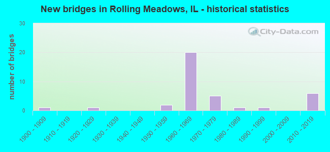
- New bridges - historical statistics
- 11900-1909
- 11920-1929
- 21950-1959
- 201960-1969
- 51970-1979
- 11980-1989
- 11990-1999
- 62010-2019

- Reconstructed bridges - Historical Statistics
- 11990-1999
- 52000-2009


- Bridge Condition - Deck
- 16.7%Very good
- 20.8%Good
- 8.3%Satisfactory
- 16.7%Fair
- 33.3%Poor
- 4.2%Critical

- Bridge Condition - Superstructure
- 25.0%Very good
- 16.7%Good
- 25.0%Satisfactory
- 12.5%Fair
- 16.7%Poor
- 4.2%Critical

- Bridge Condition - Substructure
- 12.5%Very good
- 66.7%Good
- 20.8%Satisfactory

- Bridge Condition - Channel
- 23.5%Very good
- 17.6%Good
- 29.4%Satisfactory
- 23.5%Fair
- 5.9%Poor

- Bridge Condition - Culverts
- 33.3%Satisfactory
- 66.7%Fair
Find on map >> Show street view
Structure Number: 160349, Location: 1 M E IL 53 (Lat: 42.051108, Lng: -88.009550), Route carried "on" structure: State highway 58, Year Built: 1928, Year Reconstructed: 2008, Status: Open, Structure Length: 2.10m (6.89ft), Average Daily Traffic: 30,000 (year 2021), Truck Traffic: 3%, Average Future Daily Traffic: 39,346 (year 2032), Design Load: HS 20, Features Intersected: SALT CREEK
Minimum Vertical Clearance: 30+ m (98+ ft), Kilometerpoint: 21.339, Lanes on structure: 4, Base Highway Network: Yes, Owner: State Highway Agency, Approaching Roadway Width: 12.2m (40.0ft), Skew: 32 degrees, Material/Design: Prestressed concrete, Design/Construction: Box Beam or Girders - Multiple, Number Of Spans In Main Unit: 1, Length of Maximum Span: 8.2m (26.9ft), Curb or Sidewalk Widths: Left: 0.0m, Right: 1.5m (4.9ft), Curb-To-Curb Width: 22.6m (74.1ft), Out-to-Out Width: 28.0m (91.9ft)
Condition: Deck: Good, Superstructure: Good, Substructure: Good, Channel: Very good, Operating Rating: 58.3 metric tons, Method Used To Determine Operating Rating: Load Factor (LF) rating reported by rating factor (RF) method using MS18 loading, Inventory Rating: 35.0 metric tons, Method Used To Determine Inventory Rating: Load Factor (LF) rating reported by rating factor (RF) method using MS18 loading, Structural Evaluation: Better than present minimum criteria, Deck Geometry: Superior to present desirable criteria, Waterway Adequacy: Equal to present desirable criteria, Approach Roadway Alignment: Equal to present desirable criteria, Designated Inspection Frequency: Every 48 months, Inspection Date: October 2021, Deck Structure Type: Concrete Precast Panels, Wearing Surface/Protective System: Wearing Surface: Integral Concrete, Deck Protection: Epoxy Coated Reinforcing
Find on map >> Show street view
Structure Number: 160375, Location: 0.5 M N EUCLID (Lat: 42.095617, Lng: -88.027236), Route carried "on" structure: State highway 53, Year Built: 1963, Status: Open, Structure Length: 4.74m (15.55ft), Average Daily Traffic: 103,600 (year 2021), Truck Traffic: 5%, Average Future Daily Traffic: 77,765 (year 2032), Design Load: HS 20, Features Intersected: INDUSTRIAL AVE
Minimum Vertical Clearance: 30+ m (98+ ft), Kilometerpoint: 115.998, Lanes on structure: 3, Lanes under structure: 2, Base Highway Network: Yes, Owner: State Highway Agency, Approaching Roadway Width: 16.9m (55.4ft), Skew: 3 degrees, Material/Design: Steel continuous, Design/Construction: Stringer/Multi-beam, Number Of Spans In Main Unit: 3, Length of Maximum Span: 18.0m (59.1ft), Curb-To-Curb Width: 16.9m (55.4ft), Out-to-Out Width: 18.0m (59.1ft)
Condition: Deck: Poor, Superstructure: Good, Substructure: Good, Operating Rating: 56.7 metric tons, Method Used To Determine Operating Rating: Load Factor (LF) rating reported by rating factor (RF) method using MS18 loading, Inventory Rating: 30.5 metric tons, Method Used To Determine Inventory Rating: Load Factor (LF) rating reported by rating factor (RF) method using MS18 loading, Structural Evaluation: Better than present minimum criteria, Deck Geometry: Equal to present minimum criteria, Underclear: Meets minimum limits, Approach Roadway Alignment: Equal to present desirable criteria, Designated Inspection Frequency: Every 24 months, Inspection Date: November 2021, Deck Structure Type: Concrete Cast-file-Place, Wearing Surface/Protective System: Wearing Surface: Other
Find on map >> Show street view
Structure Number: 160376, Location: 0.5 M S EUCLID (Lat: 42.082517, Lng: -88.030886), Route carried "on" structure: State highway 53, Year Built: 1963, Status: Temporarily open, Structure Length: 6.04m (19.82ft), Average Daily Traffic: 114,100 (year 2021), Truck Traffic: 5%, Average Future Daily Traffic: 90,795 (year 2032), Design Load: HS 20, Features Intersected: KIRCHOFF RD
Minimum Vertical Clearance: 30+ m (98+ ft), Kilometerpoint: 114.470, Lanes on structure: 3, Lanes under structure: 5, Base Highway Network: Yes, Owner: State Highway Agency, Approaching Roadway Width: 17.4m (57.1ft), Material/Design: Steel continuous, Design/Construction: Stringer/Multi-beam, Number Of Spans In Main Unit: 3, Length of Maximum Span: 33.5m (109.9ft), Curb-To-Curb Width: 16.8m (55.1ft), Out-to-Out Width: 18.5m (60.7ft)
Condition: Deck: Poor, Superstructure: Poor, Substructure: Good, Operating Rating: 17.2 metric tons, Method Used To Determine Operating Rating: Load Factor (LF) rating reported by rating factor (RF) method using MS18 loading, Inventory Rating: 10.4 metric tons, Method Used To Determine Inventory Rating: Load Factor (LF) rating reported by rating factor (RF) method using MS18 loading, Structural Evaluation: High priority of corrective action, Deck Geometry: Equal to present minimum criteria, Underclear: High priority of corrective action, Approach Roadway Alignment: Equal to present desirable criteria, Designated Inspection Frequency: Every 12 months, Other Special Inspection Frequency: Every 6 months, Inspection Date: August 2021, Other Special Inspection Date: August 2021, Deck Structure Type: Concrete Cast-file-Place, Wearing Surface/Protective System: Wearing Surface: Other
Find on map >> Show street view
Structure Number: 160377, Location: 0.1 M N CENTRAL (Lat: 42.068497, Lng: -88.027911), Route carried "on" structure: State highway 53, Year Built: 1962, Status: Open, Structure Length: 1.86m (6.10ft), Average Daily Traffic: 57,700 (year 2021), Truck Traffic: 13%, Average Future Daily Traffic: 170,980 (year 2032), Design Load: HS 20+Mod, Features Intersected: SALT CREEK
Minimum Vertical Clearance: 30+ m (98+ ft), Kilometerpoint: 112.860, Lanes on structure: 10, Base Highway Network: Yes, Owner: State Highway Agency, Approaching Roadway Width: 7.3m (24.0ft), Skew: 30 degrees, Material/Design: Prestressed concrete, Design/Construction: Stringer/Multi-beam, Number Of Spans In Main Unit: 1, Length of Maximum Span: 18.6m (61.0ft), Curb-To-Curb Width: 28.0m (91.9ft), Out-to-Out Width: 64.0m (210.0ft)
Condition: Deck: Fair, Superstructure: Satisfactory, Substructure: Satisfactory, Channel: Satisfactory, Operating Rating: 69.7 metric tons, Method Used To Determine Operating Rating: Load Factor (LF) rating reported by rating factor (RF) method using MS18 loading, Inventory Rating: 41.8 metric tons, Method Used To Determine Inventory Rating: Load Factor (LF) rating reported by rating factor (RF) method using MS18 loading, Structural Evaluation: Equal to present minimum criteria, Deck Geometry: High priority of replacement, Waterway Adequacy: Equal to present desirable criteria, Approach Roadway Alignment: Equal to present desirable criteria, Designated Inspection Frequency: Every 24 months, Inspection Date: November 2020, Deck Structure Type: Concrete Cast-file-Place, Wearing Surface/Protective System: Wearing Surface: Other
Find on map >> Show street view
Structure Number: 160378, Location: 0.3 M N I-90 NW TOLL (Lat: 42.062578, Lng: -88.028264), Route carried "on" structure: State highway 53, Year Built: 1962, Status: Open, Structure Length: 4.84m (15.88ft), Average Daily Traffic: 57,700 (year 2021), Truck Traffic: 13%, Average Future Daily Traffic: 99,601 (year 2032), Design Load: HS 20+Mod, Features Intersected: IL 62 ALGONQUIN RD
Minimum Vertical Clearance: 30+ m (98+ ft), Kilometerpoint: 112.200, Lanes on structure: 6, Lanes under structure: 6, Base Highway Network: Yes, Owner: State Highway Agency, Approaching Roadway Width: 18.3m (60.0ft), Skew: 31 degrees, Material/Design: Steel continuous, Design/Construction: Stringer/Multi-beam, Number Of Spans In Main Unit: 4, Length of Maximum Span: 12.5m (41.0ft), Curb-To-Curb Width: 19.8m (65.0ft), Out-to-Out Width: 38.6m (126.6ft)
Condition: Deck: Poor, Superstructure: Poor, Substructure: Good, Operating Rating: 57.0 metric tons, Method Used To Determine Operating Rating: Load Factor (LF) rating reported by rating factor (RF) method using MS18 loading, Inventory Rating: 31.4 metric tons, Method Used To Determine Inventory Rating: Load Factor (LF) rating reported by rating factor (RF) method using MS18 loading, Structural Evaluation: Meets minimum limits, Deck Geometry: High priority of replacement, Underclear: High priority of corrective action, Approach Roadway Alignment: Equal to present desirable criteria, Designated Inspection Frequency: Every 12 months, Inspection Date: September 2021, Deck Structure Type: Concrete Cast-file-Place, Wearing Surface/Protective System: Wearing Surface: Other
Find on map >> Show street view
Structure Number: 160581, Location: 0.7 M E IL 53 (Lat: 42.060356, Lng: -88.017022), Route carried "on" structure: State highway 62, Year Built: 1900, Year Reconstructed: 2011, Status: Open, Structure Length: 1.79m (5.87ft), Average Daily Traffic: 24,400 (year 2021), Truck Traffic: 4%, Average Future Daily Traffic: 29,767 (year 2032), Design Load: HS 25 or greater, Features Intersected: SALT CREEK
Minimum Vertical Clearance: 30+ m (98+ ft), Kilometerpoint: 7.210, Lanes on structure: 4, Base Highway Network: Yes, Owner: State Highway Agency, Approaching Roadway Width: 20.7m (67.9ft), Material/Design: Steel, Design/Construction: Stringer/Multi-beam, Number Of Spans In Main Unit: 1, Length of Maximum Span: 17.3m (56.8ft), Curb or Sidewalk Widths: Left: 2.5m (8.2ft), Right: 2.5m (8.2ft), Curb-To-Curb Width: 20.7m (67.9ft), Out-to-Out Width: 26.7m (87.6ft)
Condition: Deck: Good, Superstructure: Very good, Substructure: Good, Channel: Satisfactory, Operating Rating: 82.6 metric tons, Method Used To Determine Operating Rating: Load and Resistance Factor Rating (LRFR) rating reported by rating factor(RF) method using HL-93 loadings, Inventory Rating: 63.8 metric tons, Method Used To Determine Inventory Rating: Load and Resistance Factor Rating (LRFR) rating reported by rating factor(RF) method using HL-93 loadings, Structural Evaluation: Better than present minimum criteria, Deck Geometry: Superior to present desirable criteria, Waterway Adequacy: Equal to present desirable criteria, Approach Roadway Alignment: Equal to present desirable criteria, Designated Inspection Frequency: Every 48 months, Inspection Date: December 2021, Deck Structure Type: Concrete Cast-file-Place, Wearing Surface/Protective System: Deck Protection: Epoxy Coated Reinforcing
Find on map >> Show street view
Structure Number: 160977, Location: 0.5 M N IL 58 (Lat: 42.057642, Lng: -88.028544), Route carried "on" structure: Interstate 290, Year Built: 1970, Year Reconstructed: 2007, Status: Open, Structure Length: 7.86m (25.79ft), Average Daily Traffic: 69,400 (year 2021), Truck Traffic: 6%, Average Future Daily Traffic: 199,202 (year 2032), Design Load: HS 20+Mod, Features Intersected: I- 90 ADAMS TOLL
Minimum Vertical Clearance: 30+ m (98+ ft), Kilometerpoint: 0.016, Lanes on structure: 14, Lanes under structure: 12, Base Highway Network: Yes, Toll: On toll road, Owner: State Highway Agency, Approaching Roadway Width: 36.6m (120.1ft), Skew: 30 degrees, Material/Design: Steel continuous, Design/Construction: Stringer/Multi-beam, Number Of Spans In Main Unit: 2, Number Of Approach Spans: 2, Length of Maximum Span: 39.0m (128.0ft), Curb-To-Curb Width: 72.5m (237.9ft), Out-to-Out Width: 77.5m (254.3ft)
Condition: Deck: Fair, Superstructure: Satisfactory, Substructure: Satisfactory, Operating Rating: 59.6 metric tons, Method Used To Determine Operating Rating: Load Factor (LF) rating reported by rating factor (RF) method using MS18 loading, Inventory Rating: 34.0 metric tons, Method Used To Determine Inventory Rating: Load Factor (LF) rating reported by rating factor (RF) method using MS18 loading, Structural Evaluation: Equal to present minimum criteria, Deck Geometry: Superior to present desirable criteria, Underclear: High priority of corrective action, Approach Roadway Alignment: Equal to present desirable criteria, Designated Inspection Frequency: Every 24 months, Other Special Inspection Frequency: Every 72 months, Inspection Date: July 2020, Other Special Inspection Date: July 2020, Deck Structure Type: Concrete Cast-file-Place, Wearing Surface/Protective System: Wearing Surface: Latex Concrete
Find on map >> Show street view
Structure Number: 161018, Location: 3.5 M S US 12 (Lat: 42.088489, Lng: -88.031236), Route carried "on" structure: Other road , Year Built: 1963, Year Reconstructed: 1998, Status: Open, Structure Length: 7.56m (24.80ft), Average Daily Traffic: 20,600 (year 2018), Truck Traffic: 4%, Average Future Daily Traffic: 23,381 (year 2032), Design Load: HS 20, Features Intersected: IL 53, Facility Carried by Structure: EUCLID AVE
Minimum Vertical Clearance: 30+ m (98+ ft), Kilometerpoint: 2.607, Lanes on structure: 6, Lanes under structure: 8, Base Highway Network: Yes, Owner: State Highway Agency, Approaching Roadway Width: 30.5m (100.1ft), Skew: 30 degrees, Material/Design: Steel continuous, Design/Construction: Stringer/Multi-beam, Number Of Spans In Main Unit: 4, Length of Maximum Span: 22.9m (75.1ft), Curb-To-Curb Width: 25.6m (84.0ft), Out-to-Out Width: 29.2m (95.8ft)
Condition: Deck: Poor, Superstructure: Fair, Substructure: Good, Operating Rating: 50.5 metric tons, Method Used To Determine Operating Rating: Load Factor (LF) rating reported by rating factor (RF) method using MS18 loading, Inventory Rating: 30.5 metric tons, Method Used To Determine Inventory Rating: Load Factor (LF) rating reported by rating factor (RF) method using MS18 loading, Structural Evaluation: Somewhat better than minimum adequacy, Deck Geometry: Somewhat better than minimum adequacy, Underclear: Meets minimum limits, Approach Roadway Alignment: Equal to present desirable criteria, Designated Inspection Frequency: Every 24 months, Other Special Inspection Frequency: Every 48 months, Inspection Date: December 2021, Other Special Inspection Date: November 2019, Deck Structure Type: Concrete Cast-file-Place, Wearing Surface/Protective System: Wearing Surface: Latex Concrete
Find on map >> Show street view
Structure Number: 161057, Location: 0.7 M E ILL 53 P18 (Lat: 42.088439, Lng: -88.017961), Route carried "on" structure: Other road , Year Built: 1962, Status: Open, Structure Length: 1.09m (3.58ft), Average Daily Traffic: 22,200 (year 2018), Truck Traffic: 3%, Average Future Daily Traffic: 25,647 (year 2032), Design Load: HS 20, Features Intersected: SALT CREEK, Facility Carried by Structure: FAU1292 (EUCLID AV
Minimum Vertical Clearance: 30+ m (98+ ft), Kilometerpoint: 3.734, Lanes on structure: 5, Base Highway Network: Yes, Owner: County Highway Agency, Approaching Roadway Width: 18.9m (62.0ft), Skew: 20 degrees, Material/Design: Concrete continuous, Design/Construction: Culvert, Number Of Spans In Main Unit: 3, Length of Maximum Span: 3.6m (11.8ft)
Condition: Channel: Good, Culverts: Satisfactory, Operating Rating: 44.1 metric tons, Method Used To Determine Operating Rating: Load Factor (LF) rating reported by rating factor (RF) method using MS18 loading, Inventory Rating: 26.2 metric tons, Method Used To Determine Inventory Rating: Load Factor (LF) rating reported by rating factor (RF) method using MS18 loading, Structural Evaluation: Equal to present minimum criteria, Waterway Adequacy: Better than present minimum criteria, Approach Roadway Alignment: Equal to present desirable criteria, Designated Inspection Frequency: Every 24 months, Inspection Date: September 2021
Find on map >> Show street view
Structure Number: 16112, Location: 3 M S US 12 (Lat: 42.095508, Lng: -88.027347), Route carried "on" structure: State highway 53, Year Built: 1963, Status: Open, Structure Length: 4.74m (15.55ft), Average Daily Traffic: 103,600 (year 2021), Truck Traffic: 5%, Average Future Daily Traffic: 77,765 (year 2032), Design Load: HS 20, Features Intersected: INDUSTRIAL AVE
Minimum Vertical Clearance: 30+ m (98+ ft), Kilometerpoint: 115.982, Lanes on structure: 3, Lanes under structure: 2, Base Highway Network: Yes, Owner: State Highway Agency, Approaching Roadway Width: 16.9m (55.4ft), Skew: 3 degrees, Material/Design: Steel continuous, Design/Construction: Stringer/Multi-beam, Number Of Spans In Main Unit: 3, Length of Maximum Span: 18.0m (59.1ft), Curb-To-Curb Width: 16.9m (55.4ft), Out-to-Out Width: 18.0m (59.1ft)
Condition: Deck: Poor, Superstructure: Good, Substructure: Good, Operating Rating: 57.0 metric tons, Method Used To Determine Operating Rating: Load Factor (LF) rating reported by rating factor (RF) method using MS18 loading, Inventory Rating: 30.5 metric tons, Method Used To Determine Inventory Rating: Load Factor (LF) rating reported by rating factor (RF) method using MS18 loading, Structural Evaluation: Better than present minimum criteria, Deck Geometry: Equal to present minimum criteria, Underclear: Meets minimum limits, Approach Roadway Alignment: Equal to present desirable criteria, Designated Inspection Frequency: Every 24 months, Inspection Date: November 2021, Deck Structure Type: Concrete Cast-file-Place, Wearing Surface/Protective System: Wearing Surface: Other
Find on map >> Show street view
Structure Number: 161121, Location: 1.7 M N I-90 (Lat: 42.082378, Lng: -88.030844), Route carried "on" structure: State highway 53, Year Built: 1963, Status: Temporarily open, Structure Length: 6.04m (19.82ft), Average Daily Traffic: 114,100 (year 2021), Truck Traffic: 5%, Average Future Daily Traffic: 90,795 (year 2032), Design Load: HS 20, Features Intersected: KIRCHOFF RD
Minimum Vertical Clearance: 30+ m (98+ ft), Kilometerpoint: 114.453, Lanes on structure: 3, Lanes under structure: 5, Base Highway Network: Yes, Owner: State Highway Agency, Approaching Roadway Width: 15.2m (49.9ft), Skew: 4 degrees, Material/Design: Steel continuous, Design/Construction: Stringer/Multi-beam, Number Of Spans In Main Unit: 3, Length of Maximum Span: 33.5m (109.9ft), Curb-To-Curb Width: 18.0m (59.1ft), Out-to-Out Width: 18.5m (60.7ft)
Condition: Deck: Poor, Superstructure: Poor, Substructure: Good, Operating Rating: 33.0 metric tons, Method Used To Determine Operating Rating: Load Factor (LF) rating reported by rating factor (RF) method using MS18 loading, Inventory Rating: 19.8 metric tons, Method Used To Determine Inventory Rating: Load Factor (LF) rating reported by rating factor (RF) method using MS18 loading, Structural Evaluation: Meets minimum limits, Deck Geometry: Better than present minimum criteria, Underclear: High priority of corrective action, Approach Roadway Alignment: Equal to present desirable criteria, Designated Inspection Frequency: Every 12 months, Other Special Inspection Frequency: Every 6 months, Inspection Date: August 2021, Other Special Inspection Date: August 2021, Deck Structure Type: Concrete Cast-file-Place, Wearing Surface/Protective System: Wearing Surface: Other
Find on map >> Show street view
Structure Number: 161122, Location: 0.8 M N I90 P18 (Lat: 42.068931, Lng: -88.028311), Route carried "on" structure: Other road , Year Built: 1962, Year Reconstructed: 2011, Status: Open, Structure Length: 2.46m (8.07ft), Average Daily Traffic: 2,900 (year 2018), Truck Traffic: 8%, Average Future Daily Traffic: 11,433 (year 2032), Design Load: HS 20+Mod, Features Intersected: SALT CR, Facility Carried by Structure: IL 53 W FRT RD/HIC
Minimum Vertical Clearance: 30+ m (98+ ft), Kilometerpoint: 4.812, Lanes on structure: 2, Owner: City or Municipal Highway Agency, Approaching Roadway Width: 9.2m (30.2ft), Skew: 3 degrees, Material/Design: Prestressed concrete, Design/Construction: Stringer/Multi-beam, Number Of Spans In Main Unit: 1, Length of Maximum Span: 23.8m (78.1ft), Curb or Sidewalk Widths: Left: 0.0m, Right: 1.5m (4.9ft), Curb-To-Curb Width: 9.0m (29.5ft), Out-to-Out Width: 11.3m (37.1ft)
Condition: Deck: Good, Superstructure: Satisfactory, Substructure: Good, Channel: Fair, Operating Rating: 89.1 metric tons, Method Used To Determine Operating Rating: Load Factor (LF) rating reported by rating factor (RF) method using MS18 loading, Inventory Rating: 43.7 metric tons, Method Used To Determine Inventory Rating: Load Factor (LF) rating reported by rating factor (RF) method using MS18 loading, Structural Evaluation: Equal to present minimum criteria, Deck Geometry: Meets minimum limits, Waterway Adequacy: Equal to present desirable criteria, Approach Roadway Alignment: Equal to present desirable criteria, Length Of Structure Improvement: 2.74m (8.99ft), Designated Inspection Frequency: Every 24 months, Inspection Date: October 2020, Bridge Improvement Cost: $308,000, Roadway Improvement Cost: $31,000, Total Project Cost: $462,000, Deck Structure Type: Concrete Cast-file-Place, Wearing Surface/Protective System: Deck Protection: Epoxy Coated Reinforcing
Find on map >> Show street view
Structure Number: 161123, Location: NORTH OF IL-62 (Lat: 42.068903, Lng: -88.027150), Route carried "on" structure: Other road , Year Built: 1962, Year Reconstructed: 2011, Status: Open, Structure Length: 1.86m (6.10ft), Average Daily Traffic: 1,950 (year 2018), Truck Traffic: 5%, Average Future Daily Traffic: 192,301 (year 2032), Design Load: HS 20+Mod, Features Intersected: SALT CREEK, Facility Carried by Structure: IL 53E FRONTAGE RD
Minimum Vertical Clearance: 30+ m (98+ ft), Kilometerpoint: 1.464, Lanes on structure: 2, Owner: City or Municipal Highway Agency, Approaching Roadway Width: 9.2m (30.2ft), Material/Design: Prestressed concrete, Design/Construction: Stringer/Multi-beam, Number Of Spans In Main Unit: 1, Length of Maximum Span: 18.6m (61.0ft), Curb or Sidewalk Widths: Left: 1.5m (4.9ft), Right: 0.0m, Curb-To-Curb Width: 9.0m (29.5ft), Out-to-Out Width: 11.3m (37.1ft)
Condition: Deck: Good, Superstructure: Satisfactory, Substructure: Good, Channel: Fair, Operating Rating: 89.1 metric tons, Method Used To Determine Operating Rating: Load Factor (LF) rating reported by rating factor (RF) method using MS18 loading, Inventory Rating: 50.5 metric tons, Method Used To Determine Inventory Rating: Load Factor (LF) rating reported by rating factor (RF) method using MS18 loading, Structural Evaluation: Equal to present minimum criteria, Deck Geometry: Somewhat better than minimum adequacy, Waterway Adequacy: Equal to present desirable criteria, Approach Roadway Alignment: Equal to present desirable criteria, Length Of Structure Improvement: 2.74m (8.99ft), Designated Inspection Frequency: Every 24 months, Inspection Date: October 2020, Bridge Improvement Cost: $304,000, Roadway Improvement Cost: $30,000, Total Project Cost: $456,000, Deck Structure Type: Concrete Cast-file-Place, Wearing Surface/Protective System: Deck Protection: Epoxy Coated Reinforcing
Find on map >> Show street view
Structure Number: 162133, Location: 0.3 M N I-90 (Lat: 42.062469, Lng: -88.028269), Route carried "on" structure: State highway 53, Year Built: 1962, Status: Open, Structure Length: 4.94m (16.21ft), Average Daily Traffic: 57,700 (year 2021), Truck Traffic: 13%, Average Future Daily Traffic: 99,601 (year 2032), Design Load: HS 20+Mod, Features Intersected: IL 62 FAP 339
Minimum Vertical Clearance: 30+ m (98+ ft), Kilometerpoint: 112.184, Lanes on structure: 5, Lanes under structure: 6, Base Highway Network: Yes, Owner: State Highway Agency, Approaching Roadway Width: 37.8m (124.0ft), Skew: 31 degrees, Material/Design: Steel continuous, Design/Construction: Stringer/Multi-beam, Number Of Spans In Main Unit: 4, Length of Maximum Span: 12.6m (41.3ft), Curb-To-Curb Width: 37.7m (123.7ft), Out-to-Out Width: 39.7m (130.2ft)
Condition: Deck: Poor, Superstructure: Poor, Substructure: Satisfactory, Operating Rating: 45.0 metric tons, Method Used To Determine Operating Rating: Load Factor (LF) rating reported by rating factor (RF) method using MS18 loading, Inventory Rating: 26.9 metric tons, Method Used To Determine Inventory Rating: Load Factor (LF) rating reported by rating factor (RF) method using MS18 loading, Structural Evaluation: Meets minimum limits, Deck Geometry: Superior to present desirable criteria, Underclear: Meets minimum limits, Approach Roadway Alignment: Equal to present desirable criteria, Designated Inspection Frequency: Every 12 months, Inspection Date: September 2021, Deck Structure Type: Concrete Cast-file-Place, Wearing Surface/Protective System: Wearing Surface: Other
Find on map >> Show street view
Structure Number: 163048, Location: 0.4 M N ILL 62 P18 (Lat: 42.077158, Lng: -88.053506), Route carried "on" structure: City street , Year Built: 1957, Status: Open, Structure Length: 1.73m (5.68ft), Average Daily Traffic: 2,300 (year 2018), Truck Traffic: 3%, Average Future Daily Traffic: 3,202 (year 2032), Design Load: HS 20, Features Intersected: SALT CREEK, Facility Carried by Structure: PLUM GROVE RD
Minimum Vertical Clearance: 30+ m (98+ ft), Kilometerpoint: 1.094, Lanes on structure: 2, Owner: County Highway Agency, Approaching Roadway Width: 7.3m (24.0ft), Material/Design: Steel, Design/Construction: Stringer/Multi-beam, Number Of Spans In Main Unit: 1, Length of Maximum Span: 16.2m (53.1ft), Curb or Sidewalk Widths: Left: 1.2m (3.9ft), Right: 1.2m (3.9ft), Curb-To-Curb Width: 7.9m (25.9ft), Out-to-Out Width: 11.0m (36.1ft)
Condition: Deck: Fair, Superstructure: Good, Substructure: Good, Channel: Satisfactory, Operating Rating: 53.8 metric tons, Method Used To Determine Operating Rating: Load Factor (LF) rating reported by rating factor (RF) method using MS18 loading, Inventory Rating: 32.1 metric tons, Method Used To Determine Inventory Rating: Load Factor (LF) rating reported by rating factor (RF) method using MS18 loading, Structural Evaluation: Better than present minimum criteria, Deck Geometry: High priority of corrective action, Waterway Adequacy: Equal to present minimum criteria, Approach Roadway Alignment: Equal to present minimum criteria, Designated Inspection Frequency: Every 24 months, Inspection Date: July 2020, Deck Structure Type: Concrete Cast-file-Place, Wearing Surface/Protective System: Wearing Surface: Latex Concrete
Find on map >> Show street view
Structure Number: 164, Location: 0.5 E PLUM GR P18 (Lat: 42.071161, Lng: -88.034772), Route carried "on" structure: County highway , Year Built: 1954, Status: Open, Structure Length: 1.25m (4.10ft), Average Daily Traffic: 700 (year 2018), Truck Traffic: 11%, Average Future Daily Traffic: 670 (year 2032), Features Intersected: SALT CR, Facility Carried by Structure: BRIARWOOD LANE
Minimum Vertical Clearance: 30+ m (98+ ft), Kilometerpoint: 0.805, Lanes on structure: 2, Owner: Town or Township Highway Agency, Approaching Roadway Width: 6.1m (20.0ft), Material/Design: Concrete, Design/Construction: Culvert, Number Of Spans In Main Unit: 3, Length of Maximum Span: 3.7m (12.1ft), Curb-To-Curb Width: 6.1m (20.0ft), Out-to-Out Width: 8.4m (27.6ft)
Condition: Channel: Satisfactory, Culverts: Fair, Operating Rating: 40.5 metric tons, Method Used To Determine Operating Rating: Field evaluation and documented engineering judgment, Inventory Rating: 24.3 metric tons, Method Used To Determine Inventory Rating: Field evaluation and documented engineering judgment, Structural Evaluation: Somewhat better than minimum adequacy, Deck Geometry: High priority of corrective action, Waterway Adequacy: Better than present minimum criteria, Approach Roadway Alignment: Equal to present minimum criteria, Designated Inspection Frequency: Every 24 months, Inspection Date: June 2020, Deck Structure Type: Concrete Cast-file-Place, Wearing Surface/Protective System: Wearing Surface: Bituminous
Find on map >> Show street view
Structure Number: 166055, Location: 0.4 N 62/.6 E 53 P5 (Lat: 42.063444, Lng: -88.019308), Route carried "on" structure: City street , Year Built: 1970, Status: Open, Structure Length: 1.34m (4.40ft), Average Daily Traffic: 2,300 (year 2018), Truck Traffic: 10%, Average Future Daily Traffic: 3,399 (year 2032), Design Load: HS 25 or greater, Features Intersected: SALT CREEK, Facility Carried by Structure: BARKER AVE
Minimum Vertical Clearance: 30+ m (98+ ft), Kilometerpoint: 0.322, Lanes on structure: 2, Owner: City or Municipal Highway Agency, Approaching Roadway Width: 10.5m (34.4ft), Material/Design: Prestressed concrete, Design/Construction: Box Beam or Girders - Multiple, Number Of Spans In Main Unit: 1, Length of Maximum Span: 12.7m (41.7ft), Curb or Sidewalk Widths: Left: 1.5m (4.9ft), Right: 1.5m (4.9ft), Curb-To-Curb Width: 10.5m (34.4ft), Out-to-Out Width: 14.1m (46.3ft)
Condition: Deck: Very good, Superstructure: Very good, Substructure: Good, Channel: Fair, Operating Rating: 50.5 metric tons, Method Used To Determine Operating Rating: Load and Resistance Factor Rating (LRFR) rating reported by rating factor(RF) method using HL-93 loadings, Inventory Rating: 39.5 metric tons, Method Used To Determine Inventory Rating: Load and Resistance Factor Rating (LRFR) rating reported by rating factor(RF) method using HL-93 loadings, Structural Evaluation: Better than present minimum criteria, Deck Geometry: Somewhat better than minimum adequacy, Waterway Adequacy: Superior to present desirable criteria, Approach Roadway Alignment: Equal to present desirable criteria, Designated Inspection Frequency: Every 24 months, Inspection Date: October 2021, Deck Structure Type: Concrete Precast Panels, Wearing Surface/Protective System: Deck Protection: Epoxy Coated Reinforcing
Find on map >> Show street view
Structure Number: 166061, Location: 0.15 E ILL 53 P5,18 (Lat: 42.066733, Lng: -88.024392), Route carried "on" structure: Other road , Year Built: 1960, Status: Open, Structure Length: 0.85m (2.79ft), Average Daily Traffic: 3,700 (year 2018), Truck Traffic: 8%, Average Future Daily Traffic: 18,025 (year 2032), Design Load: H 20, Features Intersected: W BR SALT CREEK, Facility Carried by Structure: CENTRAL RD
Minimum Vertical Clearance: 30+ m (98+ ft), Kilometerpoint: 0.225, Lanes on structure: 2, Owner: City or Municipal Highway Agency, Approaching Roadway Width: 10.1m (33.1ft), Skew: 1 degrees, Material/Design: Concrete, Design/Construction: Slab, Number Of Spans In Main Unit: 1, Length of Maximum Span: 8.2m (26.9ft), Curb or Sidewalk Widths: Left: 1.6m (5.2ft), Right: 1.6m (5.2ft), Curb-To-Curb Width: 10.4m (34.1ft), Out-to-Out Width: 14.1m (46.3ft)
Condition: Deck: Poor, Superstructure: Fair, Substructure: Satisfactory, Channel: Satisfactory, Operating Rating: 50.5 metric tons, Method Used To Determine Operating Rating: Load Factor (LF) rating reported by rating factor (RF) method using MS18 loading, Inventory Rating: 30.5 metric tons, Method Used To Determine Inventory Rating: Load Factor (LF) rating reported by rating factor (RF) method using MS18 loading, Structural Evaluation: Somewhat better than minimum adequacy, Deck Geometry: Somewhat better than minimum adequacy, Waterway Adequacy: Better than present minimum criteria, Approach Roadway Alignment: Better than present minimum criteria, Designated Inspection Frequency: Every 24 months, Inspection Date: October 2021, Deck Structure Type: Concrete Cast-file-Place, Wearing Surface/Protective System: Wearing Surface: Bituminous
Find on map >> Show street view
Structure Number: 166088, Location: 0.6 E 53/2.4 N 62P18 (Lat: 42.084036, Lng: -88.018131), Route carried "on" structure: City street , Year Built: 1970, Status: Open, Structure Length: 1.01m (3.31ft), Average Daily Traffic: 2,400 (year 2018), Truck Traffic: 5%, Average Future Daily Traffic: 215 (year 2032), Design Load: HS 20, Features Intersected: SALT CREEK, Facility Carried by Structure: CAMPBELL
Minimum Vertical Clearance: 30+ m (98+ ft), Kilometerpoint: 0.756, Lanes on structure: 2, Owner: City or Municipal Highway Agency, Approaching Roadway Width: 9.1m (29.9ft), Skew: 2 degrees, Material/Design: Concrete, Design/Construction: Culvert, Number Of Spans In Main Unit: 2, Length of Maximum Span: 4.9m (16.1ft), Curb or Sidewalk Widths: Left: 1.5m (4.9ft), Right: 1.5m (4.9ft), Curb-To-Curb Width: 10.4m (34.1ft), Out-to-Out Width: 14.0m (45.9ft)
Condition: Channel: Fair, Culverts: Fair, Operating Rating: 50.9 metric tons, Method Used To Determine Operating Rating: Load Factor (LF) rating reported by rating factor (RF) method using MS18 loading, Inventory Rating: 30.5 metric tons, Method Used To Determine Inventory Rating: Load Factor (LF) rating reported by rating factor (RF) method using MS18 loading, Structural Evaluation: Somewhat better than minimum adequacy, Deck Geometry: Somewhat better than minimum adequacy, Waterway Adequacy: Equal to present desirable criteria, Approach Roadway Alignment: Equal to present desirable criteria, Designated Inspection Frequency: Every 24 months, Inspection Date: October 2021, Deck Structure Type: Concrete Cast-file-Place, Wearing Surface/Protective System: Wearing Surface: Bituminous
Find on map >> Show street view
Structure Number: 166321, Location: 0.4 M E ILL 53 P5 (Lat: 42.066717, Lng: -88.018561), Route carried "on" structure: Other road , Year Built: 1962, Status: Open, Structure Length: 0.85m (2.79ft), Average Daily Traffic: 3,700 (year 2018), Truck Traffic: 8%, Average Future Daily Traffic: 18,025 (year 2032), Design Load: H 20, Features Intersected: SALT CREEK, Facility Carried by Structure: CENTRAL RD
Minimum Vertical Clearance: 30+ m (98+ ft), Kilometerpoint: 0.708, Lanes on structure: 2, Owner: City or Municipal Highway Agency, Approaching Roadway Width: 10.4m (34.1ft), Material/Design: Concrete, Design/Construction: Slab, Number Of Spans In Main Unit: 1, Length of Maximum Span: 8.2m (26.9ft), Curb or Sidewalk Widths: Left: 1.6m (5.2ft), Right: 1.6m (5.2ft), Curb-To-Curb Width: 10.4m (34.1ft), Out-to-Out Width: 14.1m (46.3ft)
Condition: Deck: Satisfactory, Superstructure: Satisfactory, Substructure: Satisfactory, Channel: Poor, Operating Rating: 46.3 metric tons, Method Used To Determine Operating Rating: Load Factor (LF) rating reported by rating factor (RF) method using MS18 loading, Inventory Rating: 27.9 metric tons, Method Used To Determine Inventory Rating: Load Factor (LF) rating reported by rating factor (RF) method using MS18 loading, Structural Evaluation: Equal to present minimum criteria, Deck Geometry: Somewhat better than minimum adequacy, Waterway Adequacy: Better than present minimum criteria, Approach Roadway Alignment: Equal to present minimum criteria, Designated Inspection Frequency: Every 24 months, Inspection Date: October 2021, Deck Structure Type: Concrete Cast-file-Place, Wearing Surface/Protective System: Wearing Surface: Bituminous
Find on map >> Show street view
Structure Number: 166322, Location: 2 E 53/.5 S 62 P5C (Lat: 42.054994, Lng: -88.009558), Route carried "on" structure: City street , Year Built: 1978, Status: Temporarily open, Structure Length: 1.95m (6.40ft), Average Daily Traffic: 1,250 (year 2018), Truck Traffic: 18%, Average Future Daily Traffic: 215 (year 2032), Design Load: HS 20, Features Intersected: SALT CREEK, Facility Carried by Structure: MEADOWBROOK
Minimum Vertical Clearance: 30+ m (98+ ft), Kilometerpoint: 0.402, Lanes on structure: 2, Owner: City or Municipal Highway Agency, Approaching Roadway Width: 7.3m (24.0ft), Material/Design: Prestressed concrete, Design/Construction: Box Beam or Girders - Multiple, Number Of Spans In Main Unit: 1, Length of Maximum Span: 18.6m (61.0ft), Curb or Sidewalk Widths: Left: 1.5m (4.9ft), Right: 0.0m, Curb-To-Curb Width: 7.3m (24.0ft), Out-to-Out Width: 9.6m (31.5ft)
Condition: Deck: Critical, Superstructure: Critical, Substructure: Good, Channel: Good, Operating Rating: 38.6 metric tons, Method Used To Determine Operating Rating: Load Factor (LF) rating reported by rating factor (RF) method using MS18 loading, Structural Evaluation: High priority of replacement, Deck Geometry: Meets minimum limits, Waterway Adequacy: Equal to present desirable criteria, Approach Roadway Alignment: Equal to present desirable criteria, Designated Inspection Frequency: Every 24 months, Inspection Date: September 2021, Deck Structure Type: Concrete Precast Panels, Wearing Surface/Protective System: Wearing Surface: Bituminous
Find on map >> Show street view
Structure Number: 166323, Location: 2 E 53/ .25 N 58 P5C (Lat: 42.054036, Lng: -88.008903), Route carried "on" structure: City street , Year Built: 1982, Status: Open, Structure Length: 1.94m (6.36ft), Average Daily Traffic: 1,700 (year 2018), Truck Traffic: 8%, Average Future Daily Traffic: 215 (year 2032), Design Load: HS 20, Features Intersected: SALT CREEK, Facility Carried by Structure: LOIS DR
Minimum Vertical Clearance: 30+ m (98+ ft), Kilometerpoint: 0.048, Lanes on structure: 2, Owner: City or Municipal Highway Agency, Approaching Roadway Width: 9.7m (31.8ft), Material/Design: Prestressed concrete, Design/Construction: Box Beam or Girders - Multiple, Number Of Spans In Main Unit: 1, Length of Maximum Span: 18.6m (61.0ft), Curb or Sidewalk Widths: Left: 0.0m, Right: 1.7m (5.6ft), Curb-To-Curb Width: 9.7m (31.8ft), Out-to-Out Width: 12.1m (39.7ft)
Condition: Deck: Satisfactory, Superstructure: Satisfactory, Substructure: Good, Channel: Good, Operating Rating: 44.4 metric tons, Method Used To Determine Operating Rating: Allowable Stress (AS) rating reported by rating factor (RF) method using MS18 loading, Inventory Rating: 32.4 metric tons, Method Used To Determine Inventory Rating: Allowable Stress (AS) rating reported by rating factor (RF) method using MS18 loading, Structural Evaluation: Equal to present minimum criteria, Deck Geometry: Somewhat better than minimum adequacy, Waterway Adequacy: Equal to present desirable criteria, Approach Roadway Alignment: Equal to present desirable criteria, Designated Inspection Frequency: Every 24 months, Inspection Date: September 2021, Deck Structure Type: Concrete Precast Panels, Wearing Surface/Protective System: Wearing Surface: Bituminous
Find on map >> Show street view
Structure Number: 167925, Location: 0.4M SE IL 53 (Lat: 42.078975, Lng: -88.022428), Route carried "on" structure: Other road , Year Built: 1996, Status: Open, Structure Length: 1.23m (4.04ft), Average Daily Traffic: 11,200 (year 2018), Truck Traffic: 5%, Average Future Daily Traffic: 11,948 (year 2032), Design Load: HS 20, Features Intersected: SALT CREEK, Facility Carried by Structure: KIRCHOFF RD
Minimum Vertical Clearance: 30+ m (98+ ft), Kilometerpoint: 1.963, Lanes on structure: 4, Base Highway Network: Yes, Owner: City or Municipal Highway Agency, Approaching Roadway Width: 19.9m (65.3ft), Material/Design: Prestressed concrete, Design/Construction: Box Beam or Girders - Multiple, Number Of Spans In Main Unit: 1, Length of Maximum Span: 11.4m (37.4ft), Curb or Sidewalk Widths: Left: 3.3m (10.8ft), Right: 3.3m (10.8ft), Curb-To-Curb Width: 19.9m (65.3ft), Out-to-Out Width: 28.1m (92.2ft)
Condition: Deck: Fair, Superstructure: Fair, Substructure: Good, Channel: Very good, Operating Rating: 93.6 metric tons, Method Used To Determine Operating Rating: Load Factor (LF) rating reported by rating factor (RF) method using MS18 loading, Inventory Rating: 56.1 metric tons, Method Used To Determine Inventory Rating: Load Factor (LF) rating reported by rating factor (RF) method using MS18 loading, Structural Evaluation: Somewhat better than minimum adequacy, Deck Geometry: Better than present minimum criteria, Waterway Adequacy: Superior to present desirable criteria, Approach Roadway Alignment: Equal to present desirable criteria, Designated Inspection Frequency: Every 24 months, Inspection Date: September 2021, Deck Structure Type: Concrete Precast Panels, Wearing Surface/Protective System: Wearing Surface: Bituminous, Membrane: Built-up
Find on map >> Show street view
Structure Number: 169603, Location: 1 Mi E. Ill Rte 53 (Lat: 42.053122, Lng: -88.011000), Route carried "on" structure: Interstate 90, Year Built: 2015, Status: Open, Structure Length: 2.82m (9.25ft), Average Daily Traffic: 57,950 (year 2020), Truck Traffic: 9%, Average Future Daily Traffic: 67,002 (year 2032), Design Load: HS 25 or greater, Features Intersected: Salt Creek
Minimum Vertical Clearance: 30+ m (98+ ft), Kilometerpoint: 111.557, Lanes on structure: 3, Base Highway Network: Yes, Toll: On toll road, Owner: State Toll Authority, Approaching Roadway Width: 27.7m (90.9ft), Material/Design: Prestressed concrete, Design/Construction: Stringer/Multi-beam, Number Of Spans In Main Unit: 1, Length of Maximum Span: 27.1m (88.9ft), Curb-To-Curb Width: 27.7m (90.9ft), Out-to-Out Width: 28.7m (94.2ft)
Condition: Deck: Very good, Superstructure: Very good, Substructure: Very good, Channel: Very good, Operating Rating: 57.0 metric tons, Method Used To Determine Operating Rating: Load and Resistance Factor Rating (LRFR) rating reported by rating factor(RF) method using HL-93 loadings, Inventory Rating: 49.2 metric tons, Method Used To Determine Inventory Rating: Load and Resistance Factor Rating (LRFR) rating reported by rating factor(RF) method using HL-93 loadings, Structural Evaluation: Equal to present desirable criteria, Deck Geometry: Superior to present desirable criteria, Waterway Adequacy: Superior to present desirable criteria, Approach Roadway Alignment: Equal to present desirable criteria, Designated Inspection Frequency: Every 24 months, Inspection Date: May 2019, Deck Structure Type: Concrete Cast-file-Place, Wearing Surface/Protective System: Deck Protection: Epoxy Coated Reinforcing
Find on map >> Show street view
Structure Number: 169604, Location: 1.2 Mi E. Ill Rte 53 (Lat: 42.051158, Lng: -88.006778), Route carried "on" structure: Interstate 90, Year Built: 2015, Status: Open, Structure Length: 7.86m (25.79ft), Average Daily Traffic: 115,900 (year 2020), Truck Traffic: 9%, Average Future Daily Traffic: 67,002 (year 2032), Design Load: HS 25 or greater, Features Intersected: Golf Road
Minimum Vertical Clearance: 30+ m (98+ ft), Kilometerpoint: 111.766, Lanes on structure: 5, Lanes under structure: 4, Base Highway Network: Yes, Toll: On toll road, Owner: State Toll Authority, Approaching Roadway Width: 27.7m (90.9ft), Skew: 5 degrees, Material/Design: Prestressed concrete continuous, Design/Construction: Stringer/Multi-beam, Number Of Spans In Main Unit: 2, Length of Maximum Span: 38.0m (124.7ft), Curb-To-Curb Width: 27.7m (90.9ft), Out-to-Out Width: 28.7m (94.2ft)
Condition: Deck: Very good, Superstructure: Very good, Substructure: Very good, Operating Rating: 53.1 metric tons, Method Used To Determine Operating Rating: Load and Resistance Factor Rating (LRFR) rating reported by rating factor(RF) method using HL-93 loadings, Inventory Rating: 40.8 metric tons, Method Used To Determine Inventory Rating: Load and Resistance Factor Rating (LRFR) rating reported by rating factor(RF) method using HL-93 loadings, Structural Evaluation: Equal to present desirable criteria, Deck Geometry: Superior to present desirable criteria, Approach Roadway Alignment: Equal to present desirable criteria, Designated Inspection Frequency: Every 24 months, Inspection Date: August 2019, Deck Structure Type: Concrete Cast-file-Place, Wearing Surface/Protective System: Deck Protection: Epoxy Coated Reinforcing
Find on map >> Show street view
Structure Number: 169614, Location: 1 Mi E. Ill Rte 53 (Lat: 42.052978, Lng: -88.010686), Route carried "on" structure: Interstate 90, Year Built: 2015, Status: Open, Structure Length: 2.82m (9.25ft), Average Daily Traffic: 115,900 (year 2020), Truck Traffic: 9%, Average Future Daily Traffic: 67,002 (year 2032), Design Load: HS 25 or greater, Features Intersected: Salt Creek
Minimum Vertical Clearance: 30+ m (98+ ft), Kilometerpoint: 111.573, Lanes on structure: 5, Base Highway Network: Yes, Toll: On toll road, Owner: State Toll Authority, Approaching Roadway Width: 27.7m (90.9ft), Material/Design: Prestressed concrete, Design/Construction: Stringer/Multi-beam, Number Of Spans In Main Unit: 1, Length of Maximum Span: 27.1m (88.9ft), Curb-To-Curb Width: 27.7m (90.9ft), Out-to-Out Width: 28.7m (94.2ft)
Condition: Deck: Good, Superstructure: Very good, Substructure: Very good, Channel: Very good, Operating Rating: 68.4 metric tons, Method Used To Determine Operating Rating: Load and Resistance Factor Rating (LRFR) rating reported by rating factor(RF) method using HL-93 loadings, Inventory Rating: 49.2 metric tons, Method Used To Determine Inventory Rating: Load and Resistance Factor Rating (LRFR) rating reported by rating factor(RF) method using HL-93 loadings, Structural Evaluation: Equal to present desirable criteria, Deck Geometry: Superior to present desirable criteria, Waterway Adequacy: Superior to present desirable criteria, Approach Roadway Alignment: Equal to present desirable criteria, Designated Inspection Frequency: Every 24 months, Inspection Date: May 2019, Deck Structure Type: Concrete Cast-file-Place, Wearing Surface/Protective System: Deck Protection: Epoxy Coated Reinforcing
Find on map >> Show street view
Structure Number: 169615, Location: 1.2 Mi E. Ill Rte 53 (Lat: 42.051375, Lng: -88.007242), Route carried "on" structure: Interstate 90, Year Built: 2015, Status: Open, Structure Length: 7.86m (25.79ft), Average Daily Traffic: 115,900 (year 2020), Truck Traffic: 9%, Average Future Daily Traffic: 67,002 (year 2032), Design Load: HS 25 or greater, Features Intersected: Golf Road
Minimum Vertical Clearance: 30+ m (98+ ft), Kilometerpoint: 111.734, Lanes on structure: 5, Lanes under structure: 4, Base Highway Network: Yes, Toll: On toll road, Owner: State Toll Authority, Approaching Roadway Width: 27.7m (90.9ft), Skew: 5 degrees, Material/Design: Prestressed concrete continuous, Design/Construction: Stringer/Multi-beam, Number Of Spans In Main Unit: 2, Length of Maximum Span: 38.0m (124.7ft), Curb-To-Curb Width: 27.7m (90.9ft), Out-to-Out Width: 28.7m (94.2ft)
Condition: Deck: Very good, Superstructure: Very good, Substructure: Good, Operating Rating: 53.1 metric tons, Method Used To Determine Operating Rating: Load and Resistance Factor Rating (LRFR) rating reported by rating factor(RF) method using HL-93 loadings, Inventory Rating: 40.8 metric tons, Method Used To Determine Inventory Rating: Load and Resistance Factor Rating (LRFR) rating reported by rating factor(RF) method using HL-93 loadings, Structural Evaluation: Better than present minimum criteria, Deck Geometry: Superior to present desirable criteria, Approach Roadway Alignment: Equal to present desirable criteria, Designated Inspection Frequency: Every 24 months, Inspection Date: August 2019, Deck Structure Type: Concrete Cast-file-Place, Wearing Surface/Protective System: Deck Protection: Epoxy Coated Reinforcing
Find on map >> Show street view
Structure Number: 160375, Location: 0.5 M N EUCLID (Lat: 42.095617, Lng: -88.027328), Route carried "under" structure: Other road , Year Built: 1963, Structure Length: 0. m, Average Daily Traffic: 5,300 (year 2018), Truck Traffic: 7%, Features Intersected: INDUSTRIAL AVE, Facility Carried by Structure: IL 53 NB
Minimum Vertical Clearance: 4.60m (15.09ft), Kilometerpoint: 0.032, Lanes on structure: 3, Lanes under structure: 2, Material/Design: Steel continuous, Design/Construction: Stringer/Multi-beam, Length of Maximum Span: 18.0m (59.1ft)
Find on map >> Show street view
Structure Number: 160376, Location: 0.5 M S EUCLID (Lat: 42.082397, Lng: -88.030608), Route carried "under" structure: Other road , Year Built: 1963, Structure Length: 0. m, Average Daily Traffic: 8,800 (year 2018), Truck Traffic: 8%, Features Intersected: KIRCHOFF RD, Facility Carried by Structure: IL 53 NB
Minimum Vertical Clearance: 4.62m (15.16ft), Kilometerpoint: 1.207, Lanes on structure: 3, Lanes under structure: 5, Material/Design: Steel continuous, Design/Construction: Stringer/Multi-beam, Length of Maximum Span: 33.5m (109.9ft)
Find on map >> Show street view
Structure Number: 160378, Location: 0.3 M N I-90 NW TOLL (Lat: 42.062578, Lng: -88.028264), Route carried "under" structure: State highway 62, Year Built: 1962, Structure Length: 0. m, Average Daily Traffic: 24,400 (year 2021), Truck Traffic: 4%, Features Intersected: IL 62 ALGONQUIN RD, Facility Carried by Structure: IL 53 NB
Minimum Vertical Clearance: 4.57m (14.99ft), Kilometerpoint: 8.191, Lanes on structure: 6, Lanes under structure: 6, Material/Design: Steel continuous, Design/Construction: Stringer/Multi-beam, Length of Maximum Span: 12.5m (41.0ft)
Find on map >> Show street view
Structure Number: 160977, Location: 0.5 M N IL 58 (Lat: 42.057492, Lng: -88.028542), Route carried "under" structure: Interstate 90, Year Built: 1970, Structure Length: 0. m, Average Daily Traffic: 115,900 (year 2020), Truck Traffic: 9%, Features Intersected: I- 90 ADAMS TOLL
Minimum Vertical Clearance: 5.05m (16.57ft), Kilometerpoint: 109.819, Lanes on structure: 14, Lanes under structure: 12, Toll: On toll road, Material/Design: Steel continuous, Design/Construction: Stringer/Multi-beam, Length of Maximum Span: 39.0m (128.0ft)
Find on map >> Show street view
Structure Number: 161018, Location: 3.5 M S US 12 (Lat: 42.088489, Lng: -88.031133), Route carried "under" structure: State highway 53, Year Built: 1963, Structure Length: 0. m, Average Daily Traffic: 108,400 (year 2021), Truck Traffic: 5%, Features Intersected: IL 53, Facility Carried by Structure: EUCLID AVE
Minimum Vertical Clearance: 5.38m (17.65ft), Kilometerpoint: 115.081, Lanes on structure: 6, Lanes under structure: 8, Material/Design: Steel continuous, Design/Construction: Stringer/Multi-beam, Length of Maximum Span: 22.9m (75.1ft)
Find on map >> Show street view
Structure Number: 16112, Location: 3 M S US 12 (Lat: 42.095617, Lng: -88.027236), Route carried "under" structure: Other road , Year Built: 1963, Structure Length: 0. m, Average Daily Traffic: 5,300 (year 2018), Truck Traffic: 7%, Features Intersected: INDUSTRIAL AVE, Facility Carried by Structure: IL 53 SB
Minimum Vertical Clearance: 4.60m (15.09ft), Kilometerpoint: 0.048, Lanes on structure: 3, Lanes under structure: 2, Material/Design: Steel continuous, Design/Construction: Stringer/Multi-beam, Length of Maximum Span: 18.0m (59.1ft)
Find on map >> Show street view
Structure Number: 161121, Location: 1.7 M N I-90 (Lat: 42.082550, Lng: -88.030972), Route carried "under" structure: Other road , Year Built: 1963, Structure Length: 0. m, Average Daily Traffic: 8,800 (year 2018), Truck Traffic: 8%, Features Intersected: KIRCHOFF RD, Facility Carried by Structure: IL 53 SB
Minimum Vertical Clearance: 4.45m (14.60ft), Kilometerpoint: 1.175, Lanes on structure: 3, Lanes under structure: 5, Material/Design: Steel continuous, Design/Construction: Stringer/Multi-beam, Length of Maximum Span: 33.5m (109.9ft)
Find on map >> Show street view
Structure Number: 162133, Location: 0.3 M N I-90 (Lat: 42.062617, Lng: -88.028442), Route carried "under" structure: State highway 62, Year Built: 1962, Structure Length: 0. m, Average Daily Traffic: 33,000 (year 2019), Truck Traffic: 6%, Features Intersected: IL 62 FAP 339, Facility Carried by Structure: IL 53 SB FAP 342
Minimum Vertical Clearance: 4.42m (14.50ft), Kilometerpoint: 8.207, Lanes on structure: 5, Lanes under structure: 6, Material/Design: Steel continuous, Design/Construction: Stringer/Multi-beam, Length of Maximum Span: 12.6m (41.3ft)
Find on map >> Show street view
Structure Number: 169604, Location: 1.2 Mi E. Ill Rte 53 (Lat: 42.051158, Lng: -88.006778), Route carried "under" structure: State highway 58, Year Built: 2015, Structure Length: 0. m, Average Daily Traffic: 26,300 (year 2021), Truck Traffic: 3%, Features Intersected: Golf Road, Facility Carried by Structure: I-90 WB Jayne Adam
Minimum Vertical Clearance: 4.57m (14.99ft), Kilometerpoint: 21.549, Lanes on structure: 5, Lanes under structure: 4, Toll: On toll road, Material/Design: Prestressed concrete continuous, Design/Construction: Stringer/Multi-beam, Length of Maximum Span: 38.0m (124.7ft)
Find on map >> Show street view
Structure Number: 169615, Location: 1.2 Mi E. Ill Rte 53 (Lat: 42.051167, Lng: -88.006317), Route carried "under" structure: State highway 58, Year Built: 2015, Structure Length: 0. m, Average Daily Traffic: 26,300 (year 2021), Truck Traffic: 3%, Features Intersected: Golf Road, Facility Carried by Structure: I-90 EB
Minimum Vertical Clearance: 4.55m (14.93ft), Kilometerpoint: 21.581, Lanes on structure: 5, Lanes under structure: 4, Toll: On toll road, Material/Design: Prestressed concrete continuous, Design/Construction: Stringer/Multi-beam, Length of Maximum Span: 38.0m (124.7ft)